MichaelA
Weather Analyst

Reged:
Posts: 956
Loc: Pinellas Park, FL
|
|
Looking at the GOES Floater IR water vapor loops, it looks like there is some dry air intruding east of the central core. That may delay the expected intensification. We’ll see what the 11 PM ET advisory contains. P
--------------------
Michael
PWS
|
OrlandoDan
Weather Master

Reged:
Posts: 458
Loc: Longwood, FL
|
|
Am I noticing a jog east on recent satelitte imagery?
|
Kraig
Weather Hobbyist

Reged:
Posts: 92
Loc: Jupiter, Fl
|
|
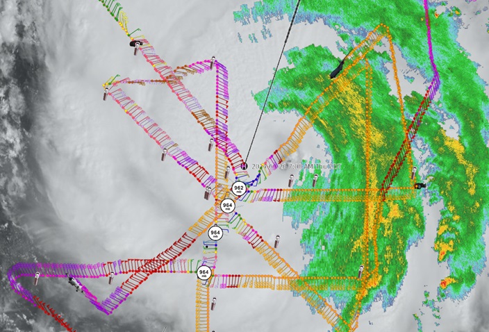
Radar loop on page is showing roughly 3/4 of the eye now, and appears to be veering slightly east of the forecast line.
SFWMD Radar Loop
|
Kraig
Weather Hobbyist
Reged:
Posts: 92
Loc: Jupiter, Fl
|
|
From the 4am Discussion:
"Helene is sending some mixed structural signals this morning. On
one side, an Air Force Reserve Hurricane Hunter aircraft reports
that the central pressure has fallen to near 966 mb, and satellite
imagery shows the eye is trying to clear out. On another side, the
aircraft reported concentric eyewalls of 16 and 32 n mi diameter,
with the maximum flight-level winds, 80 kt at 700 mb, occurring
about 50 n mi southeast of the center likely in relation to the
outer eyewall."
I don't recall any hurricanes 90mph or less with concentric eyewalls or seeming to go through an . I find it quite odd and wonder if it will hinder its top end speed while it loses time going through these physical structure changes. It only is forecasted to have 10 more hours over water....
|
Lamar-Plant City
Storm Tracker

Reged:
Posts: 392
Loc: Plant City, Florida
|
|
Quote:
Am I noticing a jog east on recent satelitte imagery?
I may be a bit paranoid, but it looks to me to be east of forecast track...Gov DeSantis mentioned an east ward shift in his news conference this morning. Anyone else seeing this?
--------------------
If you don't like the weather, wait 5 minutes...
2023 Season Prediction: 17/6/2
|
cieldumort
Moderator

Reged:
Posts: 2738
Loc: Austin, Tx
|
|
Quote:
Quote:
Am I noticing a jog east on recent satelitte imagery?
I may be a bit paranoid, but it looks to me to be east of forecast track...Gov DeSantis mentioned an east ward shift in his news conference this morning. Anyone else seeing this?
There has definitely been a trend to track to the right of the center line since very late last night.
|
Lamar-Plant City
Storm Tracker
Reged:
Posts: 392
Loc: Plant City, Florida
|
|
I used to have a site where it overlay the forecast track on current radar. Seem to have lost it in the computer change or have forgotten where to go for it. Anyone have that?
--------------------
If you don't like the weather, wait 5 minutes...
2023 Season Prediction: 17/6/2
|
Kraig
Weather Hobbyist
Reged:
Posts: 92
Loc: Jupiter, Fl
|
|
Quote:
I used to have a site where it overlay the forecast track on current radar. Seem to have lost it in the computer change or have forgotten where to go for it. Anyone have that?
SFWMD RADAR I posted it a little bit ago as well......
Definitely well east of track!
|
JMII
Weather Master

Reged:
Posts: 549
Loc: Cape Coral, FL
|
|
Quote:
I used to have a site where it overlay the forecast track on current radar.
https://www.wunderground.com/wundermap is another good one where you layer the radar and/or satellite images over the forecast track.
Tide in Ft Myers is already 2.73' above predicted: https://tidesandcurrents.noaa.gov/stationhome.html?id=8725520
|
cieldumort
Moderator
Reged:
Posts: 2738
Loc: Austin, Tx
|
|
Granted, some wobbly still going on, but there keeps being more wobbly to the right, than left of center, and smoothed out over time, a clear bias to the right side of the cone this morning.
|
cieldumort
Moderator
Reged:
Posts: 2738
Loc: Austin, Tx
|
|
|
cieldumort
Moderator
Reged:
Posts: 2738
Loc: Austin, Tx
|
|
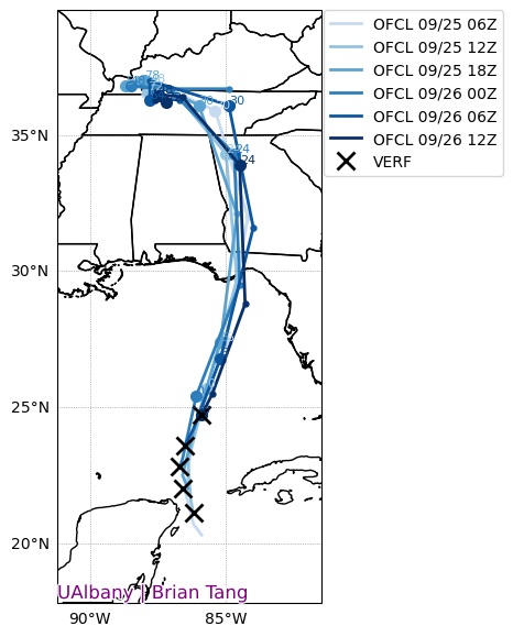
OFCL trends cr. Brian Tang
OFCL(Official forecast track) trends over the past few advisories and verification points. Not that far off from forecast overall.
|
cieldumort
Moderator
Reged:
Posts: 2738
Loc: Austin, Tx
|
|
Winds are now into Category 4 aloft and likely to begin transitioning to the surface. Recon is also finding that the eye is warming and drying considerably, which, baring something unexpected, will support continued intensification this afternoon to a high-end Major heading into landfall.
|
Psyber
Storm Tracker

Reged:
Posts: 242
Loc: Ontario, Canada
|
|
Quote:
OFCL trends cr. Brian Tang
OFCL(Official forecast track) trends over the past few advisories and verification points. Not that far off from forecast overall.
Oh my FREEKING GOD.
If she stays on track, it could PILE DRIVE Big Bend, parts of upper Tennessee, southern Kentucky, northern Alabama, and possibly south Indiana and Illinois with rain. Up to 20 feet of storm surge in Big Bend area.
If it stalls and spins between states, I'm not sure I've ever seen anything close to like this before, other than similar to Harvey, which was mostly in Texas. A quad or quint states potentially needing federal aid on this scale is pretty terrifying. That's not even considering how slow it could go through Georgia and Tennessee before it stalls out more north
--------------------
The safest way to deal with a potential Hurricane hitting you...is to leave and just not be there at all.
|
FlYankee
Registered User

Reged:
Posts: 1
Loc: Rockledge, FL, USA
|
|
Don't overlook the Western Carolinas & Virginia, and perhaps Eastern Kentucky. I have family in Asheville, NC and just outside Greenville, SC, and both have been reporting that flooding had already started for them this morning due to the huge wave of rain pushed over them by Helene. If she keeps sending them rain, there will be some massive flooding in the Smokey Mountains and the Piedmont of the Carolinas. I was in Asheville for (2004) some low areas had 10-20 feet of flood water. We were out shopping (not realizing the amount of rain coming) and had to find an alternate route home because the way we got to the store was under about 6 feet of water in the hour we were in the store! If the numbers on the 's estimated rainfall amounts are even close, this will likely be much worse for those areas, too.
|
JumadukeFL
Registered User
Reged:
Posts: 4
|
|
Well this is positively disconcerting. This is a zoomed-in image from the Wundermap, 6:30pm EST.
Well never mind. I can't insert the image and I can't delete this post. Argh.
Edited by JumadukeFL (Thu Sep 26 2024 06:39 PM)
|
IsoFlame
Weather Analyst

Reged:
Posts: 414
Loc: One block off the Atlantic Oce...
|
|
Hurricane Helene Tropical Cyclone Update
NWS National Hurricane Center Miami FL AL092024
620 PM EDT Thu Sep 26 2024
...HELENE NOW AN EXTREMELY DANGEROUS CATEGORY 4 HURRICANE...
Helene has transitioned to Category 4...
A NOAA Hurricane Hunter aircraft currently investigating Helene
recently found that the maximum sustained winds have increased to
130 mph (215 km/h). The minimum central pressure has also decreased
to 947 mb (27.96 inches) based on dropsonde data.
SUMMARY OF 620 PM EDT...2220 UTC...INFORMATION
----------------------------------------------
LOCATION...28.0N 84.5W
ABOUT 120 MI...195 KM W OF TAMPA FLORIDA
ABOUT 165 MI...265 KM S OF TALLAHASSEE FLORIDA
MAXIMUM SUSTAINED WINDS...130 MPH...215 KM/H
PRESENT MOVEMENT...NNE OR 25 DEGREES AT 23 MPH...37 KM/H
MINIMUM CENTRAL PRESSURE...947 MB...27.96 INCHES
--------------------
CoCoRaHS Weather Observer (FL-VL-42) & Surf Forecaster: https://www.surf-station.com/north-florida-surf-forecast-3/
|
Psyber
Storm Tracker
Reged:
Posts: 242
Loc: Ontario, Canada
|
|
There is a slight bit of good news in there. A 948mb storm tends not to hide a ridiculous amount of strengthening so maybe it'll drop back down to a 3 in the shallow waters around Florida. I worked late, so I'm too tired to look up the SSTs.
I remember 2005 though. 2005 was, unfortunately, one of the worst years ever for low-barometer storms. I remember watching storm after stop after storm, dropping to 900 (Katrina and )
But then showed up and dropped to 870 or 880 MB or something. With , they supported 185mph/300km/hr winds. In the countries that got hit when she was at her strongest, people had the paint sandblasted off their cars.
Wow, it's been almost two decades since we all lived on the site, watching storm after storm pound the GOM and East Coast. It was almost like a malevolent beast was in control of the weather.
--------------------
The safest way to deal with a potential Hurricane hitting you...is to leave and just not be there at all.
|
JMII
Weather Master
Reged:
Posts: 549
Loc: Cape Coral, FL
|
|
Surge in Ft Myers peaked at 5.44 ft just after midnight. Ian peaked at 7.24 for reference.
|


 Threaded

 [Re:
[Re: 

