MikeC
Admin
Reged:
Posts: 4651
Loc: Orlando, FL
|
|
The and Euro (and a few ensembles) have been hinting at a few things the second week of June. Not too concerned about it yet, but worth mentioning in the lounge.
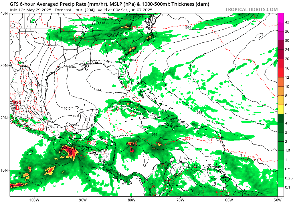
The 12Z Euro has backed off anything happening in the Gulf, so I'd put money on nothing happening, but watch the west carib anyway as ensembles have increased in the area though..
|
MikeC
Admin
Reged:
Posts: 4651
Loc: Orlando, FL
|
|
Gfs still mostly alone, but noting the east pacific pop up here as well. Something to watch, but doubt either of the runs from today materialize. In other words, it's likely if something happens, the east pacific is more likely.
|
IsoFlame
Weather Analyst

Reged:
Posts: 380
Loc: One block off the Atlantic Oce...
|
|
Quote:
Gfs still mostly alone, but noting the east pacific pop up here as well. Something to watch, but doubt either of the runs from today materialize. In other words, it's likely if something happens, the east pacific is more likely.
Yeppers... may be crying wolf, but the 06Z run doubled down on a strong TC in the GOMEX June 9/10th eyeballing landfall near Biloxi as a fairly strong hurricane. Yes, hurricanes are rare in early June and we have a deep trough setting us up for an unusual June 1st FROPA, but SST's in the central and eastern GOMEX are climbing into the mid-80's and the atmospheric parameters will become favorable the second week in June when the Atlantic ridge re-establishes. Either other models start to hit on this, or the totally abandons the idea in future runs. We shall see...
06zMay30
--------------------
CoCoRaHS Weather Observer (FL-VL-42) & Surf Forecaster: https://www.surf-station.com/north-florida-surf-forecast-3/
Edited by IsoFlame (Fri May 30 2025 08:38 AM)
|
MikeC
Admin
Reged:
Posts: 4651
Loc: Orlando, FL
|
|
6z is a bit on the crazy side for kicking off on the 20th anniversary year of , euro operational doesn't show anything, however several ensembles do. And the ensembles are also suggesting something could form in a week.from Monday or so.
|
MikeC
Admin
Reged:
Posts: 4651
Loc: Orlando, FL
|
|
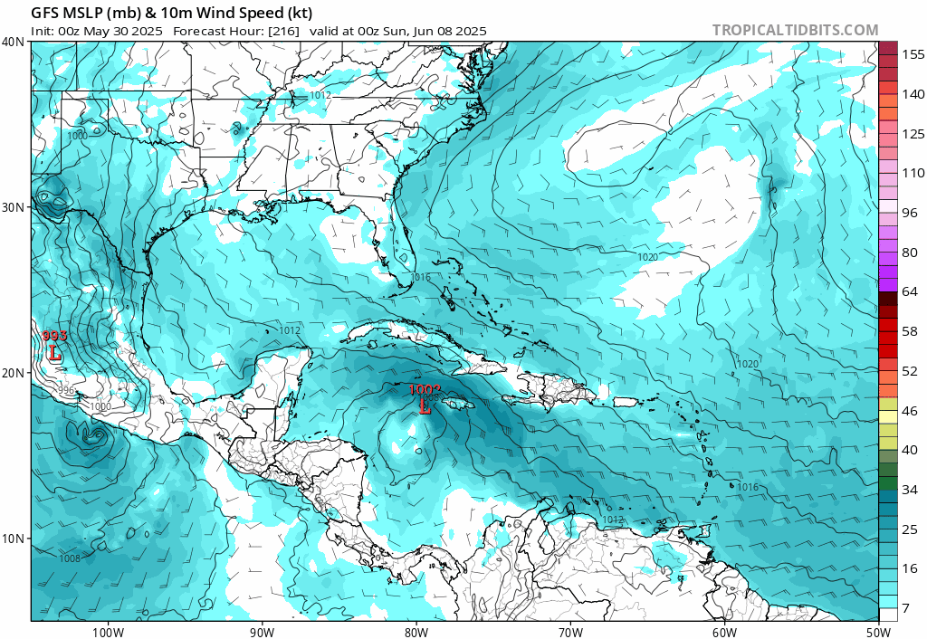
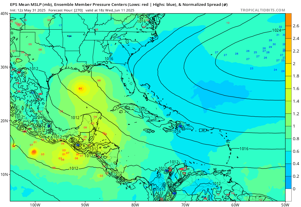
12z shifted back to a hurricane impact on florida
Probably the best idea is to watch ensembles a bit more until the day range closes, the euro still has a few ensemble members, but mostly west. Too soon to really say on it. But in this run the starts to develop it on June 7th in the West Caribbean.
The typically overdoes this situation, but there is a few euro ensembles also involved, so there's a slight chance something may develop, but unlikely to be this powerful.
|
MikeC
Admin
Reged:
Posts: 4651
Loc: Orlando, FL
|
|
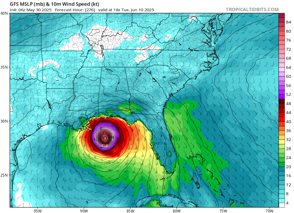
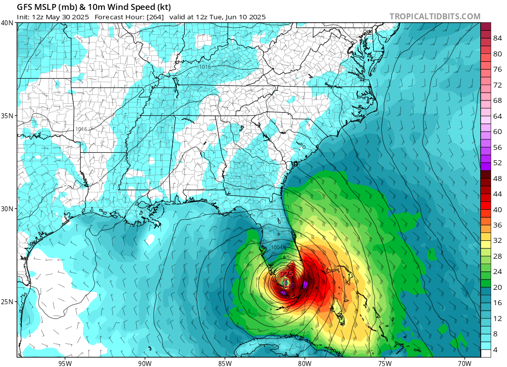
The operation continues to show development, whereas the others do not. (18z is back to a major hit on LA/MS)
However there still are signals on the Euro Ensembles for something
Euro Ensembles:
GFS Ensembles:
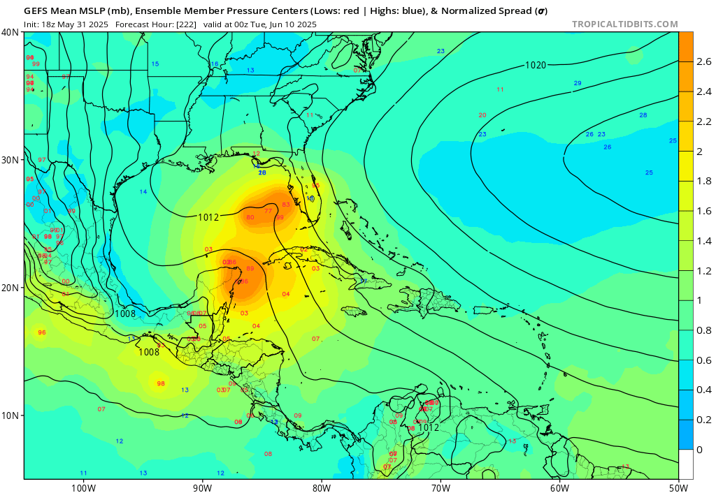
There is also a weak area off the SE (and FLorida) that the Euro and Canadian pick up.
Normally I'd write of the , and mostly I do, but the , Euro ensembles, make me think there's a chance something tries to develop, I just doubt it'll be anything like the has been showing. (And may not succeed)
Another view of the Euro Ensembles:
Overall, the East Pacific is much more likely to see another system than the Atlantic
|
MikeC
Admin
Reged:
Posts: 4651
Loc: Orlando, FL
|
|
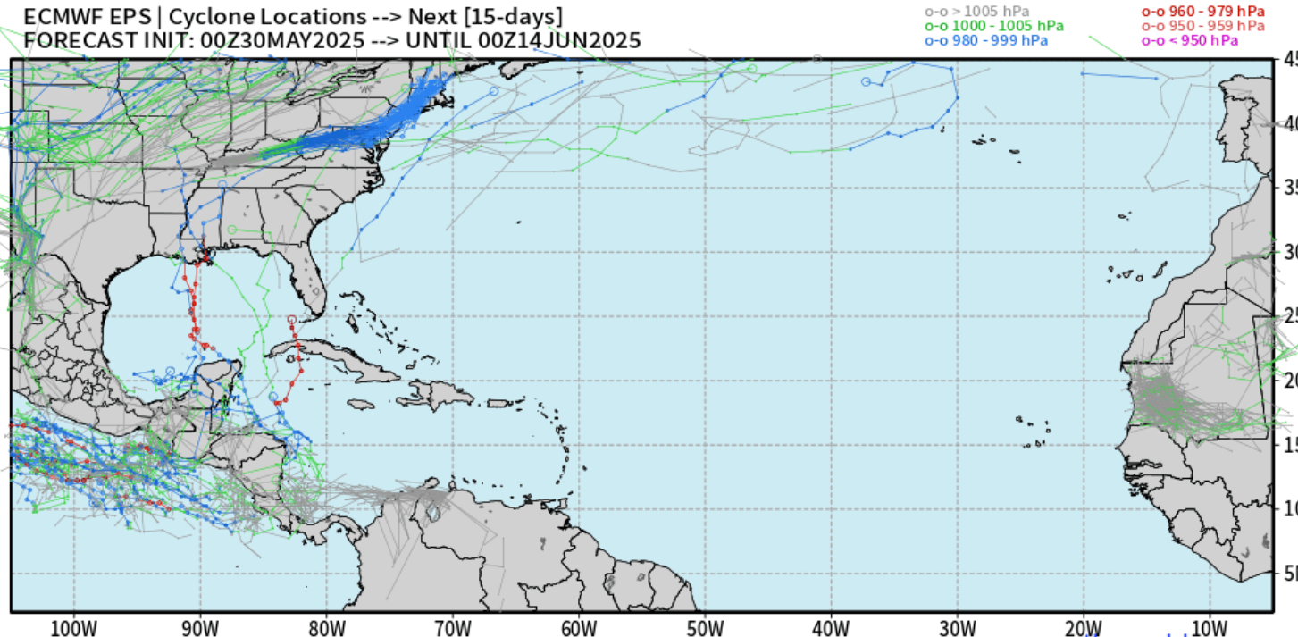
The southeast coast looks more liekly than the at this point, however there's still long range ensemble members showing something in the gulf also, but later on (June 12th or so)
The euro ensemble tracks for the Southeast System, which may get a lemon on the outlook tomorrow.
The is falling back on the idea it had earlier, going later and further west, which may wind up getting pushed into the east pacific. However worth noting is the euro ensembles here:
which are showing something there in the very long range. Just not what the was showing.
|
MikeC
Admin
Reged:
Posts: 4651
Loc: Orlando, FL
|
|
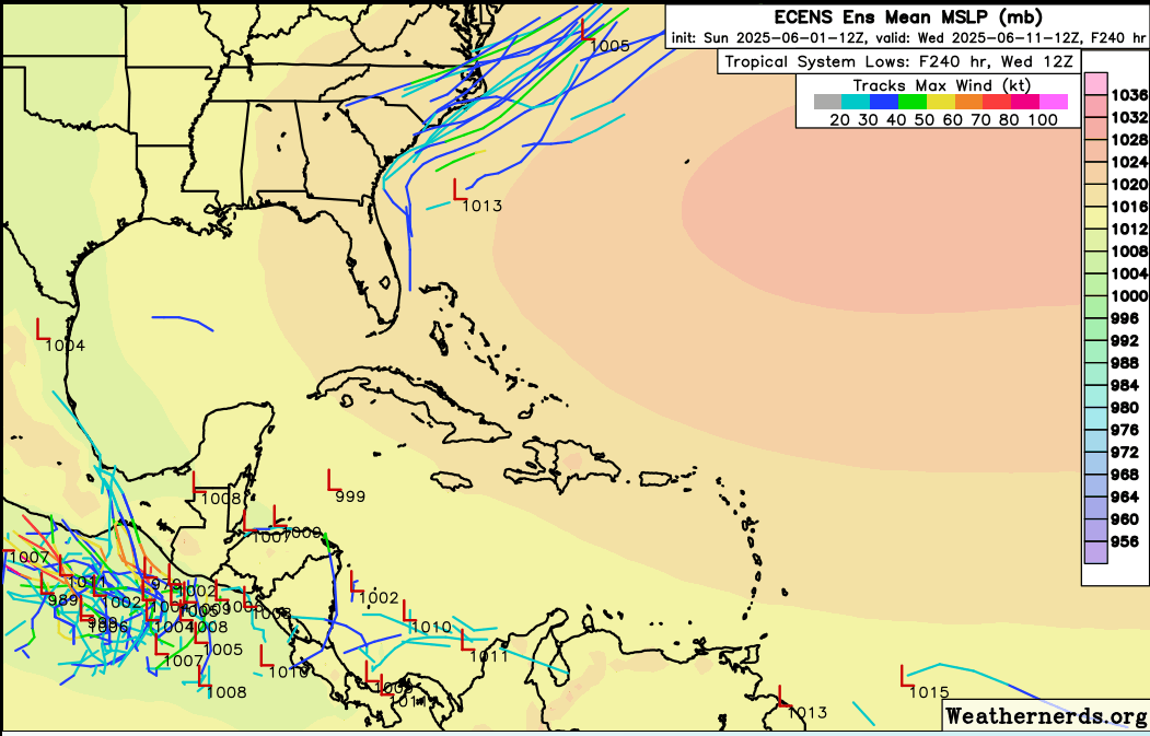
The system has shifted again to the west and is no longer in the Gulf, and its now showing that energy moving into the east Pacifc, another potential phantom is behind it. If you are curious why there wasn't too much talk about the earlier runs, this is why since the early season bias in this region is notorious and why you look look for more than a single models support. weak indications on the euro ensembles, non withstanding. .
What to look for ijn the bias runs is 1, no or very little other model support, 2. tendency to push the timeframe back every day. And this was no exception here. (GFS is showing another West Caribbean system at the tail end of the 6z run this morning -- around June 16th)
|
IsoFlame
Weather Analyst
Reged:
Posts: 380
Loc: One block off the Atlantic Oce...
|
|
Quote:
The system has shifted again to the west and is no longer in the Gulf, and its now showing that energy moving into the east Pacifc, another potential phantom is behind it. If you are curious why there wasn't too much talk about the earlier runs, this is why since the early season bias in this region is notorious and why you look look for more than a single models support. weak indications on the euro ensembles, non withstanding. .
What to look for ijn the bias runs is 1, no or very little other model support, 2. tendency to push the timeframe back every day. And this was no exception here. (GFS is showing another West Caribbean system at the tail end of the 6z run this morning -- around June 16th)
My take too. Still, there was some consistency (location/timing) in runs early on, but other models didn't give it a nod so you are spot on with not biting as the gradually pushed out the time frame and changed the track in the Gulf, then added another spin up at the tail end of the run. Hope the sometimes early harbinger model can get back on track as the season progresses.
--------------------
CoCoRaHS Weather Observer (FL-VL-42) & Surf Forecaster: https://www.surf-station.com/north-florida-surf-forecast-3/
|
MikeC
Admin
Reged:
Posts: 4651
Loc: Orlando, FL
|
|
The next few weeks look to be quiet in the Atlantic.
|
MikeC
Admin
Reged:
Posts: 4651
Loc: Orlando, FL
|
|
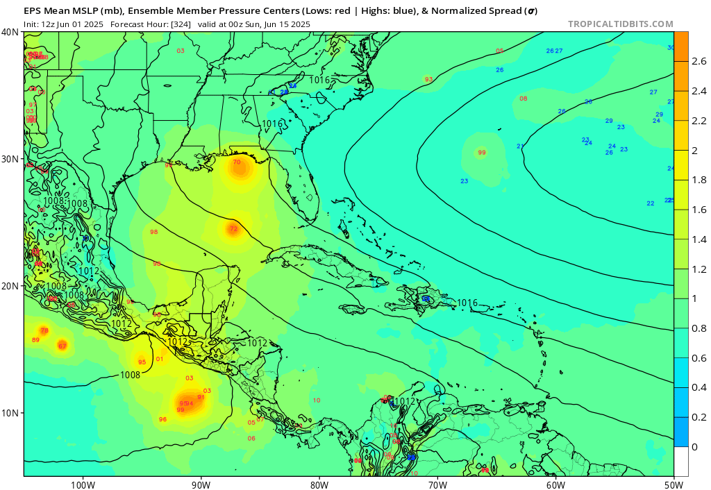
The model keeps placings storm near around the West Caribbean into the gulf in a week to 10 days, however, again the other models don't do anything with it. been in the "week to 10 days" mode for over 10 days now, so it shifts the timeframe back. The Venezuela mountain induced vorticity flaw the model has is really on display this year. However, the flooding rainfall in Central America is real, the hurricanes are not. The pattern for these style phantom storms is they get delayed and/or shifted further west/south until it doesn't exist anymore.
The East Pacific will probably see the most activity from the energy/moisture once beyond central America. But again, it looks like another quiet week in the Atlantic basin.
|
MikeC
Admin
Reged:
Posts: 4651
Loc: Orlando, FL
|
|
Still remains very quiet in the Atlantic, but the east pacific is showing quite strong ensembles on the Euro, potentially the first major coming in the east Pacific.
This year so far has remained more like typical hurricane season, where most of the early activity remains in the East Pacific. It's seeming more likely we won't see anything in June, and probably little to nothing in July based on the patterns of similar years past. The next real sign is watching for when the main development region gets active and the classic waves start to show up. A weak one or two may start to appear in about two weeks, but anything this early would likely not form.
|


 Threaded


