cieldumort
Moderator

Reged:
Posts: 2535
Loc: Austin, Tx
|
|
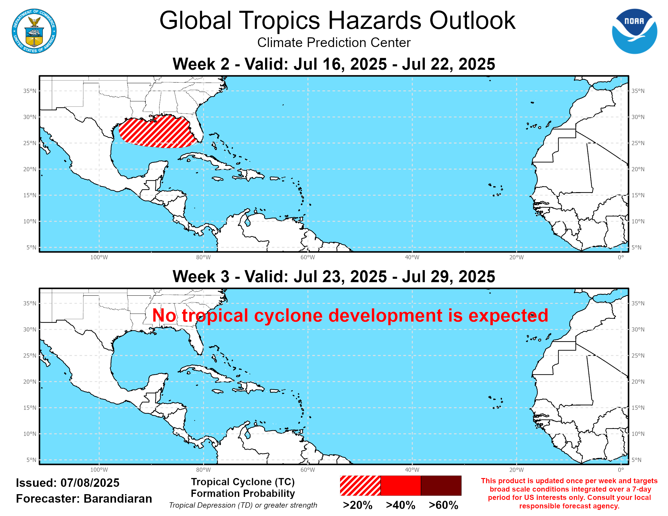
Have started a thread just for the BOC Area of Interest over in The Tropics Today: W Gulf this weekend .
now up to 30% if/once the disturbance has moved into the Bay of Campeche.
In order to realize its potential, the disturbance would have to spend enough time over the water and within what looks to be a rather small corridor of lower shear. No Invest tag yet, but will consider inclusion to the Forecast Lounge if these preconditions look to be coming together.
|
MikeC
Admin
Reged:
Posts: 4701
Loc: Orlando, FL
|
|
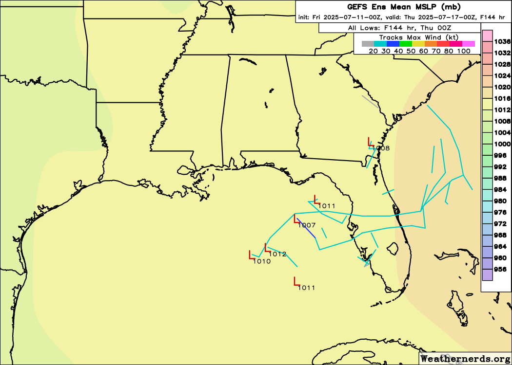
Multiple models showing something next weekend around the southeast, mostly offf the Southeast, but the is pushing for something in the Gulf near the Panhandle over the energy going off the southeast where most of the other models have it developing, including hte , Icon, and Euro and the google deepmind model has a large spread here also.
Nothing stronger than a weak TS in any of these though.
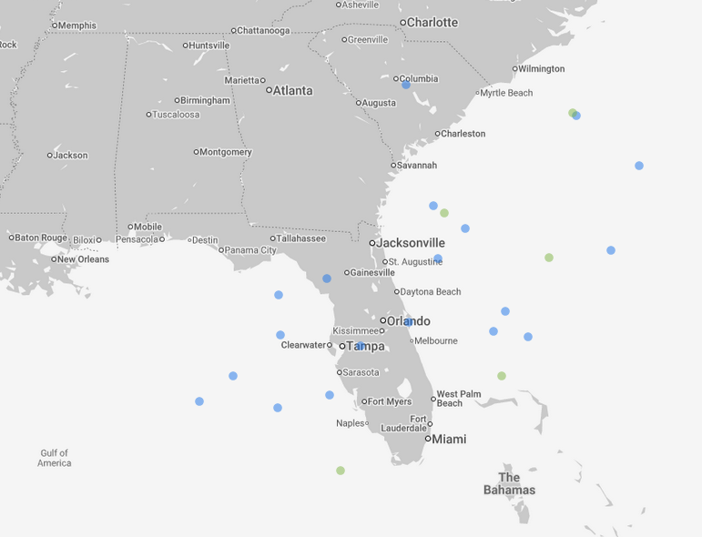
Image frame targeting sunday morning next week
|
MikeC
Admin
Reged:
Posts: 4701
Loc: Orlando, FL
|
|
18z went a bit wild, but doesn't have much support elsewhere
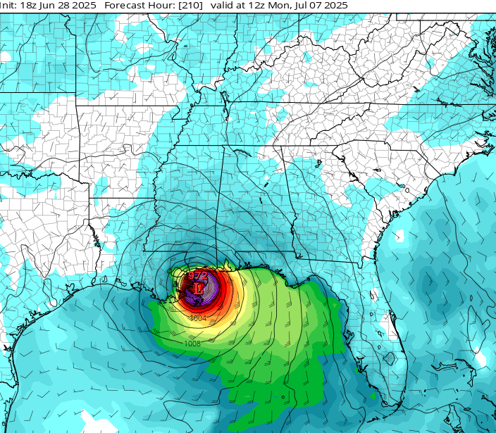
This is very unlikely, however it does show the heat content in that part of the Gulf (which is very hot right now)
12z Euro keeps it weak and moves it off the southeast (icon does also)
Euro ensembles are mostly off the southeast coast, where ensembles have it more in the northwast Gulf. It's looking more likely there may be something to watch for on the holiday weekend. Note, before this it means it's likely to be HEAVY ranfall over much of Central and North FLorida later in the week, regardless of development.
|
MikeC
Admin
Reged:
Posts: 4701
Loc: Orlando, FL
|
|
Overnight model runs have backed off on development, but the general area of heavy rain remain.
|
MikeC
Admin
Reged:
Posts: 4701
Loc: Orlando, FL
|
|
Beyond Chantal, the next hotspot may be the northeast Gulf in a week or so, but again, unlikely to develop much. (But Chantal was also unlikely)
|
CFHC

Reged:
Posts: 178
Loc: East Central Florida
|
|
12z Euro is surprisingly strong with vorticity on the Gulf area, over the which isn't.
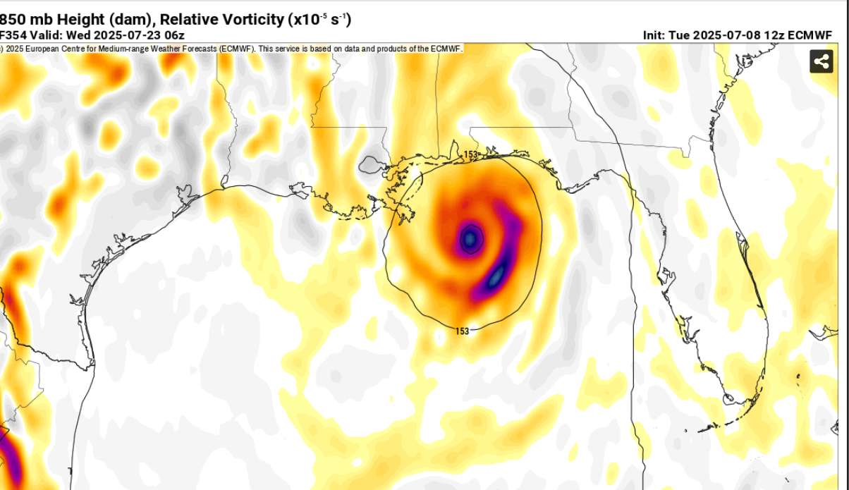
matches
Edited by MikeC (Tue Jul 08 2025 08:09 PM)
|
MikeC
Admin
Reged:
Posts: 4701
Loc: Orlando, FL
|
|
Overnight models backed off on this one, except for the .
|
MikeC
Admin
Reged:
Posts: 4701
Loc: Orlando, FL
|
|
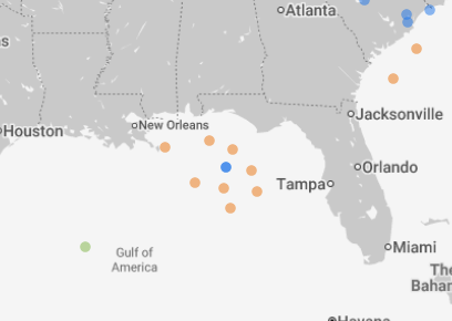
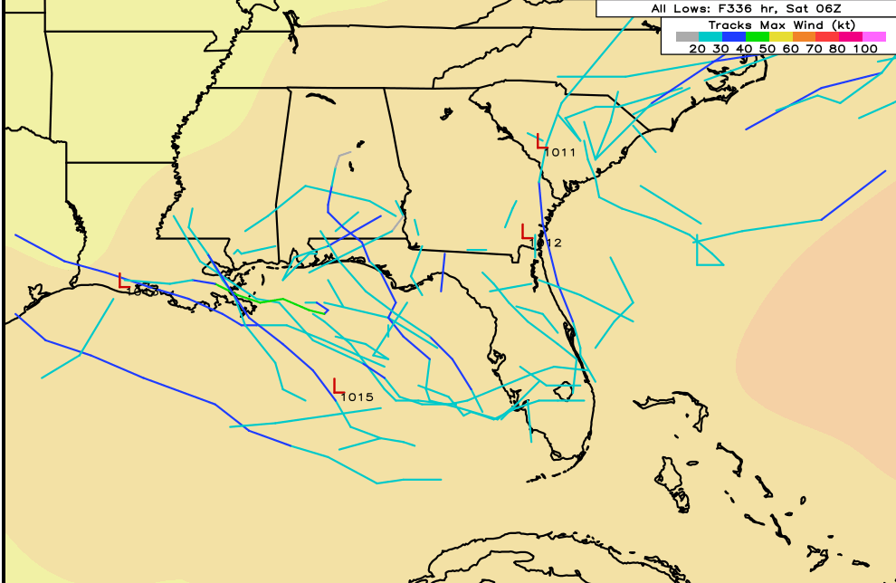
The Gulf area mentioned in the models is interesting, a lot of mixed signals, but enough to make it worth watching into next week, again another case where the models are having a hard time consolidating on anything. It'll likely be something that slips off the atlantic then goes back into the Gulf and it may sit around enough to develop. Ensembles pick it up better than the operational models right now.
Effectively the dot cluster in this map (in a week)
|
CFHC
Reged:
Posts: 178
Loc: East Central Florida
|
|
Less activity today on the euro, more on the
|
MikeC
Admin
Reged:
Posts: 4701
Loc: Orlando, FL
|
|
a Little more activity on the ensembles this evening (both Euro and )
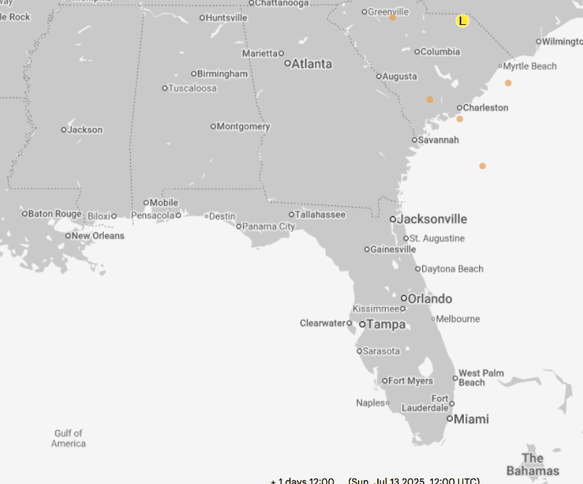
What to watch is the area off south carolina moving south, crossing over Florida, bringing more rain, then into the Gulf, where it has a small chance to develop. Mid to late week.
|
MikeC
Admin
Reged:
Posts: 4701
Loc: Orlando, FL
|
|
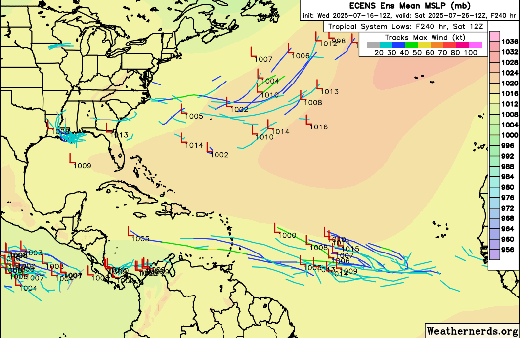
Euro ensembles are showing some activity in the MDR late next week. (Also a few members for 93L)
|
cieldumort
Moderator
Reged:
Posts: 2535
Loc: Austin, Tx
|
|
Conditions basin-wide in the Atlantic may be flipping from unfavorable to slightly favorable as we enter the back half of July. This could allow for more than just home-grown systems to stand a chance for at least a little while.
As noted by Andy Hazelton, Associate Scientist at the University of Miami CIMAS, on XQuote:
Recent trade wind patterns (weakened across the Atlantic, stronger across the East Pacific) have led to warming of the Atlantic MDR and cooling of . The Atlantic is now slightly warm relative to the global tropics, in a more favorable configuration than we've seen since Spring.
|
MikeC
Admin
Reged:
Posts: 4701
Loc: Orlando, FL
|
|
MDR Activity is shown on muiltiple models as soon as Monday or so. (GFS/Euro/Canadian and the ensembles all show something roughly 12n 45w
|
CFHC
Reged:
Posts: 178
Loc: East Central Florida
|
|
12z euro also showing the MDR system, those in the Leewards and Barbados should keep an eye on it, I suspect the 8pm tropical weather outlook will call it out since it's been multiple runs/models at this point.
Luckily it gets sheared out beyond there.
|


 Threaded


