cieldumort
Moderator

Reged:
Posts: 2531
Loc: Austin, Tx
|
|
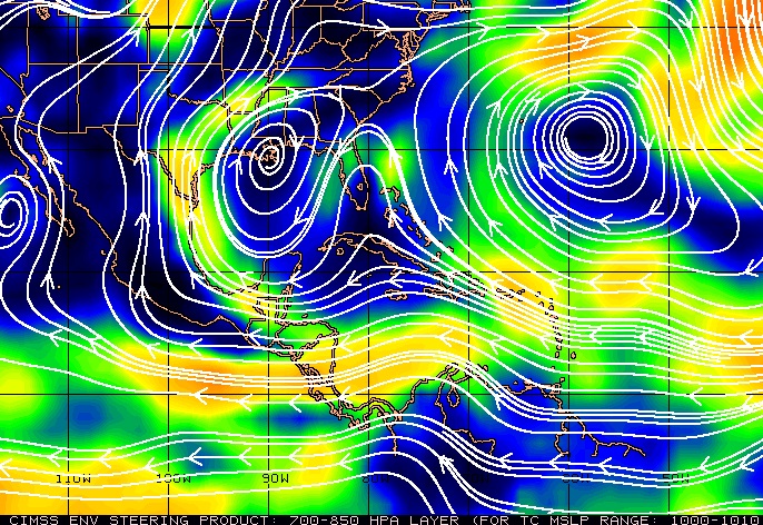
93L may have achieved just enough organization and latitude to be influenced by the mean steering winds off the southeast coast. As can be seen in the CIMSS ENV Deep Layer Wind product above ("Satellite-derived Atmospheric Motion Vectors produced at CIMSS"), as long as 93L remains east of Florida it may go poleward, so much so, that it never really has a chance to cook in the Gulf.
|
MikeC
Admin
Reged:
Posts: 4696
Loc: Orlando, FL
|
|
93L is probably not going to become a depression before Florida it's almost inland near the Volusia/Brevard border, but it's close. Probably 1012mb, with 25-30mph winds.
Once over the Gulf, that far north moderate shear will likely have more of an impact and keep 93L weaker. I'd say the 40% chance is still good. I don't expect any tropical advisories issued today with the mid-level vorticity moving over land. LLC is still broad north to south, with the one off Brevard/Volusia line being the strongest at the moment.
timelapsing the Flagler beach cam in NSB https://flhurricane.com/imageanimator.php?926
|
IsoFlame
Weather Analyst

Reged:
Posts: 384
Loc: One block off the Atlantic Oce...
|
|
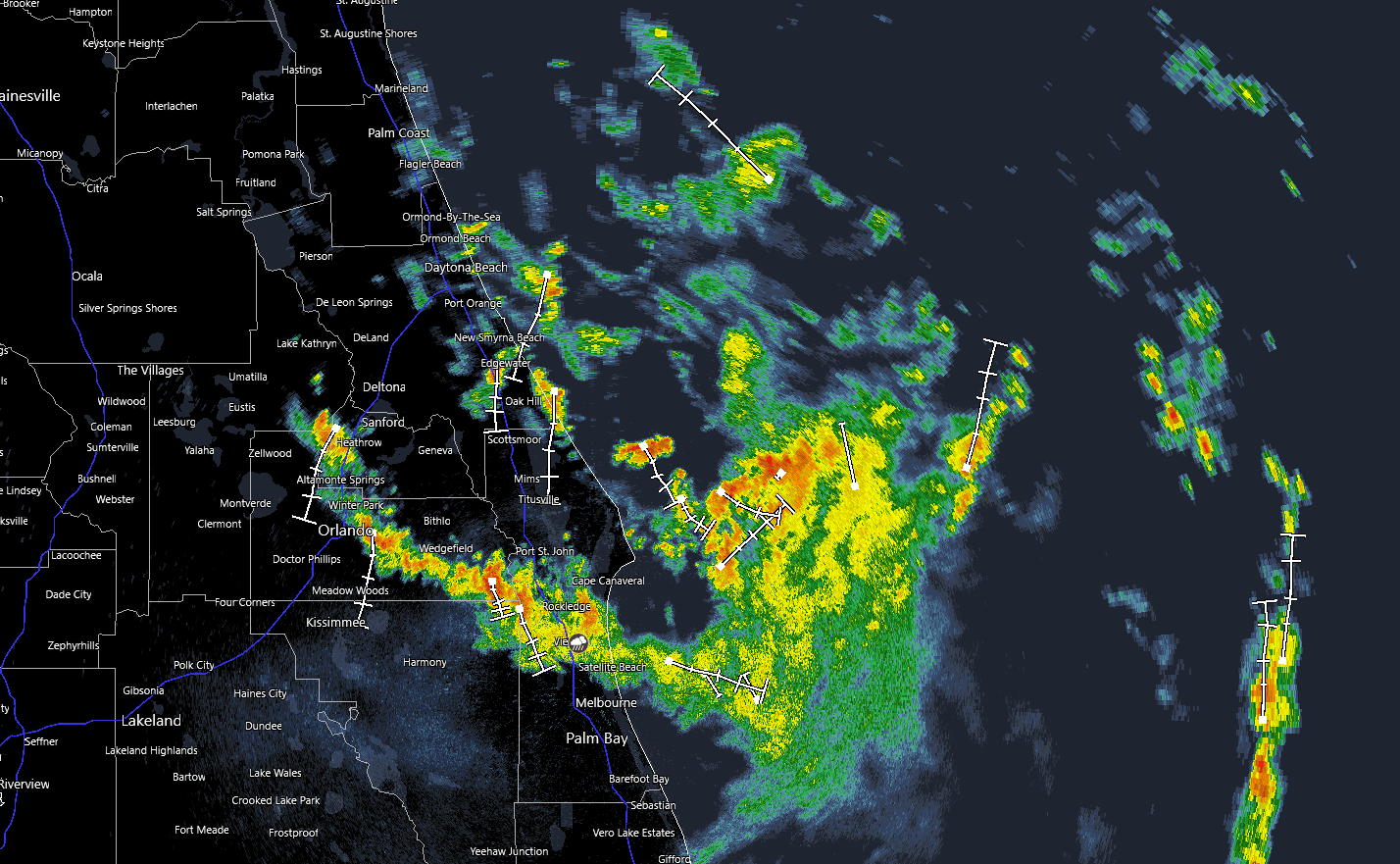
Given the slow movement of 93L with the broad circulation "centered" just east of Ponce Inlet, a band of moderate to heavy rain has set up in a NE to SW fashion and is currently training in off the Atlantic over and just south of SR 44 in New Smyrna Beach. Widespread rain of 1-2 inches likely, localized amounts could exceed 5 inches today.
Flood Watch
National Weather Service Melbourne FL
957 AM EDT Tue Jul 15 2025
.An area of low pressure will push onshore the east central Florida coast this morning and move westward across the area today.
Persistent bands of heavier showers and storms associated with this system will produce widespread rainfall totals of 1 to 3 inches,
with localized totals of 4 to 7 inches. This rainfall will be capable of producing isolated flash flooding across the watch area today.
--------------------
CoCoRaHS Weather Observer (FL-VL-42) & Surf Forecaster: https://www.surf-station.com/north-florida-surf-forecast-3/
|
IsoFlame
Weather Analyst
Reged:
Posts: 384
Loc: One block off the Atlantic Oce...
|
|
Following a cloudy morning with light rain and drizzle here in Daytona Beach Shores, a band of heavy rain just started coming in off the Atlantic. NWS Melbourne just expanded the flood advisory:
1043 AM EDT Tue Jul 15 2025
...FLOOD ADVISORY IN EFFECT UNTIL 1215 PM EDT THIS AFTERNOON...
* WHAT...Flooding caused by excessive rainfall is expected.
* WHERE...A portion of east central Florida, including the following counties, Brevard, Seminole and Volusia.
* WHEN...Until 1215 PM EDT.
* IMPACTS...Minor flooding in low-lying and poor drainage areas. Overflowing poor drainage areas.
* ADDITIONAL DETAILS...
- At 1042 AM EDT, Doppler radar and automated rain gauges indicated heavy rain due to slow moving showers and
thunderstorms. Minor flooding is ongoing or expected to begin shortly in the advisory area. Between 2 and 3 inches of rain
have fallen. Additional rainfall amounts of 2 to 3 inches are expected over the area. This additional rain will result in minor
flooding.
- Some locations that will experience flooding include...
Deltona, Port Orange, Sanford, Titusville, DeLand, New Smyrna Beach, Edgewater, Lake Mary, Orange City, Lake Helen, Oak
Hill, Geneva, Scottsmoor, Mims, Lake Jesup, Haulover Canal, DeBary, Playalinda Beach, Maytown and Osteen.
--------------------
CoCoRaHS Weather Observer (FL-VL-42) & Surf Forecaster: https://www.surf-station.com/north-florida-surf-forecast-3/
|
cieldumort
Moderator
Reged:
Posts: 2531
Loc: Austin, Tx
|
|
93L has had a well-defined circulation all morning, but showers and thunderstorms remain largely disorganized owing to ongoing bouts of moderate north to northeasterly shear.
The cyclone is now tracking north-northwest as advertised by many recent model runs, roughly parallel to the east coast of Florida, and on this track would make "landfall" somewhere near the FL/GA border, provided it doesn't hook left before then. Considering this track and its now increasingly northerly location, more questions are raised about its ability to reconstitute itself in the Gulf, if/when it ever gets into the Gulf.
|
MikeC
Admin
Reged:
Posts: 4696
Loc: Orlando, FL
|
|
Rain is coming to a pretty concentrated area from Daytona beach, with a vort eddy circulating around the bigger low that's onshore now, with the eddy about to come in around St. Augustine. Gulf side it could, depending on timing, form again there, but it would be relatively close to the north Gulf coast. Most rain will be offshore on the Gulf side, so until landfall most of the rain is going to be now in Florida, expanding into the afternoon, and less so once into the Gulf.
|
cieldumort
Moderator
Reged:
Posts: 2531
Loc: Austin, Tx
|
|
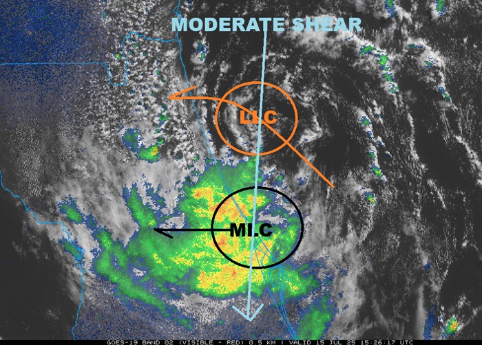
Moderate north-northeasterly wind shear on the order of 15-30 knots continued to plague 93L for too long, preventing the surface circulation from colocating with the mid-level center aloft (up several thousand feet), with the deep convection still only associated with the circulation aloft, and the window for 93L to become a TD prior to crossing Florida has all but closed. There are however suggestions that the mid-level circulation is strong enough to either pull in the surface low, eventually, or perhaps form a new one. This would be the possible scenario outlined for development once in the northern Gulf later this week.
Regardless of classification, 93L is a copious rain-maker for much of the state of Florida, and later this week could become a very serious flood threat for south-central states.
|
cieldumort
Moderator
Reged:
Posts: 2531
Loc: Austin, Tx
|
|
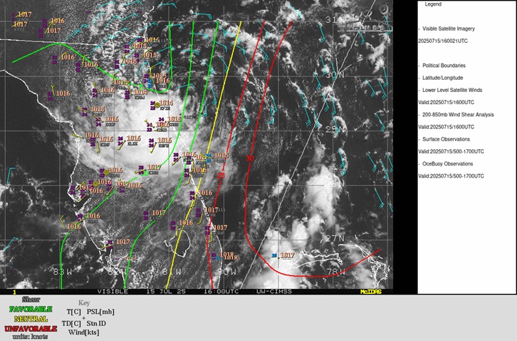
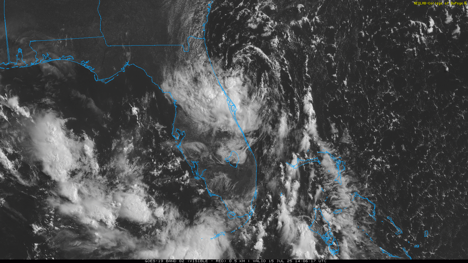
Above: 93L analysis cr. CIMSS
An analysis of the very last few visible satellite and radar frames, along with land and ocean-based weather stations, point to 93L's surface circulation hooking SW, being drawn back in closer to the circulation aloft, as shear, at last, begins relaxing, as can been seen analyzed in the CIMSS 200-850mb Wind Shear Analysis. This could give 93L a better shot out the gate for development once it enters the northern Gulf, which now appears more likely, and provide a much more TD-like feel as it crosses the state.
|
cieldumort
Moderator
Reged:
Posts: 2531
Loc: Austin, Tx
|
|
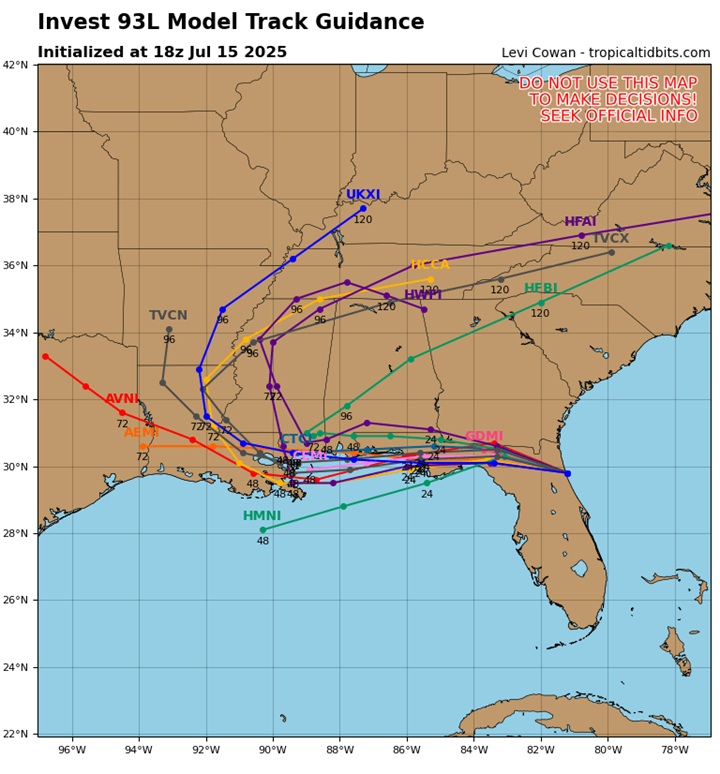
Most of today's 18Z mode runs initialize 93L quite a bit farther north, but possibly a touch too far north based on the most recent trends noted in the above post.
If 93L can continue to consolidate a little south of these 18Z run initializations, it would likely fare better odds at becoming an officiated TC as there would be more time over water. However, even if it doesn't, there looks to be "just enough" water, swamp and brown ocean to allow for continued gradual organization.
The 40% looks reasonable, given the known unknowns. Once 93L is west of the peninsula, and provided it is over enough Gulf water, recon missions will be invaluable in giving us a better forecast.
|
MikeC
Admin
Reged:
Posts: 4696
Loc: Orlando, FL
|
|
It's opening up into a trough again, was more organizer earlier today.
If the MLC wins out and pulls the top down it has a chance to restrengthen, but none of this really can happen until all of it clears the Florida peninsula. North end will die out because of land, it's a question if the southern part takes over or not.
|
cieldumort
Moderator
Reged:
Posts: 2531
Loc: Austin, Tx
|
|
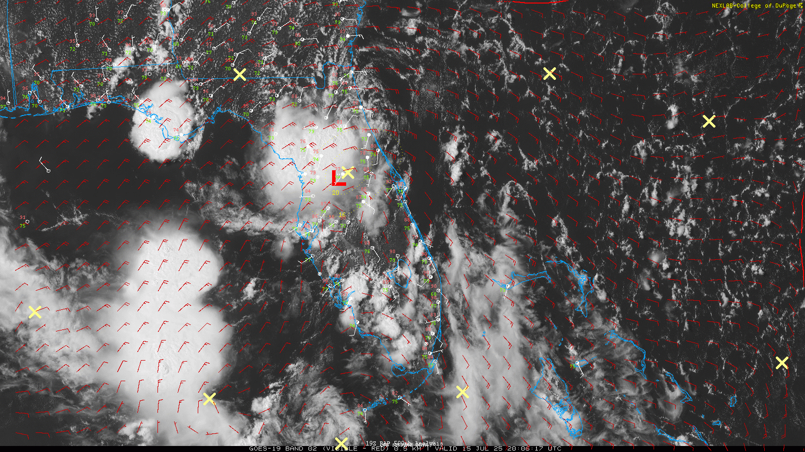
Interesting last couple hours of visible satellite imagery, 500mb RAP analysis (red barbs, red "L"s and yellow "X"s), and surface station plots.
|


 Threaded


