Current Radar or Satellite Image

Flhurricane.com - Central Florida Hurricane Center - Tracking Storms since 199530 Years of Hurricanes Without the Hype - Since 1995


Watching a 20% area in the east Antialnic. Conditions ahead of it are not very condusive for development. Right now, odds keep it likely weak/no development and it curves east of Bermuda.
Days since last H. Landfall - US: Any 323 (Milton) , Major: 323 (Milton) Florida - Any: 323 (Milton) Major: 323 (Milton)
41.2N 42.9W
Wind: 45MPH
Pres: 1009mb
Moving:
Ene at 23 mph
Click for Storm Spotlight
COMMUNICATION
STORM DATA
CONTENT
FOLLOW US


General Discussion >> 2025 Forecast Lounge

Pages: 1 | 2 | (show all)
MikeCAdministrator
Admin


Reged:
Posts: 4781
Loc: Orlando, FL
Re: Erin Forecast Lounge [Re: MikeC]
      #115755 - Sat Aug 16 2025 10:46 AM

12z models are likely going to a bit off based on how rapidly the situation changed with Erin this morning, later runs may have caught up more. However, the major pattern hasn't changed, maybe shifted left some. Important to watch this though.

Post Extras: Print Post   Remind Me!   Notify Moderator  
MikeCAdministrator
Admin


Reged:
Posts: 4781
Loc: Orlando, FL
Re: Erin Forecast Lounge [Re: MikeC]
      #115759 - Sat Aug 16 2025 01:54 PM

12z Icon, Euro, and the UKMet are all showing tropical storm force winds along the outer banks when it gets up there. GFS is still east of it. None of them had intensity correct, however.

Post Extras: Print Post   Remind Me!   Notify Moderator  
cieldumort
Moderator


Reged:
Posts: 2594
Loc: Austin, Tx
Re: Erin Forecast Lounge [Re: MikeC]
      #115760 - Sat Aug 16 2025 02:48 PM

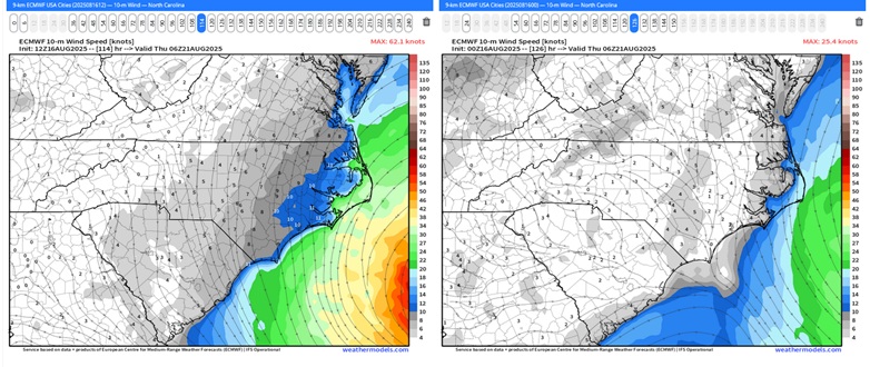
Today's 12Z vs 0z ECMWF for Thursday 8/21/25 0z

This would bring very rough, truly life-threatening surf conditions to the OBX, to say nothing of the chance of a further westward adjustment wrt the wind.


Post Extras: Print Post   Remind Me!   Notify Moderator  
cieldumort
Moderator


Reged:
Posts: 2594
Loc: Austin, Tx
Re: Erin Forecast Lounge [Re: MikeC]
      #115763 - Sat Aug 16 2025 05:27 PM

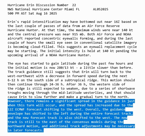
NHC explicitly advertising that further forecast cone adjustments to the west may be coming


Post Extras: Print Post   Remind Me!   Notify Moderator  
cieldumort
Moderator


Reged:
Posts: 2594
Loc: Austin, Tx
Re: Erin Forecast Lounge [Re: MikeC]
      #115767 - Mon Aug 18 2025 03:46 AM

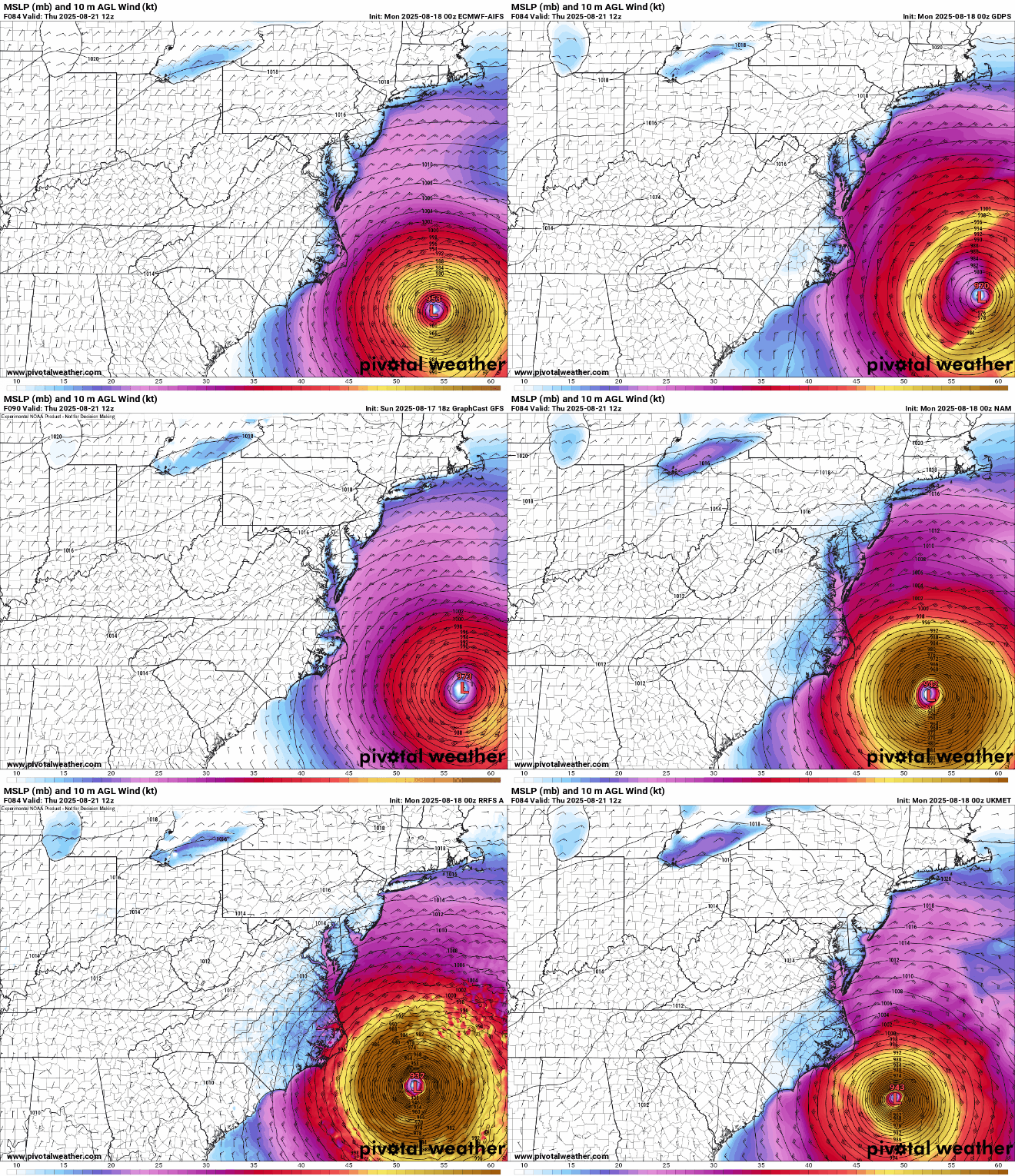
As Erin keeps expanding, the radius of tropical storm force and hurricane force winds have a good chance of being considerably larger than depicted in the models below. Waves and potentially coastal flooding may also be more significant than these runs suggest.

AIFS, ECMWF, GDPS, GFS, GraphCast GFS, ICON, NAM, RDPS, RRS A, UKMET
Valid Thursday 8/21/12z

Post Extras: Print Post   Remind Me!   Notify Moderator  
Bloodstar
Moderator


Reged:
Posts: 468
Loc: Tucson, AZ
Re: Erin Forecast Lounge [Re: cieldumort]
      #115773 - Mon Aug 18 2025 09:23 PM

I have found it fascinating watching the model output consistently nudge west. And are my eyes deceiving me or has the storm really slowed down, almost like it's drifting NNW right now.

Just remarking, nothing rigorous right now.

--------------------
M. S. Earth and Atmospheric Sciences, Georgia Tech - May 2020
U. Arizona PhD Student


Post Extras: Print Post   Remind Me!   Notify Moderator  
Pages: 1 | 2 | (show all)


Extra information
0 registered and 3 anonymous users are browsing this forum.

Moderator:  

Print Topic

Forum Permissions
      You cannot start new topics
      You cannot reply to topics
      HTML is disabled
      UBBCode is enabled

Rating:
Topic views: 5835

Rate this topic

Jump to

Note: This is NOT an official page. It is run by weather hobbyists and should not be used as a replacement for official sources. 
CFHC's main servers are currently located at
Hostdime.com in Orlando, FL.
Image Server Network thanks to Mike Potts and Amazon Web Services. If you have static file hosting space that allows dns aliasing contact us to help out! Some Maps Provided by:
Great thanks to all who donated and everyone who uses the site as well. Site designed for 800x600+ resolution
When in doubt, take the word of the National Hurricane Center