MikeC
Admin
Reged:
Posts: 4811
Loc: Orlando, FL
|
|
Recon is finding the center relatively dry which should keep it from gaining much today. It's mostly a waiting game, Jamaica and points east of wherever the center winds up are going to see the most impacts. Bahamas, Berumda will also want to keep watch once Melissa begins to move, which may not be for a good while (days). I am not concerned for Florida at all for any direct impacts.
|
cieldumort
Moderator

Reged:
Posts: 2656
Loc: Austin, Tx
|
|
Recon, which is still in Melissa, has provided very useful information, much of which is now fed into models and official forecasts.
There are generally two model camps with regard to the cyclone's future:
1. More rapid near-term development/deeper cyclone, favoring a track towards/near/roughly or directly across Hispaniola, and out-to-sea.
2. Slower near-term development/shallower cyclone, favoring a track that misses the first exit, and hooks w or even wsw towards Nicaragua/Honduras, and explosively develops into a history-making-level Major.
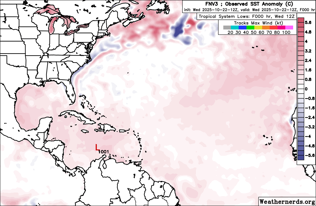
This morning's two recon missions suggest that a third camp may emerge in subsequent runs, as the center has reformed northeast of its prior location, into very deep convection. Recon passes have found that pressures have fallen to about 1001mb, with winds, so far, not responding, but likely to do so.
Melissa's forecast is extraordinarily tricky, with several opportunities to escape the Caribbean, but even more opportunities to meander, stall, and even drift southwest. This far greater than usual uncertainty was reflected in the 5AM Advisory Quote:
this should be considered an extremely uncertain forecast, and significant changes could be required
Also, the US East coast is not off the hook, longer-term.
|
cieldumort
Moderator
Reged:
Posts: 2656
Loc: Austin, Tx
|
|
Now that we have invaluable recon data to consider, I am updating my 98L (now Melissa) lifetime maximum intensity best guesses. This is not a forecast for Melissa's intensity at landfall/s.
50 MPH Tropical Storm (Current state): Close to 0%
60-70 MPH mid/high-end Tropical Storm: 1%
Cat 1 Hurricane: 3%
Cat 2 Hurricane: 5%
Cat 3 Hurricane: 14%
130-140 MPH Cat 4 Hurricane: 17%
150-155 MPH High-End Cat 4: 19%
160-170 MPH Cat 5: 20%
175-200 MPH Cat 5: 19%
Over 200 MPH Cat 5: 2%
In summary: Current state: Nearly 0%. Odds of becoming a hurricane of any category: 99%. Odds of becoming a Major Hurricane 91%. Odds of becoming a Cat 5: 41%
This is all based on the Saffir-Simpson Scale, which is to say, just wind. Rainfall, flooding, mudslides and surge from Melissa could become an even greater concern.
|
Owlguin
Weather Hobbyist
Reged:
Posts: 78
|
|
Looks like the center is being exposed again?
|
cieldumort
Moderator
Reged:
Posts: 2656
Loc: Austin, Tx
|
|
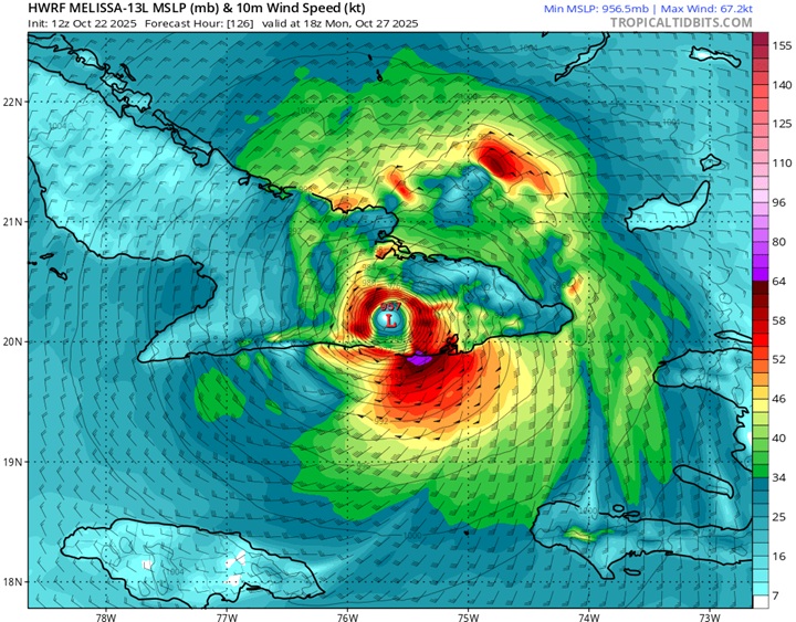
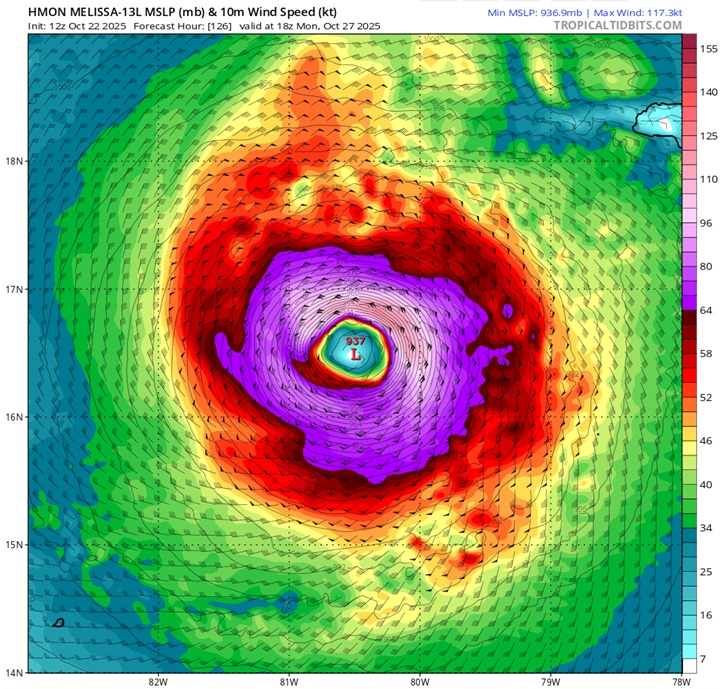
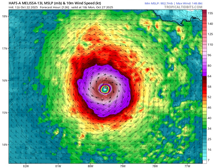
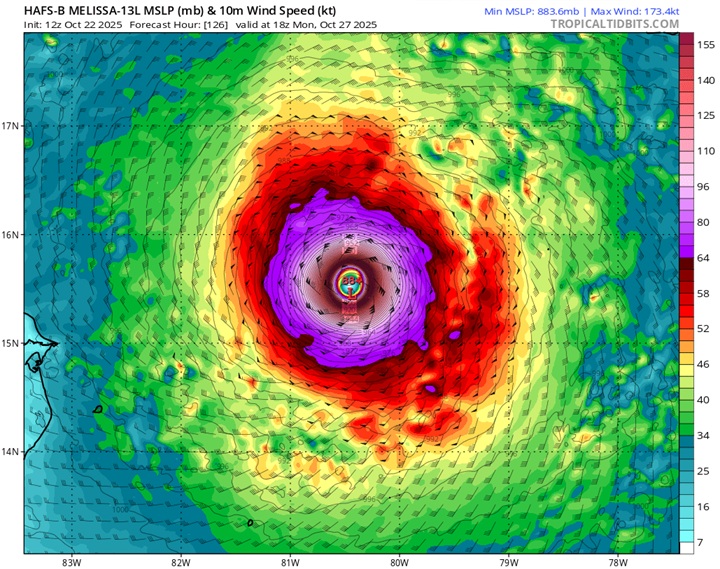
As models have had more and more data to digest and we have had real eyes on the ground, so to speak, here are today's 12Z DeepMind FNV3 ensembles out to 240 hours (10 days), as well as the hurricane models (HWRF, HMON, HAFS-A and HAFS-B) out to the end of their runs (126 hours).
FNV3 Ensemble members out to 240 hours
HWRF for Monday Oct 27 18Z
HMON for Monday Oct 27 18Z
HAFS-A for Monday Oct 27 18Z
HAFS-B for Monday Oct 27 18Z
|
MikeC
Admin
Reged:
Posts: 4811
Loc: Orlando, FL
|
|
Another day of highly sheared system, it's on the edge of getting pushed up like the is showing, but ultimately won't head that way and go along the track. How intense it gets is only limited by the shape it gets in. Tomorrow or so that shear starts to let up, so it'll probably slowly strengthen at first and ramp up when the shear is gone and the outflow gets ventilated by it instead. UKMet keeps it weak, though. Models probably will fluctuate some more, and the tTrack is still variant, but the 's is probably the best weighted.
|
cieldumort
Moderator
Reged:
Posts: 2656
Loc: Austin, Tx
|
|
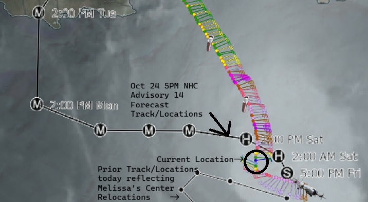
Melissa is not done disobeying forecast, apparently. Potentially preparing to enter RI overnight, and now a bit west of forecast.
Fine-turning the next few days is academic, to a point. The big picture is of a catastrophic tropical cyclone in the Caribbean, near-term, that also could track across the Bahamas into the eastern seaboard and/or eastern Canada, long-term. Sometimes these granular near-term twists and turns will ultimately have outsized influence on the longer-term track and intensity, however.
|
Robert
Weather Analyst

Reged:
Posts: 371
Loc: Southeast, FL
|
|
Back in 2016 Ukmet was the outlier west, east with hurricane Mathew euro middle. Then they all swinged west once movement began, the trough didFriday. Not dig as strong and the ridging was stronger.
12Z Ukmet still very much further west. Still down in northwest carribean friday.
Edited by Robert (Fri Oct 24 2025 09:04 PM)
|
cieldumort
Moderator
Reged:
Posts: 2656
Loc: Austin, Tx
|
|
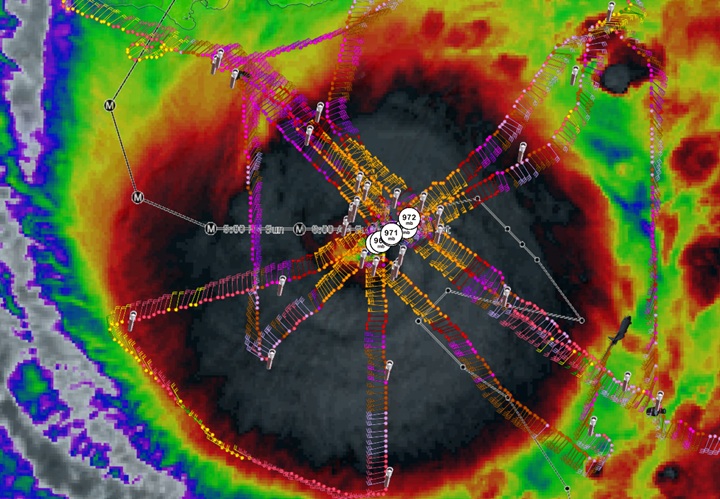
VDM 19 10-25-25-0301z
For intents and purposes, over the past few hours Melissa has been drifting southwest, although the 11PM Advisory holds her track as westbound.
The longer Melissa tracks southwest, potentially the higher upside to her wind and downside to her minimum pressure, as conditions are even more favorable to the southwest of her presently already exceptionally favorable location for RI.
While this is not officially forecast and unlikely to persist for much longer, it is worth keeping an eye on. Such a development has been something I've considered possible for a while.
|
cieldumort
Moderator
Reged:
Posts: 2656
Loc: Austin, Tx
|
|
Some good news, at least for the eastern seaboard, with last night's 0z ensembles from , and Google's DeepMind: Not a single ensemble member out of well over 100 now suggests a bend back towards New England/Canada is even remotely possible.
|
OrlandoDan
Weather Master

Reged:
Posts: 458
Loc: Longwood, FL
|
|
I know Mellisa is far from the Orlando area and is far from expexted to reach here, but are we currently experiecing a Predecessor Rain Event (PRE) here at 16:38 EDT on 10/26/2025?
--------------------
Keith (1988), Charley (2004), Frances (2004) , Jeanne (2004), Fay (2008), Mathew (2016), Irma (2017), Dorian (2019)
Personal Weather Station: https://www.wunderground.com/dashboard/pws/KFLLONGW67
|


 Threaded


