cieldumort
Moderator

Reged:
Posts: 2738
Loc: Austin, Tx
|
|
6:00PM EDT 24 October 2025 Update
Melissa has a chance to intensify rapidly enough to track further west upon feeling the new steering currents, but would be doing so from a point now further east than forecast, due to center relocations earlier today. As a result, the 5PM Advisory now has Melissa, as a borderline Cat 5, tracking directly across Jamaica.
It is important to stress that even if a direct path across Jamaica does not occur, Melissa's increased size and slow forward speed will almost certainly result in profoundly catastrophic flash flooding and mudslides, regardless of the maximum wind speeds on land. Preparations to protect life and property from flooding and mudslides should be every bit as important as protecting from the wind.
NHC:Quote:
Key Messages:
1. Jamaica: Due to Melissa’s slow motion, a prolonged multi-day period of damaging winds and heavy rainfall resulting in potentially catastrophic flash flooding and numerous landslides is likely to begin late Saturday or Sunday. There is an increasing risk of life-threatening storm surge when the center of Melissa nears Jamaica early next week. Preparations to protect life and property should be rushed to completion.
2. Haiti: Heavy rainfall will result in catastrophic flash flooding and landslides across southwestern Haiti into early next week. Extensive damage to roads and buildings is expected, potentially isolating communities for an extended period of time. Immediate preparations to protect life and property should be taken. Strong winds could also potentially last for a day or more over the Tiburon peninsula of Haiti.
3. Dominican Republic: Heavy rainfall could produce potentially catastrophic flash flooding and numerous landslides in southern portions of the Dominican Republic.
4. Eastern Cuba and Bahamas: Interests in Cuba and the Bahamas should monitor the progress of Melissa since there is an increasing risk of significant storm storm surge, damaging winds, and heavy rainfall by the middle of next week. The risk of life-threatening flash flooding and landslides in eastern Cuba are increasing.
Ciel
2:00AM EDT 24 October 2025 Update
The forecast for Melissa is one of the trickiest and least straight forward the has had to do in quite some time. Even with multiple recon missions, so many competing forces and variables being at play have made certain details of lower confidence. However, what is not of low confidence, is that Melissa is not a tropical cyclone to roll the dice on. Taking a personal liberty here to ask our friends in and around Jamaica and Haiti to do everything possible to prepare for the worst and hope for the best. The potential for Melissa to become one of the most catastrophic hurricanes in the Atlantic basin so far this century can not be overstated.
Ciel
11:30PM EDT 23 October 2025 Update
Tropical Storm Melissa is forecast to make a multi-day major blow to Jamaica, with a fairly grim forecast that would impact the island with mulltiple days of extremely heavy rain, winds, and storm surge, across the entire island, and with most of the surge being on the south side of the island. (entire length of it) Those there please take it seriously.
the key messages states it best. Due to Melissa’s slow motion, the risk of a prolonged multi-day period of potentially damaging winds, heavy rainfall resulting in life-threatening flash flooding and numerous landslides, and storm surge continues to increase for Jamaica. Preparations to protect life and property should be rushed to completion, since strong winds and flooding rains could begin in Jamaica by Saturday.
Beyond this, eastern Cuba, including Guantanamo bay, and the Bahamas will need to watch, as well as eventually Bermuda.
2:30PM EDT 22 October 2025 Update
Melissa has once again proceeded west, which puts the center effectively a little southwest of where it was expected at this time, and would have to
shoot a touch northeast to realign, which is possible with a center jump, but until then, once again, Melissa is southwest of forecast.Quote:
At 200 PM EDT (1800 UTC), the center of Tropical Storm Melissa was located by Air Force Reserve reconnaissance aircraft near latitude 14.3 North, longitude 74.0 West. Melissa is moving slowly toward the west near 2 mph (4 km/h). (NHC)
The chance for the quicker northeast across Hispaniola and out-to-sea track continues diminishing, with the risk of a meander in the central-western Caribbean and becoming a high-end Major hurricane, producing rounds and rounds of rainfall for affected nearby landmasses, increasing.
Ciel
11:00AM EDT 22 October 2025 Update
Melissa is now officially forecast to become a Major Hurricane, and very slow moving, in the central to western Caribbean. Interests in this region should begin considering taking necessary precautions to protect life and property, as this set up is particularly conducive to a high-end tropical cyclone that gets its name retired.
Ciel
10:30AM EDT 21 October 2025 Update
Invest 98L has become Tropical Storm Melissa
WATCHES AND WARNINGS
A Hurricane Watch has been issued for the southern peninsula of Haiti from the border with the Dominican Republic to Port-Au-Prince. The government of Jamaica has issued a Tropical Storm Watch for the island.
Ciel
2:30AM EDT 21 October 2025 Update
Advisories are expected to begin at any time today for either Potential Tropical Cyclone, or more likely still, Tropical Storm Melissa.
WARNINGS
...CARIBBEAN GALE WARNING...
Caribbean within 15N68W to 15N69W to 15N70W to 14N68W to 15N68W E to SE winds 30 to 35 KT. Seas 2.5 to 3.0 M.
The Meteorological Service of Jamaica has issued a Severe Weather Alert for the entire island, effective until 5 p.m. on Thursday.
Ciel
8:00PM EDT 20 October 2025 Update
NHC has increased their 2-day development probability that 98L becomes a TC to 90%. Watches and Warnings for locations in the Caribbean could be coming as soon as overnight tonight. Regardless of imminent Watches/Warnings, portions of the ABC Islands can expect heavy rain and strong wind gusts the next few days. Puerto Rico, Hispaniola, Jamaica and Cuba could be looking at even more significant impacts, including the possibility of extreme rainfall totals and very high winds by mid to late week.
The next name on the list this year is Melissa. There is a very real possibility that this system, should it become Melissa as is very likely, gets retired. Interests around the Caribbean should begin considering paying very close attention, monitoring reliable local advisories and forecasts, and keeping abreast of updates from the National Hurricane Center.
Ciel
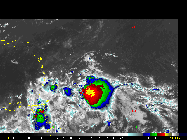
1:45AM EDT 19 October 2025 Update
Invest 98L appears to be ramping up tonight.
During the last few frames of daylight satellite imagery, a little LLC could be seen, which could also now be getting nestled underneath persistent deep convection. Additionally, recent scatterometer data shows surface winds likely gusting well into tropical storm force in portions of its eastern side.
Interests in the Lesser Antilles may want to consider making some initial preps for what could be a very stout wave, or even perhaps, if the wave can close off prior to or during passage into the Caribbean, a bona fide tropical storm. TC genesis still looks much more possible once it is in the central to western Caribbean owing to its current fast forward speed, but the chance of development prior to reaching the Caribbean may be going up.
Ciel
Original Update
With occluding fronts rolling into the subtropics and tropical waves still rolling into the tropics, opportunities for development continue into the second half of this back-loaded 2025 Atlantic Hurricane Season. One silver lining, climatology increasingly disfavors mainland US landfalls from October on. However, this is not the case for locations in and around the Caribbean, nor for Bermuda, and systems are still deserving to be watched.
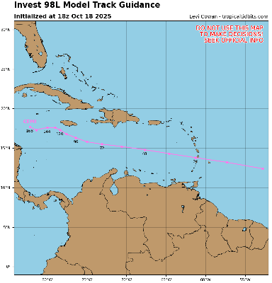
The most impressive wave of two we have been tracking for some time now has just been Invest tagged, 98L. The wave ahead of it also has a chance to develop, but appears to be less than 98's. Interests in and around the Caribbean may want to begin paying closer attention to both of these waves.
Model deep dives and speculation on 98L/Melisssa: Melissa Forecast Lounge
Jamaica Live Cameras
Timelapses and more from Jamiaca
Jamaica Power Outage map
Edited by cieldumort (Fri Oct 24 2025 06:11 PM)
|
cieldumort
Moderator
Reged:
Posts: 2738
Loc: Austin, Tx
|
|
Upcoming scheduled recon missions
Location: 14.8N, 71.4W
Depart time: 21/1645Z
Entry time: 21/1730Z
Fix time: 21/1800Z
Exit time: 21/2230Z
Altitude: SFC TO 10,000
Mission Type: LOW-LEVEL INVEST
Location: 15.3N, 72.6W
Depart time: 22/0500Z
Entry time: 21/2230Z
Fix time: 22/0600Z
Exit time: NA
Altitude: SFC TO 10,000 FT
Mission Type: SYSTEM SURVEY
Location: 15.6N, 73.2W
Depart time: 22/1015Z
Entry time: 22/1100Z
Fix time: 22/1130Z,1730Z
Exit time: 22/1730Z
Altitude: SFC TO 10,000
Mission Type: FIX
|
CFHC

Reged:
Posts: 211
Loc: East Central Florida
|
|
recording up for Jamaica radar here
https://flhurricane.com/imageanimator.php?960
|
CFHC
Reged:
Posts: 211
Loc: East Central Florida
|
|
Added a handful of webcam timelapse captures to https://flhurricane.com/cyclone/animationlist.php?year=all&tag=Melissa+%282025%29
|
cieldumort
Moderator
Reged:
Posts: 2738
Loc: Austin, Tx
|
|
Melissa has seen several center relocations over the past few days. This morning, several more recentered the cyclone further into the deep convection, to the southeast of forecast locations.
Most recent recon data combined with most recent microwave imagery suggests that an inner core may now be forming within the deep convection. Melissa has responded, with maximum sustained winds of about 60 MPH and pressure now down to about 999mb.
The chapter of Melissa's intensification has begun, and has done so a little bit south and east of where it was expected to commence. This may have some implications for duration over water (probably longer) and how much the cyclone feels and responds to changing steering currents building in from her north (possibly ultimately ending up a little west or west-southwest of where progged for 72-96 hours, as just one potential outcome).
|
cieldumort
Moderator
Reged:
Posts: 2738
Loc: Austin, Tx
|
|
Product: NOAA Vortex Message (URNT12 KWBC)
Transmitted: 24th day of the month at 23:03Z
Agency: National Oceanic and Atmospheric Administration (NOAA)
Aircraft: Lockheed WP-3D Orion (Reg. Num. N42RF)
Storm Name: Melissa
Storm Number & Year: 13 in 2025 (flight in the North Atlantic basin)
Mission Number: 9
Observation Number: 05
A. Time of Center Fix: 24th day of the month at 22:35:51Z
B. Center Fix Coordinates: 16.14N 74.69W
B. Center Fix Location: 191 statute miles (308 km) to the SE (133°) from Kingston, Jamaica.
C. Minimum Height at Standard Level: Not Available
D. Minimum Sea Level Pressure: 993mb (29.33 inHg)
E. Dropsonde Surface Wind at Center: From 225° at 3kts (From the SW at 3mph)
F. Eye Character: Open in the northwest
G. Eye Shape: Elliptical (oval shaped)
|
|


 Threaded


