CFHC

Reged:
Posts: 207
Loc: East Central Florida
|
|
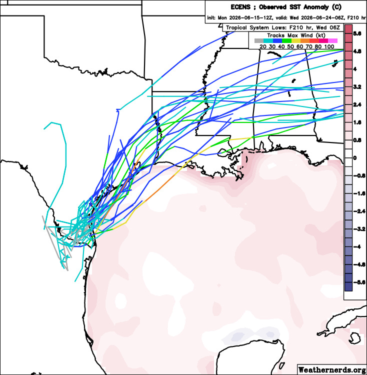
Euro ensembles very active with 90L here. Vort chart isn't showing it well since the rotation is so small, at least not yet.
Beyond these Ensembles, the keeps it over land, however icon, AI , Canadian do bring it out over the water. The 50/50 seems like a good estimate. Its window to strengthen is short, but the pattern may allow it (with a lot of baroclinic enhancement)
|
cieldumort
Moderator

Reged:
Posts: 2705
Loc: Austin, Tx
|
|
If 90L does become a Tropical Cyclone, the only noticeably different impact could just be a greater chance of a more consolidated, maximized area of heaviest rainfall ~ but not necessarily the highest totals, as these can be achieved without core rains given the likelihood of ongoing training bands of rain/thunderstorms and the squeezing out of moisture as this system interacts with the impinging front to its north.
Given how saturated both the ground and air is or is becoming in the southern states, combined with strong upper-level exhaust, it may maintain as a Tropical Cyclone for quite a lot longer than expected. Alternatively, it could also encounter too much shear and shred apart. But one thing is certain: flooding.

|
cieldumort
Moderator
Reged:
Posts: 2705
Loc: Austin, Tx
|
|
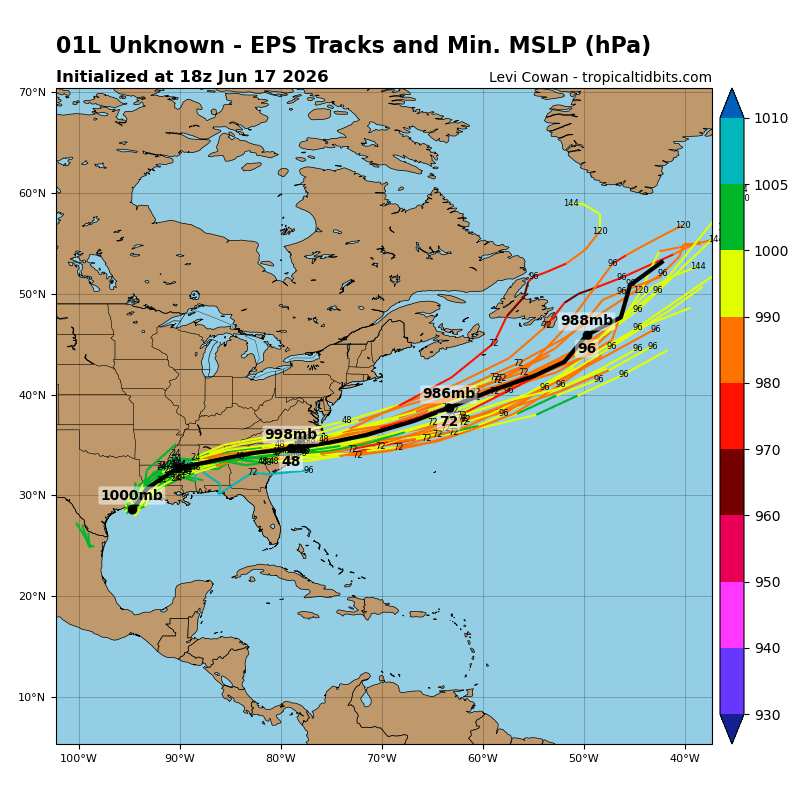
After curving more east than north for a while, now PTC ONE is being forecast to take a more northeasterly track, going just barely offshore along the Texas coast.
If a track just offshore of most of if not the entirety of the Texas coastline verifies, ONE would likely have sufficient time over water to be able to organize into
Arthur. This would also lead to several days of additional deep tropical moisture being rotated around the Low into the south.
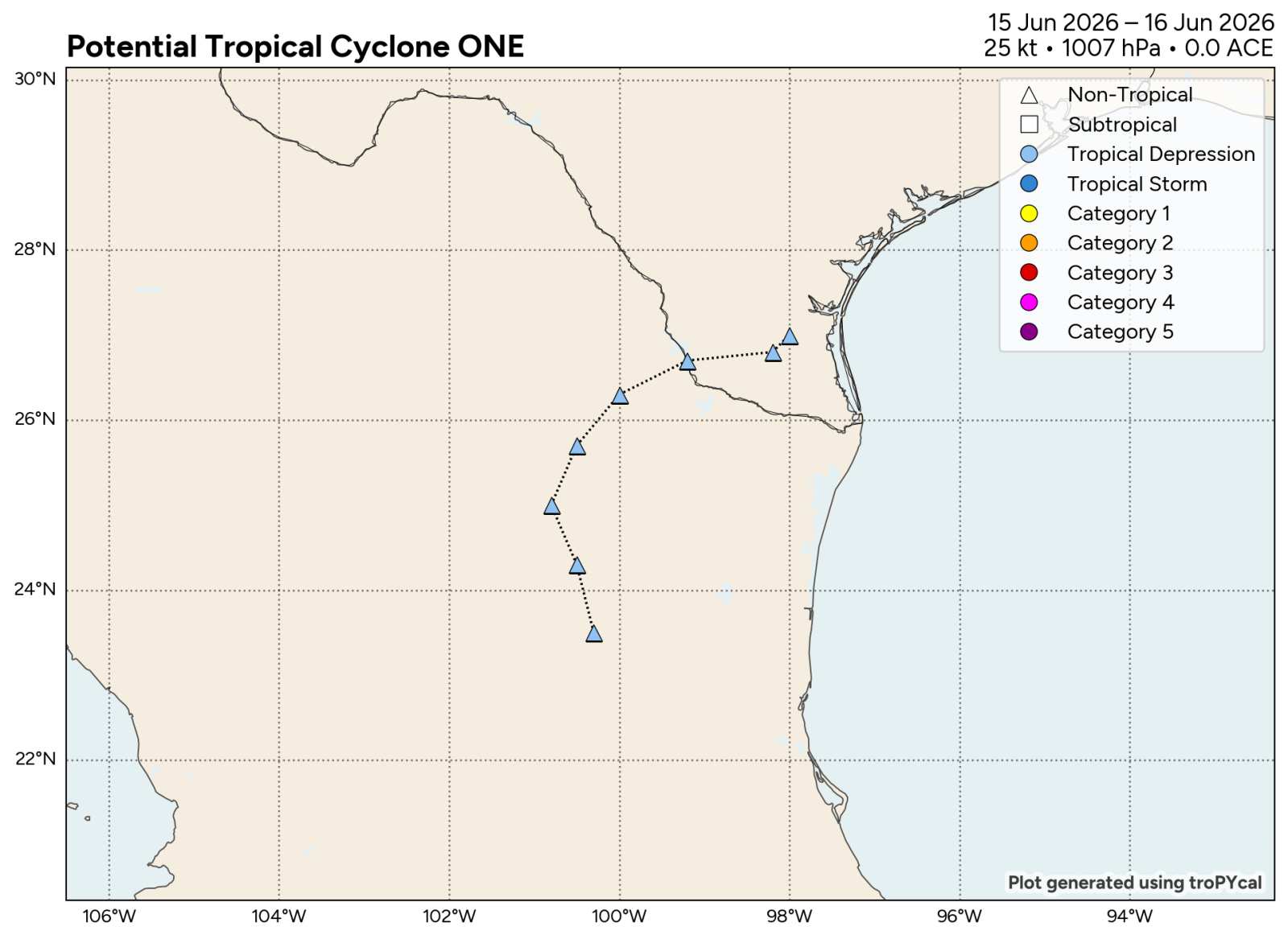
Above: PTC ONE Track History Image credit: Polarwx.com
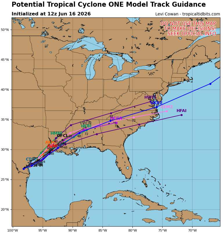
Above: Track Guidance image credit: TropicalTidbits.com
|
cieldumort
Moderator
Reged:
Posts: 2705
Loc: Austin, Tx
|
|
Deep-layer shear is starting to impinge quite a bit on the western side of ONE. It is going to need to move out over the warm gulf water soon so it can have its best chance to develop the deep convection needed to fend it off and begin moving more with the flow so that shear is reduced, especially if a good upper-level outflow channel can develop.
|
cieldumort
Moderator
Reged:
Posts: 2705
Loc: Austin, Tx
|
|

|
cieldumort
Moderator
Reged:
Posts: 2705
Loc: Austin, Tx
|
|
Not much in the way of convection as ONE enters the Gulf
|
cieldumort
Moderator
Reged:
Posts: 2705
Loc: Austin, Tx
|
|
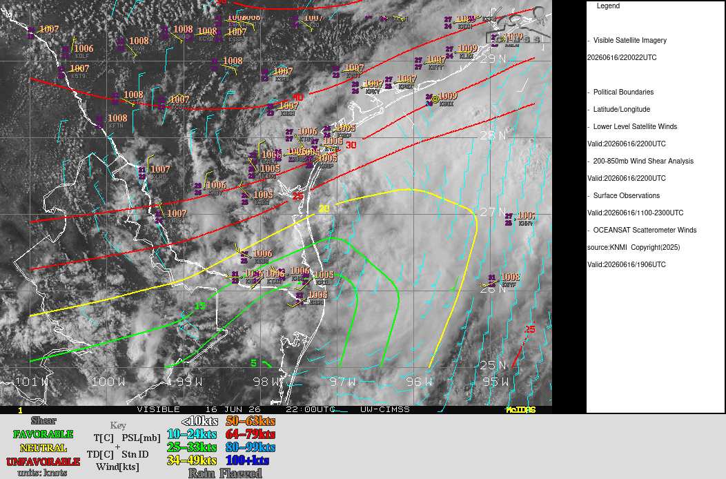
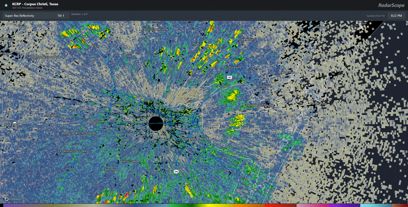
ONE is presently a very sheared cyclone and it may come down to a subjective call as to whether or not to classify it as a Tropical Cyclone this morning, but it seems a close call despite how lousy it looks.
The western semicircle is sheared and exposed with dry air and subsidence. On the other hand, banding has arguably improved in appearance on radar, and while most bands are well east of the center, which is still right on the coast around Corpus Christi, TX, several already are likely producing tropical storm force winds. Furthermore, in the aggregate, models continue supporting further development, with some even suggesting that ONE may become a robust hybrid once back over land, producing a massive swath of heavy and locally flooding rain, at least isolated damaging wind gusts, and potentially several tornadoes and waterspouts.
METAR KGYF 170736Z AUTO 13025G44KT 1 1/4SM -TSRA BR OVC008 24/22 A2969 RMK AO2 LTG DSNT ALQDS T02380222
METAR KGYF 170715Z AUTO 17041KT 7SM -TSRA SCT014 BKN029 OVC043 26/25 A2968 RMK AO2 LTG DSNT ALQDS T02600248
METAR KGYF 170655Z AUTO 17030G35KT 5SM -TSRA BR SCT011 BKN022 OVC036 25/23 A2971 RMK AO2 LTG DSNT ALQDS P0003 T02540234
METAR KGYF 170635Z AUTO 17027G35KT 1 3/4SM TS SCT007 BKN026 OVC038 26/23 A2974 RMK AO2 LTG DSNT ALQDS PWINO T02580230
METAR KGYF 170615Z AUTO 19032G41KT 7SM -TSRA SCT007 BKN038 OVC043 27/25 A2973 RMK AO2 LTG DSNT ALQDS T02730245
METAR KGYF 170555Z AUTO 19031G34KT 5SM -TSRA BR SCT007 SCT014 BKN028 28/26 A2971 RMK AO2 LTG DSNT ALQDS P0016 T02790259 10329 20276 60162
METAR KGYF 170535Z AUTO 17017KT 7SM -TSRA BR BKN005 BKN017 OVC060 28/26 A2973 RMK AO2 LTG DSNT ALQDS P0016 T02770255
METAR KGYF 170515Z AUTO 19025G29KT 5SM -TSRA BR OVC005 31/29 A2972 RMK AO2 LTG DSNT ALQDS P0016 T0306////
METAR KGYF 170455Z AUTO 25020G49KT 210V290 1 1/4SM +TSRA BR OVC005 29/26 A2972 RMK AO2 VIS 1/2V2 1/2 LTG DSNT ALQDS P0140 T02850262

|
cieldumort
Moderator
Reged:
Posts: 2705
Loc: Austin, Tx
|
|
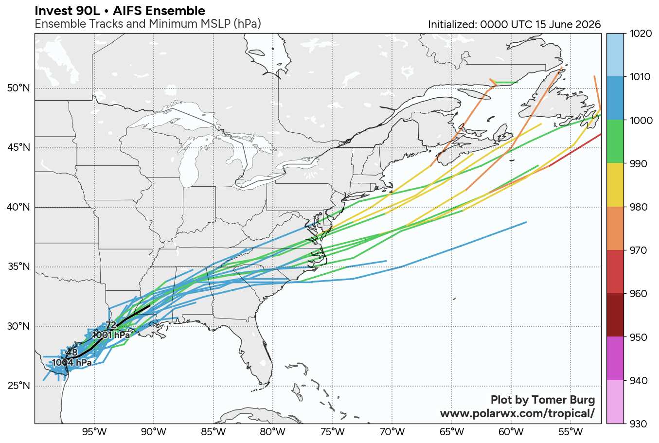
Overall, several of the more traditional models' ensembles, such as the EURO's EPS, performed fairly well and arguably better than the GDM (Google DeepMind) with regard to both development and intensity. GDM had only a very few of its ensemble members showing development at all. However, of the GDM members that did, they performed far better than traditionals for where genesis would occur.
As for future track and intensity, here are a few of the most recent runs (Images and plots credit: polarwx.com):


|
cieldumort
Moderator
Reged:
Posts: 2705
Loc: Austin, Tx
|
|
We may be starting to see some center reformations that could track with the most recent GDM ensemble run from 12Z

|
cieldumort
Moderator
Reged:
Posts: 2705
Loc: Austin, Tx
|
|
|
cieldumort
Moderator
Reged:
Posts: 2705
Loc: Austin, Tx
|
|
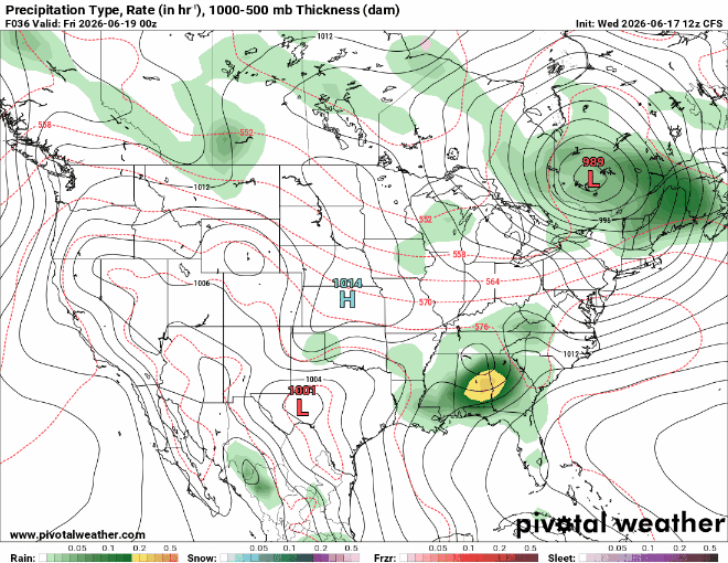
Modeling for Thursday evening (6-19-26-0z). Arthur or Arthur's remnants still producing significant weather.
|
cieldumort
Moderator
Reged:
Posts: 2705
Loc: Austin, Tx
|
|
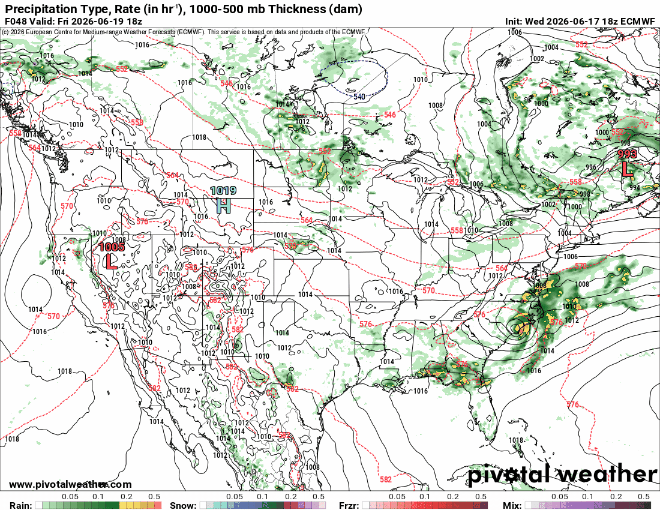
Modeling for midday Friday (6-19-26-18z). Arthur/Arthur's remnants entering western Atlantic. May be redeveloping.
|


 Threaded

 [Re:
[Re: 

