cieldumort
Moderator

Reged:
Posts: 2949
Loc: Austin, Tx
|
|
8AM HST 7 September, 2026 Update
The Tropical Storm Watch for Oahu has been upgraded to a Warning as Lowell continues tracking substantially right of official forecast and model guidance and the odds that Hurricane Lowell leads to significant impacts across all of Hawaii are going way up. Efforts to protect life and property from flooding state-wide and wind in the west and also on higher elevations should be getting rushed to completion.
Ciel
Original Update
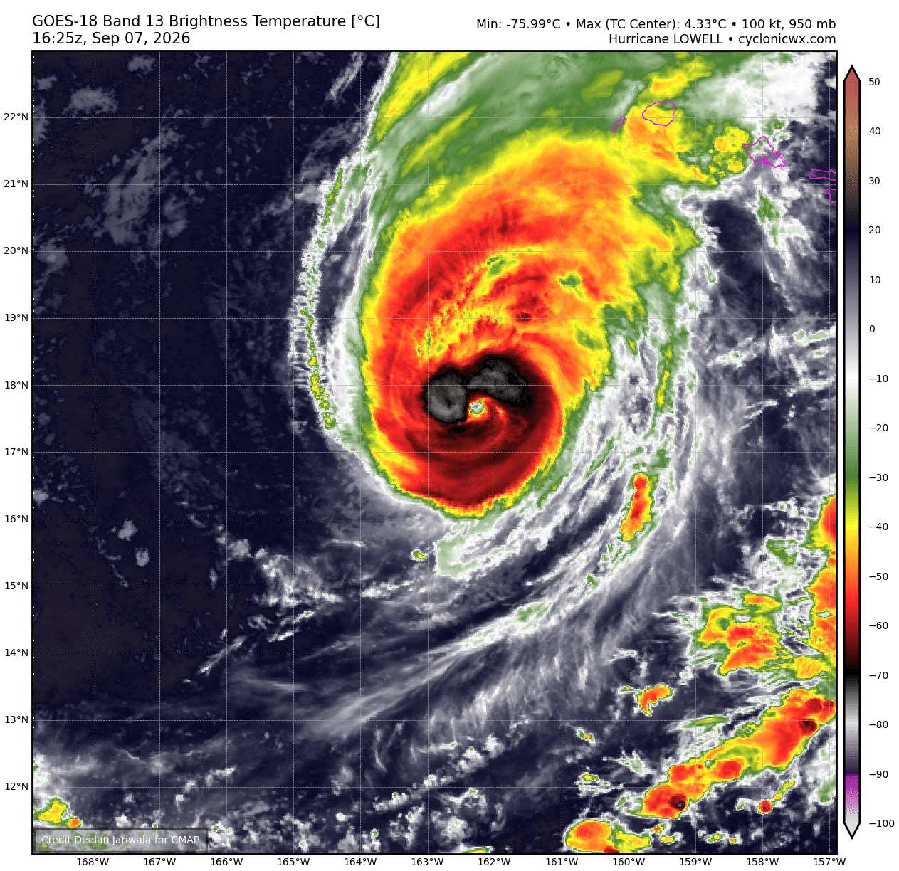
Above: Major Hurricane Lowell while tracking north-northeast towards Hawaii. Credits: Deelan Jariwala and cyclonicwx.com
With the exception of home-grown Edouard sneaking past many models to become a formidable tropical storm in the western Gulf, the Atlantic basin has otherwise been incredibly quiet so far during the heart of hurricane season. This is not the case in the Pacific with yet another hurricane heading towards the great state of Hawaii.
As of Sunday September 7, 2026 500 AM HST, Hurricane Lowell was located near 17.5N 162.6W, now tracking north-northeast around 14 mph. Hurricane Warnings are now up for Kauai County, including the islands of Kauai and Niihau and also the Papahanaumokuakea Marine National Monument from Nihoa to French Frigate Shoals. A Tropical Storm Watch has been issued for Oahu.
Lowell is a formidable hurricane and still a Major as of this update. The hurricane has been a Category 5 and despite 'weakening' in quotes, much of this energy does not rapidly go away with the decrease in category and interests in the hurricane warned portions of western Hawaii should begin rushing preparations to protect life and property to completion.
Lowell is producing impacts over a large area and the Big Island of Hawaii, even miles and miles away from the center, will likely experience flash flooding yet again. Some flooding has already begun from Lowell across the islands.
An additional 6 to 10 inches for Kauai, is forecast, locally 16 inches possible. For the Big Island, 4 to 8 inches of rain likely, locally up to 12 inches. Oahu and Maui counties can expect up to 8 inches, also locally higher.
We have Lounge two threads for Lowell ongoing in the Forums (Other Basins - General discussion) and a (Lounge - More modeling)
Edited by cieldumort (Mon Sep 07 2026 02:06 PM)
|
cieldumort
Moderator
Reged:
Posts: 2949
Loc: Austin, Tx
|
|
Three VDMs so far out of the 10th mission into Lowell
The most recent confirms that Lowell may now, recently has been or could soon be Cat 4 again
Product: Air Force Vortex Message (URPN12 KNHC)
Transmitted: 7th day of the month at 20:25Z
Agency: United States Air Force
Aircraft: Lockheed WC-130J Hercules with reg. number AF97-5303
Storm Name: Lowell
Storm Number & Year: 12 in 2026 (flight in the Northeast Pacific basin)
Mission Number: 10
Observation Number: 24
A. Time of Center Fix: 7th day of the month at 19:36:40Z
B. Center Fix Coordinates: 18.40N 162.04W
B. Center Fix Location: 302 statute miles (486 km) to the SW (215°) from Lihue, on the island of Kauai, HI, USA.
C. Minimum Height at Standard Level: 2,750m (9,022ft) at 700mb
D. Minimum Sea Level Pressure: 956mb (28.23 inHg)
E. Dropsonde Surface Wind at Center: From 130° at 13kts (From the SE at 15mph)
G. Eye Shape: Not Available
H. Estimated (by SFMR or visually) Maximum Surface Wind Inbound: 118kts (135.8mph)
I. Location & Time of the Estimated Maximum Surface Wind Inbound: 40 nautical miles (46 statute miles) to the W (261°) of center fix at 19:24:30Z
J. Maximum Flight Level Wind Inbound: From 17° at 82kts (From the NNE at 94.4mph)
K. Location & Time of the Maximum Flight Level Wind Inbound: 28 nautical miles (32 statute miles) to the WSW (258°) of center fix at 19:28:00Z
L. Estimated (by SFMR or visually) Maximum Surface Wind Outbound: 123kts (141.5mph)
M. Location & Time of the Estimated Maximum Surface Wind Outbound: 28 nautical miles (32 statute miles) to the E (84°) of center fix at 19:46:00Z
N. Maximum Flight Level Wind Outbound: From 179° at 113kts (From the S at 130.0mph)
O. Location & Time of the Maximum Flight Level Wind Outbound: 45 nautical miles (52 statute miles) to the E (87°) of center fix at 19:51:30Z
P. Maximum Flight Level Temp & Pressure Altitude Outside Eye: 9°C (48°F) at a pressure alt. of 3,044m (9,987ft)
Q. Maximum Flight Level Temp & Pressure Altitude Inside Eye: 18°C (64°F) at a pressure alt. of 3,055m (10,023ft)
R. Dewpoint Temp (collected at same location as temp inside eye): 13°C (55°F)
R. Sea Surface Temp (collected at same location as temp inside eye): Not Available
S. Fix Determined By: Penetration, Wind and Pressure
S. Fix Level: 700mb
T. Navigational Fix Accuracy: 0.02 nautical miles
T. Meteorological Accuracy: 1 nautical mile
|
cieldumort
Moderator
Reged:
Posts: 2949
Loc: Austin, Tx
|
|
Product: Air Force Vortex Message (URPN12 KNHC)
Transmitted: 7th day of the month at 21:37Z
Agency: United States Air Force
Aircraft: Lockheed WC-130J Hercules with reg. number AF97-5303
Storm Name: Lowell
Storm Number & Year: 12 in 2026 (flight in the Northeast Pacific basin)
Mission Number: 10
Observation Number: 35
A. Time of Center Fix: 7th day of the month at 21:12:10Z
B. Center Fix Coordinates: 18.82N 161.91W
B. Center Fix Location: 274 statute miles (440 km) to the SW (217°) from Lihue, on the island of Kauai, HI, USA.
C. Minimum Height at Standard Level: 2,745m (9,006ft) at 700mb
D. Minimum Sea Level Pressure: 958mb (28.29 inHg)
E. Dropsonde Surface Wind at Center: From 105° at 18kts (From the ESE at 21mph)
F. Eye Character: Not Available
G. Eye Shape: Not Available
H. Estimated (by SFMR or visually) Maximum Surface Wind Inbound: 121kts (139.2mph)
I. Location & Time of the Estimated Maximum Surface Wind Inbound: 8 nautical miles to the NNW (347°) of center fix at 21:09:30Z
J. Maximum Flight Level Wind Inbound: From 96° at 112kts (From the E at 128.9mph)
K. Location & Time of the Maximum Flight Level Wind Inbound: 27 nautical miles (31 statute miles) to the N (356°) of center fix at 21:03:30Z
L. Estimated (by SFMR or visually) Maximum Surface Wind Outbound: 98kts (112.8mph)
M. Location & Time of the Estimated Maximum Surface Wind Outbound: 42 nautical miles (48 statute miles) to the S (176°) of center fix at 21:25:30Z
N. Maximum Flight Level Wind Outbound: From 264° at 97kts (From the W at 111.6mph)
O. Location & Time of the Maximum Flight Level Wind Outbound: 41 nautical miles (47 statute miles) to the S (176°) of center fix at 21:25:00Z
P. Maximum Flight Level Temp & Pressure Altitude Outside Eye: 8°C (46°F) at a pressure alt. of 3,053m (10,016ft)
Q. Maximum Flight Level Temp & Pressure Altitude Inside Eye: 16°C (61°F) at a pressure alt. of 3,061m (10,043ft)
R. Dewpoint Temp (collected at same location as temp inside eye): 14°C (57°F)
R. Sea Surface Temp (collected at same location as temp inside eye): Not Available
S. Fix Determined By: Penetration, Wind, Pressure and Temperature
S. Fix Level: 700mb
T. Navigational Fix Accuracy: 0.02 nautical miles
T. Meteorological Accuracy: 1 nautical mile
Remarks Section:
Maximum Flight Level Wind: 113kts (~ 130.0mph) which was observed 45 nautical miles (52 statute miles) to the E (87°) from the flight level center at 19:51:30Z
|
cieldumort
Moderator
Reged:
Posts: 2949
Loc: Austin, Tx
|
|
Product: Air Force Vortex Message (URPN12 KNHC)
Transmitted: 7th day of the month at 23:03Z
Agency: United States Air Force
Aircraft: Lockheed WC-130J Hercules with reg. number AF97-5303
Storm Name: Lowell
Storm Number & Year: 12 in 2026 (flight in the Northeast Pacific basin)
Mission Number: 10
Observation Number: 44
A. Time of Center Fix: 7th day of the month at 22:36:40Z
B. Center Fix Coordinates: 19.09N 161.71W
B. Center Fix Location: 251 statute miles (404 km) to the SW (217°) from Lihue, on the island of Kauai, HI, USA.
C. Minimum Height at Standard Level: 2,759m (9,052ft) at 700mb
D. Minimum Sea Level Pressure: 958mb (28.29 inHg)
E. Dropsonde Surface Wind at Center: From 85° at 6kts (From the E at 7mph)
F. Eye Character: Not Available
G. Eye Shape: Not Available
H. Estimated (by SFMR or visually) Maximum Surface Wind Inbound: 106kts (122.0mph)
I. Location & Time of the Estimated Maximum Surface Wind Inbound: 34 nautical miles (39 statute miles) to the SE (142°) of center fix at 22:26:00Z
J. Maximum Flight Level Wind Inbound: From 217° at 114kts (From the SW at 131.2mph)
K. Location & Time of the Maximum Flight Level Wind Inbound: 42 nautical miles (48 statute miles) to the SE (141°) of center fix at 22:23:30Z
L. Estimated (by SFMR or visually) Maximum Surface Wind Outbound: 118kts (135.8mph)
M. Location & Time of the Estimated Maximum Surface Wind Outbound: 34 nautical miles (39 statute miles) to the E (82°) of center fix at 22:48:00Z
N. Maximum Flight Level Wind Outbound: From 186° at 131kts (From the S at 150.8mph)
O. Location & Time of the Maximum Flight Level Wind Outbound: 39 nautical miles (45 statute miles) to the E (83°) of center fix at 22:49:30Z
P. Maximum Flight Level Temp & Pressure Altitude Outside Eye: 15°C (59°F) at a pressure alt. of 3,046m (9,993ft)
Q. Maximum Flight Level Temp & Pressure Altitude Inside Eye: 19°C (66°F) at a pressure alt. of 3,047m (9,997ft)
R. Dewpoint Temp (collected at same location as temp inside eye): 13°C (55°F)
R. Sea Surface Temp (collected at same location as temp inside eye): Not Available
S. Fix Determined By: Penetration, Wind, Pressure and Temperature
S. Fix Level: 700mb
T. Navigational Fix Accuracy: 0.02 nautical miles
T. Meteorological Accuracy: 1.75 nautical miles
Remarks Section:
Maximum Flight Level Wind: 131kts (~ 150.8mph) which was observed 39 nautical miles (45 statute miles) to the E (83°) from the flight level center at 22:49:30Z
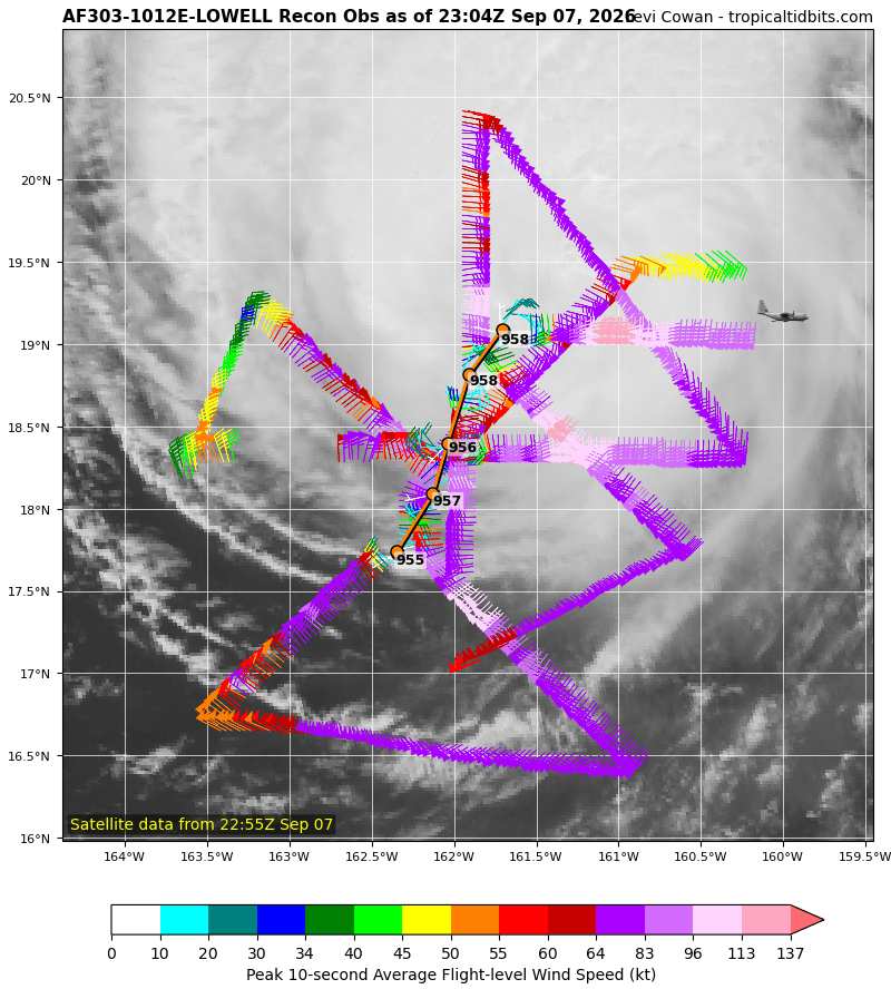
An 80% reduction ratio from FLW to the surface continues to suggests that Lowell may be Cat 4. This is further backed up by the SFMR - Ciel
|
cieldumort
Moderator
Reged:
Posts: 2949
Loc: Austin, Tx
|
|
Saffir-Simpson is a wind speed hierarchy, not barometric pressure. Recon keeps finding stronger winds within Lowell despite a slight rise in min central pressure.
|
cieldumort
Moderator
Reged:
Posts: 2949
Loc: Austin, Tx
|
|
These SFMR surface wind readings at or above Cat 3 are not flagged for rain contamination
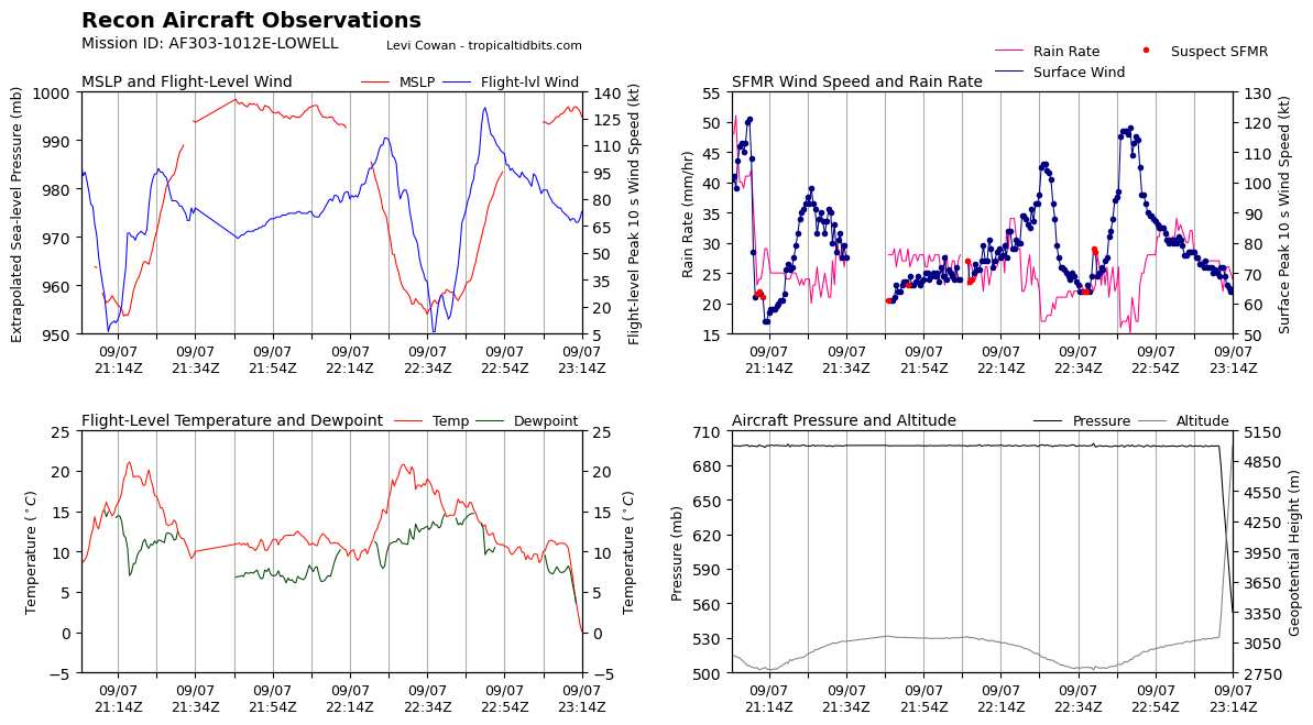
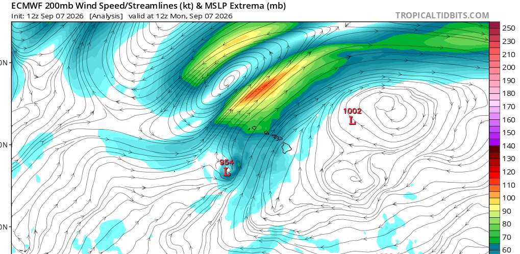
The wind field is likely undergoing some changes with height in response to interacting with the upper-level low to Lowell's north-northwest. Even if these winds are not occurring sustained at sea-level (SFMR and reduction ratio suggests that they may be), they are likely still occurring at higher elevations and could pose a very serious wind damage and life-safety risk on the higher elevations of the Hawaiian islands.
|
cieldumort
Moderator
Reged:
Posts: 2949
Loc: Austin, Tx
|
|
A Tornado Watch has been issued for Kauai County and nearby waters.
THE NATIONAL WEATHER SERVICE HAS ISSUED TORNADO WATCH 1 IN EFFECT
UNTIL 4 AM HST TUESDAY FOR THE FOLLOWING AREAS
IN HAWAII THIS WATCH INCLUDES 1 COUNTY
KAUAI
THIS INCLUDES THE CITIES OF LIHUE.
A TORNADO WATCH MEANS CONDITIONS ARE FAVORABLE FOR TORNADOES IN AND CLOSE TO THE WATCH AREA. PERSONS IN THESE AREAS SHOULD BE ON THE LOOKOUT FOR THREATENING WEATHER CONDITIONS AND LISTEN FOR LATER STATEMENTS AND POSSIBLE WARNINGS.
|
cieldumort
Moderator
Reged:
Posts: 2949
Loc: Austin, Tx
|
|
Preliminary Local Storm Report
National Weather Service Honolulu HI
822 PM HST Mon Sep 7 2026
..TIME... ...EVENT... ...CITY LOCATION... ...LAT.LON...
..DATE... ....MAG.... ..COUNTY LOCATION..ST.. ...SOURCE....
..REMARKS..
0735 PM Non-Tstm Wnd Gst 1 ENE Waimea 21.97N 159.66W
09/07/2026 M76 MPH Kauai HI Mesonet
Mesonet station WHGH1 Waimea Heights.
0800 PM Non-Tstm Wnd Gst 1 SE Makaha Valley 21.48N 158.20W
09/07/2026 M73 MPH Honolulu HI Mesonet
Mesonet station 021HE Heco Makaha Valley Rd.
0748 PM Non-Tstm Wnd Gst 3 SSE Waialua 21.53N 158.11W
09/07/2026 M71 MPH Honolulu HI Mesonet
Mesonet station TT916 Kamananui.
0757 PM Non-Tstm Wnd Gst 1 NE Lihue 21.98N 159.34W
09/07/2026 M69 MPH Kauai HI AWOS
AWOS station PHLI Lihue Airport.
0735 PM Non-Tstm Wnd Gst 3 SSW Kokee State Park 22.09N 159.68W
09/07/2026 M67 MPH Kauai HI Mesonet
Mesonet station PLRH1 Puu Lua.
0750 PM Non-Tstm Wnd Gst 1 NNE Nanakuli 21.41N 158.15W
09/07/2026 M61 MPH Honolulu HI Mesonet
Mesonet station 016HE Heco Paakea Rd.
0825 AM Non-Tstm Wnd Gst 7 ESE Kaunakakai 21.07N 156.92W
09/07/2026 M57 MPH Maui HI Mesonet
Mesonet station TT918 Mokolelau 1.
0810 PM Non-Tstm Wnd Gst 2 SSE Waianae 21.43N 158.17W
09/07/2026 M54 MPH Honolulu HI Mesonet
Mesonet station 095HE Heco Paakea Rd.
0629 PM Non-Tstm Wnd Gst 1 E Omao 21.93N 159.47W
09/07/2026 M51 MPH Kauai HI Mesonet
Mesonet station TT929 Weliweli.
0734 PM Non-Tstm Wnd Gst 5 E Mana 22.04N 159.70W
09/07/2026 M50 MPH Kauai HI Mesonet
Mesonet station POPH1 Puu Opae.
|
cieldumort
Moderator
Reged:
Posts: 2949
Loc: Austin, Tx
|
|
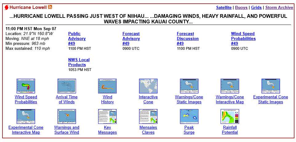
11PM HST Update keeps Lowell at 110 MPH even though it has been 'weakening' for hours and hours. This sort of upholds the position that the hurricane was actually still a Major earlier Monday night. Something to be teased out post-season, perhaps.
|



 Previous
 Index
Index
 Next
Next
 Threaded

 Edit
Edit
 Reply
Reply
 Quote
Quote


