Johncn
Registered User
Reged:
Posts: 4
|
|
Yep. Excellent. Curving more northerly (except the UKMET), and a much better looking result for us. Thanks.
Johncn
|
Hurikid
Verified CFHC User
Reged:
Posts: 14
Loc: Barbados
|
|
Is it just me or does the 06Z run put Bill as a major hurricane heading directly torwards New York City?
|
ftlaudbob
Storm Chaser

Reged:
Posts: 829
Loc: Valladolid,Mx
|
|
Bill continues to look good,very good.Yesterday most of the models had it going very different than they do today.So now we will see what they do over the next few days.Look how the models changed in just 24 hours.A lot going on,a lot to watch.
I am thinking maybe Wednesday we will have a better handle on where Bill is going.
Edited by Ed Dunham (Mon Aug 17 2009 09:36 AM)
|
weathernet
Storm Tracker
Reged:
Posts: 296
Loc: Elsewhere
|
|
Am fascinated how the European model ( often one of the more respected ), had forecasted yesterday a much more "poleward" track than nearly all other models. In fact, given the 500mb data, I would have bet my last dollar that at minimum, this storm would have a 270 degree motion for at least 48 hours. Heck, what would seem to be quite a respectible 594mb heights at the mid levels, would seem to prevent any temporarty change in latitude. Naturally, the orientation of any mid level troughs or high pressure ridges have as much to do with overall motion as well. Here is where the data as we see it reported and spit out by computers, is so important. Forget 7-10 day forecasts, so much importance exists simply for accurate current analysis.
So much for my meteorological diatribe on the importance for proper funding towards the necessary tools to aquire more thorough and accurate data, thus to aid and advance the science of meteorology....
As Bill continues to deepen, I can only imagine that any low level steering influence would become fully irrelevent, and that most models would have a much better handle on future motion. Of course, this has now occured, and much more confidence exists today, than yesterday. This said, is New York or other points on the E. Coast out of the picture yet? I would say no. Recent patterns across the , would seem to have more cut off lows dropping out of Hudson Bay, but only to drop south a little, and then get caught up in a fairly progressive westerly flow. This flow has been shunted fairly north, and there have been less hanging troughs off the Eastern seaboard than in numerious other years. Timing is everything, and Bill could eventually go through substantial deepening and slow down a little, or maintain a slightly more westward track than forecast due to its relative larger size. Point being, that if a weekness does in fact cause Bill to move more northwestward towards the later end of the forecast, if such a weakness pulls up fairly quickly, and strong ridging builds ( or bridges ) over the western Atlantic, than a bend back towards the WNW could ensue. All the more reason that the entire Eastern seaboard need pay attention.
Way to far out for anyone to have much confidence in any forecast. For the moment, my best guess would be a bend back towards the Carolina's. No doubt, i'll be paying a bit more attention to the Euro long range, than most of the other models with this one.
|
MikeC
Admin
Reged:
Posts: 4811
Loc: Orlando, FL
|
|
The today has Bill recurving out to sea, never making landfall as well as whatever forms behind it.
|
ftlaudbob
Storm Chaser

Reged:
Posts: 829
Loc: Valladolid,Mx
|
|
Quote:
The today has Bill recurving out to sea, never making landfall as well as whatever forms behind it.
That would be great news!
I am just waiting to see if that changes by say Wed or Thur.
--------------------
Survived: 10 hurricanes in Rhode Island,Florida and the Yucatan of Mexico .
|
Hurikid
Verified CFHC User
Reged:
Posts: 14
Loc: Barbados
|
|
Bill looks VERY impressive on satellite now......Hurricane at 5 o clock?
|
MikeC
Admin
Reged:
Posts: 4811
Loc: Orlando, FL
|
|
Bill is now a Category 3 hurricane. The most likely scenario is still a recurve, but it's worth watching to see if anything changes.
|
Evan Johnson
Weather Guru

Reged:
Posts: 143
Loc: Loxahatchee, FL
|
|
yeah i agree, anything can happen. im just still waiting for that nothernly turn already.
|
MichaelA
Weather Analyst

Reged:
Posts: 956
Loc: Pinellas Park, FL
|
|
The most recent model runs seem to be tending a bit more westward bringing Bill very close to Cape Cod. If I were there, I'd be beginning preparations for the worst case scenario. Waiting until Saturday is not an option.
--------------------
Michael
PWS
|
doug
Weather Analyst
Reged:
Posts: 1006
Loc: parrish,fl
|
|
You may be correct. It will not take too much of a deviation west to place eastern NE in Jeopardy. The forward speed is already 18 and once the turn occurrs that will increase too. Wasn't it in 1936 or so when a massive cyclone came from nowhere to hit Long Island Rhode Island and Mass.? I think it took about 18 hours to clear from the Bahamas to land fall
--------------------
doug
|
Ed in Va
Weather Master
Reged:
Posts: 489
Loc:
|
|
The infamous LI Express, moving at 70 mph
http://www2.sunysuffolk.edu/mandias/38hurricane/weather_history_38.html
--------------------
Survived Carol and Edna '54 in Maine. Guess this kind of dates me!
|
doug
Weather Analyst
Reged:
Posts: 1006
Loc: parrish,fl
|
|
FYI just watched the latest Bastardi video that contained his forecast. He is on the left side of the current forecast track and used the analogs of the synoptic features that influenced Edna in 1954 as his guide. Thought you would appreciate that Ed since Edna is one of your reference storms.
--------------------
doug
|
Ed in Va
Weather Master
Reged:
Posts: 489
Loc:
|
|
Thanks...Edna's track http://commons.wikimedia.org/wiki/File:Edna_1954_track.png . Look about 300 miles east of Bill's projection.
I was only 4 that year, but was told the local expression is Maine , in 1950's jargon, was "Carol was a lady, but dig that Edna!" My only recollection from one of the storms, probably Edna, was watching a huge tree fall. I never saw another fall until Isabel, when a number of them went down in my neighborhood.
--------------------
Survived Carol and Edna '54 in Maine. Guess this kind of dates me!
|
ftlaudbob
Storm Chaser

Reged:
Posts: 829
Loc: Valladolid,Mx
|
|
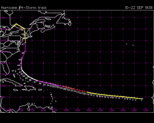
The track for the 1938 hurricane.
[image] [/image] [/image]
--------------------
Survived: 10 hurricanes in Rhode Island,Florida and the Yucatan of Mexico .
|
doug
Weather Analyst
Reged:
Posts: 1006
Loc: parrish,fl
|
|
Looking at that track, good ole bill will have to track well inside 70W to duplicate that scenario, or stay on 70 and be going north...He is at about 63 W now and the official track keeps it at 69.5 W or so...next 12 hours should tell us a lot.
--------------------
doug
|
MikeC
Admin
Reged:
Posts: 4811
Loc: Orlando, FL
|
|
Here's a link to the data here at this site with all 2 of those storms plus bill on there.
|
Ed in Va
Weather Master
Reged:
Posts: 489
Loc:
|
|
Good graphic. Bill is quite a bit to the east of the other two and we're light years past '38 and '54 in being able to forecast tracks. There is no practical reason to doubt the projection.
--------------------
Survived Carol and Edna '54 in Maine. Guess this kind of dates me!
|


 Threaded


 [/image]