Ed Dunham
Former Meteorologist & CFHC Forum Moderator (Ed Passed Away on May 14, 2017)
Reged:
Posts: 2565
Loc: Melbourne, FL
|
|
Just a reminder from the Site Rules:
"Low Content Posts: Please do not make single line posts containing no content (ie, "Thanks!" "Great Post" "Cool!", "I agree", or something else completely void of meaning). Or general cheerleading, for example, if you think someone did a good job and have nothing else to add send them a PM, it works better for this. We appreciate the thanks, but otherwise posts like these just litter up the forums."
Thanks for your help with this.
ED
|
syfr
Verified CFHC User

Reged:
Posts: 19
Loc: Central NC
|
|
Whoops, this is a live link, and the storm will disappear as it progresses.

Edited by syfr (Thu Sep 02 2010 08:24 PM)
|
Random Chaos
Weather Analyst

Reged:
Posts: 1024
Loc: Maryland
|
|
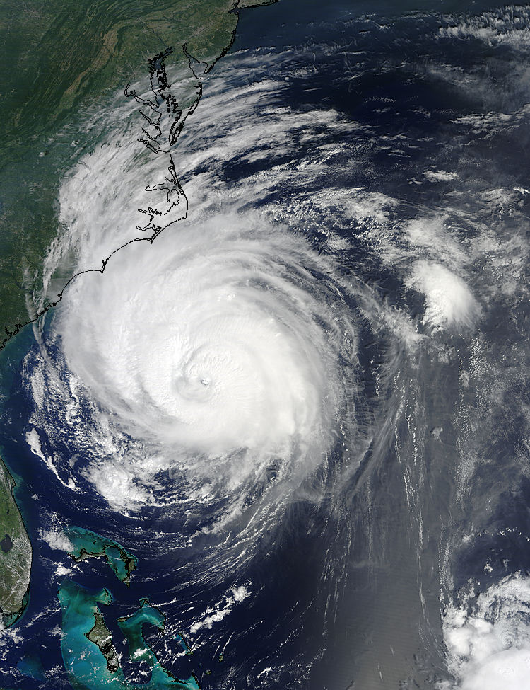
Today's beauty shot - 3:30 PM EST

Higher res versions: http://rapidfire.sci.gsfc.nasa.gov/gallery/?2010245-0902/Earl.A2010245.1529.2km.jpg
|
Storm Hunter
Veteran Storm Chaser

Reged:
Posts: 1370
Loc: Panama City Beach, Fl.
|
|
Pretty picture above. If you take a look at the flhurricane radar images being recorded from MHX... You can clearly see IMO the vertical shear that started affecting Earl today. Run the loop faster then normal and look at the SW side of the storm... check out how theres a low level banding on the SW that doesn't match up with the wider echos on the west side of coc. The lower bands are spinning faster in, but don't match up with the coc as the storms moves NNE. Granted i know the earth is round and the beam from radar is shooting out... Makes it harder to explain, so maybe it may be easier for you to just take a look? 
http://flhurricane.com/imageanimator.php?85
**just speed up loop after it loads... and watch the feeder bands on sw and west side***
Its pretty neat to see what appears to me to be a mid level jet (area of winds/dry air?) begin to disrupt the SW side of coc.
**see the a short video from Monday of Earl from the DC-8... note the flexing of wings in the eyewall at 38kft and the vortices in the eye... storm was north of Island Monday**
http://www.youtube.com/watch?v=dGnbfoN1vdg
**NASA's version*** http://www.youtube.com/watch?v=QyiI38FWU74
--------------------
www.Stormhunter7.com ***see my flight into Hurricane Ike ***
Wx Data: KFLPANAM23 / CW8771
2012== 23/10/9/5 sys/strms/hurr/majh
Edited by Storm Hunter (Fri Sep 03 2010 01:40 AM)
|
danielw
Moderator

Reged:
Posts: 3527
Loc: Hattiesburg,MS (31.3N 89.3W)
|
|
Test post
Test successful  --Tom --Tom
Edited by tpratch (Fri Sep 03 2010 09:23 AM)
|
MikeC
Admin
Reged:
Posts: 4811
Loc: Orlando, FL
|
|
To anyone from eastern North Carolina, how was Earl for your area? I'm glad another system has re curved before landfall.
|
danielw
Moderator

Reged:
Posts: 3527
Loc: Hattiesburg,MS (31.3N 89.3W)
|
|
The remnants of XTS Gaston are looking mighty impressive this morning. Latest visible satellite image below. Nearly all of the current models forecast a track along the Greater Antilles, similar, but to the south of Earl's track.

|
WesnWylie
Weather Guru
Reged:
Posts: 155
Loc:
|
|
The disturbance in the Bay of Campeche continues to organize late this afternoon. I think that this area is definitely something to watch, especially tomorrow, as it head northwest. I have a feeling that the will increase its chance to 40% this evening since it appears to be in a decent area for development.
Edited by WesnWylie (Sat Sep 04 2010 06:08 PM)
|
CarolinaGurl
Weather Watcher

Reged:
Posts: 36
Loc: Wilmington/Kure Beach, NC
|
|
Here in Wilmington Earl was a non event except for the rip currents. It was a little breezy but not bad at all and no rain, which we needed.
--------------------
My Storms - Hugo, Bertha, Bonnie, Fran, Dennis, Floyd, Ophelia, Ernesto, Irene. Arthur
|
OrlandoDan
Weather Master

Reged:
Posts: 458
Loc: Longwood, FL
|
|
Gaston has a nice burst of convection this morning. This one obviously warrants watching. I notice that the models refelct this moving on a fairy westward direction. I would not be surprised to see a more northerly component start to surface in the near future.
|
WesnWylie
Weather Guru
Reged:
Posts: 155
Loc:
|
|
90L is looking really good this morning. I think that the actual center is west of where the models show which would give it some more time to organize/strengthen. I have a feeling this will become a tropical depression by this afternoon.
--------------------
2011 Season Forecast: 16/09/04
2011 Systems: 10/01/01
|
syfr
Verified CFHC User

Reged:
Posts: 19
Loc: Central NC
|
|
I'm on Ocracoke Island, and tho Earl was quite close to here and many people evacuated, the island took very very little damage. More than anything, it dumped a lot of rain, a few shingles are off some roofs and a few docks were damaged.. Today, the ocean was almost millpond smooth.
|


 Threaded


 --Tom
--Tom
