Storm Hunter
Veteran Storm Chaser

Reged:
Posts: 1370
Loc: Panama City Beach, Fl.
|
|
RSO (Rapid Scan Operations) of Igor - 1 MIN updates! WOW... History with the NEW GOES-15 satellite, it was launched back in March this yr. 1 MIN UPDATES!!!! HI-RES.. beautiful storm!
http://rammb.cira.colostate.edu/ramsdis/...&height=600
--------------------
www.Stormhunter7.com ***see my flight into Hurricane Ike ***
Wx Data: KFLPANAM23 / CW8771
2012== 23/10/9/5 sys/strms/hurr/majh
|
Random Chaos
Weather Analyst

Reged:
Posts: 1024
Loc: Maryland
|
|
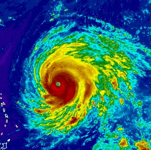
An absolutely beautiful storm:

And a close up of the eye:

Larger versions: http://rapidfire.sci.gsfc.nasa.gov/gallery/?2010256-0913/Igor.A2010256.1640.1km.jpg
|
Random Chaos
Weather Analyst

Reged:
Posts: 1024
Loc: Maryland
|
|
IR (ref) and WV (ref) is showing a marked weakening in the storm over the past couple hours, with ADT indicating a possible reduction in strength to around 120kts from the 130kts earlier. However, the last two IR frames are showing a significant increase in convenction surrounding the inner core. Additionally, the stadium eye is still extremely well defined and circular:

I suspect this has to do with interior dynamics changing in the storm. A secondary eyewall is forming, as seen in Microwave from several hours ago:

I suspect an cycle will be well underway within the next 6 to 12 hours, with no additional strengthening until after then. However, after an finishes, assuming conditions remain conducive to further strengthening, storms experience surface area growth as their structure becomes better suited for the size of the storm and the wind field expands as a direct result of the loss of the original eyewall. As the new eye contracts under favorable conditions, the winds will restrengthen, and often surpass the strength of the old storm.
Given that the storm is expected to be in favorable conditions for the next 48 hours, and the is beginning at diurnal maxima, we could see no significant weakening of the storm and possible strengthening of the storm due to this .
Edited by Random Chaos (Mon Sep 13 2010 10:42 PM)
|
WeatherNut
Weather Master
Reged:
Posts: 412
Loc: Atlanta, GA
|
|
In looking at the 250-850mb steering it looks like the high is building back. I'm not sure how well I am interpreting this though

--------------------
Born into Cleo (64)...been stuck on em ever since
Edited by WeatherNut (Mon Sep 13 2010 10:51 PM)
|
danielw
Moderator

Reged:
Posts: 3527
Loc: Hattiesburg,MS (31.3N 89.3W)
|
|
Apparently Igor is going to try to shoot the gap... or Col in this case. Last 7 hours of motion is near 300 degrees or WNW.
Shortwave/ trough dropping into the area north of Puerto Rico about 400 miles NW of Igor.
Will the trough pickup Igor or will he miss the bus?
|
JoshuaK
Weather Guru
Reged:
Posts: 159
Loc: Lakeland, FL
|
|
I was watching the last few frames of the Vis Loop. It looks like Igor did indeed make a turn to the NW, before moving to the WNW, but now it seems to be shifting back to a mostly W track, but this could be a mere wobble, have to wait for the next few frames to be certain.
|
Old Sailor
Storm Tracker

Reged:
Posts: 293
Loc: Florida
|
|
With big storms like Igor they tend to stair step so l they go NW then West back to NW , you need to watch a trend for 6 hours or more..
|
JoshuaK
Weather Guru
Reged:
Posts: 159
Loc: Lakeland, FL
|
|
Saw the update on the main page about Karl. I'm not too suprised really, since that triangle area between Cancun, Honduras, and the Cayman Islands in the Western Caribbean tends to produce a lot of strong storms (Wilma being the top evidence of that). If it survives transition over the Yucatan, are we looking at another impact in the same general region as Alex and Hermine? I imagine Texas probably still isn't dried out yet after that latter.
EDIT: 5PM isn't out yet, but it looks like Igor has intensified since earlier in the day. Without looking at data or Sat estimates, I'll predict an increase back up to 145 mph, at least, for 5PM. And to cover all the bases, looks like Julia is getting hit by strong shear from the WNW.
EDIT: Right on the money. =D
Everyone on Bermuda right now is probably hoping that the forecast track is waaaaayyyyy off for the latter period.
Edited by JoshuaK (Tue Sep 14 2010 05:03 PM)
|
danielw
Moderator

Reged:
Posts: 3527
Loc: Hattiesburg,MS (31.3N 89.3W)
|
|
I saw the nice banding start earlier after Karl's cruise across the Caribbean. Probably wont make it to Hurricane force winds before landfall. But I may have to eat crow on that.
Not a good night to be in Belize or Quintana Roo,MX
and probably Yucatan and Campeche,MX tomorrow.
Edited by danielw (Tue Sep 14 2010 05:27 PM)
|
Random Chaos
Weather Analyst

Reged:
Posts: 1024
Loc: Maryland
|
|
ADT values are increasing, with the upper end strength of the storm now showing potential for 140kt winds. However, this is unlikely given the eye structure. Microwave has shown the eye clearly open south for the past 6 hours or so, and the eye has taken on a ragged appearance. There is no sign of an taking place, either.
Recent motion (past 4 hours or so) has again trended west. Cloud tops have also cooled significantly over the past several hours.
Edit: Where are all our hurricane watchers? This is the 2nd big, beautiful storm in the last couple weeks and almost no one is showing up to talk about it!
Edited by Random Chaos (Tue Sep 14 2010 10:06 PM)
|
Beaumont, TX
Storm Tracker
Reged:
Posts: 318
|
|
Igor is a gorgeous storm, that is for sure. Winds near 155 mph. Just an impressive storm.
|
berrywr
Weather Analyst

Reged:
Posts: 387
Loc: Opelika, AL
|
|
These hurricanes are wonderful eye candy and unless you live in Bermuda none are a threat to the United States with the pattern we've been stuck in for the better part of summer...two distinct upper ridges, a persistent upper low over Eastern Canada, a stretching north to south to southwest to west and a COL....welcoming all passing hurricanes to a one way express ticket to the westerlies. The only game in town is recurvature if you're a Cape Verde system. I look at the long range models and over and over and over the same fate lies with all and if the shear doesn't take the trailing systems; the COL will snare them. The only systems were going to pay attention to are those that form in either the Caribbean or the Gulf of Mexico.
--------------------
Sincerely,
Bill Berry
"Survived Trigonometry and Calculus I"
|
Random Chaos
Weather Analyst

Reged:
Posts: 1024
Loc: Maryland
|
|
Over the past 6 hours, the eye has completely collapsed and is attempting to regenerate. Microwave shows what appears to be a gigantic 60nm eye trying to form around the old 15-20nm eye that is barely hanging on. This is the 9:40utc microwave pass.
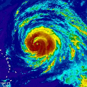
However, what I noticed that really grabbed my attention was the change in IR structure over the past 9 hours. Compare the two following pictures:
0215utc

1115utc

Note the complete shedding of outer convection and the wrapping of the outer bands over each other. This is classic preparation for an annular storm. From Wikipedia:
"Observations show that an eyewall replacement cycle can lead to the development of an annular hurricane. ... Annular hurricanes have been simulated that have gone through the life cycle of an eyewall replacement. The simulations show that the major rainbands will grow such that the arms will overlap, and then it spiral into itself to form a concentric eyewall. The inner eyewall dissipates, leaving a hurricane with a singular large eye with no rainbands."
That appears to be exactly what is happening with Igor. Igor is not yet annular, but it looks to be in the development process. The biggest hampering aspect is the southern rain band is not fully formed, meaning that the new outer eye is not 100%, allowing the old inner core to continue to be driven moisture from the south. Whether Igor completes the and becomes annular or is able to regenerate the old eye and stay non-annular is yet to be seen.
Edited by Random Chaos (Wed Sep 15 2010 08:26 AM)
|
Random Chaos
Weather Analyst

Reged:
Posts: 1024
Loc: Maryland
|
|
No posts all day?
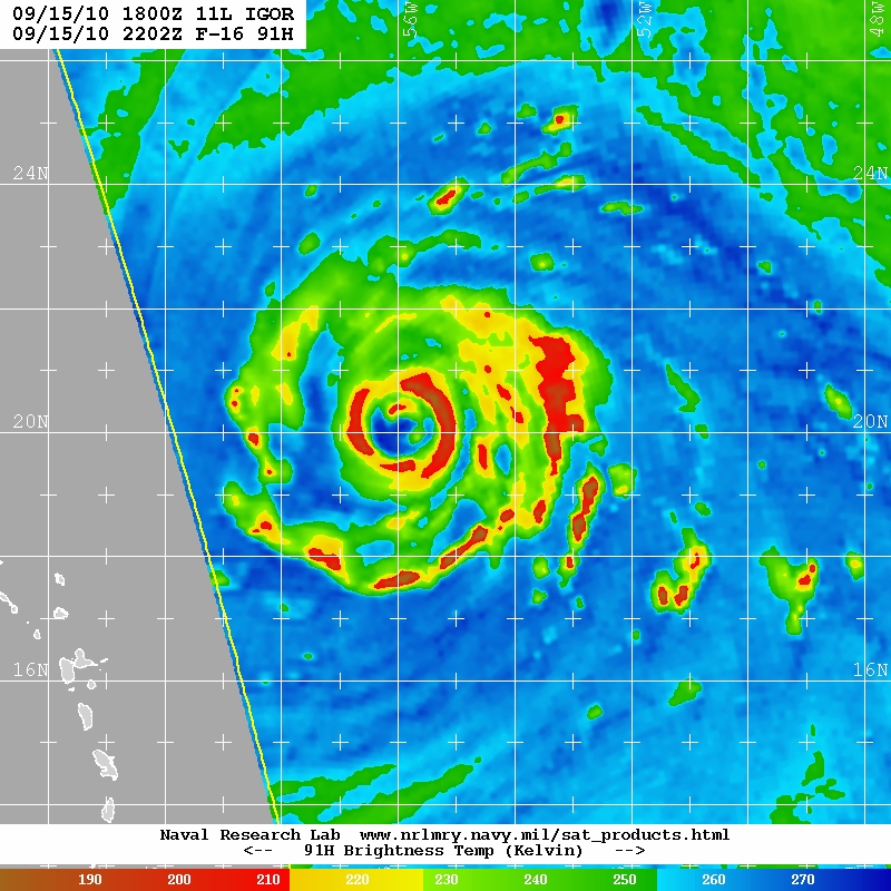
Evening update: SSMIS Microwave overpass about an hour ago shows a clear outer eyewall fully surrounding the nearly completely collapsed inner eyewall. The new eye wall appears to be 80-90nm in diameter - this diameter is based on a 1.5 degree latitude width. is still well underway. Organizationally, this storm is continuing to shed outer convection and wrap convective bands into a very large ring about the storm. There is very high axial symmetry to the storm that was not present this morning or yesterday. Will be interesting what the next 6 hours bring.
Reference: http://www.nrlmry.navy.mil/tcdat/tc10/AT...N-552W.47pc.jpg
Look at how much bigger Igor is vs this morning (previous post) - 2045utc:

Edited by Random Chaos (Wed Sep 15 2010 06:14 PM)
|
berrywr
Weather Analyst

Reged:
Posts: 387
Loc: Opelika, AL
|
|
What you're looking at is one, dry air entraining into the system and two, an eyewall replacement cycle; there are two eye walls here; the second about 60 nm out. It has contracted about 20 nm since this photo was taken. It is important to remember during eyewall replacement cycles the tops of these storms warm and while on IR there is a change in color does not mean it isn't there; I looked at a microwave loop today and the eye continues to exist though not on visible satellite; an obscure eye doesn't dismiss the fact it remains. has a chart with some skill in this area of expertise; however it remains to this day a crap shoot.
--------------------
Sincerely,
Bill Berry
"Survived Trigonometry and Calculus I"
|
Random Chaos
Weather Analyst

Reged:
Posts: 1024
Loc: Maryland
|
|
Except that the microwave penetrates the clouds and shows the inner core collapsed. Take a look at the internal structure as seen in the last microwave overpass (about 2 hours ago now, more recent than the one I last linked to). The outer eyewall appears fully established and the inner eyewall is restricted to a very small region in the north:

This is an absolutely enormous storm. From north to south the is the equivalent distance from Washington DC to Miami - around 750 to 800 miles! Or an area that covers the entire Gulf of Mexico! Or by another measurement, about 20-30% larger than Hurricane was.
Edited by Random Chaos (Wed Sep 15 2010 08:44 PM)
|
danielw
Moderator

Reged:
Posts: 3527
Loc: Hattiesburg,MS (31.3N 89.3W)
|
|
I see a 12Z ship report from the Bernardo Quintana A of 70 knot sustained wind just to the north of Cozumel,MX.
Further review indicates that it may have been an error or possibly rainband influenced.
A ship just over half the distance between Karl and the Bernardo reported 25 kt winds at the same observation.
15/18 C6KJ5 22.6 -87.0 28.0 100 14 1012.6 0.3 29.6 C6KJ5
15/12 C6KJ5 21.5 -86.6 020deg at 70knts 1010.4 1.8 30.5 * C6KJ5
13/18 C6KJ5 20.9 -86.7 31.0 060 7 1012.5 0.0 30.6 C6KJ5
13/06 C6KJ5 23.0 -87.8 29.0 040 16 1013.2 0.0 29.8 C6KJ5
http://www.sailwx.info/shiptrack/shipposition.phtml?call=C6KJ5
Edited by danielw (Wed Sep 15 2010 08:29 PM)
|
Random Chaos
Weather Analyst

Reged:
Posts: 1024
Loc: Maryland
|
|
FYI, looks like SSD is having problems again. The config files that tell the flash animations which slides to load are incorrect on one of their servers. If you know how to edit your hosts file, adding this line will fix the issue:
140.90.213.166 www.ssd.noaa.gov
Note that your browser might not pick this up immediately, and on some systems you will also have to flush your DNS cache. SSD uses several servers, and it seems that at least the server at 129.15.110.160 is not sending the right info, resulting in images from earlier today being displayed.
I recommend you remove the hosts entry after a day or two, as it will probably cause long term issues to leave it in.
|