MikeC
Admin
Reged:
Posts: 4835
Loc: Orlando, FL
|
|
7AM EDT Update 31 July 2017
During the past few hours deep convection has persisted and become a little better organized over the well-defined, formerly non-tropical low pressure center being tracked as Invest 98L, and the system is now a Tropical Depression, the sixth tropical cyclone of the 2017 Atlantic Hurricane Season.
Although not presently forecast to become stronger than a TD (given the shear and nearby dry air), smaller systems can have surprisingly large and unexpected changes in intensity, up or down, and a modest Tropical Storm into landfall is not out of the question. Locally heavy rains and gusty winds, regardless.
-Ciel
Tropical Storm Warnings up from Anclote River (just south of New Port Richie) to Bonita Beach Florida
2PM EDT Update 30 July 2017
The area in the northeast Gulf is now being tracked as Invest 98L, chances for development are up to 30% in the next 5 days and 20% in the next 48 hours. It continues to bring rain to Central and Northern Florida.
Original Update
A stalled out frontal system over the northeast gulf of Mexico has formed a surface low south-southwest of Panama City, FL and bringing rain to parts of Central and Northern Florida. Although the system isn't likely to develop into anything tropical in the near term, the rainfall and developing low will likely make for a nasty day or two in those areas. Because of the close proximity, We'll be watching the rather vigorous surface low to see if anything comes of it after Florida, right now there's a 10% chance this low develops within the next 48 hours and 20% over the next few days.

Parts of the area in Florida may have some rough weather associated with the front and low, but not much more than a typical afternoon storm (just longer duration)
Additionally the area in the central Atlantic has a 20% for development.
The gulf system has not been tagged as an invest yet.
Radar Recording for 98L approach
Edited by cieldumort (Mon Jul 31 2017 12:57 PM)
|
MikeC
Admin
Reged:
Posts: 4835
Loc: Orlando, FL
|
|
Radar recording up for 98L http://flhurricane.com/imageanimator.php?257
|
MikeC
Admin
Reged:
Posts: 4835
Loc: Orlando, FL
|
|
A few buoy reports of 40MPH winds west of Tampa, the low seems to be drifting southeast currently, probably would drift into the W. Central Florida coast. Watch this one closely, these frontal lows are prime for surprises.
|
MikeC
Admin
Reged:
Posts: 4835
Loc: Orlando, FL
|
|
Ft. Myers/Venice will likely be close to where the landfall point of Emily is.
https://tidesandcurrents.noaa.gov/waterlevels.html?id=8725520
Shows the water levels at Ft. Myers, currently running about a foot above normal. Rain will likely be the story with this system as it moves over central Florida. Thankfully the system doesn't have much more time over water or the surge could be a lot worse.
Tampa: https://tidesandcurrents.noaa.gov/waterlevels.html?id=8726607
|
cieldumort
Moderator

Reged:
Posts: 2712
Loc: Austin, Tx
|
|

In the image above, times are stamped in CDT.
Add an hour for Florida.
How to read:
This is a snapshot of both velocity (top) and precipitation (bottom). At the time of this scan there was a wide area within Emily's core of 70+ MPH winds only 1,200 to 2,000 feet above the surface, with max returns in the 80s to 90s. Given the heavy precipitation, a reduction ratio to 80% or so, at least in gusts, was likely occurring, as well as possible brief tornadoes. Once inland, this core of maximum winds dropped back down to modest tropical storm levels.
|
MikeC
Admin
Reged:
Posts: 4835
Loc: Orlando, FL
|
|
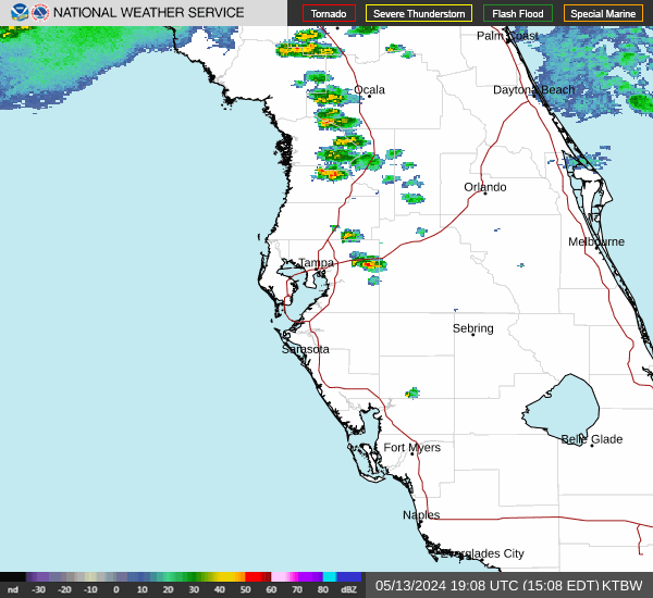
The center isn't well defined right now but its' just east of Tampa and south of Lakeland, most of the convection easies to spot on the Tampa radar, most of the convection ran off, although some rain over Orlando to the east and west is trying to wrap in toward it. Another center may form over the Atlantic, most of the frontal convection and rain is to the south and east.
The saved florida radar recording ( http://flhurricane.com/imageanimator.php?257 ) shows most of the rain south and east of the center, which is difficult to spot until near the end of the loop. The then convection races ahead toward Sebring, FL, leaving the center behind.
Emily will likely be downgraded very shortly.
|
cieldumort
Moderator
Reged:
Posts: 2712
Loc: Austin, Tx
|
|
Initial Local Storm Damage Reports from Tampa Bay NWS
0430 AM TROPICAL STORM 4 SE FORT MYERS BEACH 26.42N 81.90W
07/31/2017 LEE FL BROADCAST MEDIA
A SECTION OF ROOF WAS BLOWN OFF ONE BUILDING AND LANDED
ON ANOTHER AT THE OUTRIGGER BEACH RESORT IN FORT MYERS
BEACH. NO INJURIES WERE REPORTED.
1053 AM TROPICAL STORM 5 ESE FORT DESOTO PARK 27.60N 82.65W
07/31/2017 GMZ830 FL MESONET
WXFLOW SITE XSKY ON THE SKYWAY FISHING PIER REPORTED
TROPICAL STORM WIND GUST OF 57 MPH. AT THE TIME CARS WERE
SHOWN STOPPED ON THE BRIDGE AND UNABLE TO MOVE.
1054 AM TROPICAL STORM 5 S BRADENTON 27.42N 82.58W
07/31/2017 MANATEE FL PUBLIC
MOBILE HOME ROOF DESTROYED IN THE TRAILER ESTATE PARK AND
REC
Initial Local Storm Damage Report from Miami NWS
0112 PM TSTM WND DMG 2 NNW EAST NAPLES 26.17N 81.76W
07/31/2017 COLLIER FL LAW ENFORCEMENT
ROOF DAMAGE AT A CONSTRUCTION SITE ON PROGRESS AVE.
DEBRIS FROM THE ROOF ALSO DID DAMAGE TO A PICKUP TRUCK.
NAPLES AIRPORT REPORTED A WIND GUST OF 30MPH IN PREVIOUS
METAR. NO INJURIES REPORTED.
|
berrywr
Weather Analyst

Reged:
Posts: 387
Loc: Opelika, AL
|
|
What is spinning SE of Sebring, FL; that's SE of where Emily is suppose to be. I also have not noted an ENE movement on radar, satellite and surface observations support what radar and satellite are indicating. What I don't know is, is that Emily or an MCV or a 2nd LLC
--------------------
Sincerely,
Bill Berry
"Survived Trigonometry and Calculus I"
|
MikeC
Admin
Reged:
Posts: 4835
Loc: Orlando, FL
|
|
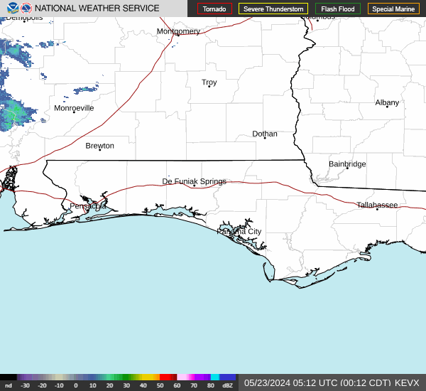
System currently in Gulf bringing a lot of rain to central/north florida.
|
MikeC
Admin
Reged:
Posts: 4835
Loc: Orlando, FL
|
|
42mph gust at the Cocoa weather station
https://www.wunderground.com/personal-weather-station/dashboard?ID=KFLCOCOA37#history
|
Lamar-Plant City
Storm Tracker

Reged:
Posts: 392
Loc: Plant City, Florida
|
|
Just as a late report on Emily in my area....7 inches of rain in my 'non-official' gauge in south Plant City on Monday night....water everywhere! Little to no wind damage but potential river flooding later in the week.
--------------------
If you don't like the weather, wait 5 minutes...
2023 Season Prediction: 17/6/2
|


 Threaded


