MikeC
Admin
Reged:
Posts: 4811
Loc: Orlando, FL
|
|
9:45 PM Update 31 August 2019
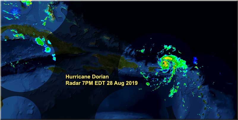
Recon is finding winds and pressures that could support Category 5 strength, as it is moving over very high heat content water tonight. This radar image, from Bahamas, shows the eye approaching Abaco island.
Florida will want to watch as well as the Southeast as it is expected to slow down greatly when it nears the Northwestern Bahamas.

6:00 AM Update 31 August 2019
Dorian remains a category 4 hurricane this morning, the intensity may fluctuate a bit over the day as the eye may fluctuate and go through replacement cycles, but in general is expected to remain a major hurricane today.
The biggest change is the chances for Florida impact are dropping as the official forecast has shifted quite a bit to the right, although most of Florida remains under the cone. If this trend continues it would bring much less of an impact on Florida, but it would increase the rest further up the coast into the Carolinas. Most of the common forecast models take it east of Florida and a few take it out to sea today. The Bahamas still are at risk from direct impacts. Florida is as well, but the odds are dropping. Indirect impacts will still be felt regardless, as a shift of only 50 miles or so west would make the impact much worse.
The speed and direction that Dorian follows today could push the models back to the west if the are further south or faster than forecast. Today will be critical for watching that to determine better some of the impacts.
Due to the trend in model track guidance, the National Hurricane Center has not issued a Hurricane Watch yet for any of FL but a Hurricane or Tropical Storm Watch is possible later today along portions of the Florida east coast.
Florida is not in the clear yet, the NOAA Gulfstream 4 jet that was supposed to take high altitude data sets yesterday had to return to Savannah for repairs, and never made it. The speed and direction of Dorian today and tomorrow will indicate how much of the morning models are handling it.
Listen to local media and officials for information for your particular area.
7:00 PM Update 30 August 2019
Still a great deal of uncertainty in the forecast. The cone has shifted to the right, but there are indications it could shift more (either direction) Those in the cone should continue to prepare.

9:30 PM Update 29 August 2019
Recon reports tonight are showing some strengthening in Dorian as it is shaking out the dry slot from it's southwest side. Likely enough to make it to category 2 later tonight. However it still has several days before approaching Florida.

The official forecast today has slowed down, dragging the landfall point later in the period to 96 hours, and increasing the risk that the area which is gets near will have prolonged tropical storm and/or hurricane conditions. In some cases maybe more than 24 hours of it. Those in the cone may want to prepare for prolonged exposure to that type of weather.
In the forecast lounge we discuss models, but I do want to bring them up because of the diverging ideas. If anyone says one particular run of a model is the start of a trend, it is not, if multiple models show the same thing and do so for more than one of the major runs (0z, 12Z) then it could be considered a trend. The mixed messages from the models today make me lean toward the 's official forecast more. Which states we'll have a major hurricane approaching Florida Monday, possibly a Category 4 Hurricane. Moving back the time frame is frustrating, since that also moves back the level of uncertainty. The models run from Recurve to South of the Florida Keys, some are fast, some are slow. And this is the date we hoped to know more. (Although think tomorrow night may be better for that)
The next major milestone in the forecast is the bend back to west. Does it happen later or sooner? The bend back to the west should be very noticeable just north of 25N, if it happens before then it gives more credence to the southerly models. If it's after the chance for it to find a hole in the ridge is greater. Again, it may be natural to gravitate to a model that is more favorable for you, but the official forecast is what you should be planning for. They have much better tools available to use than you can find publicly on the web. The cone was wrong for the approach tot he Greater Antilles, and it went to the east of that, but since then the forecast has been fairly good.
Keep monitoring, keep preparations going, and see below for a list of some local media and official sites, like floridadisaster.org. Anyone in the cone should be preparing with at least a plan. I do not know where this system will ultimate wind up, but I do know it will cause great impacts to wherever it does.
Also Tropical Storm Erin is no longer.
Original Update
Now Hurricane Dorian has strengthened today after missing the islands (correction it did go over St. Croix) and slipping in between Peurto Rico and St. Thomas. It now has a 20 mile wide eye, which was unexpected. It’s continuing to intensify and conditions just get better for it to intensify the further west it gets (At least for now). This results in Florida being under the gun for a major hurricane later this Labor Day Weekend.

In general Dorian should move generally to the northwest moving away from the islands and eventually turn back to the west or west northwest when the ridge is expected to build up. There is some weaker shear in the short term before it turns more west, but it may not be affected all that much. The Bahamas will be the first to deal with Dorian next, although the track does avoid most of the islands, and only the most northwestern islands will likely see any direct impact other than very rough surf. Those in cruise destinations in the Bahamas will likely get rerouted. Florida Cruise ports like Port Everglades and Port Canaveral may also get impacted on turnover days (Sunday/Monday) which could result in passengers disembarking at a different port than the one they started on.
Landfall time frame for Florida is likely Late Sunday night into Midday Monday, depending on specifically where it winds up. This is about 4 days away, you have through at least most of the Day on Saturday for preparations, but should be wrapped up before Sunday. If it slows down some you may have early Sunday morning as well, but by then it’s very possible windy conditions will start to impact the area where it ultimately winds up making things more difficult.
A State of Emergency was issued by Ron DeSantis for Florida today to activate many of the state and local government agencies and to open up communications. Starting around lunchtime today many places started to be slammed by folks getting early supplies. There may be resupplies by Friday in a lot of places, so if you run into outages now, check back on Friday. Official Watches for Florida may go up as early as tomorrow night (Thursday), but more likely on Friday.
It’s a bit early for shutters, but it may be a good idea to check your evacuation zone if you are anywhere near the coast. Evacuation orders are primarily for the purpose of avoiding storm surge, the rising water from the ocean or wind pushed walls of water that could rise quickly and flood buildings. Especially near the ocean or inland waterways like the Intracoastal. If you are asked to evacuate do so. If you are not, it is your call, but consider all the traffic exiting (which may take excessively long, even on back roads – Make sure you have alternate routes and use traffic aware routing monitoring apps like Google or Waze)
Find local TV, Radio stations (News stations like 96.5 here in Orlando are usually better equipped for reporting, but most radio stations will switch to a simulcast of a local TV station when things get dangerous). Battery powered radios are preferable if power goes out, you can use phone apps, assuming the cell network stays out (Cat 4+ is when those start to fail like in Hurricane Michael).
Freeze as much water as you can, do any laundry BEFORE the storm arrives, make sure you're stocked up on water, gator-aide , Stay hydrated, and get sleep while you can. It will be difficult to impossible to sleep while the storm is passing. During Irma I could not sleep, I had all the exterior lights (including floodlights) on at the house, and peeked out whenever I heard something. Fill up any large water coolers. Use bathtub, pool water, or other large basin for things like flushing the toilet if you lose water pressure. Be careful with any generators do NOT place them inside or in garages, keep them outdoors. Be careful with gas grills and propane.
Be wary of anyone claiming they know exactly what will happen. Beware of hype, and click bait. Yes some of the models will show crazy things, and some of them may actually be possible, but do not dwell on them.
Please pay attention to local media and officials for the latest information. Although we will update from time to time, we can’t cover everything, and many of us are located in Florida ourselves, so we may be preoccupied.
This will likely be an unforgettable Labor day weekend in Florida. All of us at flhurricane.com wish you and your family the best, and hope for your safety. Still holding out hope for a last minute swing out to sea, but it seems extremely unlikely at this point.
Follow along with us in the 2019 Forecast Lounge , as well as here on the Homepage.
Links to individual Forecast Lounges:
Tropical Storm Erin Lounge, Hurricane Dorian Lounge, W Gulf Low _90L_ Lounge
Have any questions or suggestions for preparing for Dorian? Please join the conversation: Dorian Prep ASK/TELL
http://www.FloridaDisaster.org - Florida Emergency Management Page
Bahamas Radar
News Media (East Central Florida):
Television:
Newspapers:
News Radio:
Check local media and officials when a storm is approaching your area.
News Media (South Florida):
Television:
Newspapers:
News Radio:
Check local media and officials when a storm is approaching your area.
Caribbean Radar Recording
Invest 98L Lounge W Gulf Trof Lounge
|
MikeC
Admin
Reged:
Posts: 4811
Loc: Orlando, FL
|
|
Recon recently found 988mb of pressure, so it's gradually building. It may hit some light shear from the upper level low to its west tomorrow, but probably not enough to weaken it. It's Best development conditions may be right before landfall, unfortunately.
We also update the Twitter feed with commentary and interesting retweets, and the facebook page. (Both linked at left)
|
Jim Anderson
Registered User
Reged:
Posts: 1
Loc: VA
|
|
I take exception to your headline comment about Dorian missing the islands. It came over St. Croix before skirting between Puerto Rico and St. Thomas.
|
typhoon_tip
Meteorologist
Reged:
Posts: 576
|
|
Track guidance is divergent toward the ended of the short range, when unfortunately Dorian's approach to the eastern coast of Florida will be occurring...
In the larger synoptic scope, questions have arisen ( considering the trends of Global numerical model clusters ) as to how changes in the westerlies over North America will impose and influence Dorian's track. Details of Dorian's destiny will be determined by timing those subtle and/or not so subtle influences.
At least through 48 hours ... not much will change, however. In that window, Dorian is reasonably clustered along a west-northwest motion that should take it through the northern Bahama archipelago. Beyond that, divergence increases considerably. Some suggestion of slowing the system and even turning it north along the coast, having failed to actually bring it inland are in the mix of plausible solutions. While there are just as viable solutions that are in conflict bringing Dorian onshore. Either way, the consensus is perilously close to the eastern coast of Florida, between Miami and Cape Canaveral about 72 hours from now, after which does continue inland between those ~ reference points ( caveat subject to change applies...).
Intensity, as usual, comes with its own headaches. Possibilities still exist for more and less, but more appears likely at this time. This may not be the best news for particularly vulnerable sea/tide exposed civility infrastructures along the SE coast of the state. In either case, Floridians and in fact, even up the coast toward GA/Carolinas ... all need to be paying very close attention to the status of Dorian. I can tell you it is a bit disconcerting that some of these guidance are having trouble capping the upper bound of intensity. There are always a handful of guidance that'll do that, but Dorian will be in a lowered(ing) shear with superb oceanic heat content during the next two days.
|
OrlandoDan
Weather Master

Reged:
Posts: 458
Loc: Longwood, FL
|
|
I would expect the 1700 update to move the track North and East, but not nearly as much as the Euro. We need to see a couple of runs more of the and at least one more of the Euro to start moving the track in a radical way.
|
MichaelA
Weather Analyst

Reged:
Posts: 956
Loc: Pinellas Park, FL
|
|
Folks on the east coast of Florida should seriously plan to evacuate no later than Sunday. Personally, I’d be leaving tomorrow.
--------------------
Michael
PWS
|
typhoon_tip
Meteorologist
Reged:
Posts: 576
|
|
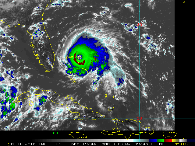
Absolutely stunning high resolution visible satellite as the sun lowers elevation stage left casts oblique rays across the structure of Dorian.
Edited by typhoon_tip (Fri Aug 30 2019 06:22 PM)
|
MikeC
Admin
Reged:
Posts: 4811
Loc: Orlando, FL
|
|
Recon recently found 946mb of pressure, pretty big drop from the 5pm advisory, Dorian is probably a Cat 4 now.
|
MikeC
Admin
Reged:
Posts: 4811
Loc: Orlando, FL
|
|
Recon continues to be crazy:
129knot at flight level 119 smfr. (aka about 140mph winds at the surface)
|
Psyber
Storm Tracker

Reged:
Posts: 242
Loc: Ontario, Canada
|
|
CNN said pressure dropped 20mb between sets of dropsones resulting in the rapid rapid intensification.
--------------------
The safest way to deal with a potential Hurricane hitting you...is to leave and just not be there at all.
|
Robert Lauriault
Registered User
Reged:
Posts: 2
|
|
Mike, in your effort to remain conservative and avoid hype, I wonder if you are not going to far.
A Cat 4 storm 40 or 50 miles off the coast would produce a storm surge that would do enormous damage. St. Augustine has been flooded in the last two storms and may be again. Real estate values there will likely tank if that happens as it will become virtually impossible to insure properties that have been flooded three times. Other coastal locations may suffer the same. We have all seen a number of storms threaten the east coast and then, at the last minute, veer off shore. I prey that that is what will happen this time as well, but a nearby Cat 3 could be worse than an on-shore Cat 1. Do you see my point?
|
cieldumort
Moderator

Reged:
Posts: 2664
Loc: Austin, Tx
|
|
AF308 Mission #25 into Dorian just found a mean 135 KTS in the lowest 150 meters when penetrating the NE eyewall.
NOAA2 Mission #26 just found a mean 143 KTS in the lowest 150 meters in the NE eyewall.
Taken together, these could support an upgrade to Cat 5 very soon.
|
Prospero
Storm Tracker

Reged:
Posts: 269
Loc: Gulfport, FL
|
|
Amazon delivery for today:
Now expected September 1 - September 3
We're sorry your package is running late
We're working to get your package back on track, and we'll let you know when your package is out for delivery.
Oh come on, we don't even have any conditions yet! Except empty gas stations...
--------------------
Gulfport Florida Webcam - Gulfport Florida Weather Station - Clearwater Beach Cams
|
MikeC
Admin
Reged:
Posts: 4811
Loc: Orlando, FL
|
|
Recon found 936.6mb... 26.2N 74.8W w/ 141 knots. It's pushing into Cat 5 now, it's entering into a very high heat content area in the water right now.
|


 Threaded


