F
Current Radar or Satellite Image

Flhurricane.com - Central Florida Hurricane Center - Tracking Storms since 1995Hurricanes Without the Hype! Since 1995


The 2024 Atlantic Hurricane Season Begins on June 1st and lasts until Nov 30th. NHC Outlooks resume on May 15th..
Days since last H. Landfall - US: Any 237 (Idalia) , Major: 237 (Idalia) Florida - Any: 237 (Idalia) Major: 237 (Idalia)


Archives 2020s >> 2021 News Talkbacks

Pages: 1
MikeCAdministrator
Admin


Reged:
Posts: 4544
Loc: Orlando, FL
June Gulf System Claudette
      #113779 - Sat Jun 12 2021 02:27 PM

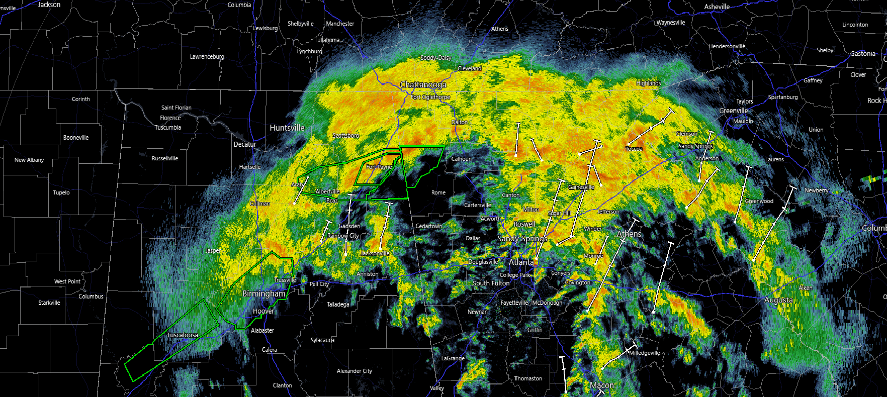
Midnight EDT 20 June Update
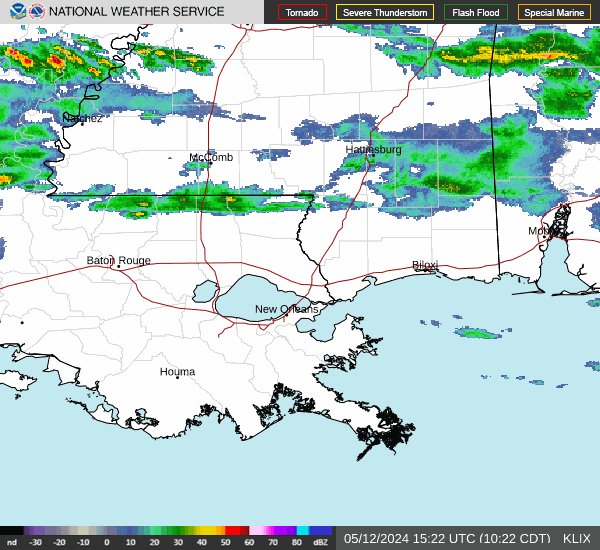
Claudette is moving throw Alabama tonight dropping Incredible amounts of flooding rain in the Tuscaloosa and Birmingham, Fort Payne areas in Alabama and Dalton in Georgia, it will likely move over Georgia and South Carolina before exiting into the Atlantic. Because of the alignment, its gotten slightly more organized (not necessarily stronger) at least for rain impacts, as it continues to pour. Those who may see Flooding Rain include extreme southeastern Tennessee, Northern Georgia, and along the NC/SC line through to the outer banks. The amount of rain in some of the bands could create flash flooding in some areas. Those in the areas with the heavy bands, please do not underestimate Claudette.

Earlier some of the strongest winds gusts were felt along coastal Mississippi, Alabama, and the Western Florida Panhandle, including an 81mph gust recorded at the Pensacola airport. The system was winding up quickly at landfall, and is why it seemed to get a name over land.


8AM EDT 18 June Update
Tropical Storm Claudette has formed just offshore of Louisiana this morning and the majority of rain and weather in impacting points east, particularly in Alabama and the Western Florida Panhandle where a few tornadoes have been seen, as well as bands of very heavy rain to the east of the Center.


8AM EDT 17 June Update
92L in the Gulf is up to 90% chance for development, advisories may begin later today, although it still remains very broad and spread out and not terribly organized at the moment. Again, most of the rain is well east of the center on the NHCs map, and streaming over Florida again today, if it does develop, the convection and rain will still be mostly, if not almost all on the east side and stretch into the Panhandle. Strong wind likely won't be much of a problem with this one.

Beyond that it, along with a front will make for a rainy week in most of the Southeastern US.

8AM EDT 16 June Update
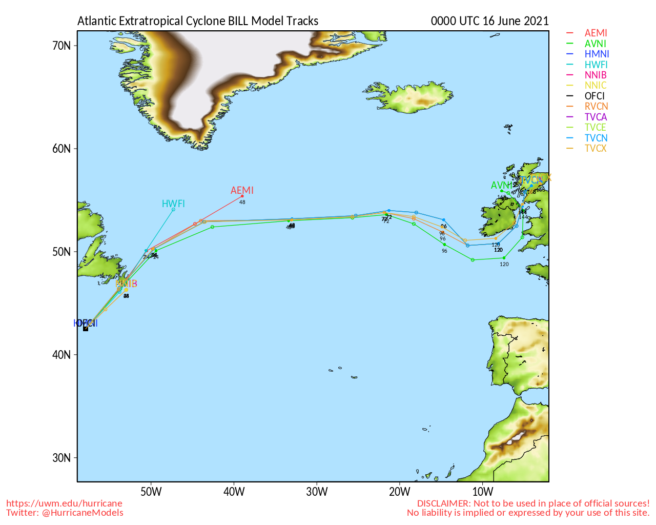
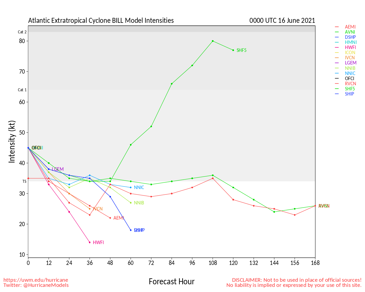
Tropical Storm Bill no longer exists and the system in the east Atlantic 94L missed its chance to develop, however 92L In the Gulf if now up to a 90% chance to develop as it tries to slowly get its act together in the Southwestern Gulf.

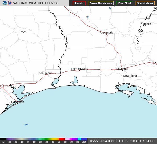
92L is very broad with energy in the southern Bay of Campeche all the way to the North tip of the Yucatan, the shearing is pushing much of the rain to the east, so if it does develop or not depends on how much one are consolidates or not. If it does develop it will likely stay weak and the rain will still be very easy heavy, assuming the center went into Louisiana, the heaviest rain/squalls may still be well east of that, into Alabama and the Western Florida Panhandle. Even before this the shearing will greatly enhance the rain over much of Florida again today and the general area of this storm likely won't move much today or tomorrow until the evening.

8AM EDT 15 June Update
Tropical Storm Bill is moving away from land quite rapidly in the North Atlantic, and the area in the southwestern Gulf is now at a 70% chance for development over the next 5 days or so.

The Gulf system (92L) is likely to remain weak, with most of the rain well to the east of the center, it may bring some minor surge along the northern Gulf coast and a lot of rain, but it's worth watching for those in the area. Some of the first bands should reach parts of Louisiana on Friday morning but the center likely won't arrive until Saturday morning, those around the center point of landfall may not notice much since the majority of the convection is sheared to the east. The majority of the weather associated with this system will likely be east, with a lot of moisture streaming into those areas. The west side of the system likely won't see much at all. There may be short lived weaker tornadoes associated with this system, especially east of the system, all the way into the Western Florida Panhandle.

The other area in the Eastern Atlantic (94L) has a 10% chance to develop, and probably will remain low chance. (It's June)

10AM EDT 14 June Update
The National Hurricane Center will initiate advisories on Tropical Depression Two, located offshore of the coast of North Carolina and moving away from the United States, at 1100 AM EDT

8AM EDT June 14 2021 Update
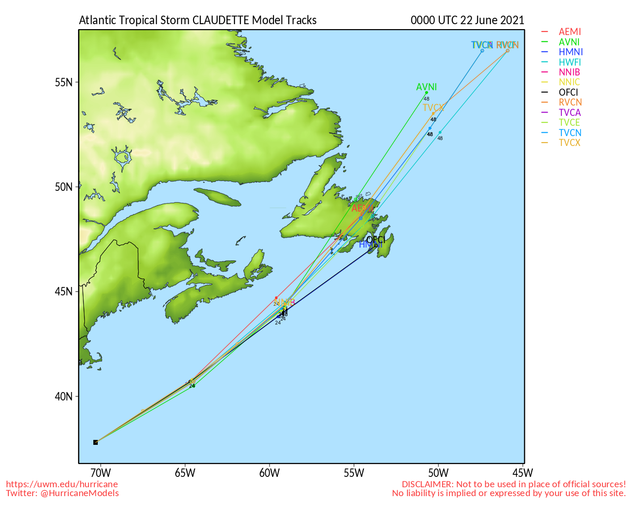
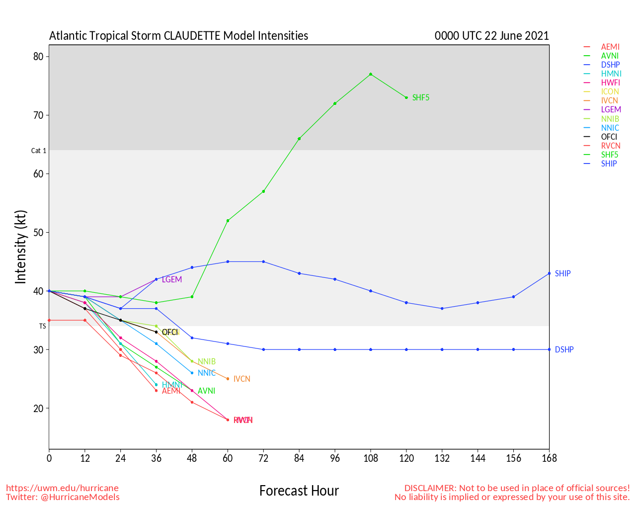
3 Areas in June is unusual, however, there is Invest 93L off the Carolina coast that ramped up quickly overnight and now has a 70% chance to develop as it it moves away from land. It seems likely to develop into a short lived subtropical or tropical System, and could become Bill later today.

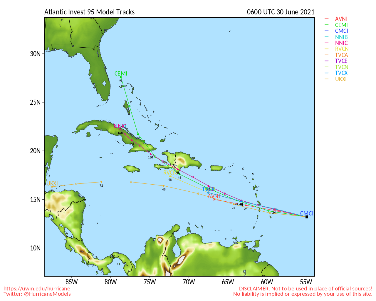
92L, the area in the Bay of Campeche, has a 60% chance to develop over the next 5 days, and has the potential to organize and cause a large rain event in the north Gulf coast, particularly east of where the center would eventually cross.

The area in the far east Atlantic, is much less likely to develop, but the potential is still there, at 20% over the next 5 days.

Original Update

The area in the Bay of Campeche along the southwestern Gulf of Mexico now has a 40% chance to develop over the next 5 days, and a 10% chance within the next 48 hours. It's likely going to be mostly a rain event. With the overall pattern and the winds at higher levels in the atmosphere, if anything develops, it likely would be a sheared system with most of rain and convection to right of the center. Still worth watching for those along the northern Gulf coast for late this coming week into next weekend.

For those in Mexico, it will bring a lot of rain as it tries to consolidate.

Currently there is no invest area for this system. The forecast lounge is discussing the longer range models on it.


North Gulf Links <html><a href="http://radar.weather.gov/Conus/southmissvly_loop.php" onMouseover="ddrivetip('<img src=\'http://radar.weather.gov/Conus/Loop/southmissvly_loop.gif\'>');" onMouseout="hideddrivetip();">North Gulf/Southern Mississippi Valley Composite Radar Loop</A>

(<a href="http://radar.weather.gov/Conus/southmissvly.php" 

onMouseover="ddrivetip('<img src=\'http://radar.weather.gov/Conus/RadarImg/southmissvly.gif'\>');" onMouseout="hideddrivetip();">Latest Static</a></html>) East to West:

<html> <a href="https://radar.weather.gov/ridge/lite/K</html>MOB<html>_loop.gif" onMouseover="ddrivetip('<img src=\'https://radar.weather.gov/ridge/lite/K</html>MOB<html>_loop.gif\'>');" onMouseout="hideddrivetip();"></html>Mobile, AL Radar<html> Radar Loop</A>

(<a href="https://radar.weather.gov/ridge/lite/K</html>MOB<html>_0.gif" onMouseover="ddrivetip('<img src=\'https://radar.weather.gov/ridge/lite/K</html>MOB<html>_0.gif\'>');" onMouseout="hideddrivetip();">Latest Static</a>)</html>

<html> <a href="https://radar.weather.gov/ridge/lite/K</html>LIX<html>_loop.gif" onMouseover="ddrivetip('<img src=\'https://radar.weather.gov/ridge/lite/K</html>LIX<html>_loop.gif\'>');" onMouseout="hideddrivetip();"></html>New Orleans, LA Radar<html> Radar Loop</A>

(<a href="https://radar.weather.gov/ridge/lite/K</html>LIX<html>_0.gif" onMouseover="ddrivetip('<img src=\'https://radar.weather.gov/ridge/lite/K</html>LIX<html>_0.gif\'>');" onMouseout="hideddrivetip();">Latest Static</a>)</html>

<html> <a href="https://radar.weather.gov/ridge/lite/K</html>LCH<html>_loop.gif" onMouseover="ddrivetip('<img src=\'https://radar.weather.gov/ridge/lite/K</html>LCH<html>_loop.gif\'>');" onMouseout="hideddrivetip();"></html>Lake Charles, LA Radar<html> Radar Loop</A>

(<a href="https://radar.weather.gov/ridge/lite/K</html>LCH<html>_0.gif" onMouseover="ddrivetip('<img src=\'https://radar.weather.gov/ridge/lite/K</html>LCH<html>_0.gif\'>');" onMouseout="hideddrivetip();">Latest Static</a>)</html>

<html> <a href="https://radar.weather.gov/ridge/lite/K</html>HGX<html>_loop.gif" onMouseover="ddrivetip('<img src=\'https://radar.weather.gov/ridge/lite/K</html>HGX<html>_loop.gif\'>');" onMouseout="hideddrivetip();"></html>Houston/Galveston, TX Radar<html> Radar Loop</A>

(<a href="https://radar.weather.gov/ridge/lite/K</html>HGX<html>_0.gif" onMouseover="ddrivetip('<img src=\'https://radar.weather.gov/ridge/lite/K</html>HGX<html>_0.gif\'>');" onMouseout="hideddrivetip();">Latest Static</a>)</html>

Gulf of Mexico Satellite Imagery

Area Forecast Discussions: Mississippi/Alabama/Pensacola - New Orleans, LA - Lake Charles, LA - Houston/Galveston, TX


Mid-Atlantic/Carolina Links <html><a href="http://radar.weather.gov/ridge/Conus/southeast_lite_loop.php" onMouseover="ddrivetip('<img src=\'http://radar.weather.gov/ridge/Conus/Loop/southeast_loop.gif\'>');" onMouseout="hideddrivetip();">Southeast Composite Radar Loop</A>

(<a href="http://radar.weather.gov/ridge/Conus/southeast_lite.php" 

onMouseover="ddrivetip('<img src=\'http://radar.weather.gov/ridge/Conus/RadarImg/southeast.gif\>');" onMouseout="hideddrivetip();">Latest Static</a></html>)

<html> <a href="https://radar.weather.gov/ridge/lite/K</html>clx<html>_loop.gif" onMouseover="ddrivetip('<img src=\'https://radar.weather.gov/ridge/lite/K</html>clx<html>_loop.gif\'>');" onMouseout="hideddrivetip();"></html>Charleston, SC Radar<html> Radar Loop</A>

(<a href="https://radar.weather.gov/ridge/lite/K</html>clx<html>_0.gif" onMouseover="ddrivetip('<img src=\'https://radar.weather.gov/ridge/lite/K</html>clx<html>_0.gif\'>');" onMouseout="hideddrivetip();">Latest Static</a>)</html>

<html> <a href="https://radar.weather.gov/ridge/lite/K</html>ltx<html>_loop.gif" onMouseover="ddrivetip('<img src=\'https://radar.weather.gov/ridge/lite/K</html>ltx<html>_loop.gif\'>');" onMouseout="hideddrivetip();"></html>Wilmington, NC Radar<html> Radar Loop</A>

(<a href="https://radar.weather.gov/ridge/lite/K</html>ltx<html>_0.gif" onMouseover="ddrivetip('<img src=\'https://radar.weather.gov/ridge/lite/K</html>ltx<html>_0.gif\'>');" onMouseout="hideddrivetip();">Latest Static</a>)</html>

<html> <a href="https://radar.weather.gov/ridge/lite/K</html>mhx<html>_loop.gif" onMouseover="ddrivetip('<img src=\'https://radar.weather.gov/ridge/lite/K</html>mhx<html>_loop.gif\'>');" onMouseout="hideddrivetip();"></html>Morehead City, NC Radar<html> Radar Loop</A>

(<a href="https://radar.weather.gov/ridge/lite/K</html>mhx<html>_0.gif" onMouseover="ddrivetip('<img src=\'https://radar.weather.gov/ridge/lite/K</html>mhx<html>_0.gif\'>');" onMouseout="hideddrivetip();">Latest Static</a>)</html>

<html> <a href="https://radar.weather.gov/ridge/lite/K</html>akq<html>_loop.gif" onMouseover="ddrivetip('<img src=\'https://radar.weather.gov/ridge/lite/K</html>akq<html>_loop.gif\'>');" onMouseout="hideddrivetip();"></html>Norfolk/Wakefield, VA Radar<html> Radar Loop</A>

(<a href="https://radar.weather.gov/ridge/lite/K</html>akq<html>_0.gif" onMouseover="ddrivetip('<img src=\'https://radar.weather.gov/ridge/lite/K</html>akq<html>_0.gif\'>');" onMouseout="hideddrivetip();">Latest Static</a>)</html> 

Area Forecast Discussions: Charleston, SC - Wilmington, NC - Morehead City, NC - Norfolk/Virginia Beach/Hampton Roads, VA

Power Outage Maps: South Carolina Power Outage Map North Carolina Power Outage Map Virginia Power Outage Map


Post Extras: Print Post   Remind Me!   Notify Moderator  
Pages: 1


Extra information
0 registered and 0 anonymous users are browsing this forum.

Moderator:  

Print Topic

Forum Permissions
      You cannot start new topics
      You cannot reply to topics
      HTML is disabled
      UBBCode is enabled

Rating:
Topic views: 4274

Rate this topic

Jump to

Note: This is NOT an official page. It is run by weather hobbyists and should not be used as a replacement for official sources. 
CFHC's main servers are currently located at
Hostdime.com in Orlando, FL.
Image Server Network thanks to Mike Potts and Amazon Web Services. If you have static file hosting space that allows dns aliasing contact us to help out! Some Maps Provided by:
Great thanks to all who donated and everyone who uses the site as well. Site designed for 800x600+ resolution
When in doubt, take the word of the National Hurricane Center