cieldumort
Moderator

Reged:
Posts: 2517
Loc: Austin, Tx
|
|
11PM EDT 5 July Update
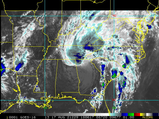
Elsa is back over water in the Gulf of Mexico, forecast keeps it as a Tropical storm until Landfall Wednesday morning near the west coast, close to Horseshoe beach. Parts of the coast Tampa Bay, north to the Big Bend may see 3-5 feet of storm surge in certain areas.
From the official discussion:
Some of the intensity models, such as SHIPS and some of the global models showing Elsa possibly reaching 60 kt just before landfall along the northwestern Florida peninsula. This would typically require a Hurricane Watch for a small portion of northwest Florida. However, given that Elsa has been hugging a very tight mid-level moisture gradient -- a condition that is expected to continue until landfall occurs in about 36 hours -- the new official intensity forecast remains similar to the previous advisory and holds the peak intensity at 55 kt due to expected intermittent dry-air intrusions. Subsequent forecasts can assess the new reconnaissance and model data that will be coming in later tonight, and determine if an increase in the intensity forecast and the issuance of a hurricane watch or warning is required. I.e. you may wake up to a hurricane warning along parts of the west coast of Florida.
6PM EDT 3 July Update
New Tropical Storm Watches and Warnings are up tonight, including the Florida Keys, as Tropical Storm Elsa narrowly misses crossing southern Haiti and looks to be spending more time over very warm water en route to Cuba.
Depending in large part on what parts of and how brief (or long) the cyclone spends over Cuba, Elsa may be stronger (or weaker) than currently anticipated when entering the Gulf of Mexico.
At present, the low-level circulation, which has been partially to mostly exposed for nearly a day now, is tucking itself back under some convection as showers and thunderstorms are building upshear, likely getting an orographic assist with from cyclone interacting with Hispaniola.
The forecast scenario remains too complex for any one model or even suite of models, but seems to have a pretty good handle on Elsa, and tropical storm/hurricane preparations are in order wherever they have watches and warnings in effect.
3PM EDT 2 July Update
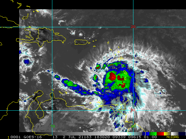
Elsa has continued to organize and strengthen despite a rapid forward speed and higher net effective shear, given that rapid forward motion, and as of the 2PM AST update, is now an 85MPH Cat 1 on the Saffir-Simpson scale.
With continued forward motion at nearly 30 MPH and some nearby dry air, it is unclear how long this on-and-off intensification can go on for, but suffice it to say, Hurricane Elsa's intensity is now well-above the earlier forecasts, even ahead of schedule of the more bullish model runs, and so it could be best not to count on a sustained leveling off or weakening trend any time soon, and interests in the central to western Caribbean may want to begin wrapping up hurricane preparations for the likelihood of impact.
How strong Elsa is next week after land interaction in the Caribbean is also unclear, but Florida for certain should be keeping a watchful eye. Steering patterns favor at least some Florida impact, and that is the official forecast from .
Full Caribbean radar loop recording is now live:
Elsa 2021 Full Caribbean Radar Loop Recording
Initial Update
Atlantic Hurricane Season 2021 has just told 2020 to hold its beer.
Advisories have begun on the potential fifth named storm of the swift start to the 2021 Atlantic Hurricane Season with Invest 97L. This incipient tropical cyclone being born unseasonably early in the Main Development Region (MDR) of the Tropical Atlantic is far more like what we would expect to see in the heart of a season, not the very first official month.
Model guidance on FIVE is warm to very warm, and getting warmer. Interests in the eastern Caribbean and points west to northwest may want to begin paying very close attention to official guidance.
We also now have a Forecast Lounge up just for FIVE to discuss its model runs in greater detail and speculate more freely
Elsa (FIVE) Forecast Lounge
Elsewhere, we are still keeping a watchful eye on Invest 95L, which is still somewhat coherent, but struggling in the higher shear/subsident zone of the eastern Caribbean. Also of some interest is the persistent weather maker along the far western Gulf of Mexico, now analyzed with a surface "Low" in the Bay of Campeche.
5:00PM AST June 30, 2021 WATCHES AND WARNINGS
--------------------
The Meteorological Service of Barbados has issued a Tropical Storm Watch for Barbados, St. Vincent, and the Grenadines.
The Meteorological Service of St. Lucia has issued a Tropical Storm Watch for St. Lucia.
The Government of France has issued a Tropical Storm Watch for Martinique.
SUMMARY OF WATCHES AND WARNINGS IN EFFECT:
A Tropical Storm Watch is in effect for...
* St. Vincent and the Grenadines
* St. Lucia
* Barbados
* Martinique
A Tropical Storm Watch means that tropical storm conditions are possible within the watch area, generally within 48 hours.
Edited by MikeC (Tue Jul 06 2021 12:47 PM)
|
cieldumort
Moderator

Reged:
Posts: 2517
Loc: Austin, Tx
|
|
200 PM AST Fri Jul 02 2021Quote:
SUMMARY OF 200 PM AST...1800 UTC...INFORMATION
----------------------------------------------
LOCATION...13.7N 62.5W
ABOUT 95 MI...155 KM WNW OF ST. VINCENT
ABOUT 580 MI...935 KM ESE OF SANTO DOMINGO DOMINICAN REPUBLIC
MAXIMUM SUSTAINED WINDS...85 MPH...140 KM/H
PRESENT MOVEMENT...WNW OR 290 DEGREES AT 29 MPH...46 KM/H
MINIMUM CENTRAL PRESSURE...991 MB...29.26 INCHES
WATCHES AND WARNINGS
--------------------
CHANGES WITH THIS ADVISORY:
The Meteorological Service of the Cayman Islands has issued a Tropical Storm Watch for the islands of Cayman Brac and Little Cayman.
The Meteorological Service of Barbados has changed the Hurricane Warning for St. Vincent and the Grenadines to a Tropical Storm Warning, and has discontinued the Tropical Storm Warning for Barbados.
The Meteorological Service of St. Lucia has changed the Hurricane Warning for St. Lucia to a Tropical Storm Warning.
SUMMARY OF WATCHES AND WARNINGS IN EFFECT:
A Hurricane Warning is in effect for...
* Southern coast of Dominican Republic from Punta Palenque to theborder with Haiti
* Southern portion of Haiti from Port Au Prince to the southernborder with the Dominican Republic
A Tropical Storm Warning is in effect for...
* St. Vincent and the Grenadines
* St. Lucia
* Martinique
* Dominica
* The coast of Haiti north of Port Au Prince
* South coast of the Dominican Republic east of Punta Palenque to Cabo Engano
* Jamaica
A Hurricane Watch is in effect for...
* Jamaica
A Tropical Storm Watch is in effect for...
* Grenada and its dependencies
* Saba and Sint Eustatius
* North coast of the Dominican Republic from Cabo Engano to Bahia de Manzanillo
* Cayman Brac and Little Cayman
|
danielw
Moderator

Reged:
Posts: 3527
Loc: Hattiesburg,MS (31.3N 89.3W)
|
|
Hurricane Elsa is one of the fastest moving Storms in my recent memory. Rare to see a Storm stay stacked from top to bottom at this speed. And Elsa shot the gap in the Lesser Antilles and arrived in the Eastern Caribbean as a Category 1 Hurricane.
If you are in the Track Cone please pay extra attention to Hurricane Elsa. The Storm is a Formidable Foe at this point.
|
cieldumort
Moderator

Reged:
Posts: 2517
Loc: Austin, Tx
|
|
|
MichaelA
Weather Analyst

Reged:
Posts: 952
Loc: Pinellas Park, FL
|
|
Latest NOAA recon stated that the 700mb center was not well defined and somewhat displaced from the surface circulation indicating that the rapid westward movement of the surface low may be outrunning the mid-level low. Once the LL circulation slows, it may become better stacked. However, shear is expected to increase as well. also states that the intensity forecast has lower confidence in the longterm period as well as low confidence in track guidance in days 4 - 5. Elsa is going to require close scrutiny in the coming days. Stay alert, my friends.
--------------------
Michael
PWS
|
OrlandoDan
Weather Master

Reged:
Posts: 456
Loc: Longwood, FL
|
|
This storm is defying the norm. So fast moving but yet still staying somewhat stacked. Let's all keep a close eye on intensity, sheer, and therfore, direction.
--------------------
Keith (1988), Charley (2004), Frances (2004) , Jeanne (2004), Fay (2008), Mathew (2016), Irma (2017), Dorian (2019)
Personal Weather Station: https://www.wunderground.com/dashboard/pws/KFLLONGW67
|
cieldumort
Moderator

Reged:
Posts: 2517
Loc: Austin, Tx
|
|
As challenging a system as Elsa has been, has handled the track forecast very well thus far
|
MichaelA
Weather Analyst

Reged:
Posts: 952
Loc: Pinellas Park, FL
|
|
The models have been quite good for this system/storm. Throwing out the left and right outliers leaves a consensus track among the remaining models. The model cluster has been pretty consistent throughout the history of this storm with only a little left and right wobble.
--------------------
Michael
PWS
|


 Threaded


