cieldumort
Moderator

Reged:
Posts: 2522
Loc: Austin, Tx
|
|
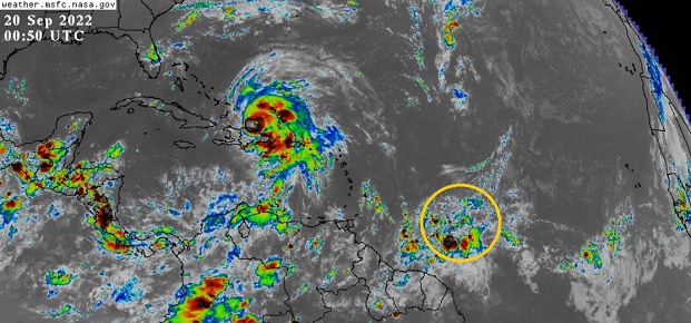
A stout wave presently located several hundred miles east of the Windward Islands is showing signs of sharpening, and based on modeling, will soon be encountering a more favorable region for development, and possibly a much more favorable region for development by week's end. This feature is not yet Invest tagged, but very well may be within the next day or two.
With this being peak season and the western Atlantic closer to land fairly primed for additional development, we are now starting a Forecast Lounge on this wave.
This will likely be given the Invest tag 98 later today or Wednesday. Overnight convection is flaring up well with continued sharpening of the axis.
(Invest 98L as of 9/20 12Z) - Ciel
Invest 98L became a tropical depression overnight Sep 22nd and the title has been updated accordingly. Ian at 11PM EDT 9/23- Ciel
Edited by cieldumort (Fri Sep 23 2022 10:55 PM)
|
MichaelA
Weather Analyst

Reged:
Posts: 952
Loc: Pinellas Park, FL
|
|
Models are pretty scattered on this in the long run. takes it into the Yucatan, ECWMF-operational takes it between Yucatan and Cuba, brings it to the Florida keys, and NAVGEM has it follow Fiona’s track. We’ll have to keep watching this one.
--------------------
Michael
PWS
|
IsoFlame
Weather Analyst

Reged:
Posts: 382
Loc: One block off the Atlantic Oce...
|
|
Fuel for the fire:
SST's
--------------------
CoCoRaHS Weather Observer (FL-VL-42) & Surf Forecaster: https://www.surf-station.com/north-florida-surf-forecast-3/
|
GeorgeN
Weather Watcher

Reged:
Posts: 39
Loc: Wesley Chapel FL
|
|
I've been following the predicted path on Windy.com; and the track just shifted from predicting the storm over Tampa (Thurs 29) to the storm out in Gulf (close to the predicted location). Did the predictions just shift? This occurred right around 2:00PM EST.
I'm tracking this one intensely because I live in North Tampa and may be heading to Biloxi next week. I don't want to have a storm chasing me.
--------------------
Wesley Chapel FL - since 1990
Previous resident of North Miami and Merritt Island
|
IsoFlame
Weather Analyst
Reged:
Posts: 382
Loc: One block off the Atlantic Oce...
|
|
The relatives used to book trips to Biloxi in September to take advantage of casino perks, bu no more following the recent hyper-active GOMEX hurricane seasons. To go this time of year is gambling against the odds! 
--------------------
CoCoRaHS Weather Observer (FL-VL-42) & Surf Forecaster: https://www.surf-station.com/north-florida-surf-forecast-3/
|
Kraig
Weather Hobbyist

Reged:
Posts: 86
Loc: Jupiter, Fl
|
|
The 12Z run of the euro just swung back to the FL peninsula just north of Tampa but as a much weaker storm than the current run...This would drive an awful lot of water up into the bay!
--------------------
2022 forecast 21/11/4; 0/0/0 as of 6/1
South FL Native: David ('79), Floyd ('87), Andrew ('92), Georges ('98), Irene ('99), Charlie, Frances & Jeanne ('04), Wilma ('05), Matthew ('16), Irma ('17), Dorian ('19) and Isaias (20)
|
GeorgeN
Weather Watcher
Reged:
Posts: 39
Loc: Wesley Chapel FL
|
|
Quote:
The 12Z run of the euro just swung back to the FL peninsula just north of Tampa but as a much weaker storm than the current run...This would drive an awful lot of water up into the bay!
I saw that change. Weird how the and Euro switched to each other's previous estimates. I suspect this has something to do with when they are run. I'm waiting till week's end to make a "go/ no go" on this trip
.
--------------------
Wesley Chapel FL - since 1990
Previous resident of North Miami and Merritt Island
|
MikeC
Admin
Reged:
Posts: 4690
Loc: Orlando, FL
|
|
This system has a few more days before it develops. Although once in the west Caribbean the upper air pattern for it is strikingly good on the models, so the intensity may be uncapped at least in that variable. Dry and land interaction may be the only thing holding it back. The models are shifting to basically somewhere in the Eastern Gulf, which could mean MS/AL/Panhandle or somewhere along the west coast of Florida. Although before anything has developed, I'd remain very cautions about inferring anything about exact track there. It'll likely get south of Grand Cayman and start turning north around then, if it goes over Cuba or through the Yucatan channel is unknown.
0GFZ currently has a landfall just west of Panama City Beach, Sep 30, Friday morning as a cat 4. This track will likely shift back and forth multiple times, potentially quite far one way or the other over the next week. So the only thing I can infer is the Keys and west Coast of Florida to Louisiana needs to watch this very closely.
0z EURO has a landfall Thursday morning in Naples after getting very close to Key West, as cat 3. After that crosses the state and exits somewhere around Melbourne then makes another landfall in Wilmington, NC.
0z Canadian ends in the Central Gulf on Sep 30th. (Which is a huge shift east from earlier where it wound up in the Bay of Campeche)
0z German Icon only goes out to the 28th, but it ends on the western tip of Cuba as a cat 3.
Remember these models are all over 5 days so not very reliable at this point for track OR intensity, especially for a system that has not developed yet and probably won't until it gets into the Caribbean in 2-3 days. Good for giving a sense of a good general area (being several states wide) to need to pay attention to.
The angle it which its coming from will making figuring out the exact track very difficult even very close to the landfall timeframe, especially if it winds up targeting the west coast of Florida. (See Hurricane for an example of that) Timeframe is late next week for Gulf/Florida. (Thur-Sat depending on exactly where it goes)
In the meantime Canada will be dealing with a very strong transitioning Fiona (Equivalent pressure typical to a cat 4 when it arrives in Nova Scotia).
|
cieldumort
Moderator
Reged:
Posts: 2522
Loc: Austin, Tx
|
|
Invest 98L's surface center has arguably remained more over northernmost South America, than over the Caribbean, and this land interaction coupled with debilitating outflow from Hurricane Fiona have been preventing the trof from developing, thus far. However, with the continued pull to just north of west, along with Fiona moving away, the likelihood of tropical cyclogenesis is easily pegged at 70% within 2 days and 90% within 5 days.
But we have questions.
It appears that many models have initialized 98L a little too far over open water. This may result in a rightward track bias. There remains a possibility that 98L tracks further west than currently advertised by whatever consensus currently exists. This is not a baseline scenario, but can not be ruled out.
Additionally, operational this season has proven to have a high development and intensification bias in the western Caribbean. Unsurprisingly, even early runs of on 98L have predicted a sub-940hPa Major. While definitely far more realistic a possibility than earlier in the season, one could say likely, it does yet cast doubt on the aggressive runs has put out so far, and also puts even more into question the forecast of a more right-leaning track, including the Florida peninsula, as a less robust cyclone may not pull so far to the right. Even if the system were to Major, if it doesn't major soon enough, this could still be more of a concern from Texas to the Florida panhandle than the Florida peninsula.
Realistically, this far out and without a solid cyclone yet to forecast off of, even Mexico is still in play, however unlikely.
These caveats aside, the baseline and more likely outcome is for the fledgling to really take off somewhere between the central and western to northwestern Caribbean in an environment of moderate to very low shear and high to very high ocean heat content, with long-range modeling still suggesting a tug into the central to eastern Gulf of Mexico.
Some Sep 22 0z runs
GFS - May have a reasonable initialization. Probably TD by late Thursday night/Friday morning. Tropical storm by Saturday night while in the central Caribbean. Hurricane by Monday morning in the northwestern Caribbean. Cat 2 or better on approach to northeastern/eastern Yucatan Tuesday morning (the 27th). Crosses northern Yucatan during the day Tuesday as high-end Tropical Storm to Hurricane. Becomes a sizeable and powerful Cat 2+ hurricane in the central Gulf mid to late next week on approach to Louisiana, with a landfall in central Louisiana early Sunday, October 2nd.
HMON - Looks to have initialized too much over open water. TD by later this morning or early afternoon (Thursday, 22nd). Tropical Storm by Sunday morning while in the west-central Caribbean. Hurricane by Monday morning in the northwestern Caribbean. End of this model's run as a Cat 2 on approach towards the northeastern Yucatan.
HWRF - Initialized a bit much northeast, over water and already organizing. Tropical Storm as of this hour in the extreme southern Caribbean, with the cyclone then seeming to struggle until it reaches the west-central Caribbean. Hurricane by midday Sunday in the western Caribbean. Majors in the northwestern Caribbean Monday morning. Cat 4 by Monday night. Deepening Cat 4+ near 20.5N 85W at the end of this model's run predawn Tuesday the 27th.
|
MikeC
Admin
Reged:
Posts: 4690
Loc: Orlando, FL
|
|
Morning Models
The 6z gets over the Yucatan Peninsula and back over the open Gulf where it moves somewhat slowly and landfalls south of Lake Charles Sunday afternoon on October 2nd. The Seems to be alone that far west. The 0z Canadian GEM (CMC) model takes it over Naples, FL this Coming Tuesday as a category 2 hurricane. The 0z Euro landfalls north of Tampa near Cedar key Thursday morning as a cat 3/4 hurricane. The UKMET and TVCN consensus (NHC is usually close to it) have it in the East Gulf generally toward the Florida panhandle.
Without a definite center to track and it being so close to south America, there's still a great deal of uncertainty right now, but seems to be the outlier at the moment.
|
GeorgeN
Weather Watcher
Reged:
Posts: 39
Loc: Wesley Chapel FL
|
|
The Euro model just appeared on the charts, Now swinging West with the storm clipping the West edge of Cuba, going North then East, coming into Florida around Cedar Key on Thursday afternoon. It will probabaly be late this weekend before we see any definitive convergence of the models (maybe).
--------------------
Wesley Chapel FL - since 1990
Previous resident of North Miami and Merritt Island
|
IsoFlame
Weather Analyst
Reged:
Posts: 382
Loc: One block off the Atlantic Oce...
|
|
98-L hasn't developed a well-defined circulation (just yet) to track, and there is no mention of forward speed of the system (as a whole) in the discussion. Sat loop suggests currently moving W/WNW at a pretty good pace while embedded in moderate/strong easterlies.
While I find it hard (ATM) to get on board with the most aggressive models forecasting rapid intensification to a Major 5+ days out, once (if) 98-L gets clear of land and in a lower shear environment while slowing over the high/deep available oceanic energy in the western Caribbean, in total agreement that impressive intensification will be likely.
--------------------
CoCoRaHS Weather Observer (FL-VL-42) & Surf Forecaster: https://www.surf-station.com/north-florida-surf-forecast-3/
Edited by IsoFlame (Thu Sep 22 2022 08:40 AM)
|
Kraig
Weather Hobbyist
Reged:
Posts: 86
Loc: Jupiter, Fl
|
|
Agreed...The outflow from Fiona seems to be holding 98L back for the time being, and that alone may be the thing that saves peninsular Florida and sends the potential storm further west into the central Gulf. I hope they keep sending at least one recon plane in a day to collect data, preferably a high altitude GIV to continue feeding some really great data into the models.
|
cieldumort
Moderator
Reged:
Posts: 2522
Loc: Austin, Tx
|
|
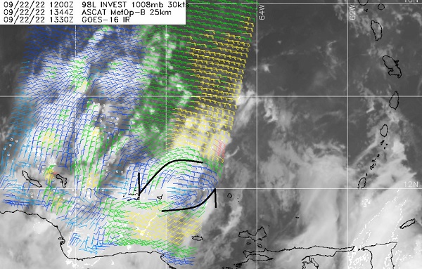
A nascent LLC can be seen in the most recent ASCAT pass from this 1344z this morning at approximately 11.8N 65.5W. This low-level spin was also discernible in select IR channels already over water predawn today, and looks to have become dominant, with the preexisting low level spin that was centered inland not nearly as obvious now, and appears to be getting entrained into this new 'center.' While elongated and not fully closed off, it looks solid enough for 98L to try to build on, and a tropical cyclone may be forming today.
|
MikeC
Admin
Reged:
Posts: 4690
Loc: Orlando, FL
|
|
0z models:
Trend here is SW Florida, but SLOW moving once landfall happens so it affects a lot of Florida. Rainfall totals are extreme.
GFS:
Clips W. Cuba as a cat 2/3 Monday night,
Landfall between Englewood and Venice, FL Wednesday morning cat 3/4. Moves very Slowly over Florida (extreme rainfall amounts). Exits Vero Beach Thursday midday. Loops back,. landfall near Hilton Head Island, on Friday night, then moves inland toward Columbia, SC.
Icon:
Moves over Cuba midday Tuesday, very clo0se or over Key West early Wednesday morning as a cat 2/3, Naples Midday Wednesday as a cat 2/3. Rides slowly up through Florida and Exits at Cape Canaveral midday friday.
CMC:
West cuba Monday night cat 2. Fort Myers, Cat 2/3 predawn Wednesday morning. Stalls over or just east of Tampa for most of Wednesday and thursday. Slides north, gets into Georgia Friday Afternoon.
|
craigm
Storm Tracker

Reged:
Posts: 327
Loc: Palm City, Florida
|
|
Quote:
0z models:
Trend here is SW Florida, but SLOW moving once landfall happens so it affects a lot of Florida. Rainfall totals are extreme.
GFS:
Clips W. Cuba as a cat 2/3 Monday night,
Landfall between Englewood and Venice, FL Wednesday morning cat 3/4. Moves very Slowly over Florida (extreme rainfall amounts). Exits Vero Beach Thursday midday. Loops back,. landfall near Hilton Head Island, on Friday night, then moves inland toward Columbia, SC.
Icon:
Moves over Cuba midday Tuesday, very clo0se or over Key West early Wednesday morning as a cat 2/3, Naples Midday Wednesday as a cat 2/3. Rides slowly up through Florida and Exits at Cape Canaveral midday friday.
CMC:
West cuba Monday night cat 2. Fort Myers, Cat 2/3 predawn Wednesday morning. Stalls over or just east of Tampa for most of Wednesday and thursday. Slides north, gets into Georgia Friday Afternoon.
Hope they are paying attention in the Keys being, at a minimum, on the dirty side of the storm or worse. Looking a lot like Charlie and Wima
--------------------
Why I'm here:
Weather hobbyist
|
IsoFlame
Weather Analyst
Reged:
Posts: 382
Loc: One block off the Atlantic Oce...
|
|
Quote:
Quote:
0z models:
Hope they are paying attention in the Keys being, at a minimum, on the dirty side of the storm or worse. Looking a lot like Charlie and Wima
...but slower (hence much wetter)
--------------------
CoCoRaHS Weather Observer (FL-VL-42) & Surf Forecaster: https://www.surf-station.com/north-florida-surf-forecast-3/
|
MikeC
Admin
Reged:
Posts: 4690
Loc: Orlando, FL
|
|
The 0z euro is slower than yesterday's 12Z, crosses Cuba Tuesday morning as a cat 1, then arrives in southwest Florida, near Marco Island, early Wednesday instead of Tuesday night cat 1 . It moves quickly through the state and leaves near Fort Pierce. Then cliips the outer Banks and heads to Long Island.
6Z clips Western Cuba as a Cat 3/4 late Monday night. Landfall near Bradenton as a cat 3 Wednesday afternoon. Would push water up Tampa Bay. Just south of Orlando Thursday Morning, gets into the Atlantic near Palm Bay Friday morning. (Spends all day Thursday OVER central Florida) loops over the Atlantic, Heads back southwest and landfalls near Jupiter (much weaker, TD) on Oct 5 then gets back into the gulf.
|
MichaelA
Weather Analyst
Reged:
Posts: 952
Loc: Pinellas Park, FL
|
|
Waiting for the 12Z model runs to see if there is more convergence. Still not clear until possibly 72 hours out. The entire peninsula of Florida should be paying close attention and checking storm preparations.
--------------------
Michael
PWS
|
Wingwiper
Verified CFHC User
Reged:
Posts: 14
Loc: Florida
|
|
"The entire peninsula of Florida should be paying close attention and checking storm preparations." As someone who rode out Charlie (that was supposed to go elsewhere) in my closet, that's the best advice of all.
|


 Threaded


