GeorgeN
Weather Watcher

Reged:
Posts: 39
Loc: Wesley Chapel FL
|
|
Tracking seems to indicate a strong NE direction, with perhaps some speed increase. The 17:00 update should be interesting as the 1200Z tracks have all posted. Seems that the UKMET called it correctly and didn't waiver. Still researching why it was so accurate. I give points to the Euro, but it pulled North several times.
Cuba's mountains did pull some speed off the storm, but alas it cut across the narrows of the island too quickly. Reports are saying 1 million Cubans are without power. Puerto Rico suffered less as it was a Cat1 storm at the time. Still they are having power issues. Even though 3 billion dollars were allocated after hurricane Maria, PR's status as an unincorporated territory make it difficult for the US to fund critical projects without corruption. (for more info - see Luma Energy scandal)
--------------------
Wesley Chapel FL - since 1990
Previous resident of North Miami and Merritt Island
|
JMII
Weather Master

Reged:
Posts: 546
Loc: Cape Coral & Margate, FL
|
|
Yep its been tracking NNE all day, in the last few frames on radar it jogged more N. Looking at the water vapor loop the front is strong and digging in across AL and MS. Ian about to run into a wall thus I don't see it making it to Tampa given the overall environmental conditions. The has moved the track S again. The track was N of Sarasota County at 5AM, 12 hours later at 5PM its S of Sarasota County. I hate referencing but fear the focus on Tampa might be overstated... again. In 24 hours this thing will be on top of Ft Myers.
BTW the interactive map is great especially with the wind radii overlay...
Ian will go right over Dry Tortugas so we should get some good data then.
--------------------
South FL Native... experienced many tropical systems, put up the panels for:
David 79 - Floyd 87 - Andrew 92 - Georges 98 - Frances 04 - Wilma 05 - Matthew 16 - Irma 17
Lost our St James City rental property to Ian 22
|
MichaelA
Weather Analyst

Reged:
Posts: 952
Loc: Pinellas Park, FL
|
|
The 5PM package has reflected the more eastward track and has accelerated the overall forward speed and intensity at landfall probably between Englewood and Punta Gorda as a Cat 4 storm. Tampa Bay remains in the northern part of the cone, though. It’s too early to breathe a sigh of relief.
--------------------
Michael
PWS
|
Psyber
Storm Tracker

Reged:
Posts: 239
Loc: Ontario, Canada
|
|
Quote:
The 5PM package has reflected the more eastward track and has accelerated the overall forward speed and intensity at landfall probably between Englewood and Punta Gorda as a Cat 4 storm. Tampa Bay remains in the northern part of the cone, though. It’s too early to breathe a sigh of relief.
Not good because the jet stream's incoming dry air favours Ian to stay offshore as long as possible so to seriously hit it with its dry air.
I can't help thinking that this is like a drag race. A wobble or two east, and tit hits southern Florida as a potentially strong H4. Staying West, it'll have more time to get hit by the incoming change to the jet stream, but it'll still hit somewhere like Tampa Bay pretty hard and with storm surge to some pretty vulnerable shoreline.
Radar shows what looks like an eyewall replacement. 
--------------------
The safest way to deal with a potential Hurricane hitting you...is to leave and just not be there at all.
Edited by Psyber (Tue Sep 27 2022 07:22 PM)
|
JMII
Weather Master
Reged:
Posts: 546
Loc: Cape Coral & Margate, FL
|
|
8PM update finally lists motion as NNE.
Ian is 65 to 70 miles due W of Key West where they are currently experiencing 40 to 55 MPH winds.
Pressure down to 947. Might be going thru an as the eye is looking a bit messy.
|
Psyber
Storm Tracker
Reged:
Posts: 239
Loc: Ontario, Canada
|
|
LOL do you realize that you registered here ONE DAY before me, 15 years ago? LOL.
Yes, I saw the EW start to barf around 6 but not much of an outer band. As it is now, that outer band is absolutely going to commit fratricide sometime in the next couple hours.
Edited by Psyber (Tue Sep 27 2022 09:34 PM)
|
MichaelA
Weather Analyst
Reged:
Posts: 952
Loc: Pinellas Park, FL
|
|
Current radar loop indicates that the is nearly complete. I wonder if further intensification will resume now. If the present projected course verifies, the winds at Tampa Bay will be from the NE draining the bay rather than flooding it.
--------------------
Michael
PWS
|
JMII
Weather Master
Reged:
Posts: 546
Loc: Cape Coral & Margate, FL
|
|
Quote:
LOL do you realize that you registered here ONE DAY before me, 15 years ago? LOL.
WOW that is crazy.
Anyway...
Not much moisture content in the SE quad, just one or two feeder bands, the system is struggling to wrap its available energy into the core. As the eyewall comes back from this ragged condition it looks larger indicating an expanding wind field but with higher pressure. I am starting to sound like a broken record but Ian continues to favor the E side of the forecast cone.
All models are coming into agreement on a landfall around Port Charlotte, with UK going even further S down to Bonita Springs. Also the intensity forecast is showing we have reached peak strength with a weakening trend towards landfall (hopefully sooner rather then later). Ian is getting squeezed between the front to the north and a high building in from the east which is keeping him in check and driving future NE motion.
The 11PM update should be interesting.
|
cieldumort
Moderator

Reged:
Posts: 2529
Loc: Austin, Tx
|
|
Here's a rundown of the 0928 0z runs
Globals:
ECMWF - Landfall just north of Cape Coral around 2PM EDT today, 946mb Major Hurricane. Slowly tracks NNE and just south of Deltona middle of the day Thursday 990mb and dumping a swath of over 20" of rain accumulation to this point between roughly Bradenton to Lakeland. Emerges along the east coast of the state between Titusville and Daytona beach around 8PM EDT Thursday, 988mb, reintensifying. Gradually tracks generally northward just offshore of the east coast and is east of Jacksonville by 10AM EDT Friday, 986mb and continuing to intensify into another landfall southeast of Savannah, GA around 9PM EDT Friday night, 984mb.
UKMET - Landfall roughly between Cape Coral and Port Charlotte about 3PM EDT today, 971mb, and rising. This is an incredibly sensitive area for surge and this rising min pressure in this run only spreads the winds out and increases the surge. Exits the state just east of Titusville about noon Thursday, 992mb, leaving a swath of 12" to 20" cutting sw to ne across the middle of the state. Second landfall NE of Charleston, SC about 5PM EDT Friday, 982mb.
GFS - Landfall west of Port Charlotte 960mb 4PM EDT today. Exits the state just east of Titusville about 4AM EDT Friday, 989mb, by this time leaving a huge swath of 20" to low 30s" from around Bradenton to Daytona Beach. Runs generally northish offshore east coast of Florida, makes another landfall between roughly Savannah, GA and Beaufort, SC about 9PM EDT Friday, 985mb.
ICON - Landfall just west of Cape Coral 953mb around 1PM EDT today. Has a second landfall about 9PM EDT Friday just east of Charleston, SC 966mb, Major.
|
IsoFlame
Weather Analyst

Reged:
Posts: 384
Loc: One block off the Atlantic Oce...
|
|
Quote:
Here's a rundown of the 0928 0z runs
Globals:
ECMWF - Landfall just north of Cape Coral around 2PM EDT today, 946mb Major Hurricane. Slowly tracks NNE and just south of Deltona middle of the day Thursday 990mb and dumping a swath of over 20" of rain accumulation to this point between roughly Bradenton to Lakeland. Emerges along the east coast of the state between Titusville and Daytona beach around 8PM EDT Thursday, 988mb, reintensifying. Gradually tracks generally northward just offshore of the east coast and is east of Jacksonville by 10AM EDT Friday, 986mb and continuing to intensify into another landfall southeast of Savannah, GA around 9PM EDT Friday night, 984mb.
UKMET - Landfall roughly between Cape Coral and Port Charlotte about 3PM EDT today, 971mb, and rising. This is an incredibly sensitive area for surge and this rising min pressure in this run only spreads the winds out and increases the surge. Exits the state just east of Titusville about noon Thursday, 992mb, leaving a swath of 12" to 20" cutting sw to ne across the middle of the state. Second landfall NE of Charleston, SC about 5PM EDT Friday, 982mb
Above model location and timing with tidal cycle not good for Fort Myers area:
afternoon high tides near forecast time of landfall
Also, high tides up the bay from the entrance will be later in the afternoon, possibly around the time of peak surge, exacerbating and prolonging estuary flooding.
Only "positives": I can come up with in these model scenarios:
Ian may be slightly weaker than Cat 4 5AM advisory (though still a strong 3) just ahead of landfall due to possible erosion of east side of eye wall from land interaction.
Daytime landfall = less hazardous than night for those who did not heed evacuation order, and daytime high tide is up to 6" lower than night.
--------------------
CoCoRaHS Weather Observer (FL-VL-42) & Surf Forecaster: https://www.surf-station.com/north-florida-surf-forecast-3/
Edited by IsoFlame (Wed Sep 28 2022 06:30 AM)
|
cieldumort
Moderator
Reged:
Posts: 2529
Loc: Austin, Tx
|
|
The intensities from those global runs are trash. Helpful for track, however.
|
cieldumort
Moderator
Reged:
Posts: 2529
Loc: Austin, Tx
|
|
6:30 Update advisory 155 MPH and this could be a touch conservative. Ian is effectively a Cat 5 heading into landfall.
|
JMII
Weather Master
Reged:
Posts: 546
Loc: Cape Coral & Margate, FL
|
|
Ian has a very odd structure, when the eyewall finally reformed it got bigger but the wind field didn't expand. The system doesn't have a traditional core - instead is just one big eyewall  the center is 35-40 miles from Sanibel yet winds are only blowing in the 40-60 mph range there (for now). However just 20 miles offshore the wind is blowing 150. Ian is managing to fight off the dry air to its NW but the squeeze between the two high pressure system is has increased its rotational speed resulting in incredible Cat 4+ winds. The current environmental conditions have managed to concentrate all the energy into a narrow but very destructive ring. the center is 35-40 miles from Sanibel yet winds are only blowing in the 40-60 mph range there (for now). However just 20 miles offshore the wind is blowing 150. Ian is managing to fight off the dry air to its NW but the squeeze between the two high pressure system is has increased its rotational speed resulting in incredible Cat 4+ winds. The current environmental conditions have managed to concentrate all the energy into a narrow but very destructive ring.
My sister in law has a rental mobile home on Pine Island in St James City that I use as a fish camp during the summer, at this rate I can only assume it will be gone nobody is there now, she lives in Davie with my brother and is safe.
--------------------
South FL Native... experienced many tropical systems, put up the panels for:
David 79 - Floyd 87 - Andrew 92 - Georges 98 - Frances 04 - Wilma 05 - Matthew 16 - Irma 17
Lost our St James City rental property to Ian 22
|
JMII
Weather Master
Reged:
Posts: 546
Loc: Cape Coral & Margate, FL
|
|
Eye wrapping up and becoming tighter - almost a solid circular wall now  Hurricane force winds in Sanibel /St James City / Boca Grande. Movement just north of NNE. Englewood could be ground zero. Hurricane force winds in Sanibel /St James City / Boca Grande. Movement just north of NNE. Englewood could be ground zero.
|
JMII
Weather Master
Reged:
Posts: 546
Loc: Cape Coral & Margate, FL
|
|
Backside of the eye building up, tons of lighting on front side... slight E wobble - Boca Grande for landfall. Sanibel entering the eyewall now.
|
Owlguin
Weather Hobbyist
Reged:
Posts: 73
|
|
This thing will come ashore in the Captiva/Cape Coral area. It didn’t listen to the models at all the past week.
|
GeorgeN
Weather Watcher
Reged:
Posts: 39
Loc: Wesley Chapel FL
|
|
Quote:
This thing will come ashore in the Captiva/Cape Coral area. It didn’t listen to the models at all the past week.
UKMET was plotting Venice since Sunday. Not sure why, but that plot was almost spot on and stayed constant the whole time.
--------------------
Wesley Chapel FL - since 1990
Previous resident of North Miami and Merritt Island
|
Owlguin
Weather Hobbyist
Reged:
Posts: 73
|
|
I guess it is coming in within the cone area too.
|
JMII
Weather Master
Reged:
Posts: 546
Loc: Cape Coral & Margate, FL
|
|
Quote:
This thing will come ashore in the Captiva/Cape Coral area. It didn’t listen to the models at all the past week.
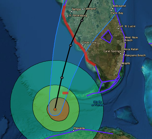
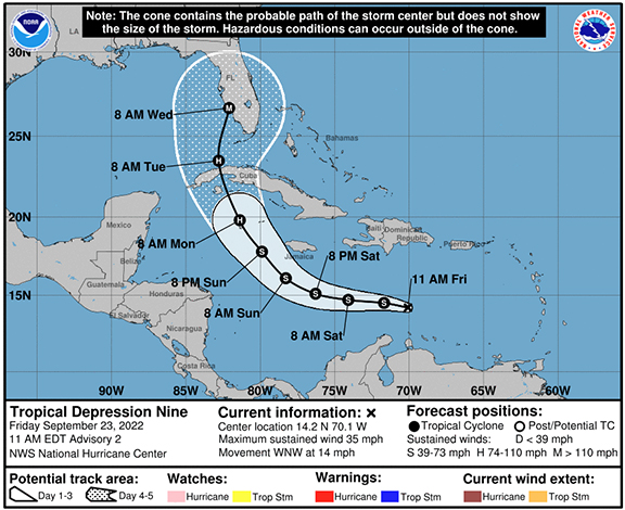
Check Advisory #2 (shown below) released last Friday - Cat 3 on top of Cape Coral at 8AM today. Cape Coral was never outside the cone, granted it was the SE edge of guidance, and of course everyone focused on Tampa, but as mentioned above the UK had this track figured out.
|
JMII
Weather Master
Reged:
Posts: 546
Loc: Cape Coral & Margate, FL
|
|
Landfall 3:05 PM Cayo Costa winds 150 mph pressure 940 mb
Based on videos and other data there is some really bad surge south of center - the water level in Naples is 7 feet above high tide and that is open beach not a cove or bay where water can truly pile up.
|


 Threaded


