MikeC
Admin
Reged:
Posts: 4545
Loc: Orlando, FL
|
|
Just kicking this off since a few folks have emailed me about the recent runs, in short, it's not likely. More likely is something in the east pacific out of this. Particularly since euro and Canadian don't show a hint of anything in the West Caribbean. A lot of it is the overdoing what's over Venezuela.
|
IsoFlame
Weather Analyst

Reged:
Posts: 295
Loc: One block off the Atlantic Oce...
|
|
Though an outlier, the has been remarkably consistent all week with the spin up. Leaves one to wonder when it will back off or the other models might come on board..
|
MikeC
Admin
Reged:
Posts: 4545
Loc: Orlando, FL
|
|
The has been consistently wrong in this region, it did this quite a bit last year in this same area as well. has it's uses, but it really does have a persistent problem with the Central American Gyre and Venezuela. Not one of the European ensembles shows anything either. East Pacific is the more likely situation. It'll be interesting to see when the stops showing this. Central America will likely get a lot of rain either way.
|
MikeC
Admin
Reged:
Posts: 4545
Loc: Orlando, FL
|
|
The area in the MDR may be the next thing to show up, is gradually shifting itself west/weaker inland which means a lot of rain for Central America, but the Euro and a few other things are picking up on something approaching the Leeward islands toward the end of the run.
|
IsoFlame
Weather Analyst
Reged:
Posts: 295
Loc: One block off the Atlantic Oce...
|
|
Quote:
The has been consistently wrong in this region, it did this quite a bit last year in this same area as well. has it's uses, but it really does have a persistent problem with the Central American Gyre and Venezuela. Not one of the European ensembles shows anything either. East Pacific is the more likely situation. It'll be interesting to see when the stops showing this. Central America will likely get a lot of rain either way.
Thanks for the insight. 12Z did back off significantly on timing/development and ultimate fate if anything is able to spin up. instead (like you mention) lots of moisture associated with the gyre soaks C. America, and moisture also streams NE across Cuba/S. Fla into the Bahamas.
What are the reasons for the to have problems with the gyre, often overachieving development in the region?
I like to use the for medium range forecasts because even though it often cries "wolf", it can give a "heads up" days in advance of the other models.
--------------------
CoCoRaHS Weather Observer (FL-VL-42) & Surf Forecaster: https://www.surf-station.com/north-florida-surf-forecast-3/
|
IsoFlame
Weather Analyst
Reged:
Posts: 295
Loc: One block off the Atlantic Oce...
|
|
Quote:
The area in the MDR may be the next thing to show up, The Euro and a few other things are picking up on something approaching the Leeward islands toward the end of the run.
Noted.
I haven't been paying much attention to the Atlantic this early in the season. As the central Atlantic high builds through next week, a large westward moving tropical wave progresses along the underbelly of the ridge will be worth watching.
--------------------
CoCoRaHS Weather Observer (FL-VL-42) & Surf Forecaster: https://www.surf-station.com/north-florida-surf-forecast-3/
|
MikeC
Admin
Reged:
Posts: 4545
Loc: Orlando, FL
|
|
The 6z is now again showing something in the W Carib in less than 7 days, however it's still alone. I still think it's overdoing it.
The MDR region in the central Atlantic still has a better shot next week of seeing something, even if it winds up being very sloppy development.
Two areas in the Eastern Pacific are up on the , however.
|
MikeC
Admin
Reged:
Posts: 4545
Loc: Orlando, FL
|
|
The12Z Euro is showing a potential TS on approach to the eastern Caribbean islands next Wed/Thursday.
|
MikeC
Admin
Reged:
Posts: 4545
Loc: Orlando, FL
|
|
The area mentioned leaving Africa heading to the Atlantic now has a 20% chance to develop over the next 7 days.
New Lounge topic for this system https://flhurricane.com/cyclone/showflat.php?Cat=0&Number=114567&page=0&vc=#Post114567
Edited by CFHC (Thu Jun 15 2023 02:05 PM)
|
CFHC

Reged:
Posts: 149
Loc: East Central Florida
|
|
12z brings a system into SW Florida in about 6 days, still seems false/spurious, but getting in the range where it still needs to be watched.
|
Robert
Weather Analyst

Reged:
Posts: 364
Loc: Southeast, FL
|
|
I don't think anyone should be throwing out the Caribbean system just yet, I know the is iffy, but its persistent. And some years does okay sniffing stuff out. There currently Is persistent ball of convection that looks to be at least trying to spin up with a center reformation offshore, that looks almost good , to better then what is out there..if it continues , I could see Bret going to the Caribbean and Cindy to 92L.. also just tagged the wave behind 92L
Edited by Robert (Sun Jun 18 2023 11:58 PM)
|
MikeC
Admin
Reged:
Posts: 4545
Loc: Orlando, FL
|
|
After a solidly quiet July other than Don, some of the ensembles are hinting at some activity near or just north of the Caribbean is about 10 days time. Worth monitoring to see if anything materializes. Shear may be high to keep anything forming down.
|
MikeC
Admin
Reged:
Posts: 4545
Loc: Orlando, FL
|
|
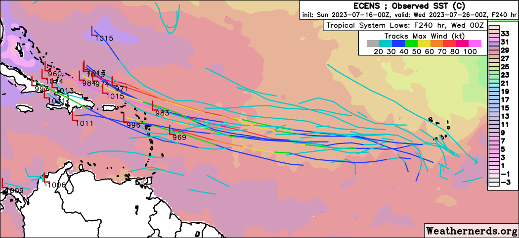
12z has this system becoming a hurricane north of the Caribbean between Cuba and Andros island then moves it over or near Key West July 29th as a cat 2 (probably understated if it goes that path) then ends the run in the Central Gulf. has been a bit off this year, but this area is not as known for "phantoms" as the west Caribbean.
The 12Z Canadian takes it right into the Caribbean and doesn't get stronger. 0z Euro has it north of the Caribbean but much weaker (Although some of the ensembles are much stronger).
With some ensemble support from the euro, this mdr system is likely to be worth watching to see if this persists or fades over the coming week or so. Way too early to speculate on where, although we'll mention what the operational models suggest regardless. (Just know at this far out it's extremely unlikely)
12z EURO doesn't really pick up the system like the 12Z does out to 240 hours. (Weak wave approaching the E. Caribbean on July 24th is the only real identity on the euro operational) However some of the ensembles do pick it up more.
Probably the biggest reason it wouldn't develop is mid level dry air, so right now the more likely scenario is that this system won't be able to get going.
|
MikeC
Admin
Reged:
Posts: 4545
Loc: Orlando, FL
|
|
Overnight model runs shifted a bit right for the , the latest (6z)takes a path away form the Caribbean and US, while the 0z ended with a much stronger hurricane closer to the US. (Yesterday was the Gulf). The swings will likely continue.
Euro doesn't develop the system, but gets the wave into the Caribbean. It's also moves the system much faster to the west.
Canadian does not develop it.
Still plenty of time to watch, but until the system is off Africa and the models go one way or the other, it's nothing more than something to monitor into later this week. On the ensemble runs, Euro and do show a potential for something toward the Caribbean. But of the operational, only the does.
Edited by CFHC (Mon Jul 17 2023 03:21 PM)
|
MikeC
Admin
Reged:
Posts: 4545
Loc: Orlando, FL
|
|
Mixed models today, 12Z had a major hurricane entering the bahamas in the long range, while the 18Z now has it a weak wave in the Bahamas. The is much slower than the Euro, however, which has it entering the Caribbean as a wave.
BEuro Ensembles are spread out, however. 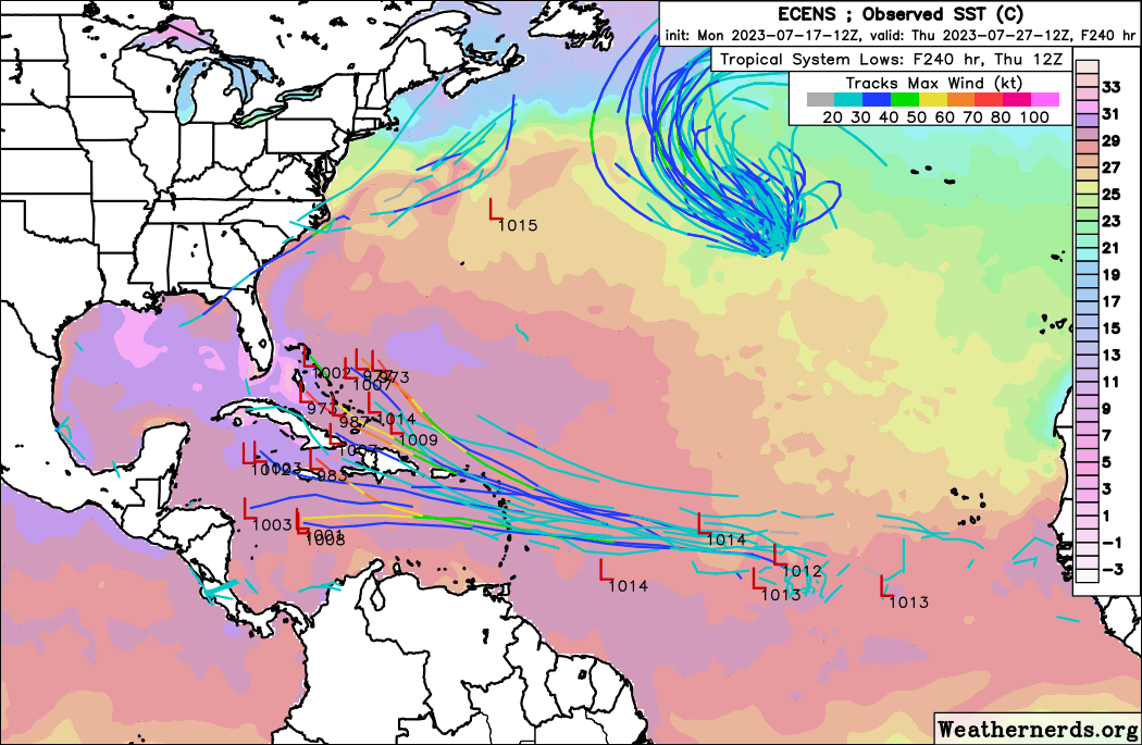
Bottom line, something to watch later this week into next week, but nothing concerning yet.
|
MikeC
Admin
Reged:
Posts: 4545
Loc: Orlando, FL
|
|
Overnight model runs have backed off on this wave somewhat. 0z kept it weak and turned it out to sea, while the 6z flipped all the way to a system going through the Caribbean and entering the Gulf west of Cuba, but weak.
0z Euro keeps it very weak through the Caribbean into Central America. Canadian shows much the same.
both euro and ensembles have less members showing development than before. Still early, but this morning it seems less likely anything will develop from it.
|
MikeC
Admin
Reged:
Posts: 4545
Loc: Orlando, FL
|
|
12Z has backed off even more with no development of the wave. 12Z euro has more of a signal than the . Ensembles have also backed off (although the euro ensembles have added a few members that show development). Chances are pretty low anything develops out of this. Dry air affecting this mostly, however it's enough to keep watch on over the next week or so to see if anything consolidates.
|
IsoFlame
Weather Analyst
Reged:
Posts: 295
Loc: One block off the Atlantic Oce...
|
|
Way, way off.... but any thoughts on the next area coming off Africa next week, plodding across the tropical Atlantic- last several runs have it tracking NW in our general direction, re-curving in the western Atlantic while strengthening into a hurricane, possibly brushing the Carolinas in early August.
My gut feeling was and still is for a significant (possibly major) hurricane in the western Atlantic in early to mid-August, with track and landfall potential dependent on the strength (or lack there of) of the western extension of the Atlantic ridge.
--------------------
CoCoRaHS Weather Observer (FL-VL-42) & Surf Forecaster: https://www.surf-station.com/north-florida-surf-forecast-3/
|
Robert
Weather Analyst
Reged:
Posts: 364
Loc: Southeast, FL
|
|
Anyone alive, there is activity?...GFS Euro,Nogaps 850 vort shows energy possibly crossing Florida on friday.. sattelite looks better then anything out there.. could be a depression or storm by the time it reaches the coast or get going if it enters the gulf, water temps through the roof?
|
IsoFlame
Weather Analyst
Reged:
Posts: 295
Loc: One block off the Atlantic Oce...
|
|
This is the one that we may need to closely monitor starting next weekend:
Tropical Weather Outlook
NWS National Hurricane Center Miami FL
800 AM EDT Wed Jul 26 2023
For the North Atlantic...Caribbean Sea and the Gulf of Mexico:
Eastern Atlantic:
A tropical wave is located just to the southwest of the Cabo Verde
Islands. Some development of this system is possible later this
week and into the weekend while it moves westward to
west-northwestward over the tropical Atlantic.
* Formation chance through 48 hours...low...near 0 percent.
* Formation chance through 7 days...low...30 percent.
--------------------
CoCoRaHS Weather Observer (FL-VL-42) & Surf Forecaster: https://www.surf-station.com/north-florida-surf-forecast-3/
|


 Threaded


