cieldumort
Moderator

Reged:
Posts: 2517
Loc: Austin, Tx
|
|
Increasingly, models are warming up to the idea of a tropical cyclone forming somewhere off Central America either in or moving into the Atlantic side later this week.
ECMWF ensemble implied formation probability is up around 65%. On the other hand, the operational runs of the have been inconsistent, tending to keep this Low on the weak side and linger it around the Yucatan without much development, and the operational washes it out over central Amerca by the weekend.
Overall, conditions remain favorable for tropical cyclone development in the Atlantic basin. Given this background state, model support and forecast locaton we are now starting a Lounge at this time on what is not yet Invest-tagged, but could be in a few days. Should this feature be assigned an Invest number the title will be updated.
There is a high chance that this well-forecast area of low pressure brings inclement weather to locations in and around the Western Caribbean to southern Gulf of Mexico, and based on modeling, a modest chance that it influences or impacts Florida by next week.
The area of interest in the northwest Caribbean has been assigned an Invest tag today, 93L, and the title has been updated accordingly.
TEN 8/26/23 5PM EDT - Ciel
Edited by MikeC (Sun Aug 27 2023 11:25 AM)
|
cieldumort
Moderator
Reged:
Posts: 2517
Loc: Austin, Tx
|
|
23/12z Operational has joined with so many of its ensemble members and develops. By the end of the day Friday, this model run shows a well-defined closed low established off the north coast of Honduras, tracks north to the northern portions of the Yucatan overnight Saturday as an apparent T.D. and very slowly drifts off the tip into the gap between Yucatan and western Cuba by Monday as a strengthening tropical storm, picking up speed later in the day Monday towards the north-northeast. Landfall Wednesday morning as a Cat 2+ hurricane near Bonita Beach, Fl.
|
bob3d
Weather Hobbyist

Reged:
Posts: 61
Loc: Pasco County, Florida
|
|
I do not see how this potential disturbance can possibly wind itself up to a Cat 2+ hurricane with the amount of upper level sheer that the GOM is experiencing right now.
--------------------
bob
Time in West Central Florida: 51 years
|
cieldumort
Moderator
Reged:
Posts: 2517
Loc: Austin, Tx
|
|
Here is the model sounding forecast for shear over the vortext on Tuesday 8/29/21z. The high shear outside of the vortex is largely due to the upper-level outflow, which is favorable for strengthening. Right over the vortex, this model forecast anticipates low deep layer shear at this time (just 13 knots).
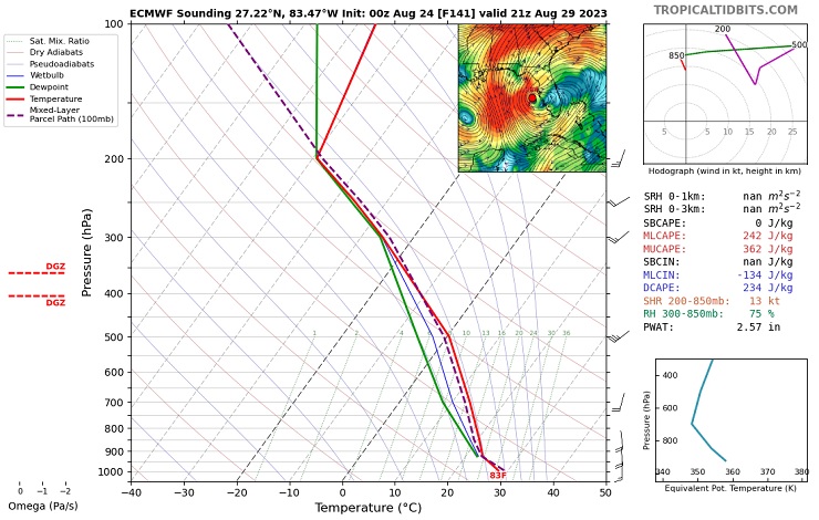
Graphic cr. TropicalTidbits
|
cieldumort
Moderator
Reged:
Posts: 2517
Loc: Austin, Tx
|
|

A small area of low pressure has formed in association with a quasi Central American Gyre. This compact area of low pressure is just off the northeastern tip of Honduras this evening, and is the most likely candidate swirl for initiation in the 70% probability cone, although it may jump north to north-northwest in the shorter-term. Longer-term and overall, a motion to the north-northeast to northeast is largely anticipated by models as the low organzies and begins to round the base of a small upper-level low to its northeast (model differences remain on placements and interactions).
|
cieldumort
Moderator
Reged:
Posts: 2517
Loc: Austin, Tx
|
|
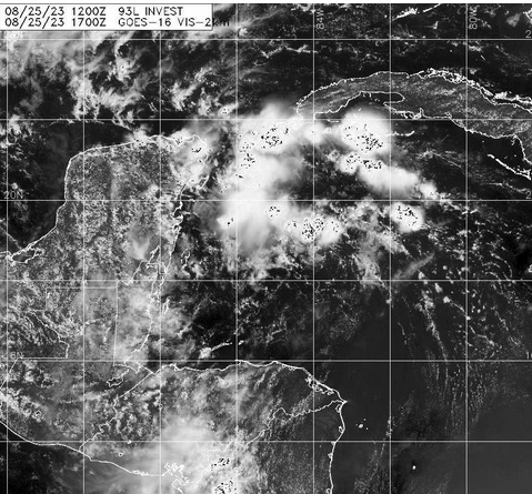
Above: 93L Visible 8/25/23/1700z
|
OrlandoDan
Weather Master

Reged:
Posts: 456
Loc: Longwood, FL
|
|
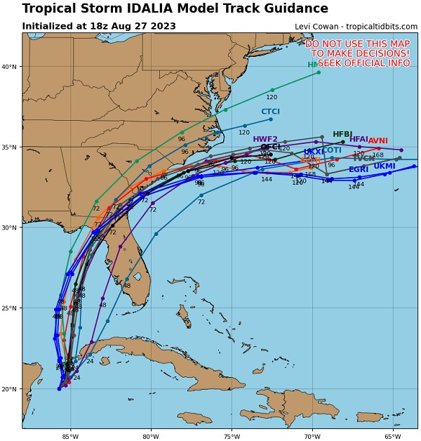
GFS and the Euro both are in agreement on the approximate path.
--------------------
Keith (1988), Charley (2004), Frances (2004) , Jeanne (2004), Fay (2008), Mathew (2016), Irma (2017), Dorian (2019)
Personal Weather Station: https://www.wunderground.com/dashboard/pws/KFLLONGW67
|
MikeC
Admin
Reged:
Posts: 4671
Loc: Orlando, FL
|
|
18z Icon shifted right to Sarasota (Was Steinhatchee at 12Z) on Tuesday evening
12z Euro shows Strong TS/Cat 1 Landfall Cedar Key Wednesday morning.
12gfs shows a cat 2 into Panama City Beach on Wednesday morning
18gfs shows a cat 2 into Apalachicola midday Wednesday (a bit right of and later than 12Z)
12z Ukmet shows a landfall on New Port Richey Tuesday night.
12z Canadian shows Cat1 landfall near Apalachicola.
|
MikeC
Admin
Reged:
Posts: 4671
Loc: Orlando, FL
|
|
Hurricane models
18z HMON cat 2 landfall just east of Apalachicola early Wednesday morning
18z HWRF cat 3 landfall near Spring Hill Wednesday morning
18z HAFS-a Cat 2 landfall near Apalachicola Wednesday morning
18z HAFS-b Cat 2 landfall near Seaside, FL midday Wednesday
|
MikeC
Admin
Reged:
Posts: 4671
Loc: Orlando, FL
|
|
6z landfall east of APalachicola Middway Wednesday Tropical Storm
6z Icon Landfall early Wednesday morning near Sarasota, Tropical Storm
0z Euro Tropical Storm Landfall Near Cedar Key Midday Wednesday
6z HAFSA- Landfall Near Crystal River cat 2 Hurricane Wednesday Morning
6z HAFSB - Landfall Near Steinhatchee cat 2 Hurricane Midday Wednesday
6z HMON Lnadfall Near Alligator Point Cat 2 Hurricane Midday Wednesday
|
cieldumort
Moderator
Reged:
Posts: 2517
Loc: Austin, Tx
|
|
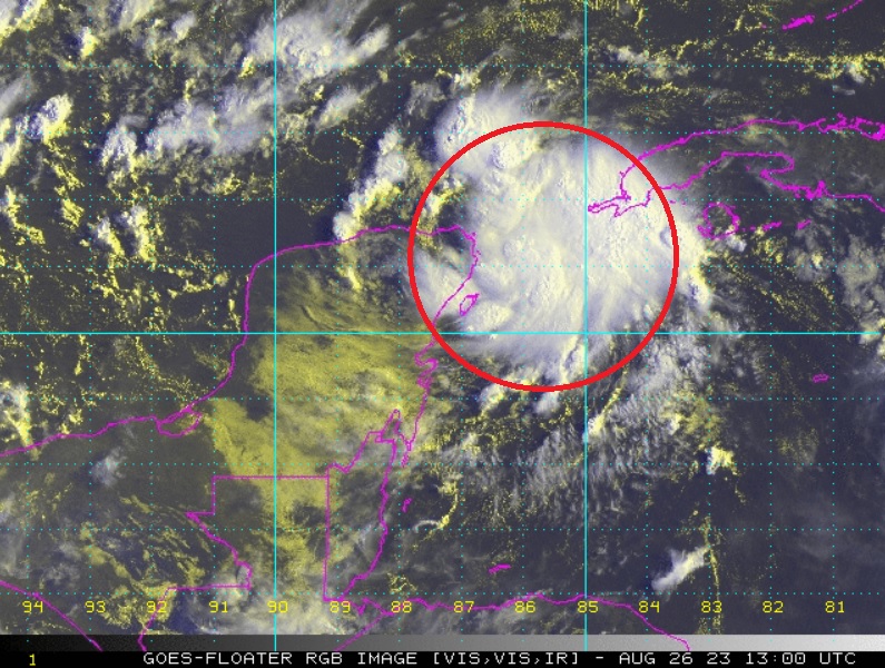
First light helps confirm overnight ship and buoy reports that a small well-defined low-level vortext most likely exists under increasingly better-organized deep convection, and a tropical cyclone may already exist or presently be forming, somewhere about 21N 86W as of 26/1300z in the image above.
Smaller T.C.s can be especially challenging for models to identify and forecast, and at this point I would take any models that call for a weaker tropical cyclone in the Gulf with a grain of salt. With the especially favorable SSTs, things could ramp up quite a bit more.
Unfortunately for all, scatterometer has missed 93L for almost 24 hours, and recon won't be out until tomorrow.
There is possibly already a small core of winds to tropical storm force in the system.
|
cieldumort
Moderator
Reged:
Posts: 2517
Loc: Austin, Tx
|
|
#93L (Idalia-to-be if you will) is drifting about over deeply very warm waters in a steering current collapse left in Franklin's wake, and it may not be until about late Monday or Tuesday before a High in between the two becomes established enough to get 93L moving towards the coast in a meaningful way.
Idalia-to-be has an unpleasantly large window to intensify over exceptionally warm SSTs and in an environment of lower to low shear. The potential for this cyclone to Major is arguably well above average.
Here is my initial best guess lifetime Maximum Sustained Winds for Invest 93L (Future Idalia)
<35 KTS 1%
35-45 KTS 4%
50 KTS - 60 KTS 10%
Cat 1 15%
Cat 2 18%
Cat 3 22%
Cat 4 22%
Cat 5 8%
A little less confidence as usual for when I attempt to roll these out, entirely because as of now we have had no recon, and very sparse scatterometer data.
Looked at another way, I assign an 85% chance that 93L becomes a hurricane at some point - and a better than 50% chance that 93L Majors.
Interests from northern Yucatan to western Cuba to South Florida to Alabama could be at risk, as the future steering pattern is far from well understood. Having recon is ASAP will be a great benefit.
|
OrlandoDan
Weather Master
Reged:
Posts: 456
Loc: Longwood, FL
|
|
Very good agreement between and Euro. The smallest difference will make a huge difference in the landfall given the relative positions of the panhandle and the storm. All interests on the Gulf Coast of Florida should be cautious. Obviously the Panhandle and Big Bend areas should be especially diligent.
--------------------
Keith (1988), Charley (2004), Frances (2004) , Jeanne (2004), Fay (2008), Mathew (2016), Irma (2017), Dorian (2019)
Personal Weather Station: https://www.wunderground.com/dashboard/pws/KFLLONGW67
|
vineyardsaker
Weather Guru

Reged:
Posts: 154
Loc: New Smyrna Beach, FL
|
|
Post deleted by vineyardsaker
--------------------
Charley(eyewall), Ivan, Jeanne, Dennis, Wilma, Irma, Ian (eyewall), Nicole, Helene, Milton
|
MikeC
Admin
Reged:
Posts: 4671
Loc: Orlando, FL
|
|
18z landfall near St. Marks Midday Wednesday Cat 2
18z Icon Landfall Wednesday morning near Tampa, Tropical Storm
12z Euro Cat 1 Landfall Near Steinhatchee Wednesday Afternoon
18z HAFSA- Landfall Near Crystal River cat 3 Hurricane Early Wednesday Morning (Rakes surge along Tampa North to Crystal River)
18z HAFSB - Landfall Near Cedar Key, Cat 2/3 Hurricane Wednesday morning
18z HMON Lnadfall Near Mexico Beach Cat 3 Hurricane Wednesday morning
|
MikeC
Admin
Reged:
Posts: 4671
Loc: Orlando, FL
|
|
Not enough time for models, but with recon reports today there's a decent chance the track will shift further right (East/south) at 5pm. The 12Z models did not have any recon data in them.
|
OrlandoDan
Weather Master
Reged:
Posts: 456
Loc: Longwood, FL
|
|
Mike, just curious why you are forecasting a shift right?
--------------------
Keith (1988), Charley (2004), Frances (2004) , Jeanne (2004), Fay (2008), Mathew (2016), Irma (2017), Dorian (2019)
Personal Weather Station: https://www.wunderground.com/dashboard/pws/KFLLONGW67
|
MikeC
Admin
Reged:
Posts: 4671
Loc: Orlando, FL
|
|
Mainly comparing inital positions of the 12Z models to the recon vortex messages. Recon was ese about 50-60 miles. So I'd expect a slight shift right at 18Z. Likely still north of tampa toward the big bend, though. Still I wouldn't gamble with not doing preparations along the west coast. Impacts could be larger than the cone to the right of landfall.
|
cieldumort
Moderator
Reged:
Posts: 2517
Loc: Austin, Tx
|
|
There looks to be a few reasons why rightward adjustments to the forecast track may be coming.
In general, there has been more of a blowup of convection downshear from the center and this is likely to continue off and on. What has occurred most recently isn't as much as a center jump per se, than more likely a cyclonic loop responding to the changing steering currents. But going forward, given the lopsided convection at present and forecasts of some on again off again modest northwesterly shear, one could expect a better chance of either center reformations or just simply adjustments downshear (to the east). All that said, a better chance is not saying such an outcome is certain. In addition, that northerly/northwesterly shear may be less than expected.
At this point, I'm all but ignoring 12Z model runs myself (at least as far as Idalia is concerned). I want to see both the 18Z and 0z runs before biting on anything.
|
cieldumort
Moderator
Reged:
Posts: 2517
Loc: Austin, Tx
|
|
After ingesting this morning's recon data, 18Z runs are trending more towards a landfall in the Big Bend area, not less. This should yet be taken with caution. Idalia is still in early development stages, and models often do not handle the tugs and jumps associated with lopsided convection as well as one would like.
|


 Threaded


