OrlandoDan
Weather Master

Reged:
Posts: 443
Loc: Longwood, FL
|
|
Appreciate the reply, Mike.
I expect some diffluent upper-level flow to the east of
the trough and this will likely be conducive for strengthening.
--------------------
Keith (1988), Charley (2004), Frances (2004) , Jeanne (2004), Fay (2008), Mathew (2016), Irma (2017), Dorian (2019)
Personal Weather Station: https://www.wunderground.com/dashboard/pws/KFLLONGW67
|
cieldumort
Moderator

Reged:
Posts: 2305
Loc: Austin, Tx
|
|

As the sun begins going down over Franklin, from a wide view, it becomes easy to appreciate how much larger Idalia is becoming.
The tropical cyclone inner vortex was always small, but wrapped up a bit inside a larger monsoonal depression that crossed over Central America. It now appears that the southward realignment as the result of northwesterly shear working with what was probably otherwise a routine attempt at a loop, has re-coupled the T.C's tight vortex more with its parent monsoonal low. This could have significant implications for the size of Idalia's wind field, amount and duration of heavy precipitation (with attendant flooding), as well as its future track.
It will be informative to see if 0z runs initiate or quickly catch up to the more bloated cyclone.
|
MichaelA
Weather Analyst

Reged:
Posts: 944
Loc: Pinellas Park, FL
|
|
My wife and I left Pinellas Park on Thursday morning on our annual trek to northern NY through September. My daughter remains home and has completed her storm preparations. I’ll be monitoring things from afar and watching data from my PWS. Hopefully, Tampa Bay will luck out again.
--------------------
Michael
PWS
|
Prospero
Storm Tracker

Reged:
Posts: 267
Loc: Gulfport, FL
|
|
Quote:
My wife and I left Pinellas Park on Thursday morning on our annual trek to northern NY through September. My daughter remains home and has completed her storm preparations. I’ll be monitoring things from afar and watching data from my PWS. Hopefully, Tampa Bay will luck out again.
We restocked our batteries and will replace the old ones in our flashlights. We'll make sure our CPap battery backups are charged.
Duke Energy has replaced most of the power poles in our area (Gulfport, FL) so hopefully we are not the first to lose power during the storm like usual. In the past as soon as we get a stiff breeze the power would go out. UGH
--------------------
Gulfport Florida Webcam - Gulfport Florida Weather Station - Clearwater Beach Cams
|
cieldumort
Moderator
Reged:
Posts: 2305
Loc: Austin, Tx
|
|
Some visual aids as to how Idalia might look during the middle of the night Tuesday (06z or 07z on the 30th), based on 8/27/18z runs of these respective models
Simulated IR model runs:
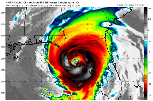
HWRF
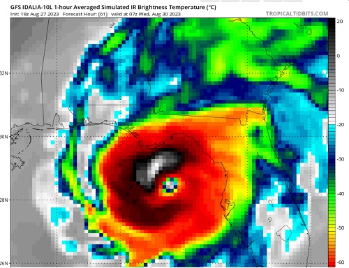
GFS
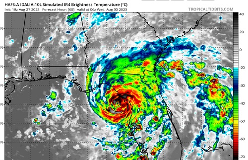
HAFS-A
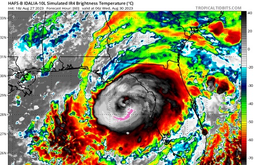
HAFS-B
|
cieldumort
Moderator
Reged:
Posts: 2305
Loc: Austin, Tx
|
|
Here are my updated best guesses as to Idalia's peak lifetime maximum wind speed. I should add that this is also most likely to occur prior to crossing Florida, and possibly right into landfall.
<35 KTS 0% (Has exceeded)
35-45 KTS 0% (Has exceeded)
50 KTS - 60 KTS 2% (Current wind speeds estimated by )
Cat 1 4%
Cat 2 17%
Cat 3 24%
Cat 4 31%
Cat 5 22%
Or looked at another way, I now give a 94% chance that Idalia becomes a hurricane, a 77% chance that Idalia becomes a Major, a 53% chance that Idalia becomes a high-end Major, and a 22% chance that Idalia becomes a Category 5.
There are still several things that could go wrong for Idalia and prevent it from becoming a Major hurricane, but there are also more things that seem to be setting up "right" (for higher-end hurricane).
|
cieldumort
Moderator
Reged:
Posts: 2305
Loc: Austin, Tx
|
|
28/0z model runs ingested quite a bit of Hurricane Hunter data and as such are of greater interest
Vortex-scale hurricane models
0z HWRF - Initialized a touch too far northwest, but not horribly. Majors overnight Tuesday, becoming Cat 4 heading into landfall (in fact, 850hPa wind suggests a potential for gusts exceeding 150 KTS predawn Wednesday). Landfall as a Cat 3+ in vicinity of Redfish Point, Apalachee Bay Wednesday morning.
0z HMON - Also initialized a touch too far northeast, but not horribly. Majors Tuesday morning. High-end Cat 2 heading towards landfall overnight Tuesday. Landfalls in vicinity between Steinhatchee and Fish Creek early Wednesday morning probably about Cat 2.
0z HAFS-A Solid inititial location. Majors heading into landfall predawn Wednesday, with an apparent landfall location somewhere between Horseshoe Beach and Steinhatchee as a Major early Wednesday morning.
0z HAFS-B Solid initial location. Majors Tuesday evening. Cat 4s Tuesday overnight. Landfalls roughly southeast of St Marks in the Apalachee Bay Wednesday morning, seemingly Cat 2/3.
|
bob3d
Weather Watcher

Reged:
Posts: 39
Loc: Pasco County, Florida
|
|
With the vast majority of the models showing a Big Bend landfall with each update, and the cone of uncertainty is getting more and more precise, I noticed it is always showing Tampa Bay in its right-most sector of the cone. Since I live just north of Tampa, this is getting more and more concerning to me as the forecast storm strength increases with each model run.
|
IsoFlame
Weather Analyst

Reged:
Posts: 295
Loc: One block off the Atlantic Oce...
|
|
When Idalia has increasing structure/organization (as forecast) over the exceptionally warm eastern GOMEX Tuesday/early Wednesday in a very favorable environment for rapid intensification, Cat 4 may be within reach especially if the forward speed stays around 10 mph and the inner core stands off the Fla west coast until landfall north of St.Pete/Clearwater (given Franklin's impressive 11am stats on the other side of the peninsula: 145 mph / 937mb)
--------------------
CoCoRaHS Weather Observer (FL-VL-42) & Surf Forecaster: https://www.surf-station.com/north-florida-surf-forecast-3/
|
IsoFlame
Weather Analyst
Reged:
Posts: 295
Loc: One block off the Atlantic Oce...
|
|
Recon coming in today ahead of Idalia's intensification will refine the forecast.

What will be very problematic for predicting the greatest impact Idalia will have on Florida's west coast will be the propensity for TC's tracking north in the eastern GOMEX (parallel to the Fla peninsula) to "right turn Clyde" on the south side of modeling.
--------------------
CoCoRaHS Weather Observer (FL-VL-42) & Surf Forecaster: https://www.surf-station.com/north-florida-surf-forecast-3/
|
Prospero
Storm Tracker
Reged:
Posts: 267
Loc: Gulfport, FL
|
|
Quote:
...
What will be very problematic for predicting the greatest impact Idalia will have on Florida's west coast will be the propensity for TC's tracking north in the eastern GOMEX (parallel to the Fla peninsula) to "right turn Clyde" on the south side of modeling.
Our home in Gulfport FL was in the center of the cone on the mornings of Irma and Ian if I remember correctly. Both storms left the cones and shifted East. I think right now I'd feel much more relaxed if Tampa Bay was in the center of the cone. But if I lived in Sarasota I'd be nervous.
--------------------
Gulfport Florida Webcam - Gulfport Florida Weather Station - Clearwater Beach Cams
|
IsoFlame
Weather Analyst
Reged:
Posts: 295
Loc: One block off the Atlantic Oce...
|
|
Very Impressive : Idalia deep convection
Rapid intensification soon to follow.
--------------------
CoCoRaHS Weather Observer (FL-VL-42) & Surf Forecaster: https://www.surf-station.com/north-florida-surf-forecast-3/
|
cieldumort
Moderator
Reged:
Posts: 2305
Loc: Austin, Tx
|
|
Idalia conditions in your area
|
Rick31416
Registered User
Reged:
Posts: 3
|
|
Sure seems to me it's lost it's shear, fanning out in that direction, and formed something of an eye. And it's racing north.
Not that I have a clue, other than being in a dozen hurricanes, and watching the pretty pictures.
https://www.tropicaltidbits.com/sat/satlooper.php?region=10L&product=ir
|
cieldumort
Moderator
Reged:
Posts: 2305
Loc: Austin, Tx
|
|
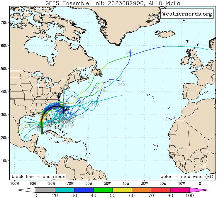
The 29/0z ensembles are out and if you like heartburn or were a fan of ....
|
OrlandoDan
Weather Master
Reged:
Posts: 443
Loc: Longwood, FL
|
|
Saw on WESH 2 news in Orlando that she may have taken a slight jog right. What impacts this have if it continues?
--------------------
Keith (1988), Charley (2004), Frances (2004) , Jeanne (2004), Fay (2008), Mathew (2016), Irma (2017), Dorian (2019)
Personal Weather Station: https://www.wunderground.com/dashboard/pws/KFLLONGW67
|
JMII
Weather Master

Reged:
Posts: 489
Loc: Margate, Florida
|
|
Quote:
The 29/0z ensembles are out and if you like heartburn or were a fan of ....
A loop back is super rare... but given the right conditions anything is possible.
Idalia is behaving as predicted: starting to wrap up, entering a low shear/high heat environment, all signs that a Cat 3/major status should occur. In the water vapor satellite loops you can see the weather pattern over LA/TX that will curve her east.
--------------------
South FL Native... experienced many tropical systems, put up the panels for:
David 79 - Floyd 87 - Andrew 92 - Georges 98 - Frances 04 - Wilma 05 - Matthew 16 - Irma 17
Lost our St James City rental property to Ian 22
|
IsoFlame
Weather Analyst
Reged:
Posts: 295
Loc: One block off the Atlantic Oce...
|
|
Until we have a visible eye, follow Idalia's progress on radar
--------------------
CoCoRaHS Weather Observer (FL-VL-42) & Surf Forecaster: https://www.surf-station.com/north-florida-surf-forecast-3/
|
cieldumort
Moderator
Reged:
Posts: 2305
Loc: Austin, Tx
|
|
Quote:
Saw on WESH 2 news in Orlando that she may have taken a slight jog right. What impacts this have if it continues?
I noticed something like that from back when Idalia was tracking just west of Cuba, but the "jog right," if that is indeed what it was, isn't a big one, and in fact, the most recent recon pass through the cyclone just had a slight hook left.
Track has been more or less due north overall. I suspect that looking at its movement as smoothed over three to six hours, as does, is still going to be most informative in the longer-term. Temporary wobbles and jogs as Idalia is approaching the coast would have some greater immediate significance to those in her path of course.
|
IsoFlame
Weather Analyst
Reged:
Posts: 295
Loc: One block off the Atlantic Oce...
|
|
My son lives in St. Pete (on high ground) and my 90-yr old dad lives in Brunswick, GA. After Idalia landfalls in/near the Big Bend, I expect that my dad will have higher winds (with minimal surge) if Idalia "right hooks" and tracks through SE GA as a Cat 1 or strong TS.
--------------------
CoCoRaHS Weather Observer (FL-VL-42) & Surf Forecaster: https://www.surf-station.com/north-florida-surf-forecast-3/
|


 Threaded


