cieldumort
Moderator

Reged:
Posts: 2341
Loc: Austin, Tx
|
|
As the features that tend to "lock in" a season's character become more evident as time progresses, many professional agencies update their preseason forecasts in June all the way through even October. In this thread we will highlight preseason forecasts and their updates, post updates to known predictors as they come in, and add any of our own thoughts.
This is an open thread to registered members with relevant information and opinions (backed up with reasoning please) to post.
|
cieldumort
Moderator
Reged:
Posts: 2341
Loc: Austin, Tx
|
|
Credit to: SeasonalHurricanePredictions.org.
Quote:
The Seasonal Hurricane Predictions platform provides free access to seasonal forecasts issued by a number of universities, private sector entities and government agencies around the world for the upcoming hurricane season in the North Atlantic.
The platform allows forecasters to make these predictions freely available to the wider public, compare the predictions with real-time hurricane activity, and obtain the best estimate of upcoming hurricane activity.
This platform has been co-developed by the Barcelona Supercomputing Center (BSC) and the Colorado State University (CSU), with support from the global (re)insurer AXA XL.
The following represent 2024 Season Forecasts issued through early June.
Named Storms

Hurricanes
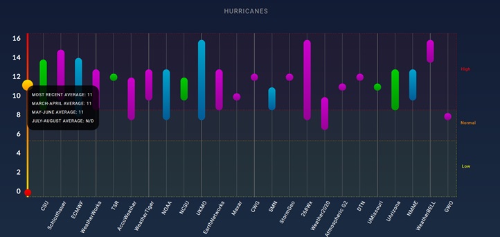
Major Hurricanes

|
cieldumort
Moderator
Reged:
Posts: 2341
Loc: Austin, Tx
|
|
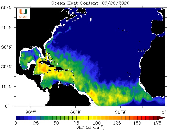
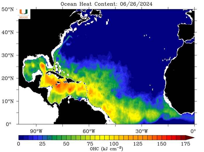
Now that we are closing out the final week of the first month of the 2024 Atlantic Hurricane Season, here is a comparison of the Ocean Heat Content (OHC) for yesterday, June 26 2024, with June 26, 2020.
2020 was the most active Atlantic season on record in terms of total systems with 31 Depressions (Tied with 2005 for most), 30 Storms (Record high), 14 Hurricanes and 7 Majors (Tied with 2005 for most for Majors).
It is important to note that SSTs alone do not dictate the stats for a hurricane season, but high SSTs do strongly support hyperactive years.
OHC maps credit: University of Miami Rosenstiel School of Marine, Atmospheric, and Earth Science
|
cieldumort
Moderator
Reged:
Posts: 2341
Loc: Austin, Tx
|
|
Most years, preseason and early season tropical cyclone activity does not portend an active season over all. However, as Dr. Philip Klotzbach @PhilKlotzbach points out, the years when we have early activity out in the Tropical Atlantic do, with a notable exception of 2013.
Recently Dr. Klotzbach recently added, "7 years on record (since 1851) have had named storm formation in tropical Atlantic (S of 20°N, E of 60°W) by 4 July: 1901, 1933, 1979, 2008, 2017, 2021, 2023."
Meanwhile, Dr. Tomer Burg @burgwx notes, "Caribbean hurricanes aren't uncommon - but they are far less common this time of year in the deep tropics. Only 4 category 2+ hurricanes are known to have tracked through this corridor before July 10th"
Newly named Tropical Storm Beryl is explicitly forecast to become a Category 2 Hurricane tracking through this corridor, and actually well before July 10th. This would put 2024's Beryl in the company of the following other names and years: Bertha (2008), (2005), Bertha (1996) and lastly "Unnamed" from 1933.
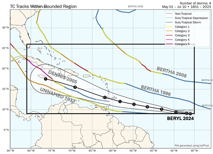
Image credit: Tomer Burg @burgwx
Here are the official season stats for the above identified years. Next to each season I also note if the state was (El Niño, Neutral or La Niña). This matters, as generally El Niño tends to suppress activity in the Atlantic basin, whereas Neutral s and La Niña years often enhance it.
Disclaimer: It is important to note that additional tropical cyclones were possibly missed before the satellite era, so official counts prior to 1966 may not reflect actual totals.
1901 (ENSO Neutral): 13 Storms, 6 Hurs, 0 Majors
1933 (ENSO Neutral): 20 Storms, 11 Hurs, 6 Majors
1979 (ENSO Neutral to Weak El Niño): 9 Storms, 6 Hurs, 2 Majors
1996 (ENSO Neutral): 13 Storms, 9 Hurs, 6 Majors
2005 (ENSO Neutral): 28 Storms, 15 Hurs, 7 Majors
2008 (ENSO Neutral to Weak La Niña): 16 Storms, 8 Hurs, 5 Majors
2017 (ENSO Neutral to Weak La Niña): 17 Storms, 10 Hurs, 6 Majors
2021 (ENSO La Niña): 21 Storms, 7 Hurs, 4 Majors
2023 (ENSO Moderate to Strong El Niño): 20 Storms, 7 Hurs, 3 Majors
Last year is the only outright Niño year on the list, and a fairly strong one at that. It appears that the Atlantic still went gangbusters because SSTs were record warm, overcoming the background state.
The current state of in 2024 is Neutral with a forecast to trend into a La Niña later this year.
|
cieldumort
Moderator
Reged:
Posts: 2341
Loc: Austin, Tx
|
|
Something else to consider when comparing 2024 to prior years and looking for best analogs...
As of the June 29, 2024 11AM Advisory, the updated intensity forecast explicitly forecasts Rapid Intensification and brings Beryl up to Major (Cat 3+) before it even reaches the Windwards. For the time of year, this is unprecedented.
Just looking at hurricanes passing within 100 miles of Barbados this early in a season, Dr. Philip Klotzbach notes: "Only 2 hurricanes on record (since 1851) have been within 100 miles of Barbados prior to 1 August: Emily (2005) and Elsa (2021)"
Taking a look at the intensities and tracks of our two only analogs for this event:
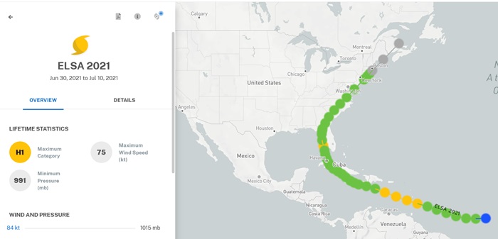
Above: Elsa (2021) passed through the Windwards as a Cat 1
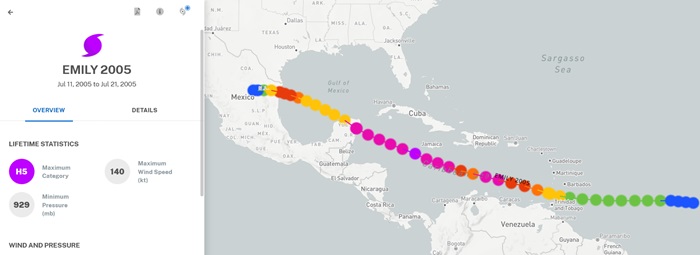
Above: Emily (2005) passed through the Windwards as a Cat 1
|
|


 Threaded


