cieldumort
Moderator

Reged:
Posts: 2520
Loc: Austin, Tx
|
|
As the features that tend to "lock in" a season's character become more evident as time progresses, many professional agencies update their preseason forecasts in June all the way through even October. In this thread we will highlight preseason forecasts and their updates, post updates to known predictors as they come in, and add any of our own thoughts.
This is an open thread to registered members with relevant information and opinions (backed up with reasoning please) to post.
|
cieldumort
Moderator

Reged:
Posts: 2520
Loc: Austin, Tx
|
|
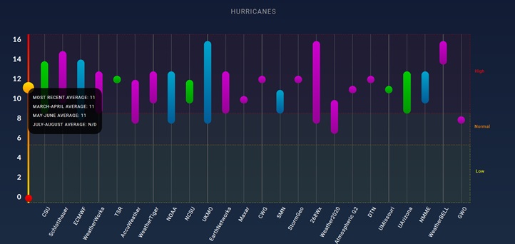
Credit to: SeasonalHurricanePredictions.org.
Quote:
The Seasonal Hurricane Predictions platform provides free access to seasonal forecasts issued by a number of universities, private sector entities and government agencies around the world for the upcoming hurricane season in the North Atlantic.
The platform allows forecasters to make these predictions freely available to the wider public, compare the predictions with real-time hurricane activity, and obtain the best estimate of upcoming hurricane activity.
This platform has been co-developed by the Barcelona Supercomputing Center (BSC) and the Colorado State University (CSU), with support from the global (re)insurer AXA XL.
The following represent 2024 Season Forecasts issued through early June.
Named Storms

Hurricanes

Major Hurricanes

|
cieldumort
Moderator

Reged:
Posts: 2520
Loc: Austin, Tx
|
|
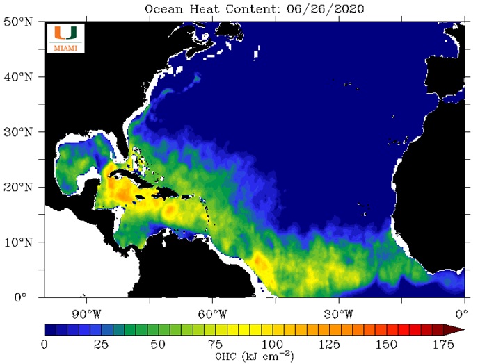
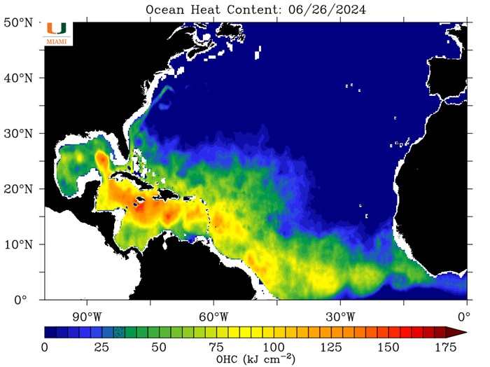
Now that we are closing out the final week of the first month of the 2024 Atlantic Hurricane Season, here is a comparison of the Ocean Heat Content (OHC) for yesterday, June 26 2024, with June 26, 2020.
2020 was the most active Atlantic season on record in terms of total systems with 31 Depressions (Tied with 2005 for most), 30 Storms (Record high), 14 Hurricanes and 7 Majors (Tied with 2005 for most for Majors).
It is important to note that SSTs alone do not dictate the stats for a hurricane season, but high SSTs do strongly support hyperactive years.
OHC maps credit: University of Miami Rosenstiel School of Marine, Atmospheric, and Earth Science


|
cieldumort
Moderator

Reged:
Posts: 2520
Loc: Austin, Tx
|
|
Most years, preseason and early season tropical cyclone activity does not portend an active season over all. However, as Dr. Philip Klotzbach @PhilKlotzbach points out, the years when we have early activity out in the Tropical Atlantic do, with a notable exception of 2013.
Recently Dr. Klotzbach recently added, "7 years on record (since 1851) have had named storm formation in tropical Atlantic (S of 20°N, E of 60°W) by 4 July: 1901, 1933, 1979, 2008, 2017, 2021, 2023."
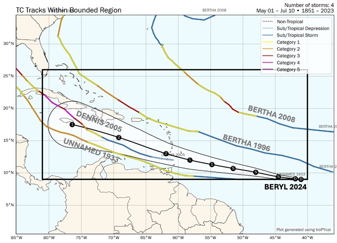
Meanwhile, Dr. Tomer Burg @burgwx notes, "Caribbean hurricanes aren't uncommon - but they are far less common this time of year in the deep tropics. Only 4 category 2+ hurricanes are known to have tracked through this corridor before July 10th"
Newly named Tropical Storm Beryl is explicitly forecast to become a Category 2 Hurricane tracking through this corridor, and actually well before July 10th. This would put 2024's Beryl in the company of the following other names and years: Bertha (2008), (2005), Bertha (1996) and lastly "Unnamed" from 1933.

Image credit: Tomer Burg @burgwx
Here are the official season stats for the above identified years. Next to each season I also note if the state was (El Niño, Neutral or La Niña). This matters, as generally El Niño tends to suppress activity in the Atlantic basin, whereas Neutral s and La Niña years often enhance it.
Disclaimer: It is important to note that additional tropical cyclones were possibly missed before the satellite era, so official counts prior to 1966 may not reflect actual totals.
1901 (ENSO Neutral): 13 Storms, 6 Hurs, 0 Majors
1933 (ENSO Neutral): 20 Storms, 11 Hurs, 6 Majors
1979 (ENSO Neutral to Weak El Niño): 9 Storms, 6 Hurs, 2 Majors
1996 (ENSO Neutral): 13 Storms, 9 Hurs, 6 Majors
2005 (ENSO Neutral): 28 Storms, 15 Hurs, 7 Majors
2008 (ENSO Neutral to Weak La Niña): 16 Storms, 8 Hurs, 5 Majors
2017 (ENSO Neutral to Weak La Niña): 17 Storms, 10 Hurs, 6 Majors
2021 (ENSO La Niña): 21 Storms, 7 Hurs, 4 Majors
2023 (ENSO Moderate to Strong El Niño): 20 Storms, 7 Hurs, 3 Majors
Last year is the only outright Niño year on the list, and a fairly strong one at that. It appears that the Atlantic still went gangbusters because SSTs were record warm, overcoming the background state.
The current state of in 2024 is Neutral with a forecast to trend into a La Niña later this year.
|
cieldumort
Moderator

Reged:
Posts: 2520
Loc: Austin, Tx
|
|
Something else to consider when comparing 2024 to prior years and looking for best analogs...
As of the June 29, 2024 11AM Advisory, the updated intensity forecast explicitly forecasts Rapid Intensification and brings Beryl up to Major (Cat 3+) before it even reaches the Windwards. For the time of year, this is unprecedented.
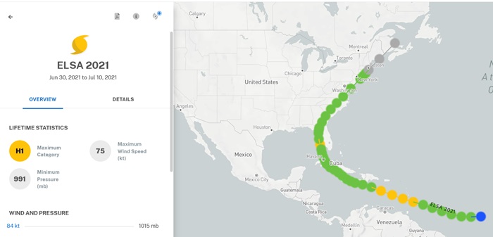
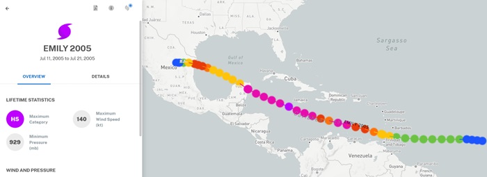
Just looking at hurricanes passing within 100 miles of Barbados this early in a season, Dr. Philip Klotzbach notes: "Only 2 hurricanes on record (since 1851) have been within 100 miles of Barbados prior to 1 August: Emily (2005) and Elsa (2021)"
Taking a look at the intensities and tracks of our two only analogs for this event:

Above: Elsa (2021) passed through the Windwards as a Cat 1

Above: Emily (2005) passed through the Windwards as a Cat 1
|
cieldumort
Moderator

Reged:
Posts: 2520
Loc: Austin, Tx
|
|
Colorado State released their 2024 Atlantic Hurricane Season updated forecast today and unsurprisingly the numbers went up a bit from an already busy season being forecast
|
cieldumort
Moderator

Reged:
Posts: 2520
Loc: Austin, Tx
|
|
There have been some updates to professional seasonal forecasts the past few days.
After starting off with a bang, the 2024 Atlantic Hurricane Season has been riddled with record high dry dusty air (SAL) over the Main Development Region that has only recently begun coming back down to more normal levels. Strong high pressure across the Atlantic has also resulted in some rather fast forward speeds of would-be tropical cyclones. Additionally, the expected La Niña has so far failed to develop, with more of a "cool neutral" state in place instead, and on Thursday the Climate Prediction Center shifted their forecast La Niña start date from originally July to September, to now September to October. Finally, with things not coming into place as expected across the Atlantic, the East Pac has recently turned hot, with outflow from multiple clusters of thunderstorms and tropical cyclones increasing shear that bleeds across into the Atlantic side of central America, further suppressing development there.
Given these factors, my own best guess has gone from my preseason range of 24-36 Depressions, 22-34 Storms, 10-16 Hurricanes and 4-8 Majors, with a season ACE of 204 ± 40, and a specific best guess of 26 Storms 13 Hurricanes and 5 Majors, to 20-28 Storms, 11-14 Hurricanes and 5-8 Majors, with a season ACE of 225 ± 50, and a specific best guess of 24 Storms, 12 Hurricanes and 7 Majors. A few less names, a few more become Majors and better odds of longer tracking cyclones as the season progresses. My updated guesses have no bearing on our community contest.
As of today, August 12, climatologically speaking, 87% of an Atlantic hurricane season still lies ahead.
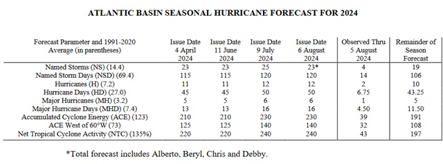
Colorado State released their most recent update on August 6 (Image below)

Colorado State August 6 Forecast
|
IsoFlame
Weather Analyst

Reged:
Posts: 381
Loc: One block off the Atlantic Oce...
|
|
Even though this season is running a bit ahead on named storms, hurricanes and the phenomenally early monster Beryl, given the chance I'd par back my pre-season forecast from: 23-10-4 to a more normal 18-8-3 based on my gut telling me the unusual mid-August "cold" front that just pushed most of the way down the Florida peninsula today may be a pre-cursor of an early onset of late summer/early fall frontal activity this season. Add to that a general leveling off in August from the crazy warm SST's in that we've seen throughout the Atlantic basin this year, I don't think the second half of August and possibly September will see historically high numbers. We shall see...
--------------------
CoCoRaHS Weather Observer (FL-VL-42) & Surf Forecaster: https://www.surf-station.com/north-florida-surf-forecast-3/
|
IsoFlame
Weather Analyst

Reged:
Posts: 381
Loc: One block off the Atlantic Oce...
|
|
At the tail end of the last several runs, suggests a strong tropical wave tracking WNW into either the NW Carribean Sea or SW Atlantic may develop in early September on or shortly after Labor Day.
--------------------
CoCoRaHS Weather Observer (FL-VL-42) & Surf Forecaster: https://www.surf-station.com/north-florida-surf-forecast-3/
|
IsoFlame
Weather Analyst

Reged:
Posts: 381
Loc: One block off the Atlantic Oce...
|
|
12Z run now suggests a strong TC in the northeastern GOMEX around or shortly after the climo Sept 10th peak of activity:
Sept 11th 12Z
--------------------
CoCoRaHS Weather Observer (FL-VL-42) & Surf Forecaster: https://www.surf-station.com/north-florida-surf-forecast-3/
|
cieldumort
Moderator

Reged:
Posts: 2520
Loc: Austin, Tx
|
|
Back on May 31st, the day before the official start of the Atlantic Hurricane Season of 2024, I posted to our community contest the following Quote:
My read of the preseason predictors suggests roughly 75% odds of an above-average to record-setting season this year, about a one-in-five chance of an average season, and a very low but non-zero chance of a below-average season. I think the factor that could most impede or even prevent a very active season is the Saharan Air Layer (SAL), which is notoriously hard to predict this early but that doesn't seem particularly in play, at least not yet.
The caveat was not looking for a preemptive excuse in case of a bad call, although it certainly helps in that regard, but my reasoning that my own forecast could bust. At that time for the purpose of our annual contest, I best guessed "26 Storms 13 Hurricanes 5 Majors," but it was already apparent that there would be a risk of a dry, dusty season, or for at least part of the season. Nonetheless, the information available to me at the time as well as all others, including the pros, rolled out a forecast of a hyperactive hurricane season, with some agencies putting out mind-boggling totals not far from my own.
Well, Captain Obvious has some thoughts about this

The darn thing is, even though the Atlantic is rip-roaring hot relative to average, and the eastern Pacific is in a "cool neutral" state relative to average, once a pattern sets up that shuts one basin off can quickly conspire to enhance another, regardless of background state. I believe we have been witnessing this in 2024 ever since the rapid ramp-up in June collapsed.
Indeed, as was my preseason caveat, an active Saharan Air Layer (SAL ~ Saharan dry and dusty air), looks to be culprit #1. In fact, SAL this year has been swinging wildly between well below average earlier in the year, to more recently, during July and August, even record-setting high. Tropical cyclones do not like dry, dusty air. At all.
And often working in tandem with this SAL has been an setup that is further north than ideal, sending would-be TC seedling waves immediately into hostile SAL territory, even also over anomalously cooler SSTs just off the coast of Africa closer to and around the Canary Islands. Much too far north to worry those west of the 55th Meridian West under most circumstances.
Yet another feature that has served to choke would-be Atlantic TCs the past two months has been too much of a good thing. Strong high pressure across the North Atlantic that had been expected to moderate westerly shear, has actually resulted in easterly shear.
And to come full circle, waves that somehow traveled west at a more southerly latitude have usually been held in check and forced to cross over into the East Pac, where they still found very warm waters, despite the lack of El Niño. And often when thunderstorms and hurricanes are active in the East Pac, shear gets higher still over the Western Atlantic.
Those of us watching for systems in the Atlantic...

Some years, as recently as 2022 for example, the seasonality of SAL and other inhibiting factors that choked much of the activity July through August gave up the ghost, leading to a very busy rest of the season starting in September, and this is very plausible. I have some reservations, but think the odds of this happening here are closer to 60/40 in favor.
Given all of this, my updated update (for funzies only! seasonal forecasting is not my thing, but I enjoy trying)
Prior update: 20-28 Storms, 11-14 Hurricanes and 5-8 Majors, with a season ACE of 225 ± 50, and a specific best guess of 24 Storms, 12 Hurricanes and 7 Majors
My August 26 update: 15-20 Storms, 7-10 Hurricanes, 4-7 Majors, with a season ACE of 170 ± 40. Best specific guess of 17 Storms, 9 Hurricanes, 5 Majors. This includes the systems we have had so far which have been 5 Names (Alberto, Beryl, Chris, Debby and ), of which 3 have become Hurricanes (Beryl, Debby and ), of which 1 Majored (Beryl).
|
IsoFlame
Weather Analyst

Reged:
Posts: 381
Loc: One block off the Atlantic Oce...
|
|
Quote:
Back on May 31st, the day before the official start of the Atlantic Hurricane Season of 2024, I posted to our community contest the following Quote:
My read of the preseason predictors suggests roughly 75% odds of an above-average to record-setting season this year, about a one-in-five chance of an average season, and a very low but non-zero chance of a below-average season. I think the factor that could most impede or even prevent a very active season is the Saharan Air Layer (SAL), which is notoriously hard to predict this early but that doesn't seem particularly in play, at least not yet.
The caveat was not looking for a preemptive excuse in case of a bad call, although it certainly helps in that regard, but my reasoning that my own forecast could bust. At that time for the purpose of our annual contest, I best guessed "26 Storms 13 Hurricanes 5 Majors," but it was already apparent that there would be a risk of a dry, dusty season, or for at least part of the season. Nonetheless, the information available to me at the time as well as all others, including the pros, rolled out a forecast of a hyperactive hurricane season, with some agencies putting out mind-boggling totals not far from my own.
The darn thing is, even though the Atlantic is rip-roaring hot relative to average, and the eastern Pacific is in a "cool neutral" state relative to average, once a pattern sets up that shuts one basin off can quickly conspire to enhance another, regardless of background state. I believe we have been witnessing this in 2024 ever since the rapid ramp-up in June collapsed.
Indeed, as was my preseason caveat, an active Saharan Air Layer (SAL ~ Saharan dry and dusty air), looks to be culprit #1. In fact, SAL this year has been swinging wildly between well below average earlier in the year, to more recently, during July and August, even record-setting high. Tropical cyclones do not like dry, dusty air. At all.
And often working in tandem with this SAL has been an setup that is further north than ideal, sending would-be TC seedling waves immediately into hostile SAL territory, even also over anomalously cooler SSTs just off the coast of Africa closer to and around the Canary Islands. Much too far north to worry those west of the 55th Meridian West under most circumstances.
Yet another feature that has served to choke would-be Atlantic TCs the past two months has been too much of a good thing. Strong high pressure across the North Atlantic that had been expected to moderate westerly shear, has actually resulted in easterly shear.
And to come full circle, waves that somehow traveled west at a more southerly latitude have usually been held in check and forced to cross over into the East Pac, where they still found very warm waters, despite the lack of El Niño. And often when thunderstorms and hurricanes are active in the East Pac, shear gets higher still over the Western Atlantic.
Some years, as recently as 2022 for example, the seasonality of SAL and other inhibiting factors that choked much of the activity July through August gave up the ghost, leading to a very busy rest of the season starting in September, and this is very plausible. I have some reservations, but think the odds of this happening here are closer to 60/40 in favor.
It's complicated beyond my uneducated mind's comprehension. I go with gut feelings when I don't fully understand the underlying reasons. Me-gut is suggesting that anything that can make it to the GOMEX, Caribbean or Bahamas (TCs or early fronts) may potentially/explosively intensify.. I downgraded my call too, but still think that once things get going in September, October and early November may make up for the total lack of activity the last 3 weeks in August.
--------------------
CoCoRaHS Weather Observer (FL-VL-42) & Surf Forecaster: https://www.surf-station.com/north-florida-surf-forecast-3/
|
cieldumort
Moderator

Reged:
Posts: 2520
Loc: Austin, Tx
|
|
Looking ahead at the next couple of weeks, conditions for development and intensification basin-wide appear to be trending better than even during the climatological peak of the season of roughly Sep 1 - Sep 20.
One of the features largely responsible for tamping down development odds since early July has been ever-present high amounts of dry dust in the MDR and across much of the basin.This swung back down like a rock during the back half of August, but this favorable condition (for development) also coincided with other players, such as the placement of the , that created a lot of sinking air working to squash any wanna be TC from taking off.
That inhibiting combo looks to be changing now.
|
cieldumort
Moderator

Reged:
Posts: 2520
Loc: Austin, Tx
|
|
The heavily back-loaded season continues and continues breaking records. Even set just three days prior.
|
cieldumort
Moderator

Reged:
Posts: 2520
Loc: Austin, Tx
|
|
|
cieldumort
Moderator

Reged:
Posts: 2520
Loc: Austin, Tx
|
|
|
cieldumort
Moderator

Reged:
Posts: 2520
Loc: Austin, Tx
|
|
|
cieldumort
Moderator

Reged:
Posts: 2520
Loc: Austin, Tx
|
|
|
cieldumort
Moderator

Reged:
Posts: 2520
Loc: Austin, Tx
|
|
|
cieldumort
Moderator

Reged:
Posts: 2520
Loc: Austin, Tx
|
|
|
|


 Threaded


