cieldumort
Moderator

Reged:
Posts: 2497
Loc: Austin, Tx
|
|

An occasionally vigorous tropical wave in the Main Development Region is continuing to show signs of it holding together long enough and tracking poleward enough to potentially be of concern next week once in the Caribbean and per some models like the , especially so if/when it enters the Gulf.
While the background state for development out in the MDR is presently less than ideal, conditions are largely forecast to be increasingly hospitable in the central to western Caribbean and gulf all (potentially) along its path, and we are starting a lounge on this feature at this time.
This system is not yet Invest tagged and we will update the title as changes are made. More details to come soon.
This feature has gone on to help spin up 98E in the eastern Pacific which has a window to develop, and a small area of weak low pressure within remnant northern portions in the Bay of Campeche as of Aug 10, but TC genesis remains unlikely there. Ciel
Edited by cieldumort (Sat Aug 10 2024 05:27 PM)
|
cieldumort
Moderator

Reged:
Posts: 2497
Loc: Austin, Tx
|
|
In general, the probabilities for development in the Tropical Atlantic have been going up. For this particular wave, its chances look better once closer to or outright in the Caribbean.
The probabilities shown in the TCFPGP below also include the next wave coming up, but it does still advertise the improving conditions across the Tropical Atlantic overall.
Below:
Tropical Cyclone Formation Probability Guidance Product Developed by the Regional and Mesoscale Meteorology Branch at CIRA
0-48h TC Formation Probability

Below:
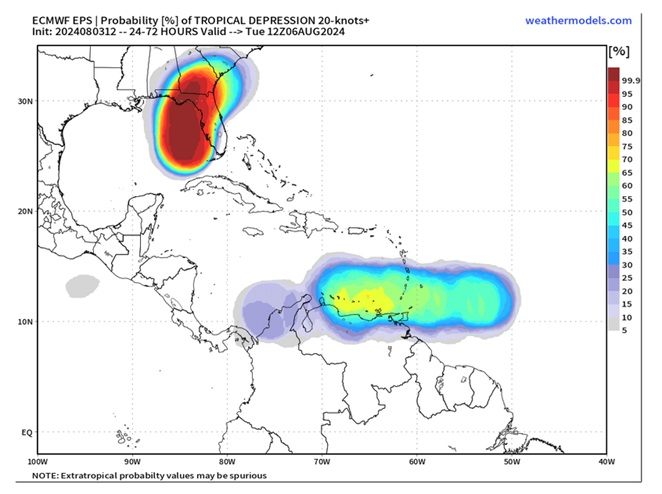
Today's 12Z ensembles-implied probabilities of development from this wave out 24-72 hours. As can be seen, these runs suggest its chances increase substantially once in the Caribbean.

|
cieldumort
Moderator

Reged:
Posts: 2497
Loc: Austin, Tx
|
|
If trends continue, this wave will probably be Invest tagged fairly soon.

Above: Area of Low pressure east of the southernmost Lesser Antilles that is associated with a tropical wave interacting with the monsoon trof at sunset.
|
cieldumort
Moderator

Reged:
Posts: 2497
Loc: Austin, Tx
|
|
Showers and thunderstorms associated with this feature have become a little less organized today, but modeling suggests conditions for development could improve mid-late week in the central to western Caribbean.
An overview of some of today's 12Z Global runs
ECMWF - Becomes a weak low in the southern Caribbean Wednesday Aug 8 and pushes into Central America later in the week, without development.
GFS - Becomes a weak low in the western Caribbean Thursday Aug 9 and tracks northwest, crossing into the SW GOM and becomes a TD Sunday Aug 11, continuing NW towards TX. Tropical Storm on Monday Aug 12, landfalling as a Cat 2 southwest of Galveston near Freeport, TX, Tuesday Aug 13.
GDPS - Becomes a TD/TS Wednesday Aug 8 in the south-central Caribbean, tracking west-northwest, skirts Honduras and Nicaragua and then crosses the Yucatan Saturday Aug 10, entering the Bay of Campeche. Second and final landfall along eastern Mexico Sunday Aug 11 as a weak tropical storm.
ICON - Becomes a weak low in the western Caribbean Thursday Aug 9 and pushes into Central America, seemingly not as a TC
|
cieldumort
Moderator

Reged:
Posts: 2497
Loc: Austin, Tx
|
|

Left: Invest 98E in the eastern Pacific with 30% development odds and highly unlikely to move inland
Right: Small area of weak low pressure now in the Bay of Campeche with no mention by for development, however will move inland (Mexico)
|


 Threaded


