Kraig
Weather Hobbyist

Reged:
Posts: 86
Loc: Jupiter, Fl
|
|
Lost power about 520pm when an estimated EF 2/3 long track tornado missed my house by about 3/4 mile! Heard it, felt it, spent 20 minutes in my laundry room with my wife and dog! First for me as a 54 y/o Florida native! Power just came back about 20 minutes ago! Crazy outbreak of over 50 tornadoes, many on the east coast, and most were EF2 or 3s which is unheard of in Florida!!!!
|
cieldumort
Moderator

Reged:
Posts: 2497
Loc: Austin, Tx
|
|
Quote:
Lost power about 520pm when an estimated EF 2/3 long track tornado missed my house by about 3/4 mile! Heard it, felt it, spent 20 minutes in my laundry room with my wife and dog! First for me as a 54 y/o Florida native! Power just came back about 20 minutes ago! Crazy outbreak of over 50 tornadoes, many on the east coast, and most were EF2 or 3s which is unheard of in Florida!!!!
Welcome back! Glad you're alright! I saw at least two that may even be higher than EF3 (4+) Crazy
|
JMII
Weather Master

Reged:
Posts: 546
Loc: Margate, Florida
|
|
NWS Doppler radar data indicate the eye of Hurricane Milton has
made landfall near Siesta Key in Sarasota County along the west
coast of Florida.
A sustained wind of 78 mph (126 km/h) and a gust of 97 mph (156
km/h) was recently reported at a NOAA C-MAN station in Venice. A
sustained wind of 77 mph (124 km/h) and a gust of 100 mph (161 km/h)
was recently reported at a WeatherFlow station at Egmont Channel. A
sustained wind of 67 mph (107 km/h) and a gust of 83 mph (133 km/h)
was recently reported at a WeatherFlow station at Skyway Fishing
Pier. A sustained wind of 40 mph (64 km/h) and a gust of 73 mph (117
km/h) was recently reported at the Sarasota-Bradenton International
Airport.
--------------------
South FL Native... experienced many tropical systems, put up the panels for:
David 79 - Floyd 87 - Andrew 92 - Georges 98 - Frances 04 - Wilma 05 - Matthew 16 - Irma 17
Lost our St James City rental property to Ian 22
|
Kraig
Weather Hobbyist
Reged:
Posts: 86
Loc: Jupiter, Fl
|
|
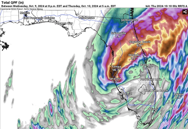
There are some incredible rainfall rates and amounts happening from roughly I4 north and the Turnpike west! I hope Milton doesn't slow too much!
|
cieldumort
Moderator
Reged:
Posts: 2497
Loc: Austin, Tx
|
|
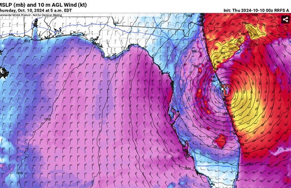
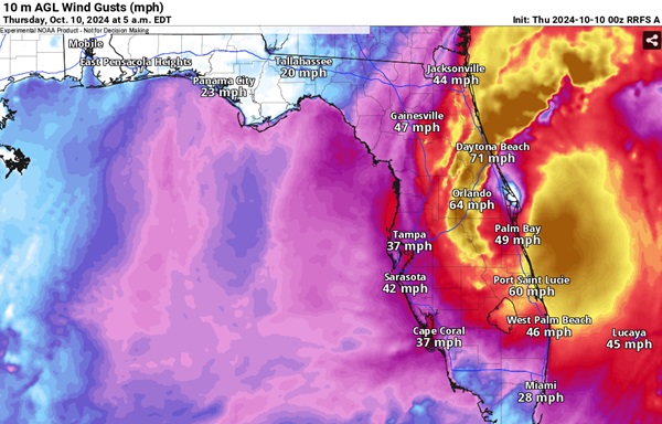
0z Rapid Refresh has the center of Milton just exiting the state about 5am EDT, still producing quite a lot of strong and damaging winds well inland and likely a lot of surge on the east coast of Florida as it does. This model also shows a for the area between 8pm Wednesday and 8pm Thursday that if anything is probably underdone. It looks like a lot of these numbers have already been realized on the west central Florida coast.
NON STANDARD MODEL
Convection Allowing RRFS A
|
JMII
Weather Master
Reged:
Posts: 546
Loc: Margate, Florida
|
|
Gotta hand to the they really nailed this track forecast. I calculated the spread from furthest N to furthest S center line was less then 60 miles, that is a crazy narrow window to focus on given the geographic scale of FL's gulf coast. Track errors favored a more northern solution that didn't verify in the end as Milton's wiggled his way SE. Advisory #5 from 10AM Sunday was basically spot on. Even the very the first advisory for TD#14 was almost perfect for landfall aside from timing (it was 12 hours too early). However (in my non-scientific opinion) in typical fashion they over stated wind speeds using flight level values which never translate to ground level. Data is hard to come by right now so I look forward to seeing the off-season report with official wind speeds. I believe this was closer to a Cat 2 as dry air thankfully weaken Milton. Of course the tends to avoid downgrading storms just before landfall fearing people will ignore "weak" storms.
I believe this storms legacy will be the insane number of strong tornadoes that were produced in central and eastern FL counties. And the so-called "miss" of Tampa Bay... again, despite the majority of plots putting Sarasota in the bull's eye. However we were only 20 to 30 miles from a completely different outcome.
None of this is to take away from the damage Milton caused and those lives that been sadly effected, just the perspective of someone who tracks these things with a high level of interest.
--------------------
South FL Native... experienced many tropical systems, put up the panels for:
David 79 - Floyd 87 - Andrew 92 - Georges 98 - Frances 04 - Wilma 05 - Matthew 16 - Irma 17
Lost our St James City rental property to Ian 22
|


 Threaded


