MikeC
Admin
Reged:
Posts: 4635
Loc: Orlando, FL
|
|
8:30PM EDT 9 October 2024 Update
Landfall has occurred near Siesta Key, Fl. :Quote:
...EXTREMELY DANGEROUS CATEGORY 3 HURRICANE MILTON MAKES LANDFALL
NEAR SIESTA KEY FLORIDA....
...LIFE-THREATENING STORM SURGE, EXTREME WINDS, AND FLASH FLOODING
OCCURRING OVER THE CENTRAL FLORIDA PENINSULA...
NWS Doppler radar data indicate the eye of Hurricane Milton has made landfall near Siesta Key in Sarasota County along the west coast of Florida.
A sustained wind of 78 mph (126 km/h) and a gust of 97 mph (156 km/h) was recently reported at a NOAA C-MAN station in Venice. A sustained wind of 77 mph (124 km/h) and a gust of 100 mph (161 km/h) was recently reported at a WeatherFlow station at Egmont Channel. A sustained wind of 67 mph (107 km/h) and a gust of 83 mph (133 km/h) was recently reported at a WeatherFlow station at Skyway Fishing Pier. A sustained wind of 40 mph (64 km/h) and a gust of 73 mph (117 km/h) was recently reported at the Sarasota-Bradenton International Airport.
The next update will be at 900 PM EDT (0100 UTC).
SUMMARY OF 830 PM EDT...0030 UTC...INFORMATION
-----------------------------------------------
LOCATION...27.3N 82.6W
ABOUT 5 MI...10 KM W OF SARASOTA FLORIDA
ABOUT 115 MI...185 KM SW OF ORLANDO FLORIDA
MAXIMUM SUSTAINED WINDS...120 MPH...205 KM/H
PRESENT MOVEMENT...ENE OR 60 DEGREES AT 15 MPH...24 KM/H
MINIMUM CENTRAL PRESSURE...954 MB...28.17 INCHES
1:30PM EDT 9 October 2024 Update
Time has mostly run out to safely prepare for life-threatening weather that is already spreading inland across the state, and now is the time to hunker down, away from the water ("Run from the water!"), and protected from the wind and debris ("Hide from the wind!") Quote:
Hurricane Milton Tropical Cyclone Update
NWS National Hurricane Center Miami FL AL142024
100 PM EDT Wed Oct 09 2024
...TROPICAL-STORM-FORCE WINDS JUST OFFSHORE THE WEST COAST OF FLORIDA...
...100 PM EDT POSITION UPDATE...
Milton is currently moving north-northeastward or 030/15 kt. A turn towards the northeast is anticipated with a slower forward speed later this evening.
Tropical-storm-force winds are just offshore and now is the time to stay inside and away from windows. Listen for updates and be ready in case you lose electrical power. Keep a battery-powered radio, charged cell phone and flashlight handy.
Ciel
4:55PM EDT 8 October 2024 Update
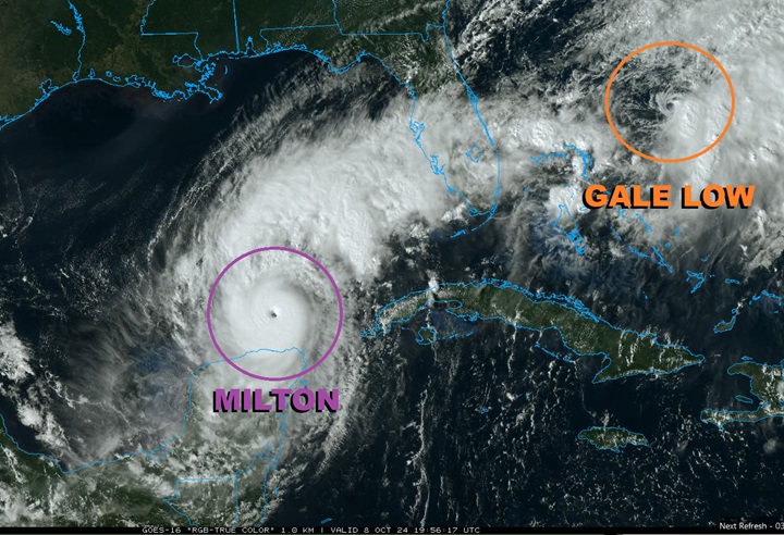
Hurricane Milton is Category 5 once again. Earlier today the cyclone completed an eyewall replacement and has been reorganizing at a dizzying pace. There is a slight shift to the south with the 18Z models, and indeed how it has been tracking overall, and the official cone is nudged a touch in that direction. Everyone is reminded that the hurricane is not itself a point or a line.
To Milton's northeast, an area of frontal boundary and lower pressure that in many ways had possibly been adding some extra tug to the north, is in the process of consolidating off the east coast of Florida and is now a stout gale low that may be acquiring some subtropical and tropical characteristics
Ciel
5:00PM EDT 7 October 2024 Update
HURRICANE AND STORM SURGE WARNINGS ISSUED FOR PORTIONS OF THE FLORIDA WEST COAST
SUMMARY OF 400 PM CDT...2100 UTC...INFORMATION
----------------------------------------------
LOCATION...21.8N 90.8W
ABOUT 80 MI...125 KM WNW OF PROGRESO MEXICO
ABOUT 675 MI...1085 KM SW OF TAMPA FLORIDA
MAXIMUM SUSTAINED WINDS...180 MPH...285 KM/H
PRESENT MOVEMENT...E OR 90 DEGREES AT 10 MPH...17 KM/H
MINIMUM CENTRAL PRESSURE...905 MB...26.73 INCHES
WATCHES AND WARNINGS
--------------------
CHANGES WITH THIS ADVISORY:
A Storm Surge Warning has been issued for the west coast of Florida from Flamingo northward to the Suwannee River, including Charlotte Harbor and Tampa Bay.
A Hurricane Warning has been issued for the west coast of Florida from Bonita Beach northward to the mouth of the Suwannee River, including Tampa Bay.
A Tropical Storm Warning has been issued for the west coast of Florida south of Bonita Beach to Flamingo, including Lake Okeechobee, and north of the mouth of the Suwannee River northward and westward to Indian Pass. A Tropical Storm Warning has also been issued for all of the Florida Keys, including the Dry Tortugas and Florida Bay.
A Storm Surge Watch has been issued for the U.S. east coast from Sebastian Inlet Florida to Edisto Beach South Carolina, including the St. Johns River.
A Hurricane Watch has been issued along the east coast of the Florida Peninsula from the St. Lucie/Indian River County Line northward to the mouth of the St. Marys River.
A Tropical Storm Watch has been issued along the east coast of the Florida Peninsula south of the St. Lucie/Indian River County Line southward to Flamingo. A Tropical Storm Watch has also been issued along the coast of Georgia and South Carolina from north of the mouth of the St. Marys River to South Santee River, South Carolina.
SUMMARY OF WATCHES AND WARNINGS IN EFFECT:
A Storm Surge Warning is in effect for...
* West coast of Florida from Flamingo northward to the Suwannee
River, including Charlotte Harbor and Tampa Bay
A Hurricane Warning is in effect for...
* Celestun to Rio Lagartos
* Florida west coast from Bonita Beach northward to the mouth of the
Suwannee River, including Tampa Bay
A Storm Surge Watch is in effect for...
* Sebastian Inlet to Edisto Beach, including St. Johns River
A Hurricane Watch is in effect for...
* Rio Lagartos to Cabo Catoche
* Campeche to south of Celestun
* Dry Tortugas
* Lake Okeechobee
* Florida west coast from Chokoloskee to south of Bonita Beach
* Florida east coast from the St. Lucie/Indian River County Line
northward to the mouth of the St. Marys River
A Tropical Storm Warning is in effect for...
* Rio Lagartos to Cancun
* Campeche to south of Celestun
* All of the Florida Keys, including Dry Tortugas
* Lake Okeechobee
* Florida west coast from Flamingo to south of Bonita Beach
* Florida west coast from north of the mouth of the Suwanee River to
Indian Pass
A Tropical Storm Watch is in effect for…
* East coast of the Florida Peninsula south of the St. Lucie/Indian
River County Line southward to Flamingo
* Coast of Georgia and South Carolina from north of the mouth of the
St. Marys River to South Santee River, South Carolina
11:55AM EDT 7 October 2024 Update
Milton is now Cat 5 on the Saffir-Simpson Wind Scale.
Ciel
9:15AM EDT 7 October 2024 Update
Milton continues to RI and recon has just found that the Major Hurricane is up to 150 MPH, still strengthening. There continues to be indications that an eyewall replacement cycle could occur today, and this would result in a process that makes Milton larger and an even greater storm surge producer on Florida.
Preps to protect life and property should be rushing to completion today.
Ciel
4:45PM EDT 6 October 2024 Update
A Hurricane Watch has been issued for the northern coast of the Yucatan Peninsula and Watches and Warnings will likely be issued for portions of Florida within the next 6-12 or so hours.
Milton is now forecast by to peak at 145 MPH (mid-range Cat 4 on the Saffir-Simpson Wind Scale), but as noted in their discussion, this could be conservative, and Cat 5 is solidly on the table. In fact, some of our better hurricane models are now in the high-end Cat 5 range (what many might call "Cat 6").
Putting the wind threat aside for a moment, which is very high, it is forecast that Milton begins its extra-tropical transition phase prior to landfall, or at the very latest, prior to entering the east coast of Florida. This transitional period is expected to result in lowering the hurricane's top-line max wind speeds, but come at a cost to all of a wind field that spreads out, producing damage over an even greater area, as well as producing surge much further up and down the coasts than if the core held tightly.
Also, the threat of inland flooding will be substantial. The PRE event that has set up in advance of Milton's approach is already producing flooding, and this will be exacerbated during the landfall and passage of Milton.
Those living in or with interests in Florida from the Big Bend region all the way to the South Florida Keys are encouraged to begin taking preparations to protect life and property.
Ciel
1:45PM EDT 6 October 2024 Update
Recon has confirmed that Milton is now a hurricane and is updating the new Advisory at this time.
Ciel
8:00AM EDT 6 October 2024 Update
NOAA Recon aircraft finds Milton stronger with 991mb pressure and 60mph winds. Forecast track remains mostly unchanged, models should tighten up a bit better later today (not until after the 12Z runs) with recon data added in. Those in the Florida peninsula in the cone should make preparations today and tomorrow. Hurricane watches for some areas of Florida may be issued sometime tonight or tomorrow.
12:25PM CDT Update
TD 14 has become Tropical Storm Milton.
10:15AM Update
Advisories for TD#14 to begin at 11AM EDT.
Original Update
The area in the southwestern Gulf of Mexico is now up to a 90% chance to develop, and those along the west coast of Florida should watch it closely as the potential is developing for it to possibly a bad one for somewhere along the southwest or Western Central Florida coastline, and also impact the peninsula to the Atlantic. Including Tampa.
Models range from Naples to near Crystal River, with the angle coming from the west not as oblique as the ones from the West Caribbean, there may be a little more accuracy in track once advisories start to be issued, which could start later tonight or tomorrow depending on how much the system develops.
Timing is most likely for a Wednesday landfall with impacts being felt a day or two (or even Sunday) before in the form of very heavy rain, and more impacts toward later Tuesday surge and wind, with landfall likely daytime Wednesday (which could change)
The worst surge impacts at landfall will likely be at and just to the right (south) of the landfall point, on exit into the Atlantic that switches to the left (north) side with onshore winds.
MILTON FORECAST LOUNGE
News Media (East Central Florida):
Television:
Newspapers:
News Radio:
Check local media and officials when a storm is approaching your area.
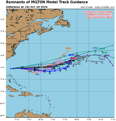
Edited by cieldumort (Thu Oct 10 2024 12:05 AM)
|
MikeC
Admin
Reged:
Posts: 4635
Loc: Orlando, FL
|
|
First recon in Milton just found a 986mb extrapolated pressure on the recon pass and a 993mb at . 22.6N 94.9W vortex dropsonde message, quite a bit deeper than the 1003mb on the 5am advisory, which means Milton is structurally very sound.
Edited by CFHC (Sun Oct 06 2024 09:24 AM)
|
danielw
Moderator

Reged:
Posts: 3527
Loc: Hattiesburg,MS (31.3N 89.3W)
|
|
Wind speed at 60 mph and they went with 991 mb pressure.
I've seen some questions on Facebook regarding Storm Debris from Helene and it's disposal prior to Milton's arrival.
This may help.
Milton Emergency Declaration
Edited by danielw (Sun Oct 06 2024 08:20 AM)
|
cieldumort
Moderator

Reged:
Posts: 2497
Loc: Austin, Tx
|
|
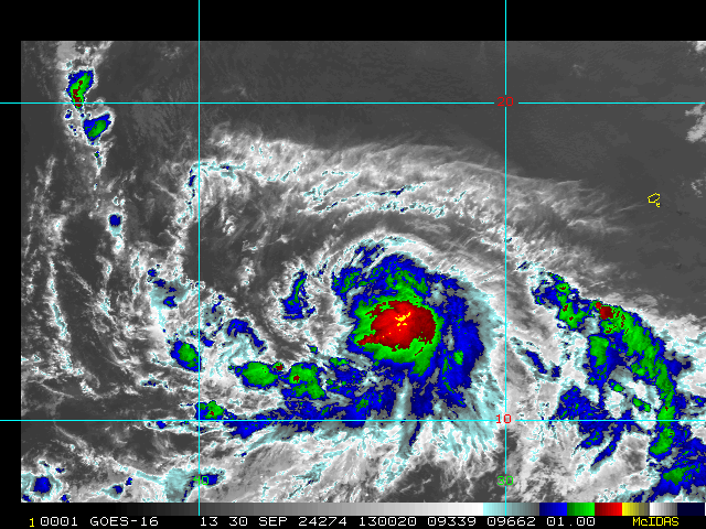
The last pass from Mission 1 into Milton confirmed that a 20nm circular eye has formed
Product: NOAA Vortex Message (URNT12 KWBC)
Transmitted: 6th day of the month at 13:59Z
Agency: National Oceanic and Atmospheric Administration (NOAA)
Aircraft: Lockheed WP-3D Orion (Reg. Num. N43RF)
Storm Name: Milton
Storm Number & Year: 14 in 2024 (flight in the North Atlantic basin)
Mission Number: 1
Observation Number: 18
A. Time of Center Fix: 6th day of the month at 13:25:41Z
B. Center Fix Coordinates: 22.55N 94.51W
B. Center Fix Location: 217 statute miles (348 km) to the E (85°) from Tampico, Tamaulipas, Mexico.
C. Minimum Height at Standard Level: 3,026m (9,928ft) at 700mb
D. Minimum Sea Level Pressure: 991mb (29.27 inHg)
E. Dropsonde Surface Wind at Center: From 80° at 5kts (From the E at 6mph)
F. Eye Character: Open in the southwest
G. Eye Shape & Diameter: Circular with a diameter of 20 nautical miles (23 statute miles)
|
CFHC

Reged:
Posts: 164
Loc: East Central Florida
|
|
Recon just found a 951.3mb pressure. Milton is going up fast.
|
MikeC
Admin
Reged:
Posts: 4635
Loc: Orlando, FL
|
|
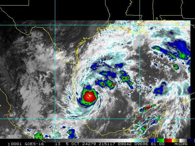
...NOAA HURRICANE HUNTERS FIND MILTON A MAJOR HURRICANE...
Data from a NOAA Hurricane Hunter aicraft indicate that Milton has
strengthened to a major hurricane. The maximum sustained winds are
estimated to be 120 mph (195 km/h). Milton is a category three
hurricane on the Saffir-Simpson Hurricane Wind Scale. Data from
the aircraft also indicate that the minimum pressure has fallen to
954 mb (28.17 inches).
A special advisory will be issued by 7 AM CDT (1200 UTC) to reflect
this change and update the forecast.
|
Steve H1
Storm Tracker
Reged:
Posts: 310
Loc: Palm Bay FL USA
|
|
And with the pinhole eye, it is possible that Milton will hit category 5. It is interesting to note that the shear forecast has has dropped from 51 knots to 38 knots as it approaches the west coast. These shear numbers suggest that Milton may not weaken as much as predicted. Also note that shear forecasting is not always accurate, whether higher or lower.
|
cieldumort
Moderator
Reged:
Posts: 2497
Loc: Austin, Tx
|
|
|
cieldumort
Moderator
Reged:
Posts: 2497
Loc: Austin, Tx
|
|
Product: NOAA Vortex Message (URNT12 KWBC)
Transmitted: 7th day of the month at 22:41Z
Agency: National Oceanic and Atmospheric Administration (NOAA)
Aircraft: Lockheed WP-3D Orion (Reg. Num. N42RF)
Storm Name: Milton
Storm Number & Year: 14 in 2024 (flight in the North Atlantic basin)
Mission Number: 10
Observation Number: 03
A. Time of Center Fix: 7th day of the month at 22:20:04Z
B. Center Fix Coordinates: 21.86N 90.67W
B. Center Fix Location: 93 statute miles (149 km) to the NW (312°) from Mérida, Yucatán, Mexico.
C. Minimum Height at Standard Level: Not Available
D. Minimum Sea Level Pressure: 899mb (26.55 inHg)
E. Dropsonde Surface Wind at Center: From 220° at 24kts (From the SW at 28mph)
F. Eye Character: Closed
G. Eye Shape & Diameter: Circular with a diameter of 4 nautical miles
H. Estimated (by SFMR or visually) Maximum Surface Wind Inbound: Not Available
I. Location & Time of the Estimated Maximum Surface Wind Inbound (Undecoded): NA
J. Maximum Flight Level Wind Inbound: From 160° at 135kts (From the SSE at 155.4mph)
K. Location & Time of the Maximum Flight Level Wind Inbound: 4 nautical miles to the ENE (58°) of center fix at 22:18:51Z
L. Estimated (by SFMR or visually) Maximum Surface Wind Outbound: Not Available
M. Location & Time of the Estimated Maximum Surface Wind Outbound (Undecoded): NA
N. Maximum Flight Level Wind Outbound: From 322° at 161kts (From the NW at 185.3mph)
O. Location & Time of the Maximum Flight Level Wind Outbound: 4 nautical miles to the WSW (237°) of center fix at 22:21:09Z
P. Maximum Flight Level Temp & Pressure Altitude Outside Eye: 13°C (55°F) at a pressure alt. of 3,054m (10,020ft)
Q. Maximum Flight Level Temp & Pressure Altitude Inside Eye: 27°C (81°F) at a pressure alt. of 3,030m (9,941ft)
R. Dewpoint Temp (collected at same location as temp inside eye): 16°C (61°F)
R. Sea Surface Temp (collected at same location as temp inside eye): Not Available
S. Fix Determined By: Penetration, Radar, Wind, Pressure and Temperature
S. Fix Level: 700mb
T. Navigational Fix Accuracy / Meteorological Accuracy (Undecoded): 0.01 / NA
Remarks Section:
Maximum Flight Level Wind: 161kts (~ 185.3mph) which was observed 4 nautical miles to the WSW (237°) from the flight level center at 22:21:09Z
|


 Threaded


