New Article: CSU releases 2026 season numbers, slightly below average. https://flhurricane.com
Days since last Hurricane Landfall —
US Any:
575 (Milton),
US Major:
575 (Milton),
FL Any:
575 (Milton),
FL Major:
575 (Milton)
cieldumort
Moderator

Reged:
Posts: 2664
Loc: Austin, Tx
|
|

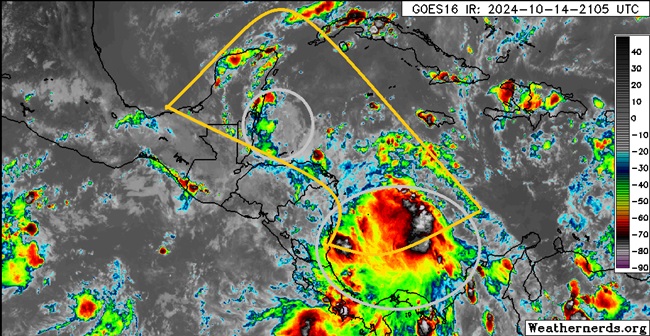
Above: A pair of convectively active to at times very convectively active vorticity lobes in the western Caribbean circled in gray, and the rough outline of greatest potential for a broad area of low pressure to form this week outlined in deep yellow.
A broad area of low pressure has been advertised by many models to form in the western or northwestern Caribbean sometime this week, and a tropical cyclone could form in conditions that are already favorable for genesis. Of the two vorticity lobes in the image above, the one more likely to have sufficient time to cook over water is the southern features, but both have a shot. Alternatively, a new lobe could also emerge that would stand the best chance.
This region is not yet Invest tagged, but should a more cohesive disturbance evolve as many model runs foresee, would likely assign one at that time and the title would be updated accordingly.
At the moment, this looks like a possible central America to Yucatan threat more than anywhere else, with blocking high pressure shutting down any immediate entryway to the US.
This is now Invest 95L on 10-17 and the title has been updated accordingly
2024-10-17 18:00 15.9 -82.0 20
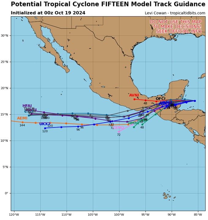
Invest 95L is now Invest Potential Tropical Cyclone FIFTEEN and the title has been updated
2024-10-18 18:00 17.5 -84.6 30
Nadine
100 AM CDT Sat Oct 19 2024
17.3N 86.4W
1004 MB
Ciel
More details to come
Edited by cieldumort (Sat Oct 19 2024 02:04 AM)
|
cieldumort
Moderator

Reged:
Posts: 2664
Loc: Austin, Tx
|
|
This feature has been Invest tagged on 10-17 and the title is being updated.
Organization has increased some today with what was the southern lobe, now tracking WNW to NW. Over the coming weekend this could become a concern for portions of central America and the Yucatan, including a risk of flooding.
|
cieldumort
Moderator

Reged:
Posts: 2664
Loc: Austin, Tx
|
|

|
cieldumort
Moderator

Reged:
Posts: 2664
Loc: Austin, Tx
|
|
Tropical Storm Nadine Tropical Cyclone Update
NWS National Hurricane Center Miami FL AL152024
1100 AM CDT Sat Oct 19 2024
...NADINE MAKES LANDFALL IN BELIZE...
Satellite and radar images indicate that Nadine has made landfall
in Belize, near Belize City around 1100 am CDT (1600 UTC). The
maximum sustained winds are near 60 mph (95 km/h) based on data
from the Air Force Hurricane Hunters and surface observations.
A weather station in San Pedro in the southern Yucatan Peninsula
recently reported a sustained wind of 55 mph (89 km/h) and a gust
to 67 mph (107 km/h).
Tropical-storm-conditions are expected across Belize and the Yucatan
Peninsula through the afternoon.
SUMMARY OF 1100 AM CDT...1600 UTC...INFORMATION
-----------------------------------------------
LOCATION...17.4N 88.3W
ABOUT 10 MI...15 KM SW OF BELIZE CITY
ABOUT 75 MI...120 KM S OF CHETUMAL MEXICO
MAXIMUM SUSTAINED WINDS...60 MPH...95 KM/H
PRESENT MOVEMENT...W OR 270 DEGREES AT 8 MPH...13 KM/H
MINIMUM CENTRAL PRESSURE...1002 MB...29.59 INCHES
$$
Forecaster Cangialosi/Torres-Vazquez/Delgado
|
|
0 registered and 7 anonymous users are browsing this forum.
Moderator:
Print Topic
|
Forum Permissions
You cannot start new topics
You cannot reply to topics
HTML is disabled
UBBCode is enabled
|
Rating:
Topic views: 5908
|
|
|
|
|
|
Note: This is
NOT an official page. It is run by weather hobbyists and should not be used as a replacement for official sources.
CFHC's main servers are currently located at
Hostdime.com in Orlando, FL.
Image Server Network thanks to Mike Potts and Amazon Web Services. If you have static file hosting space that allows dns aliasing contact us to help out! Some Maps Provided by:
Great thanks to all who
donated and everyone who uses the site as well.
Site designed for 800x600+ resolution
When in doubt, take the word of the
National Hurricane Center
G