MikeC
Admin
Reged:
Posts: 4627
Loc: Orlando, FL
|
|
10:30PM Update
Alex is the first Major Hurricane of the season, safely away from lland, but at an impressive 120MPH it's not a Category 3 storm.
Former Tropical Depresison... Persistance is the key. Will it slow down and reorganize or fall apart? This weakening could alow is to slip under. But I still don't see much for it.
Original Update
Alex still has a great deal of life in after brushing Cape Hatteras, it's moving away from us, but it's restrenghtened to its strongest yet, with 105MPH maximum sustained winds. As a hurricane, Alex won't be bothering any more folks on land however. It got a little intense on the Outer Banks for sure.
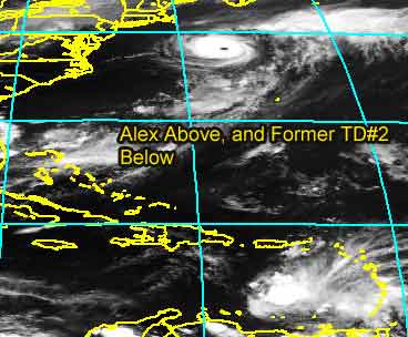
And our super speed depression down in the Caribbean has fallen apart, and is now in the eastern Caribbean "Hurricane Graveyard". The forward speed of the depression was too great, and its so enlongated and disorganized, i don't see any chance of a recovery for it as it stands now. Persistance is the key, and it has stayed persistantly disorganized. The remains will be something to look at for a while though. My bet, nothing comes of it.
General Links
Current Aircraft Recon Info
NRL Monterey Marine Meteorology Division Forecast Track of Active Systems (Good Forecast Track Graphic and Satellite Photos)
Check the Storm Forum from time to time for comments on any new developing system.
Follow worldwide SST evolution here:
Global SST Animation
NASA GHCC Interactive Satellite images at:
North Atlantic Visible (Daytime Only), Infrared, Water Vapor
LSU Sat images
Some forecast models:
NGM, AVN, MRF, ETA ECMWF
AVN, , , JMA, , UKMET
DoD Weather Models (NOGAPS, AVN, MRF)
Multi-model plots from WREL
Other commentary at Independentwx.com, Robert Lightbown/Crown Weather Tropical Update Accuweather's Joe Bastardi (now subcriber only unfortunately), Hurricane Alley North Atlantic Page, Cyclomax (Rich B.), Hurricane City , mpittweather , Gary Gray's Millennium Weather, storm2k, Barometer Bob's Hurricane Hollow, Snonut,
Even more on the links page.
|
Cycloneye
Storm Tracker
Reged:
Posts: 373
Loc: Puerto Rico
|
|
Well Alex is in it's final life as a hurricane then TD#2 fell apart but now a new system will be the most talked in comming days as ALL global models agree on developing it.
TROPICAL WAVE INTRODUCED OVER THE E ATLC W OF DAKAR NEAR 20W S
OF 16N MOVING W 10 KT. YESTERDAY EVENING'S SOUNDING FROM DAKAR
HAD A 55 KT JET CORE AT 600 MB ASSOCIATED WITH THE WAVE... QUITE
A POWERFUL SYSTEM. COMPUTER MODELS ARE HINTING THAT THIS IS A
SYSTEM TO MONITOR WITH A /UKMET/NOGAPS/CMC CONSENSUS
SUGGESTING SOME SORT OF SURFACE LOW WILL DEVELOP IN THE NEXT 36
HOURS ALONG THIS WAVE AXIS. ONLY CONVECTION AT PRESENT.
--------------------
My 2004 hurricane season forecast=13/8/3
Edited by Cycloneye (Wed Aug 04 2004 08:13 PM)
|
LI Phil
User

Reged:
Posts: 2637
Loc: Long Island (40.7N 73.6W)
|
|
Don't forget to check the comedy forum
--------------------
2005 Forecast: 14/7/4
BUCKLE UP!
"If your topic ain't tropic, your post will be toast"
|
cyclone_head
Weather Hobbyist

Reged:
Posts: 74
Loc: Florida
|
|
I know...I need to get a life but does it seem there is a flare-up that is actually easterly of what was formerly TD#2? Earlier there seemed to be more dry air surrounding TD2 from all sides but I see a westerly trough closing in and storm activity that developed along the coast of South America.. There is still nothing but dry air to the east but could the center of former TD2 be reforming east of the earlier center as we knew it?
Here is the WVL...
http://www.goes.noaa.gov/HURRLOOPS/huwvloop.html
|
danielw
Moderator

Reged:
Posts: 3527
Loc: Hattiesburg,MS (31.3N 89.3W)
|
|
I'm not convinced TD2 is falling apart. The SAT loops all show a like structure on the Southern side of the storm. In the last hour all the lightning has shifted to this area, which is located just N of Bonaire. I'm not a Met., but if the convection on the western side is set up just right won't it block some of the shear? Think may have to rethink the recon for tomorrow. Like sunrise maybe! Waiting and watching.
note:As of 0200Z there appears to be a NW wind component shaping up on the SW side. Could the circ. be closing??
Edited by danielw (Wed Aug 04 2004 10:02 PM)
|
recmod
Weather Guru

Reged:
Posts: 188
Loc: Orlando, FL
|
|
NRL now lists Alex at 105 knots with a central pressure of 957 mb
--Lou
|
LI Phil
User
Reged:
Posts: 2637
Loc: Long Island (40.7N 73.6W)
|
|
WOW!
Just updated the 2004 "so far" numbers
--------------------
2005 Forecast: 14/7/4
BUCKLE UP!
"If your topic ain't tropic, your post will be toast"
|
jth
Storm Tracker
Reged:
Posts: 275
|
|
That flare up is exactly where I thought I saw a LLC earlier. Notice that the forward motion of that area has really slowed. Could be wrong, but I think TD2 is going to make a comeback.
|
EriktheFled
Unregistered
|
|
If the Wave Formerly Known as TD2 doesn't develop in the Atlantic, I still hold out hope for it to become the first major hurricane of the season in the NEP.
Really, aside from the Carib. wave, I don't see anything on the horizon for a week at least, barring some unusual development for the ragged remnants of the Cape Verde wave.
|
BillD
User
Reged:
Posts: 398
Loc: Miami
|
|
I'm not sure that we ever knew where the center was, or even if there really was one. I think TD2 is still with us, there is at least still some mid-level circulation. The fact that it is so close to land to the south is not helping it any.
Bill
|
cyclone_head
Weather Hobbyist
Reged:
Posts: 74
Loc: Florida
|
|
>"Anyone think this is a CAT III?" posted at 4:39 pm by Phil
Was this an accurate forcast Phil? Think so... as it turned out...
|
danielw
Moderator
Reged:
Posts: 3527
Loc: Hattiesburg,MS (31.3N 89.3W)
|
|
Take a look.
http://www.srh.noaa.gov/radar/latest/DS.p19r0/si.tjua.shtml
|
Old Sailor
Storm Tracker

Reged:
Posts: 293
Loc: Florida
|
|
TD#2 could reform , but the wind shear is very strong in western Cari. wait and see, with a strong cold(cool) front coming all the way down to Florida, This time of year any cold front that makes it to GOM tends to cause a problem early to mid week 9 to 12th.
Dave
|
danielw
Moderator
Reged:
Posts: 3527
Loc: Hattiesburg,MS (31.3N 89.3W)
|
|
Nice shot. Look a the size and shape of XTD2 on this WV shot from LSU at 0145Z.
http://antares.csi.lsu.edu/webpics/goes/Storm/Tropics/latest_wv.jpg
|
Tropics Guy
Storm Tracker

Reged:
Posts: 252
Loc: Miami, Florida
|
|
Think that EX-TD#2 is not dead yet, seems to have slowed down, and a nice ball of convection has developed near the center. Shear needs to lessen & it needs to gain a little bit more latitude before we see any significant development, we'll see what it looks like in the AM.
nite, yall

TG
--------------------
Tropical Cyclones: "Mother nature's heat transfer machines"
|
LI Phil
User
Reged:
Posts: 2637
Loc: Long Island (40.7N 73.6W)
|
|
Quote:
>"Anyone think this is a CAT III?" posted at 4:39 pm by Phil
Was this an accurate forcast Phil? Think so... as it turned out...
Yes, and for once, this was NOT just a crazy, hurricane mongering wishcast. I mean, it was close enough to CAT III status as it was.
Now, if I could just get it right with TD2...
--------------------
2005 Forecast: 14/7/4
BUCKLE UP!
"If your topic ain't tropic, your post will be toast"
|
BillD
User
Reged:
Posts: 398
Loc: Miami
|
|
I'll admit anything could happen at this point. But look at the current WV loop, right now what-was-TD2 is only getting some shear on the leading edge. In fact, it is taking up the entire eastern Caribbean Sea from SA to PR (you can see its effects on PR radar). That is not some wimpy wave that is going to fizzle.
If it does not develop and isn't pulled northward by the trough, then the shear in the western Caribbean will probably tear it up, but I don't think it will ever get that far west.
Bill
|
javlin
Weather Master
Reged:
Posts: 410
Loc: Biloxi,MS
|
|
I saw the WC channel tonite Lyons said Gulfstream was to fly around the system not thru it.They are rethinking the track I believe.He mentioned they wanted to no more about the surronding eviroment.I am not saying this going to happen by no means but Camille made S of Cuba as wave .I mention a few forums ago that it was thought that the unusal cool front had some kind of impact on her development.Just drawing parallels every year and every system is different but the date 8/17 uncanny.Let it go at that just food for thought.
|
danielw
Moderator
Reged:
Posts: 3527
Loc: Hattiesburg,MS (31.3N 89.3W)
|
|
Javelin, you are certainly correct with reference to Camille.
"Camille was detected by satellite on August 14, 1969, as a tropical disturbance moving west in the Caribbean Sea. Early on the 15th, Camille became a strengthening hurricane while located off the western tip of Cuba.'"
Storm CAMILLE is number 3 of the year 1969
August 14 18 UTC 19.4N 82.0W -- deg -- mph -- kph 60 mph 95 kph 991 mb Tropical Storm
I haven't been able to find the data the Gulfstream found. I have noticed over the last 4 hrs that the western edge of TD2 is round, not jagged and ragged as before. The WV shot I listed above shows an almost complete circle. The exception being S America.
Who was is that said CAT V earlier today?
Edited by danielw (Thu Aug 05 2004 12:07 AM)
|
HanKFranK
User

Reged:
Posts: 1841
Loc: Graniteville, SC
|
|
dude, did you just relate the remnants of a tropical depression to hurricane camille? you might want to rethink the parallels.. cause they're about like relating a little league baseball player to a hall of famer. sure, it's infinitesmally possible, just not credible by any standard.
mjo be damned, we seem to be in an active span. either t.d. 2's remains have made one of the most dramatic slowdowns i've ever seen or this is a trick of IR imagery. i've eyeballed it on IR ch2 and the stuff i was guessing earlier.. that the proximity to land is aiding in causing drag on the south of the system, and that the wave axis is leaning forward as opposed to tailing back to the north like they usually do.. that stuff checks out. but really until the visibles tomorrow come out there won't be any strong clues as to what is going on with the blow up that is now less than 100mi north of isla de margarita (which inspires thoughts of jimmy buffett). they'll probably recon it unless the convection decays overnight (in which case the system would more than likely be beyond recovery). great uncertainty.. tomorrow should decide whether this thing goes away or becomes a bother.
alex is present proof that stuff can happen at high latitudes, and that when a sheared hurricane travels with the flow, it can still crank way up. i don't expect it to get a great deal stronger.. whatever is left of it will probably give the british isles a good shellacking monday-tuesdayish.
92L has a good low level turning and persistent local convection.. and it is not long before it will be over good support waters. i've got an inkling it might be the next depression by saturday, if things continue improving. also, note.. it is not going interminably NW like the models progged it to. is actually on a slightly south of due west trajectory... for the moment. should be near/north of the islands around sunday.
new wave coming off has all kinds of global support, and earlier folks were quoting the discussion mention of an impressive signature as it passed dakar. it's on the short waiting list, models have it developing a surface low near the /35w or so by saturday.
heed what ol' sailor says about what gets left behind in the gulf, or off the eastern seaboard. there will probably be an earlier split of the trough than progged by .. trend is going that way so far.. so look for an area of disturbed weather early/middle next week near the southeastern u.s.
i should get some sleep now. night folks.
HF 0353z05august
|


 Threaded


