Anonymous
Unregistered
|
|
think bonnie may have jumped to the ne a little in the last few hrs.... storms are coming back on center... recon should have new fix in little bit....
I hear TS watch and possible Hurr Watch might be going up tonight from mobile east to cedar key.....
|
mikeG
Unregistered
|
|
Station 42001 - MID GULF 180 nm South of Southwest Pass, LA ****25.84 N 89.66 W (25°50'30"N 89°39'30"W)
winds from SE ( 140 deg true )
Wind Speed (WSPD): 3.9 kts
Wave Height (WVHT): 4.6 ft **here come the swells***
|
James88
Weather Master

Reged:
Posts: 576
Loc: Gloucestershire, England, UK
|
|
Looks like may be having a few problems this evening. He's coughed up some outflow boundaries to the NE and NW, whice is not a good sign for significant development. Once this storm begins to slow down, it should start to consolidate some more.
Edited by James88 (Tue Aug 10 2004 03:27 PM)
|
Anonymous
Unregistered
|
|
URNT11 KNHC 101918
97779 19184 31257 92018 15300 99005 18169 /2536 49905
RMK AF977 0502A BONNIE OB 11
URNT11 KNHC 101914
97779 19144 30160 71800 02900 07038 26213 /0009 40635
RMK AF966 0103A OB 15
|
LI Phil
User

Reged:
Posts: 2637
Loc: Long Island (40.7N 73.6W)
|
|
Anybody know why SSD still hasn't posted the 1745 UTC T's?
--------------------
2005 Forecast: 14/7/4
BUCKLE UP!
"If your topic ain't tropic, your post will be toast"
|
Anonymous
Unregistered
|
|
URNT14 KNHC 101919
SUPPLEMENTARY VORTEX DATA MESSAGE
01236 10896 12542 11810 22031
02237 20898 22538 21712 23033
03239 30900 32530 31716 22031
04241 40902 42523 41817 22029
05243 50904 52510 51817 23037
MF243 M0905 MF043
OBS 01 AT 1822Z
OBS 05 AT 1840Z
OBS 01 SFC WND 99005
01246 10908 12496 12018 04033
02248 20910 22518 21817 06018
03250 30912 32524 31916 03017
04251 40914 42529 41813 05019
05253 50916 52531 51815 04015
06255 60918 62534 61815 05011
07257 70920 72534 71716 99005
MF246 M0908 MF033
OBS 01 AT 1849Z
OBS 07 AT 1917Z
OBS 07 SFC WND 99005
RMK AF977 0502A BONNIE OB 12
|
BugsBunny
Weather Watcher

Reged:
Posts: 42
Loc: Florida
|
|
Charley is now experiencing northeasterly shear and outflow boundaries are racing away from the storm.
still not that well organized
--------------------
forecast: 17/14/9/5
to date: 3/3/2/1
|
Larry
Weather Watcher
Reged:
Posts: 30
Loc: Raleigh, NC
|
|
Agree with Anon - the last frame of this loop seems to show the moving to NNE. If you hold your cursor over the ending position, it does seem to be an actual movement and not an illusion caused by cloud movement. Maybe just a temporary motion, who knows 
Gulf visible loop
Larry
|
wxman007
Meteorologist
Reged:
Posts: 617
Loc: Tuscaloosa, AL
|
|
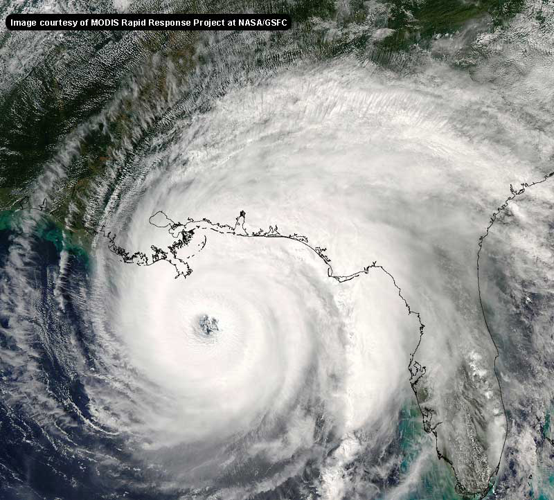
Looks like the majority of west vector is out of Bonnie's current track and she is now "feeling" the 1st trough...and behaving accordingly. After getting knocked down this morning, the shear is now relaxing, and the satellite presentation is really improving over the last few hours. The next 12 hours are going to be very telling. If the shear is relaxing as much as I think it is, some significant strengthening is about to get underway, as per the , which is doing a very good job with this system. (New Vortex as I type this, winds down, but pressure down to 1004 mb too...).
Things are about to get pretty busy here in the next few hours at my location...I'll be happy to answer as many questions as I can, but will probably limit my commentary to answering questions as time allows...I probably won't have time to do summary posts.
If there is anything I can do to help anyone out, just let me know.
--------------------
Jason Kelley
|
SirCane
Storm Tracker

Reged:
Posts: 249
Loc: Pensacola, FL
|
|
http://maps.wunderground.com/data/images/at200402_sat.jpg
--------------------
Direct Hits:
Hurricane Erin (1995) 100 mph
Hurricane Opal (1995) 115 mph
Hurricane Ivan (2004) 130 mph
Hurricane Dennis (2005) 120 mph
http://www.hardcoreweather.com
Edited by LI Phil (Tue Aug 10 2004 04:18 PM)
|
jth
Storm Tracker
Reged:
Posts: 275
|
|
I agree ...Here we go on both systems. The outflow boundaries mentioned earlier for are actually a good thing. these originated from the preceeding band of thunderstorms that may have been inhibiting development of a true . look for the to really improve with both systems soon.
As for the tracks...Will bonnie go north for a while before turning NE??? if so, Mobile to Destin. if not, Destin to Appalachi.
Charley continues a steady pace to the WNW. He will be a major force in the central gulf in a few days.
|
bobbi
Unregistered
|
|
ok.. bear with me here please as I think its interesting to see what we thought TD2 would do back when.. as I think there are similarities. Also..outflow boundaries are bad but occur for different reasons and can be a sign either way that something is going on..
they say hindsight is 2020 well use it to see what was wrong and what is going on now..
remember the track from TD2 and everyone thought it would cut up across cuba somewhere similar to where looks to be doing now
so is sticking to the old plan or current NOAA plan?
(the quiet time is over...stick to the topic)
Edited by LI Phil (Tue Aug 10 2004 04:10 PM)
|
bobbi
Unregistered
|
|
not sure 100% what is going on but it has lifted and cleared South America and that was I believe inhibiting her. When you have a system so large and the bottom half can't form but the northern part is out of control.. its not good.
some ways he looks better, some
where are the planes, what are they saying?
|
rickonboat
Weather Hobbyist
Reged:
Posts: 90
|
|
maybe now we will dispense with the dissipating theories and suppositions and get to the real crux of the matter.
appreciate the post by Jason Kelly..
hopefully Bonnie won't get too nasty. However, anyone who knows the gulf of Mexico storms, and the tight eye of this one...and taking into consideration all that has been said...
maybe stronger than a cat 2 is possible?
whatya'llthankaboutthat?
|
Anonymous
Unregistered
|
|
Quote:
maybe stronger than a cat 2 is possible?
whatya'llthankaboutthat?
Man I don't want an Opal type situation.
|
LI Phil
User

Reged:
Posts: 2637
Loc: Long Island (40.7N 73.6W)
|
|
>>> maybe stronger than a cat 2 is possible?
>>> whatya'llthankaboutthat?
I thank we need to get serious (did I just say that). Geez the Rabbit dissipates every system and you send them toward Mobile as CAT Vs. I suppose it is entirely possible, given the right circumstances and the temp of the Gulf, strengthening above a II is possible. Lets hope not. Jason's wearing the bullseye so far, so we should probably listen to him. Whatever happens, though, this is starting to get serious...
--------------------
2005 Forecast: 14/7/4
BUCKLE UP!
"If your topic ain't tropic, your post will be toast"
|
rickonboat
Weather Hobbyist
Reged:
Posts: 90
|
|
I'm not one to make everyone nervous...just aware. BY NO MEANS, living on a trawler at Dog River, in Mobile Bay, am I hoping this thing hits Mobile as anything more than a nasty 40 mph squall. However, since I am in a vulnerable position, I don't have a lot of time to decide to head up the river, or ride it out. Hence, my feelings that as long as any scenario is possible, plan for the worst, and hope for the best. My gut feeling is that, yes, it is quite possible the storm could explode to a cat 3, but was hoping for the "experts" to validate my worst nightmarish possiblities.
time will tell......
Perhaps I will be positioned inland a few miles.....on top of an oak tree. we shall see....
|
summercyclone
Weather Hobbyist

Reged:
Posts: 69
Loc: Florida Big Bend
|
|
Looks like Bonnie has fluctuated but in the most recent pics and obs, seems to be coming back and basically stationary or moving Nward.
sc 
|
Frank P
Veteran Storm Chaser
Reged:
Posts: 1299
|
|
last recon reports pressure down to 999, max flt winds 42k
|
Anonymous
Unregistered
|
|
URNT12 KNHC 101947
VORTEX DATA MESSAGE
A. 10/1947Z
B. 15 DEG 11 MIN N
70 DEG 27 MIN W
C. NA
D. 35 KT
E. 303 DEG 92 NM
F. 068 DEG 42 KT
G. 302 DEG 084 NM
H. EXTRAP 999 MB
I. 25 C/ 292 M
J. 26 C/ 287 M
K. 25 C/ NA
L. NA
M. NA
N. 1234 /01
O. .1/2 NM
P. AF966 0103A OB 16
MAX FL WIND 42 KT NW QUAD 1917Z SLP EXTRAP FROM 1500FT.
Bill
|


 Threaded


