LI Phil
User

Reged:
Posts: 2637
Loc: Long Island (40.7N 73.6W)
|
|
Three flights each for tomorrow...
recon
JK, you're fast...
--------------------
2005 Forecast: 14/7/4
BUCKLE UP!
"If your topic ain't tropic, your post will be toast"
Edited by LI Phil (Tue Aug 10 2004 07:28 PM)
|
rickonboat
Weather Hobbyist
Reged:
Posts: 90
|
|
If Bonnie's direction is NNW, it would appear that there is still a possibility of a more westerly landfall? Anyone think that is possible?...just wondering what I need to do in way of preparation. I don't have a good feel for this storm at all.
|
wxman007
Meteorologist
Reged:
Posts: 617
Loc: Tuscaloosa, AL
|
|
Quote:
JK, you're fast...
Lotsa practice.... 
--------------------
Jason Kelley
|
bobbi
Unregistered
|
|
nah.. is the fastest of all 
rarely have i seen a storm look so well on all sats, from any angle or perspective there is one heck of a forming there
so much for worrying about her losing that outflow boundary, was more like a catepillar casting off the cocoon and turning into a red and orange butterfly
unreal
youre doing a great job btw, helps people in the path of danger (lol like everywhere from florida to texas...) to feel better to be able to talk to u
bobbi
wow.. glad they are sending in the gulfstream jet, hope it will be there by daybreak
|
Clark
Meteorologist
Reged:
Posts: 1710
Loc:
|
|
The 18Z Superensemble forecasts are rather interesting, particularly for Charlie. But, I'll start with Bonnie.
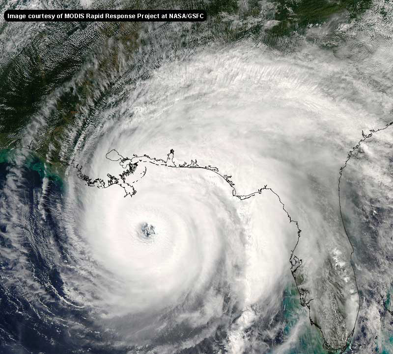
It is expecting landfall pretty much over Panama City in just under 2 days with an intensity just slightly below the official forecase - somewhere around borderline hurricane intensity. No real surprises there.
However, with Charlie, it keeps the storm further offshore than almost every model and, as a consequence, stronger than all but the SHIPS guidance. It brings Charlie up to high-end cat 2 in 96hr with an eventual landfall near Apalachicola (or just slightly east) shortly thereafter. All of the other guidance is further west, clustered towards Cedar Key. But, wait a day or two for the Gulfstream obs - both of the Gulf with Bonnie and the Carib. with Charlie - and see what happens then. There's a little too much run-to-run inconsistency with almost every model for my liking.
Wish recon could've stayed out there a while longer on Charlie to sample around the current flareup, but alas they left right as it started to blossom. It's looking better on the satellite, but it still needs to slow down to intensify at any decent clip. Maybe this flareup suggests it might be doing just that. And Bonnie? I still can't tell if there's a 2nd center forming or not, and we've just lost the daylight & the visible imagery over the region. Expect status quo for another 6hr with this storm as it gets it's act together, then re-evaluate things. The potential is still there...just not yet.
--------------------
Current Tropical Model Output Plots
(or view them on the main page for any active Atlantic storms!)
|
h2ocean
Weather Hobbyist

Reged:
Posts: 91
Loc: South Merritt Island, FL
|
|
I know what you mean...anytime there is a threat here in East-Central FL, everyone waits until the last minute. Apparently there is some sort of "legend" around here that the Cape (Cape Canaveral) keeps storms away from this area. Granted, there has not been a major storm here since the late 1800's (just a few Cat 1 and 2) but that is just luck!
I live in a new subdivision and only 4 out of 112 homes have hurricane shutters (I of course am one out of the 4). The windows used in the houses are rated for 140mph but that is not for impact...so everyone thinks...wow our windows will stand up to 140mph - not!
I selected the heaviest aluminum panels for the doors and windows w/ clear lexan inserts (for weaker storms so I can see outside) and armour screen for may patio.
--------------------
Merritt Island, FL Home Weather Station
|
Arnold Sw.
Unregistered
|
|
Hi All,
I've been living in Orlando, FL since 1988 now and haven't seen much of anything come this way. I am heading out of town Thursday morning through the entire weekend.
I am a little leary about leaving the wife and kiddies at home alone with Charlie hanging around.
I've been monitoring this website for years and would like your opinions. I think I will just have to monitor the situation and make a decision before I leave on Thursday morning.
|
Anonymous
Unregistered
|
|
i just got some data from the NOAA flights.... waiting on radar pics from bonnie!
lookin at a 1330 utcc aug graph/picture bonnie is real compact!!!! information based on ships/flights through storm etc..... some interesting stuff!!!!!
|
danielw
Moderator

Reged:
Posts: 3527
Loc: Hattiesburg,MS (31.3N 89.3W)
|
|
700
WTNT33 KNHC 102336
TCPAT3
BULLETIN
TROPICAL STORM INTERMEDIATE ADVISORY NUMBER 6A
NWS TPC/NATIONAL HURRICANE CENTER MIAMI FL
8 PM AST TUE AUG 10 2004
..CHARLEY STRONGER AS IT MOVES RAPIDLY WEST-NORTHWESTWARD ACROSS
THE CENTRAL CARIBBEAN...
A TROPICAL STORM WARNING REMAINS IN EFFECT FOR THE ENTIRE SOUTHWEST
PENINSULA OF HAITI FROM THE DOMINICAN REPUBLIC BORDER WESTWARD
INCLUDING PORT-AU-PRINCE...AND FOR JAMAICA.
A TROPICAL STORM WATCH REMAINS IN EFFECT FOR THE CAYMAN ISLANDS.
AT 8 PM AST...0000Z......0000Z...THE CENTER OF TROPICAL STORM
CHARLEY WAS LOCATED NEAR LATITUDE 15.7 NORTH... LONGITUDE 71.8
WEST OR ABOUT 365 MILES...590 KM...EAST-SOUTHEAST OF KINGSTON
JAMAICA.
CHARLEY IS MOVING TOWARD THE WEST-NORTHWEST NEAR 26 MPH
..43 KM/HR...AND THIS GENERAL MOTION IS EXPECTED TO CONTINUE FOR
THE NEXT 24 HOURS. ON THIS TRACK THE CENTER OF THE STORM WILL BE
NEARING JAMAICA TOMORROW MORNING.
REPORTS FROM AN AIR FORCE RESERVE HURRICANE HUNTER AIRCRAFT INDICATE
THAT MAXIMUM WINDS ARE NEAR 65 MPH...105 KM/HR...WITH HIGHER
GUSTS...OVER A SMALL AREA JUST NORTHEAST OF THE CENTER. ADDITIONAL
STRENGTHENING IS EXPECTED DURING THE NEXT 24 HOURS.
TROPICAL STORM FORCE WINDS EXTEND OUTWARD UP TO 105 MILES
..165 KM MAINLY TO THE NORTH OF THE CENTER.
THE ESTIMATED MINIMUM CENTRAL PRESSURE IS 999 MB...29.50 INCHES.
Edited by danielw (Tue Aug 10 2004 07:53 PM)
|
Anonymous
Unregistered
|
|
URNT12 KNHC 102304
VORTEX DATA MESSAGE
A. 10/2304Z
B. 24 DEG 43 MIN N
90 DEG 31 MIN W
C. 850 MB 1455 M
D. 25 KT
E. 127 DEG 28 NM
F. 209 DEG 35 KT
G. 130 DEG 015 NM
H. 1004 MB
I. 19 C/ 1526 M
J. 24 C/ 1521 M
K. 17 C/ NA
L. NA
M. NA
N. 12345/8
O. 0.1/3 NM
P. AF977 0502A BONNIE OB 24
MAX FL WIND 35 KT SE QUAD 2259Z.
URNT11 KNHC 102323
97779 23234 30254 89700 15400 15017 17161 /2520 41315
RMK AF977 0502A BONNIE OB 27
URNT11 KNHC 102341
97779 23414 30267 90000 55900 20019 55//1 /4589
RMK AF977 0502A BONNIE OB 28. LAST REPORT
|
Anonymous
Unregistered
|
|
Station 42001 - MID GULF 180 nm South of Southwest Pass, LA
Conditions at 42001 as of
(5:50 pm CDT)
2250 GMT on 08/10/2004:
Wind Direction (WDIR): SE ( 140 deg true )
Wind Speed (WSPD): 15.5 kts
Wind Gust (GST): 19.4 kts
29.89 in
Pressure Tendency (PTDY): -0.10 in ( Falling Rapidly )
|
rickonboat
Weather Hobbyist
Reged:
Posts: 90
|
|
Charley---amazing it is moving at 26 mph, and actually strengthening. if it slows down, we all know what will happen....
Bonnie---
We're getting 50-60 mph winds right now, as I am typing this, in Mobile...with rain coming down like buckets. I wonder if all this energy is messing with Bonnie, and it's ability to grow. I think this energy and Bonnie are on a collision course, and the little tropical storm will soon pop. Interesting that the dry air between Bonnie and the front is getting smaller and smaller. As soon as they mesh, things will get livelier.
been 50-65 mph winds for the last 10 minutes...unbelievable burst of energy over Mobile right now...bad thunderstorms...
|
SirCane
Storm Tracker

Reged:
Posts: 249
Loc: Pensacola, FL
|
|
Quote:
Pressure Tendency (PTDY): -0.10 in ( Falling Rapidly )
Hmmm, possible sign that Bonnie may go through a period of organization and strengthening? 
--------------------
Direct Hits:
Hurricane Erin (1995) 100 mph
Hurricane Opal (1995) 115 mph
Hurricane Ivan (2004) 130 mph
Hurricane Dennis (2005) 120 mph
http://www.hardcoreweather.com
|
Anonymous
Unregistered
|
|
like i said around noon..... night will fall and bonnie is coming back out to play. Only this time it might get nasty. Storms are exploding over center now..... i think we haven't seen the worse yet. Another recon will be on it way to bonnie soon, and i think they will find some interesting stuff tonight! Bonnie appears to be covering her "eye"/center back up with some strong storms
|
danielw
Moderator

Reged:
Posts: 3527
Loc: Hattiesburg,MS (31.3N 89.3W)
|
|
Rickonboat, I believe you are getting the remains of the Bourbon St. low that was in New Orleans yesterday. Moved off slowly to east this AM.
Edited by danielw (Tue Aug 10 2004 08:06 PM)
|
LI Phil
User

Reged:
Posts: 2637
Loc: Long Island (40.7N 73.6W)
|
|
You've been making some excellent posts, so I'm certainly not going to edit you...you might consider joining and/or posting with a handle. Makes it easier to attribute who says what. And, during crazy periods, it may become necessary to "close" the boards to only registered users.
All you have to give is your e-mail address, which is kept completely secret (even I couldn't get it if I wanted to).
Consider it.
--------------------
2005 Forecast: 14/7/4
BUCKLE UP!
"If your topic ain't tropic, your post will be toast"
|
Colleen A.
Moderator

Reged:
Posts: 1432
Loc: Florida
|
|
The new track for didn't get my attention immediately...(I almost fell off my chair), when I read the 5pm Discussion, this did:
Quote:
IF FOLLOWS THE INDICATED TRACK...THE
SPEED MAY VERY WELL BE TOO SLOW BUT THERE IS CONSIDERABLE
UNCERTAINTY IN JUST WHERE THIS SYSTEM WILL END UP IN 3-5 DAYS.
IF THE GUIDANCE FOR THE NEXT PACKAGE IS SIMILAR...THE OFFICIAL TRACK
MAY HAVE BE SHIFTED A LITTLE FARTHER TO THE EAST
.
I'm still waiting for a few more runs but it isn't as if it was just ONE model, it was generally a consensus. I don't think is sick at all, I think he was getting his act together. If he just grazes the eastern part of Cuba, it will have little effect on .
I think we may be looking at a double whammy on Florida in the next few days. West Central Florida can't take much more water and is a big 'un. We'd also get feeder bans from Bonnie, since we'd be on the right side quadrant of that storm.
Also...I think that latest Recon obsveration of higher winds was coming...you don't normally have a storm with 999mb with winds at 40mph. I think it was just that they hadn't sampled all the quadrants at the time the 5pm advisory was issued. Which is why we have Advisory 6A.
Be prepared, stay calm, and pay attention. I think this might be the first time we can't keep hitting the "snooze button" on the alarm clock.
--------------------
You know you're a hurricane freak when you wake up in the morning and hit "REFRESH" on CFHC instead of the Snooze Button.
|
HanKFranK
User

Reged:
Posts: 1841
Loc: Graniteville, SC
|
|
ran across the board today, saw lots of flip-flopping with transient trends (charley is dying, bonnie is strengthening rapidly, etc). wish i could be more concrete here.. but unfortunately, still going to give possibilities and not a specific prediction i'm confident in of on bonnie.. feel just as good or better about ; bonnie we'll be seeing from first, so here goes.
bonnie is essentially the same storm we had last night. it's small and only throwing spotty deep convection despite a good shear profile.. subsidence abounds in the gulf. i see the possibility that it remains nearly steady or only slowly strengthens, but am entertaining the idea that it will be rapidly intensifying at landfall... for this reason:
bonnie will be traveling ahead of an upper shortwave a'la alex.. over a much higher ocean heat content. the environment will be baroclinic as well.. i'd expect it to stay fairly potent well after landfall as it moves up the east coast. with the very small inner structure the potential for this system to deepen rapidly is a real and present danger. if it can't keep the convection going, though.. it may come ashore as a sickly system like one i remember from 2000.. helene.. or maybe something akin to barry 2001.
charley.. God forbid it forms an eye overnight. i've been erring on the side of strengthening, thus erring on the side of a rightward of the early globals track.. looks like my dice throw will be coming up strong. is getting stronger earlier.. and thus the official numbers are likely below what we'll be seeing. there is still great uncertainty, but has 'major hurricane event' written all over it. if i was on the gulf side of florida i'd be planning ways to deal with either.
frontal low moving ene between bermuda and JAX slowly improving in presentation.. several globals occlude it and weaken the westerlies as a high amplitude ridge develops in response to the approaching eastern shortwave.. may pancake against it and develop tropical characteristics later this week.
as the mean trough position is forecast to shift out of the east next week, pay close heed to wave action in the mdr east of the islands. there is a lazy, dead look to the easterly flow and low shear.. trouble if a wave of any amplitude comes through. even a weak wave can perk up in these conditions.. the upper low near 45-50w should start tailing back and creating a diffluence/ridging zone to its east.. so watch for a response 5-10 deg to it's east over the next few.
possibility for two florida hurricane landfalls exists for the next few days. the ingredients are there, but ingredients have a way of not panning out. regardless, stay aware.
HF 0011z11august
Edited by HanKFranK (Tue Aug 10 2004 08:15 PM)
|
mikeG
Unregistered
|
|
12 hrs ago, based on NOAA data, bonnie was a one sided storm. hint the kidney bean structure seen this morning on sat shots. most of TS wind were less than 35 miles front center, mostly on NE and SE quad.
observed surface wind was 51 kts wnds were observed at 1114utc....at 3 nm NE of center....(via GPSSONDE drop)
analyzed max surface winds 50 kts 6 nm NE of center
NOTE *** THIS IS EXPERIMENTAL RESEARCH
|
DroopGB31
Weather Guru
Reged:
Posts: 122
Loc: Pensacola
|
|
Any guess where the watches for Bonnie go up? Mobile to Cedar Key? Im hoping, I need to get out of school tomorrow so I can stay here and track Bonnie with ya'll. By the way, Saw ole George Bush today while at school. Very neat.
|


 Threaded


