ticka1
Weather Hobbyist
Reged:
Posts: 54
Loc: Southeast Texas
|
|
Has 's forward motion slowed down any? I think even if he is now south of the forecasted track he will eventually be pulled northward and towards Florida.
I just hope folks prepare and heed the warnings.
--------------------
Join www.wildonweather.com/forum Message Board
|
Kevin
Weather Master

Reged:
Posts: 524
Loc: EC Florida
|
|
I'm going to throw out a couple of reasons as to why I (IMO) think is moving a little more westerly at this time. Naturally, I'm going to show you all a steering currents map:
http://cimss.ssec.wisc.edu/tropic/real-time/atlantic/winds/archive/wg8dlm1-2.html
This image of the steering current map shows that 6 hours ago the ridge anchored in the Western Atlantic was extending towards 90 west. Naturally, was moving wnw.
3 hours ago the ridge actually seemed to flatten out somewhat, causing a more westerly steering current.
http://cimss.ssec.wisc.edu/tropic/real-time/atlantic/winds/wg8dlm2.html
The most recent map that may be caught up in a more east to west steering flow, but with the way these patterns change, 's more westerly movement probably won't last for a long time.
Oh and btw...does anyone here seem to think that 's 5 AM track was too far south? Their track from 11:00 PM last night may turn out to be more accurate.
Another reason for 's more westerly movement could possibly be the formation of an eye. This MIGHT be causing to wobble a little.
On another note, more time over water and less interaction with Cuba could mean a stronger storm. I still expect to hit Florida's west coast, with Tampa northward at a higher risk for a direct landfall.
|
Kevin
Weather Master

Reged:
Posts: 524
Loc: EC Florida
|
|
"Constant motion not fluxuations.
We are in for the long haul."-Bobbi
Can't the stress the importance of this enough. I believe that uses satellite fixes that are several hours in length before determining motion.
When making a forecast, biting too hard on what could turn out to be a short-term trend can ruin your forecast. With that being said, the new models have shifted to the west, now indicating more of a northern FP landfall.
|
rmbjoe1954
Weather Master
Reged:
Posts: 428
Loc: Port Saint Lucie, Florida, USA
|
|
These discussions are great, but to be effective, you must disclose the name of the storm you are talking about.
Thnak you.
--------------------
________2024 Forecast: 24/14/7________
There is little chance that meteorologists can solve the mysteries of weather until they gain an understanding of the mutual attraction of rain and weekends. ~Arnot Sheppard
|
Kevin
Weather Master

Reged:
Posts: 524
Loc: EC Florida
|
|
HAHAHAHAHA, thanks Joe! 
I was talking about . 
|
Steve hirschb.
Unregistered
|
|
Need to correct myself here for the record. That SW eye 'o is false. Taske a good look at the loop. The circulation center is north of that, as you can see the convection wrapping around the center. It's trying to wrap tight and gives the appearance of an eye, when its actually to the SW of the center. Its still heading wnw and will begin its turn to the NW tomorrow. Its on track. Unfortunately, Radvak may be right. It has had no interaction with land, and when the trough begins to affect it, it have more time over the hot GOM.
|
Kevin
Weather Master

Reged:
Posts: 524
Loc: EC Florida
|
|
Look at latest vis loop of :
http://www.ssd.noaa.gov/PS/TROP/DATA/RT/float2-vis-loop.html
It looks to me like 's rather cloudy eye is "jumping" back towards Jamaica again. Turning the zoom feature on will help illustrate what I am saying.
|
LI Phil
User

Reged:
Posts: 2637
Loc: Long Island (40.7N 73.6W)
|
|
models
--------------------
2005 Forecast: 14/7/4
BUCKLE UP!
"If your topic ain't tropic, your post will be toast"
|
alan
Unregistered
|
|
http://intellicast.com/Local/USNationalW...ne&pid=none
|
jth
Storm Tracker
Reged:
Posts: 275
|
|
Will shift track west at 5???? I think so. The new models are more reliable as they initialized in the correct area and had more data from recon flights.
|
Kevin
Weather Master

Reged:
Posts: 524
Loc: EC Florida
|
|
Agree, although this should average out to a wnw motion when you consider the more westerly tracking that occured earlier.
|
SirCane
Storm Tracker

Reged:
Posts: 249
Loc: Pensacola, FL
|
|
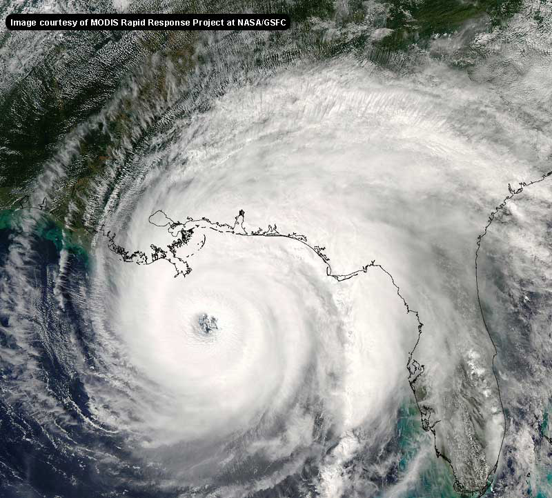
Here's an awesome shot of Bonnie....
Bonnie
As for , looks like the models shifted to the left.
|
rickonboat
Weather Hobbyist
Reged:
Posts: 90
|
|
Bonnie is taking a more classic shape to me. She might suprise us...moving at just the right speed....some hapless folks east of me may catch a category 2 on the chin.
hope nobody falls asleep with her...looking over her shoulder at Charlie...
|
tornado00
Weather Hobbyist
Reged:
Posts: 85
Loc: Maitland, Florida, USA
|
|
Well it seems even if Charlie varies a little, it will strike in the general area of Tampa Bay. Which means that 's center will pass right over my house. Think its going to be a little windy, especially since going to be in the northeast quadrant. Think it's time to batten down the hatches. 
--------------------
Derek Sutherland
|
Lake Toho - Kissimmee
Storm Tracker

Reged:
Posts: 317
Loc: Kissimmee, Florida on Lake Toh...
|
|
Those models appear to be compiled at 10:30 AM this morning. Though it says UCT not UTC so I am not sure if there is another time zone that I am not aware of ?
--------------------
Dream like you will live forever.. Live like there is no tommorow.. Darwin Rules !!
|
jth
Storm Tracker
Reged:
Posts: 275
|
|
Can someone please tell us what Joe B's most recent take is.
|
jth
Storm Tracker
Reged:
Posts: 275
|
|
Yeah those are from earlier, and they already shifted west prior to the more westerly track. I think they all may shift further west on the next run. That said, Charles does seem to be moving more WNW now.
|
Anonymous
Unregistered
|
|
I think they wrote it in Central Standard Time this morning.
|
Anonymous
Unregistered
|
|
Guys I don't see the trend westward happening. I could be wrong, buI think the s track is fairly close.
|
LI Phil
User

Reged:
Posts: 2637
Loc: Long Island (40.7N 73.6W)
|
|
DATE/TIME LAT LON CLASSIFICATION STORM
11/1745 UTC 16.6N 76.7W T4.0/4.0
11/1745 UTC 26.1N 89.6W T3.0/3.0 BONNIE
--------------------
2005 Forecast: 14/7/4
BUCKLE UP!
"If your topic ain't tropic, your post will be toast"
|


 Threaded


