MikeC
Admin
Reged:
Posts: 4695
Loc: Orlando, FL
|
|
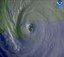
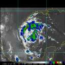
Frances, still a Category 3 storm, will fluctuate in intensity again, and may get a bit stronger a little bit before landfall likely sometime tomorrow afternoon. The biggest story, however, is that it will move slowly over the peninsula.
Good luck tomorrow all, prayers, and more to all my friends in Florida. I am out for the evening -- flying to atlanta tonight. Others will fill the gap tonight.
Hurricane Local Statements for Weather Offices in:
Melbourne (East Central Florida) - Long Range Radar Loop
Miami (South Florida) - Long Range Radar Loop
Key West (Florida Keys)Long Range Radar Loop
Tampa Bay (West Central Florida)Long Range Radar Loop
[url=http://flhurricane.com/cyclone/wxstatement.php?t=HLS&l=JAX]
Jacksonville (North Florida)[/url] - Long Range Radar Loop
Local county by county information will no longer be updated unles there is breaking news here -- it's just impossible to keep up because of the size of the area under Hurricane Watch. Use the links in the last article to view county emergency management webpages. Florida Disaster.org is the state em page, with links to locals as well.
Definitely more to come later...
** SITE NOTE ** This website is receiving way beyond record traffic today, it will be slow, it will go down ocasionally, but should be back up shortly when that happens. We've done everything we can to help this along short of dumping zillions into bandwidth and hardware to keep it going. Apologies in advance.
Jim Williams over at Hurricane City will be doing live broadcasts about Hurricane startiing tonight at 8PM EST.
Event RelatedLinks
Miami Radar Long Range loop (Note the Miami NWS Radar hardware is having issues and may be down)
Frances Models -- This image animated over time
TD#9 Models -- This image animated over time
All model "Spaghetti" for from hurricanealley
The Caribbean Hurricane Page - updates from the islands
Caribbean Island Weather Reports
Nice color satellite image of approach (Animated Version)
High Speed Satellite Loops of (Click floater)
General Links
Current Aircraft Recon Info
NRL Monterey Marine Meteorology Division Forecast Track of Active Systems (Good Forecast Track Graphic and Satellite Photos)
Check the Storm Forum from time to time for comments on any new developing system.
Follow worldwide SST evolution here:
Global SST Animation
NASA GHCC Interactive Satellite images at:
North Atlantic Visible (Daytime Only), Infrared, Water Vapor
LSU Sat images
Some forecast models:
NGM, AVN, MRF, ETA ECMWF
AVN, , , JMA, , UKMET
DoD Weather Models (NOGAPS, AVN, MRF)
Multi-model plots from WREL
Other commentary at Independentwx.com, Robert Lightbown/Crown Weather Tropical Update Accuweather's Joe Bastardi (now subcriber only unfortunately), Hurricane Alley North Atlantic Page, HurricaneVille, Cyclomax (Rich B.), Hurricane City , mpittweather , WXRisk, Gary Gray's Millennium Weather, storm2k, Barometer Bob's Hurricane Hollow, Snonut,
Even more on the links page.
|
WeatherNLU
Meteorologist

Reged:
Posts: 212
Loc: New Orleans, LA
|
|
Mike, just an FYI, you may want to stop using that Hurricane Alley "Spaghetti Run" model map. They went PPV and that model run is from nearly two days ago.
--------------------
I survived Hurricane Katrina, but nothing I owned did!
|
SoonerShawn
Unregistered
|
|
Looking at the Miami radar I can see a definite w to wnw motion. The eye (center) is starting to come into view on it now.
ShawnS
|
eligrace
Unregistered
|
|
Jason or anyone else could you tell me a site as to where i could get a windfield map ,for the current forecasted track.
|
Colleen A.
Moderator

Reged:
Posts: 1432
Loc: Florida
|
|
Okay, that met just answered all my questions. Either right in at Vero Beach, or just south of it around 5pm tomorrow night with winds 120+ plus...he was also using a model (the ?) and he pointed out this model they were using at his weather center was now coming into line with the 'S forecast track now, no longer indicating a northwest/brush along the coast. He also said (and this is what he said, not ME) that is it is POSSIBILE that this storm could re-intensify to a CAT IV before making landfall.
I'm not saying this to scare anyone or be an alarmist, I'm just telling you what he said. So don't anyone yell at me, okay? 
--------------------
You know you're a hurricane freak when you wake up in the morning and hit "REFRESH" on CFHC instead of the Snooze Button.
|
Frank P
Veteran Storm Chaser
Reged:
Posts: 1299
|
|
looking at the Miami radar gives a weird presentation of the eye... yeah, front eye wall part of it looks to be moving west, not sure what the east eye wall is doing, its like hanging behind, thus the radar presentation hints that the eye is perhaps elongating from WNW to ESE.... I would think you would really see a much better developed eye on radar with a storm this strong...
No one yell at Colleen either... 
|
Frank P
Veteran Storm Chaser
Reged:
Posts: 1299
|
|
Presure up, winds down...
Storm : Observed By AF #984
Storm #06 in Atlantic Ocean
Date/Time of Recon Report: Friday, September 03, 2004 16:09:00
Position of the center: 25° 52' N 77° 16' W
Minimum Height Measured At Standard Level Of 700mb: 2748m (Normal: 3011)
Maximum Surface Winds Were: Not Estimated
No Bearing From Center To Estimated Surface Winds Was Measured
Maximum Flight Level Winds Were 90KT (103.5mph) From 136°
Maximum Flight Level Winds Were Measured 046nm (52.9miles) From Center At Bearing 034°
Minimum pressure: 960mb (28.35in)
Eye Wall Was < 50% Closed
Eye Did Not Have A Definable Form
Center Fix Established Using: Penetration Wind Pressure Temperature
Center Fix Established At Level(s): 700mb
Navigational Accuracy Measured At 0.1nm
Meteorological Accuracy Measured At 1nm
|
Kimmie
Registered User
Reged:
Posts: 5
Loc: Lousiana
|
|
I noticed the same thing with the radar out of Miami. Looks to be heading WNW at this moment and now that it is within radar range we will be able to track her right into landfall. Doesn't seem possible that it would be moving as slow as they say??? I pray for Florida's sake she decides to become a fast mover! Hope everyone is where they need to be and SAFE! Kimmie
|
Frank P
Veteran Storm Chaser
Reged:
Posts: 1299
|
|
provided by Londovir and his programming skills....
thanks Londovir....
Per the recon vortex message the eye did not have a definable form.... gee maybe that is why I'm having so much trouble trying to get it on radar....
Edited by Frank P (Fri Sep 03 2004 05:55 PM)
|
RevUp
Weather Guru
Reged:
Posts: 181
Loc:
|
|
fyi - model spaghetti from "hurricane alley" is not updating anymore ... by paid subscription only now. Thanks Mike for keeping this board going! Maybe we'll hear from you in ATL.
|
SkeetoBite
Master of Maps

Reged:
Posts: 298
Loc: Lakeland, FL
|
|
Quote:
Jason or anyone else could you tell me a site as to where i could get a windfield map ,for the current forecasted track.
In progess... when done these maps will be avaiable at http://www.skeetobite.com
Busy locking down a home and a business... yikes - a CAT 1 over Lakeland, FL. Who would have guessed?
|
Ronn
User

Reged:
Posts: 115
Loc: Seminole, FL
|
|
The wind field of has become considerably larger over the past 6 hours. I think is going to have a difficult time wrapping up and becoming better organized before landfall. In my opinion, the intensity has leveled off and will remain between 95-105 knots until landfall.
Ronn
Edited by Ronn (Fri Sep 03 2004 05:55 PM)
|
Alberta Canada
Unregistered
|
|
Thoughts are with you Florida....batton down and hang on!
|
teal61
Weather Hobbyist
Reged:
Posts: 61
Loc: Spring, TX (30.1N 95.5W)
|
|
After looking at the Miami radar loop and the rapid scan sat loop I've come to the conclusion that she's stationary right off of the southern point if that island (don't remember the name of it). If you look at the composite reflectivity long range loop you can pick up some lighter returns moving east around the center and it looks to be just south or southeast of the islands southern point. There may be some movement off to the west northwest but it is very slow.
Upon further review, I am fairly confident that is the center, but I now believe it's over or just east of the southern part of the island. Again, the composite reflectivity loop shows this very well especially when it's run at a faster speed. Hard to tell about movement maybe very slowly wnw, but I think its nearly stationary and the last two recon fixes would seem to confirm that. If this is the center it's about 30 miles or so east of the 's 5pm position.
Edited by teal61 (Fri Sep 03 2004 06:22 PM)
|
SoonerShawn
Unregistered
|
|
You can easily see the eyewall opening up on the west side in the latest visible. So much for the weakening being over.
ShawnS
|
schmoo
Unregistered
|
|
is another more northerly shift expected?
I'm confused by the direction it appears to be going and the projected landfall.
|
AgentB
Weather Guru

Reged:
Posts: 188
Loc: Winter Park, FL
|
|
Remember this stall is not unexpected. Unfortunately some had it stalling a bit further north, and some right where it is. The next forecasted motion that was supposed to take place after this stall was a movement just north of west. I believe the storm has felt it's way into the ridge, and now it will feel it's way along a "path of least resistance". That is supposed to be to the WNW, but anything can happen. Also, the storm has seemed to trend further south than each forecast had it at. With that in mind I still see it making landfall around WPB and tracking just north of west across the state.
--------------------
Check the Surf
|
SkeetoBite
Master of Maps

Reged:
Posts: 298
Loc: Lakeland, FL
|
|
Closer, more detailed tracking map available here:
http://www.skeetobite.com
Wind field map in progress - it's getting so big we can barely map it and display a reduced size image. Guess they'll just get bigger too!
|
RevUp
Weather Guru
Reged:
Posts: 181
Loc:
|
|
Here's a link to some realtime rainfall data from South Florida Water Management District Useful for the next 24 hours at least. Shows about 0.50 inches of rain along Palm Beach coast this afternoon. Nothing compared with what Eleuthera and Abaco islands have been getting, and what's in store for parts of Florida! is staying on track with .
--------------------
"Let tomorrow worry about itself. Each day has enough trouble of its own."
|
erauwx
Verified CFHC User

Reged:
Posts: 15
Loc: Orlando, FL
|
|
Definite burst in convective activity (on IR) ... anybody else notice?? Am I seeing things?
|


 Threaded


