Lysis
User

Reged:
Posts: 451
Loc: Hong Kong
|
|
Nice! I can't wait until next season (well, sorta). This will be my first as a member of this board.
Looked like had hit just the day before.
Dude, you have no idea. Most of the houses here still don't have roof shingles.
By November we were mostly cleaned up. Of course it will be several years before all visual indications (save the new barrier islands forged by ) are virtually gone. Even then it will never be as it once was. Port Charlotte still looks like crap, especially along 41 just coming out of PG. In Punta Gorda Isles, where I live, image is very important (although I highly doubt we will ever get "best place to live in America" again), so we cleaned up pretty quick. For a good little display of how tornadic the devastation was, take a look at my short movie entitled “Respect the Wind”, featuring the Van Halen song by the same name.
--------------------
cheers
Edited by Lysis (Sat Mar 26 2005 07:38 PM)
|
LI Phil
User

Reged:
Posts: 2637
Loc: Long Island (40.7N 73.6W)
|
|
I want to personally "vouch" for Lysis (aka Jeff) and his videos...they are amazing...Respect the Wind takes on a new meaning when you have someone in the eye and filming...
I also want to pump up "skeet" and his maps...he's being modest...
Although I don't want 2004 to repeat itself or even be a mere shadow of itself, IF it does happen...
CFHC will be the place to be for your maps, storm surge measures, evac plans, shelter info, etc...
If you need us, we'll be there... 
--------------------
2005 Forecast: 14/7/4
BUCKLE UP!
"If your topic ain't tropic, your post will be toast"
|
danielw
Moderator

Reged:
Posts: 3526
Loc: Hattiesburg,MS (31.3N 89.3W)
|
|
Quote:
I also want to pump up "skeet" and his maps...he's being modest...
Although I don't want 2004 to repeat itself or even be a mere shadow of itself, IF it does happen...
CFHC will be the place to be for your maps, storm surge measures, evac plans, shelter info, etc...
If you need us, we'll be there...
Geez, Phil...That's a sound byte in the broadcast business. That could be a new trademark...better send it up the ladder.
That said. Phil summed it up. Skeet's maps 'Rock'. And you won't find a more modest Marine anywhere! There may be some information that doesn't get posted on during Hurricane Season. I can't think of what it would be, and if you'll post or PM us, we'll try to fill that gap.
I don't understand why /TPC decided not to change their maps. I saw an article that stated they received over 900 replies to their 'request for changes'. Most of the replies were along the line..."if it isn't broke, don't fix it". I'll agree with that, but you can fine tune the machine, and get more info out of it. Maybe we won't have to use the maps this year, Maybe.
|
~Floydbuster
Verified CFHC User
Reged:
Posts: 16
|
|
Some are trying to upgrade it to a Cat 5. They are saying a 173 mph gust in Punta Gorda, and a 180 mph gust at Charlotte County Medical Center should make it a Cat 5.
Well, hit the area around Charlotte County Medical Center at 150 mph...so gusts up to 180 mph are expected.
It then hit Punta Gorda at 145 mph, so gusts to 175 mph are expected, therefore, a 173 mph gust makes sense.
By the way...there was 6 mph difference. was not 155 mph, it was 150 mph.
|
HanKFranK
User

Reged:
Posts: 1841
Loc: Graniteville, SC
|
|
this may not be a very popular view, since it differs quite a bit from the others on this thread.. but i don't think the spot winds at your place were quite what some are saying. from the video i'd estimate the highest winds being filmed are around 115/120 mph sustained... briefly. they probably did peak at around 135 mph at some point in the eyewall--keep in mind the highest winds recorded in a storm generally apply to winds over the ocean. friction from land really causes winds to drop off quickly, even in a fast-mover like . they probably did peak around 145 right against the harbor. it's sort of a tricky thing anyway--with strong, intensifying systems you get eyewall mesocyclones that work sort of like large F2/F3 tornadoes, causing an irregular damage pattern. at localities it really is a random thing. hydraulic forcing from features such as buildings and standing foliage (e.g., the wind accelerating between buildings) cause local-scale differences in the wind speed.
anyway, all that said, i mean to take nothing away from what you experienced. a lot of guys wouldn't have had the nerve you did to keep filming and not let fear overwhelm them. jeff, maybe when you get bored with hurricanes you can follow the grunts into combat.
later y'all.
HF 0630z27march
|
~Floydbuster
Verified CFHC User
Reged:
Posts: 16
|
|
Based on the damage near the end of the film, they DEFINITLEY recived Category 4 sustained winds of ATLEAST 140 mph, IMO.
|
HanKFranK
User
Reged:
Posts: 1841
Loc: Graniteville, SC
|
|
you could be right about the peak. was compact and fast-moving... the kind of damage usually associated with such high winds didn't occur for as long as would typically be the case with a landfalling 4. if you check the damage parameters for a 4 on the saffir-simpson, much of what you see in the film is in the 3-4 range.. spots of 4, generally 3... there isn't the degree of widespread structural failure you'd expect typical to cat 4 winds. localized SFC friction variability, hydraulic channeling, or eyewall mesos are the only explanations i can think up for what you see on the ride-around video. depending on whether you're using 1 min, 2 min, or 10 min sustained winds, or the exact elevation of the anemometer and location in relation to surface features.. there can be several mph worth of variation in readings. to be honest i'm not even sure which the considers to be the actual true measurement. but anyway you can get your answers or mine depending on what criteria you use. we can fuss about it all day, 'cause i don't know any engineers who can come and verify our reasoning. they'd all probably get slightly different answers too, anyhow.
HF 1902z27march
|
danielw
Moderator
Reged:
Posts: 3526
Loc: Hattiesburg,MS (31.3N 89.3W)
|
|
I haven't looked at the video yet. Hank presents every angle of wind speed definition that I'm aware of. Different elevations, buildings and trees above ground. I remember Jim Cantore and Stephanie Abrams being blown around while doing their live shots.
The late Dr Fujita had developed a combination scale between the Fujita Scale and the Saffir-Simpson Scale. You could probably find it with a search engine. Basically interpolates the two scale and the visual damage differences.
http://www.friesian.com/wind.htm
http://www.ncdc.noaa.gov/oa/satellite/satelliteseye/educational/saffir.html
Seems I recall reading about the mesocyclonic circulations around 's eye. I guess a simple comparision would be a large multiple vortex tornado. Many different directions and wind speeds in a small area.
I'll have to watch the video. Now!
Edited by danielw (Mon Mar 28 2005 12:02 AM)
|
Katie
Weather Guru

Reged:
Posts: 167
Loc: Winter Haven, FL
|
|
Lysis as I have told you before, I think the video is great. You did a great job and I want a copy. I still need to find out how I can get you my footage from Polk County. It wasn't as bad as it was down your way but what I did get just shows how strong he still was by the time he hit us.
Skeet - I have emailed you personally before also to tell you how great your maps are! Seriously, awesome. Keep up the great job! I look forward to seeing more this season.
Katie
|
Lysis
User
Reged:
Posts: 451
Loc: Hong Kong
|
|
this may not be a very popular view, since it differs quite a bit from the others on this thread.. but i don't think the spot winds at your place were quite what some are saying. from the video i'd estimate the highest winds being filmed are around 115/120 mph sustained... briefly. they probably did peak at around 135 mph at some point in the eyewall--keep in mind the highest winds recorded in a storm generally apply to winds over the ocean. friction from land really causes winds to drop off quickly, even in a fast-mover like . they probably did peak around 145 right against the harbor. it's sort of a tricky thing anyway--with strong, intensifying systems you get eyewall mesocyclones that work sort of like large F2/F3 tornadoes, causing an irregular damage pattern. at localities it really is a random thing. hydraulic forcing from features such as buildings and standing foliage (e.g., the wind accelerating between buildings) cause local-scale differences in the wind speed.
anyway, all that said, i mean to take nothing away from what you experienced. a lot of guys wouldn't have had the nerve you did to keep filming and not let fear overwhelm them. jeff, maybe when you get bored with hurricanes you can follow the grunts into combat.
later y'all.
HF 0630z27march
Naturally, I will tend to agree with those favoring a more intense storm. I will try to stay open in this respect though. When considering winds you must realize that I stopped filming outside well before the eyewall, and my visual record in no way indicates the storms peak wind speed.
All things considered, I believe (granted with a bias) that 115 to 130mph is just too low of a figure.
there isn't the degree of widespread structural failure you'd expect typical to cat 4 winds.
Hurricane force winds only extended 25 miles from the center of the cyclone. As such, the destruction, while extreme (and it was) is naturally going to be tornadic in profile, covering only a small area. To drive through the area is pretty incredible. You have extreme damage throughout Punta Gorda Isles wich borders the harbor, stopping just outside of downtown, and extending to a thin section of commercial structures bordering 41. Literally, five minutes of driving decreases the level of damage dramatically. While I am no damage expert, this looks pretty extreme to me:
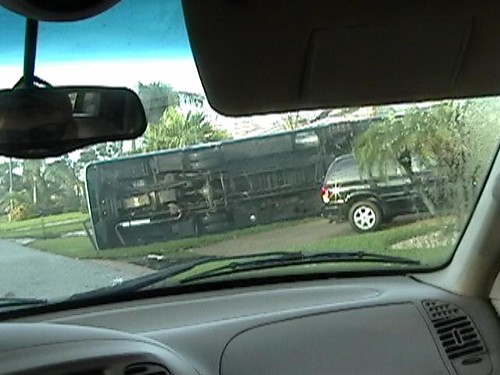
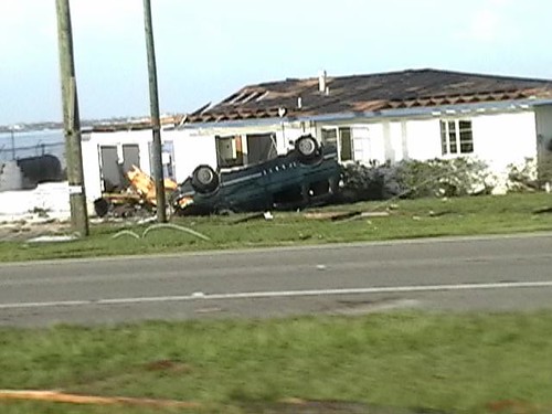

You must also remember, building codes here are quite strict (150 mph I believe) and your analysis on wind speed in correlation to structural damage must take this into consideration.
You just didn’t see damage like that of my ending montage with or Jeanne.
jeff, maybe when you get bored with hurricanes you can follow the grunts into combat
Hmmm… sounds fun. 
Edited by Lysis (Tue Mar 29 2005 09:50 PM)
|
Lysis
User
Reged:
Posts: 451
Loc: Hong Kong
|
|
Here is a little something I just made for perspective (white dot = our house)

Edited by Lysis (Fri Apr 01 2005 01:50 PM)
|
hurricane_run
Storm Tracker

Reged:
Posts: 366
Loc: USA
|
|
nice and great documentary
|
Clark
Meteorologist
Reged:
Posts: 1710
Loc:
|
|
HF - uses 1 minute averaged winds for their maximum wind reports. The uses 10 minute averaged winds for theirs out in the WPacific; that makes some of those storms even more impressive. Most other agencies use 2, 5, or 10 minute averages.
I think some of the reason why the didn't change the track maps, beyond the education issue noted in another thread, is that none of their proposed alternatives were all that appealing. They simply don't provide the information that is necessary if a change is going to be made to the graphic. GIS technology is getting advanced enough -- think 's work -- to the point that the should strongly consider using it in their applications. The NWS is testing it out with radar imagery, with impressive results. Maybe in future years we'll see a movement towards that, but the proposed alternatives weren't very good (at least IMO) this time around.
Regarding damage & wind speeds with -- there is a lot of uncertainty when it comes to estimating intensity with regards to damage observations. Mesoscale (small scale) features are going to result in wide variations in damage over small areas, especially in a storm the size of . Tornado intensities are only measured by the amount of damage they cause; if a strong tornado touched down and didn't hit anything, it may only be rated an F0 or F1 when, in fact, it was much stronger. Similarly, something of F2 intensity that levels everything in its path may be rated an F3 by one observer and an F4 by another.
While the damage estimators are trained in the field, it is really a very subjective process; two people can come up with vastly different estimates and still not be right. Trying to use these estimates when looking at hurricane damage is going to result in the same uncertainty. Thus, I feel it's better to take the "truth" observations from what instruments were available as the closest thing to being accurate, all while keeping the caveat in there that the true intensity of the storm may not have been accurately sampled by the available tools.
With a storm of 's size, the mathematics show a very rapid drop off in intensity as you move away from the center of a storm; just barely missing the strongest winds may result in you receiving winds 10-15mph less than the maximum observed. Regarding gusts within a storm -- while the nature of a tropical cyclone tends to supress convective downbursts, once the storm has moved on land, this tendency erodes (due to friction and a lack of moist inflow), allowing for the strongest winds associated with the storm (found about 1km up at the top of the boundary layer) to be transferred to the surface as gusts within downdrafts. Slightly stronger gusts may be found a bit further inland from the coast as this tendency erodes; a 170mph gust is not out of the question for a storm of 's intensity a few miles inland.
I don't think anyone's really off base here, just that there's a lot of uncertainty in taking video observations to assess wind speeds with a storm.
--------------------
Current Tropical Model Output Plots
(or view them on the main page for any active Atlantic storms!)
|
Lysis
User
Reged:
Posts: 451
Loc: Hong Kong
|
|
Thanks for the (as usual) great post Clark. I agree that a serious grain of salt should be taken with such matters --specifically considering the existence of mesocyclones, tornadic activity, etc. in such a small storm like . However, when having the right front quadrant/eye of any given storm rotating right over you, what does the size of said storm matter? Not to undermine your very important point concerning incredulous wind speed measurements.... but what is your estimate? Not so much on what I taped, but more so with what happened at the cyclones peak in my area.
--------------------
cheers
Edited by Lysis (Mon Apr 04 2005 05:43 PM)
|
~Floydbuster
Verified CFHC User
Reged:
Posts: 16
|
|
Also remember, Lysis, you (PUNTA GORDA) were in the weaker part of the eyewall, as seen in the attached image:::
|
Lysis
User
Reged:
Posts: 451
Loc: Hong Kong
|
|
Remember, was moving at an oblique angle, so it was Punta Gorda, not Port Charlotte that got the right front quadrant. I go into Port Charlotte every day, and know the area well. Save for a few miles to the north east up 41, Port Charlotte is not nearly as messed up as Punta Gorda. Granted, it was still bad, but not nearly as devastated as downtown Punta Gorda, and Punta Gorda Isles (where I live). Black dot = PGI:

--------------------
cheers
Edited by Lysis (Wed Apr 06 2005 04:12 PM)
|
Lysis
User
Reged:
Posts: 451
Loc: Hong Kong
|
|
I hope the recent downtime had nothing to do with my movie. 
--------------------
cheers
|
HanKFranK
User
Reged:
Posts: 1841
Loc: Graniteville, SC
|
|
Naw man, it was a hosting issue.
Knowing specificially where you are doesn't change my thought on the intensity, but you were in the right quadrant of the storm.
I keep watching that video, showing it to folks. It's quite a bit more than I remember from my inland Hugo and Opal experiences. To be honest, I'm a little bothered by how much it fascinates me.
Make more videos, man. I want you to crash to the site if we can get some.
HF 0039z14april
|
Lysis
User
Reged:
Posts: 451
Loc: Hong Kong
|
|
Make more videos, man. I want you to crash to the site if we can get some.
Heh, thanks for the feedback (Phil diddn't give you any lip did he?) and be sure to show it to as many people as you can. I have received enough positive feedback here in PG that I have started selling a dvd version of my film locally. Perhaps I could begin an online venture. I am very critical of myself, so (intensity aside) I am a bit concerned that my movie may not be any good. With the money I get (that is, assuming I get any), my ultimate goal is to by an HD camera and be the first person in history to film a hurricane in High Definition. We have good friends in both West Palm Beach and Miami. One of the things which I liked about my film was the fact that I was in my own home. I am worried that if I go chasing after a storm I will loose this appeal. I think a movie while at my friends house retain this, as we would be there to help as well. Either way, while I don’t wish a storm on this community or any other, if one hits in South FL, I will be there to film it.
--------------------
cheers
Edited by Lysis (Thu Apr 14 2005 04:01 PM)
|
MikeC
Admin
Reged:
Posts: 4614
Loc: Orlando, FL
|
|
The video serveri is down right now, should get it back up sometime during the week.
|


 Threaded


