MikeC
Admin
Reged:
Posts: 4677
Loc: Orlando, FL
|
|
Tropical Depression One has formed into Tropical Storm this morning. It's movement is toward the north. Folks along the Eastern and Central Gulf coasts will want to watch this one. Tropical Storm watches and Warnings are out for the western
tip of Cuba as well. Not much strengthening is expected. , I'd venture to guess, will remain a Tropical Storm. Still we must watch it.
More to come...
Track map

County zoom

Model Initialization points

Event Related Links
Animated model plots for
Caribbean Island Weather Reports
|
lonny307
Unregistered
|
|
It looks right now that rain and flooding is going to be the main factor. Here in S Fl we don't need anymore rain but the way it looks is more with possible flooding. The stronger gets I would think the less rain here in S.Fl because alot of the deep convection would rap around the center. Hopefully not too much rain here. Will have to wait and see. 
|
Rich B
British Meteorologist
Reged:
Posts: 498
Loc: Gloucestershire, England, UK
|
|
Arlene looks set to be quite a rain maker - especially for areas east of where the centre tracks! Convection in the eastern semi-circle is pretty impressive, but in the western semi-circle it is all but non-existent. I think will remain a pretty one sided storm throughout, with little in the way of convection making it on the west side. Still reckon it will cross Cuba as a 50 mph TS tonight, and then track north in the GOM. I also still think we are looking at a landfall near or just east of Mobile, AL, as a strong TS on the weekend.
--------------------
Rich B
SkyWarn UK
|
mbfly
Weather Guru

Reged:
Posts: 119
Loc: Mobile, Alabama
|
|
Quote:
I also still think we are looking at a landfall near or just east of Mobile, AL, as a strong TS on the weekend.
From the looks of the very nice county map, it looks like it may go right through my backyard.  I'm sure glad it's not another ! Like Rickonaboatinmobile, I don't get really panicky for a TS but I'm still keeping a wary eye on this one thinking it may actually make it up to cat 1. Maybe this one will be ours and just get it over with for the rest of the season (I hope !!) I'm sure glad it's not another ! Like Rickonaboatinmobile, I don't get really panicky for a TS but I'm still keeping a wary eye on this one thinking it may actually make it up to cat 1. Maybe this one will be ours and just get it over with for the rest of the season (I hope !!)
|
Liz
Weather Watcher

Reged:
Posts: 32
Loc: Daytona Beach, Florida
|
|
The met on Fox 35 this morning, stated that he projects it will more a more easterly and brush the Fort Myers area Any thoughts on moving on a more easterly track, brushing the west coast of Florida.
Liz
|
HanKFranK
User

Reged:
Posts: 1841
Loc: Graniteville, SC
|
|
purty much. the convective banding is now a semicircular arc to the east.. fairly deep convection that isn't too far from the center. should keep the center from drifting much to the west before cuba, and keep the intensification slow.
anybody notice the low level swirl near 25/55? it's throwing convection again this morning. if the shear over there was just a little less we'd have another trying to form. modeling is still picking up a disturbance in the caribbean early next week, also. busy times, early june...
HF 1337z09june
|
Thunder
Weather Watcher

Reged:
Posts: 29
Loc: Tallahassee, FL
|
|
Nice maps, MikeC. Thanks!
|
LI Phil
User

Reged:
Posts: 2637
Loc: Long Island (40.7N 73.6W)
|
|
not sure about anyone else, but all i "see" with mike's graphics is the dreaded "red x"....
interesting storm she is (did that sound like yoda? sorry)
most of her convection totally concentrated in her northeast quadrant...obviously way too early to predict landfall and strength at landfall, but right now, looks like mobile might be wearing the bullseye...i guess we need to see how she does after interacting with comrade castro's little island and begins to interact with the GOM's warm waters...she's a rainmaker fer sher, lets hope that's all...
welcome to cane season 2005...fasten your seatbelts
--------------------
2005 Forecast: 14/7/4
BUCKLE UP!
"If your topic ain't tropic, your post will be toast"
|
Tazmanian93
Weather Master

Reged:
Posts: 495
Loc: Tampa
|
|
Good morning all, Yoda (LOL) couple of ?'s from a novice. Is it the drier air dipping down to the west of the storm that is preventing it from wrapping around and closing off. Also, based on models I am looking at Lat/Long to see exact location, is there a site to just pop in the numbers and know the location? Thanks
--------------------
Don't knock the weather; nine-tenths of the people couldn't start a conversation if it didn't change once in a while.
Go Bucs!!!!!!!!!
****************
Ed
|
Droop31
Weather Watcher
Reged:
Posts: 32
Loc: Pensacola
|
|
Just a thought, but I dont think Cuba will affect to much. Just my opinion though.
|
LI Phil
User
Reged:
Posts: 2637
Loc: Long Island (40.7N 73.6W)
|
|
Quote:
Just a thought, but I dont think Cuba will affect to much. Just my opinion though.
droop...you're prolly right...even her "best" projected path takes her just west of coo-bah....but all her convection (at least as of now) will traverse the narrow part (remember how little affect that had on ), so i just want to see how she survives that trek...prolly little affect but for such a lopsided storm it may well play a role...
--------------------
2005 Forecast: 14/7/4
BUCKLE UP!
"If your topic ain't tropic, your post will be toast"
|
Cycloneye11
Weather Hobbyist
Reged:
Posts: 70
Loc: San Juan,Puerto Rico
|
|
http://www.nrlmry.navy.mil/tc_pages/tc_home.html
This is turning interesting with already and maybe Bret soon?
|
Colleen A.
Moderator

Reged:
Posts: 1432
Loc: Florida
|
|
Hey, Taz! Good to see ya back! I've been using this "Quick Plot" from the Sun-Sentinel for about 5 years. You can either put in the lon/lat yourself or it will track it for you. I liked to do it when I got the different coordinates from the . You may have to download Shockwave to use it. Let me know if you need any help!
Colleen 
Quick Plotting Map from Sun-Sentinel
--------------------
You know you're a hurricane freak when you wake up in the morning and hit "REFRESH" on CFHC instead of the Snooze Button.
|
Colleen A.
Moderator
Reged:
Posts: 1432
Loc: Florida
|
|
Liz, did the met say why he thought it would brush Ft. Myers? I assume he had a reason he would say that because they usually go exactly with the guidance. Just curious. As usual!
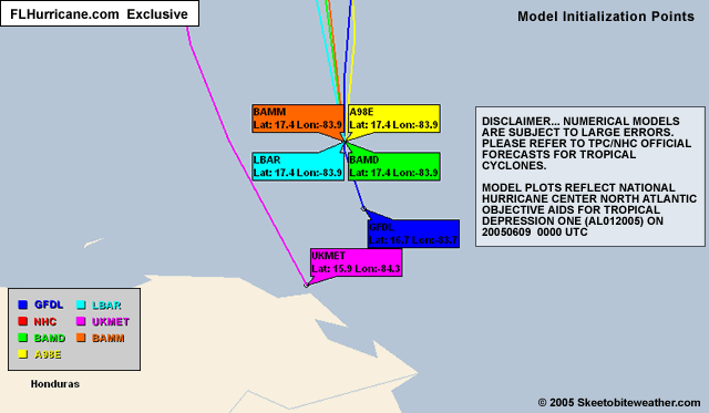
I looked at the UKMET model on the maps and it has this storm initialized too much to the west, in my humble opinion. I think until it gets into the GOM and starts moving, we're not really gonna know what the impacts will/won't be on the State of Florida.
I saw that 91L invest...was that the one you were referring to, HF?
Hmmm. It's only June 9th.
--------------------
You know you're a hurricane freak when you wake up in the morning and hit "REFRESH" on CFHC instead of the Snooze Button.
|
Terra
Storm Tracker
Reged:
Posts: 286
Loc: Kingwood, Texas
|
|
Quote:
but all her convection (at least as of now) will traverse the narrow part (remember how little affect that had on ), so i just want to see how she survives that trek...prolly little affect but for such a lopsided storm it may well play a role...
I'd have to agree with the latter comment more. With a weak storm, such as this, I can see even a small land interaction having an effect. wasn't phased, but this storm is nothing like .
--------------------
Terra Dassau Cahill
|
Droop31
Weather Watcher
Reged:
Posts: 32
Loc: Pensacola
|
|
Ivans eye remained largely over water while a portion of the eyewall clipped extreme western Cuba. I ust dont see alittle strip of land affecting an already unorganized TS. Also, the fact she's supposed to pick up speed I think Cuba will just be a minor bump in the road.
|
Colleen A.
Moderator
Reged:
Posts: 1432
Loc: Florida
|
|
StormHound - you got my curiousity up last night: am I really in the Cone of Death? How do they figure that?
Phil -- not being off-topic or flippant, just curious as to why I would be in the Cone of Death. 
--------------------
You know you're a hurricane freak when you wake up in the morning and hit "REFRESH" on CFHC instead of the Snooze Button.
|
Tazmanian93
Weather Master
Reged:
Posts: 495
Loc: Tampa
|
|
Colleen, thanks, that is a good one, let me know if you come across one that by city/county breaks it down even further to determine right on an area of landfall. Are Thing 1 and 2 watchers also  )) My son is in Dothan visiting Grammy for the summer, keeping my eyes unusually close for so early in the game. )) My son is in Dothan visiting Grammy for the summer, keeping my eyes unusually close for so early in the game.
--------------------
Don't knock the weather; nine-tenths of the people couldn't start a conversation if it didn't change once in a while.
Go Bucs!!!!!!!!!
****************
Ed
|
Colleen A.
Moderator
Reged:
Posts: 1432
Loc: Florida
|
|
I agree with you, Droop. I don't know that the actual "center" will go over the tip of Cuba...the convection might. However, even if it does, it's going over the narrowest and lowest part of the Island of Love and Humanity, so I really don't think it will tear it to pieces.
I do believe that this will be a major rain event for Florida. But I have a question: which scenario would be worse for Florida:
1. The center stays 200 miles off the coast of Florida, meaning we get all the effects of the eastern quadrant of the storm or
2. The center is closer to the coast (say, a brush with Ft. Myers) and the outer bands are mostly over the Atlantic Ocean.
Then again, there's
3. It stays closer to the coast, and as it pulls away, we get the rain bands.
I really don't see how Florida won't be affected by it one way or the other. You can already feel the tropical moisture in the air - it's heavier than usual.
Just some random thoughts flying through my head.
--------------------
You know you're a hurricane freak when you wake up in the morning and hit "REFRESH" on CFHC instead of the Snooze Button.
|
Colleen A.
Moderator
Reged:
Posts: 1432
Loc: Florida
|
|
I haven't found one that breaks it down that closely. I'd use 's maps for that. No, Thing 1 & Thing 2 do not "watch". I say "tropical storm" and they automatically head to the closet. I've been doing that since Christmas. 
--------------------
You know you're a hurricane freak when you wake up in the morning and hit "REFRESH" on CFHC instead of the Snooze Button.
|


 Threaded