HCW
Storm Tracker

Reged:
Posts: 287
Loc: Mobile,AL
|
|
NW movt at the 2am adv . This thing is going to hit us after all
--------------------
Over 4,000 members and now on a new server
http://www.hardcoreweather.com
|
Frank P
Veteran Storm Chaser
Reged:
Posts: 1299
|
|
Arlene has moved NW during the past 3 hours per the 1:00 am update
|
Storm Hunter
Veteran Storm Chaser

Reged:
Posts: 1370
Loc: Panama City Beach, Fl.
|
|
http://www.srh.noaa.gov/ridge/evx_long.html
turn on lat lon and loop image
--------------------
www.Stormhunter7.com ***see my flight into Hurricane Ike ***
Wx Data: KFLPANAM23 / CW8771
2012== 23/10/9/5 sys/strms/hurr/majh
|
Frank P
Veteran Storm Chaser
Reged:
Posts: 1299
|
|
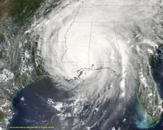
looking at that pix doesn't the center look a lot farther north than the 27.5N as given by the ?
|
mojorox
Weather Watcher

Reged:
Posts: 46
Loc: Orlando
|
|
I just have a bad feeling about New Orleans....
|
Frank P
Veteran Storm Chaser
Reged:
Posts: 1299
|
|
I just can's see it getting to the Big Easy but if it did that would make a lot of people look really really silly.... wonder if the warnings will shift left at 4:00 am... the NW motion was not projected by the at any time.... and it went more west than north in the past three hours... maybe it will revert to a more north than west in the next three
|
Storm Hunter
Veteran Storm Chaser

Reged:
Posts: 1370
Loc: Panama City Beach, Fl.
|
|
per elgin radar.......most cells in storm...some on the outerwall are around 25ft high....yet to find anything higher...also curious why there is no tornado watch yet for the panhandle....almost certain at 4adv there will be one....also winds have picked up just a little...rain is heavier to now...love the sound of the wind!!!!
--------------------
www.Stormhunter7.com ***see my flight into Hurricane Ike ***
Wx Data: KFLPANAM23 / CW8771
2012== 23/10/9/5 sys/strms/hurr/majh
|
hurricane34
Unregistered
|
|
This storm is sick...No convection and the convection it did have over its northeastern quad has faded. It is a bunch of Cirus or Stratus clouds. I say it is no more then 50 knots at most. Tropical storm Bill of 2003 looked a million times better.
In believe it or not the first recon found that it was cold core. I would not be at all suprized if this was subtropical. The name will be just like Grace...Both sorry examples of tropical cyclones.
|
danielw
Moderator

Reged:
Posts: 3525
Loc: Hattiesburg,MS (31.3N 89.3W)
|
|
Quote:
http://www.srh.noaa.gov/ridge/evx_long.html
turn on lat lon and loop image
Thanks, that's a really good tool.
I checked the reporting stations about an hour ago, from AQQ-Appalachicola to KBVE- Boothville, LA
Boothville was 1mb or so lower than any of the MS,AL,FL stations. With New Orlens right in a tight group with Destin and Pensacola.
In other words...she might drift toward the region of lowest surface pressure too!.
I 'll have to check SPC for the upper air pressures.
http://www.spc.noaa.gov/exper/mesoanalysis/s3/index2.html
Edited by danielw (Sat Jun 11 2005 06:32 AM)
|
Storm Hunter
Veteran Storm Chaser

Reged:
Posts: 1370
Loc: Panama City Beach, Fl.
|
|
well folks off to bed.....going to be a long morning...expect landfall after noon as a ts...60-70mph....her chances of cat 1 are fading
went surfing this evening not good, but better than nuthin 3-5ft...ne winds though....water was very warm...say around 80 or so.....for surfers check out reports for PCB at www.mrsurfs.com ....updated 3 times a day with pics
also when using the ridge web site be sure to hit refresh on your browser to keep up to date images.....
WMBB 13 is doing cuttins ever 30 mins and 7 is doing hourly
--------------------
www.Stormhunter7.com ***see my flight into Hurricane Ike ***
Wx Data: KFLPANAM23 / CW8771
2012== 23/10/9/5 sys/strms/hurr/majh
|
Rabbit
Weather Master

Reged:
Posts: 511
Loc: Central Florida
|
|
latest recon report has winds down to 55-60 mph and 993 mb pressure
|
Hurricane54
Unregistered
|
|
RIP you will be lucky to make landfall as a tropical storm at this rate.
|
berrywr
Weather Analyst

Reged:
Posts: 387
Loc: Opelika, AL
|
|
I posted earlier about a MCC moving due W. I think has finally gotten herself together and the little clear dot just to the east of the MCC appears to be what some might consider an "eye" or the latest in new centers. Last couple of frames on satellite show her consolidating around this fix and a general movement to the NW. I think will have to consider moving watches & warnings westward. I wish I had looked at this sooner, but if everybody looks at the 500mb UAA and the 11/06Z RUC, you'll note a COL to the storms NW and WNW. Why I didn't think of that earlier, I don't know. I am on record for a AL/FL landfall and I'm eating milkbone biscuits today! I think most of felt that what appeared to be a twice yesterday would be the main center; it is, but not at the surface. depicts this quite well in the mid levels. It wasn't until 90 minutes ago, I felt this way. But when that MCC fired up, time to rethink that NW movement depicted. I'd kill to have their satellite links!!!
--------------------
Sincerely,
Bill Berry
"Survived Trigonometry and Calculus I"
|
Rabbit
Weather Master

Reged:
Posts: 511
Loc: Central Florida
|
|
the convection, or whats left of it, has wrapped all the way around the west edge and the center has moved back underneath, so it is *POSSIBLE* that it could still strengthen a bit today
IR image
radar
there also still seems to be a well-defined center, and what may possibly be the beginnings of a northern eyewall trying to form
Edited by Rabbit (Sat Jun 11 2005 07:42 AM)
|
Hurricane Fredrick 1979
Weather Guru

Reged:
Posts: 116
Loc: Mobile,Alabama
|
|
Where did you get the recon info from?
|
danielw
Moderator

Reged:
Posts: 3525
Loc: Hattiesburg,MS (31.3N 89.3W)
|
|
NHC website...under Aircraft recon on the left side.
http://www.nhc.noaa.gov/reconlist.shtml
Latest report showing she is still Alive.
URNT11 KNHC 110757
97779 07204 70294 85019 15400 13065 14149 /2463
RMK AF305 0901A OB 06
29.4 85.0 location of report only!
154 dkm above surface (5051ft )
13065 wind 130deg SE at 65kts
1414 Temp 14C dew point 14C (relative humidity near 100%-rain)
The winds at 5051ft will reduce to a lower speed at the surface. /TPC has a formula for this, but I'm not sure what it is. I would think that 75% of the 65kts would be a safe reduction to the surface.
That would be around 49kts or 57 mph at the surface...this is My guess. You'll have to wait on to give a statement to get their actual surface wind speed.
Arlene is a strange storm and I'm not sure how they are able to keep up with her ramblings and vortices.
|
Hurricane Fredrick 1979
Weather Guru

Reged:
Posts: 116
Loc: Mobile,Alabama
|
|
Quote:
NHC website...under Aircraft recon on the left side.
http://www.nhc.noaa.gov/reconlist.shtml
Latest report showing she is still Alive.
URNT11 KNHC 110757
97779 07204 70294 85019 15400 13065 14149 /2463
RMK AF305 0901A OB 06
29.4 85.0 location of report only!
154 dkm above surface (5051ft )
13065 wind 130deg SE at 65kts
1414 Temp 14C dew point 14C (relative humidity near 100%-rain)
The winds at 5051ft will reduce to a lower speed at the surface. /TPC has a formula for this, but I'm not sure what it is. I would think that 75% of the 65kts would be a safe reduction to the surface.
That would be around 49kts or 57 mph at the surface...this is My guess. You'll have to wait on to give a statement to get their actual surface wind speed.
Arlene is a strange storm and I'm not sure how they are able to keep up with her ramblings and vortices.
Got that right. I'm doing good to keep up with just the path  But it did go down from 70mph to about 60 right? I look for it to regain strength if this did happen. The water temp there is about 85 deg. But it did go down from 70mph to about 60 right? I look for it to regain strength if this did happen. The water temp there is about 85 deg.
|
danielw
Moderator

Reged:
Posts: 3525
Loc: Hattiesburg,MS (31.3N 89.3W)
|
|
Recon reports aren't usually useful to upgrade or downgrade the storm. They are more of a position report for the aircraft and crew.
They normally fly a fixed pattern, and their reported winds will vary greatly. Even over 5 miles!
The new Advisory should be out soon and the will let everyone know what is doing. At least what they and the computers think she is doing.
I was looking at some of the High Density observations from NOAA earlier and the wind speeds would vary as much as 15 kts over 6 miles. Windspeed woud drop off a few kts and then a few more miles it would either increase about 15 kts or continue to drop.
If you do a search on Hurricane Research Division, they have some wonderful graphics from past Hurricanes. You can get an idea of what they are gathering as they fly. It will give you a different dimension to look at.
The upper structure of the storm in relation to, what you already know or see, the surface region of the storm.
|
danielw
Moderator

Reged:
Posts: 3525
Loc: Hattiesburg,MS (31.3N 89.3W)
|
|
Please use this link for the full 5 AM Advisory. Or you may scroll up on the left side of the page and use that link.
http://www.nhc.noaa.gov/text/refresh/MIATCPAT1+shtml/110836.shtml
|
James88
Weather Master

Reged:
Posts: 576
Loc: Gloucestershire, England, UK
|
|
Looks like there is now a convective burst going on rather close to the centre.
|


 Threaded


 But it did go down from 70mph to about 60 right? I look for it to regain strength if this did happen. The water temp there is about 85 deg.

