MikeC
Admin
Reged:
Posts: 4612
Loc: Orlando, FL
|
|
Thanks for HankFrank for the buzzphrase of the day "Forecasting Nightmare Deluxe", which describes exactly what's going on with Isidore. Especially on the intensity side.
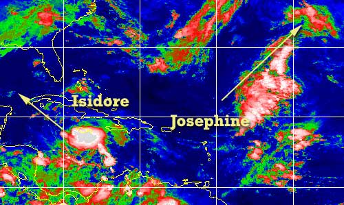
Josephine and Isidore have formed, Isidore in the Caribbean from tropical depression ten, and Josephine from tropical depression eleven in the middle of the Atlantic. Josephine will twirl red snappers, while the Isidore looks like it will be clipping the western tip of Cuba and entering into the gulf. (As of now anyway) . The big wildcard is intensity, and I fear that once (and if) Isidore starts to strengthen it will do so rapidly. Which, with current models, places it in the central Gulf, and anyones guess as to where it may wind up. This is the forecasting nightmare deluxe that we speak of.
Apologies once again as I have been away most of the week and the remainder of it. John has been writing the previous few updates and probably the next few. It will be the weekend before I'm back around.
Anyone in the gulf will want to watch Isidore. .
NRL Monterey Marine Meteorology Division Forecast Track of Active Systems (Good Forecast Track Graphic and Satellite Photos)
NASA GHCC Interactive Satellite images at:
North Atlantic Visible (Daytime Only), Infrared, Water Vapor
Some forecast models:
NGM, AVN, MRF, ETA ECMWF
DoD Weather Models (NOGAPS, AVN, MRF)
AVN, , , , , UKMET
Other commentary at Mike Anderson's East Coast Tropical Weather Center, Accuweather's Joe Bastardi, Hurricane City, Gary Gray's Millennium Weather, Barometer Bob's Hurricane Hollow, Snonut, Ed Dunham and Jason M in our Storm Forum Even more on the links page.
- [mike@flhurricane.com]
|
JustMe
Weather Guru

Reged:
Posts: 128
Loc: Orlando, Florida
|
|

Good Morning all
Here is Orlando.. I think the weathermen are holding off not commiting anything to anyone about everything. How can someone tell what to expect? Is there nothing that gives us the odds of what might be come Sunday or Monday re this storm? I have company coming and they sure don't want a hurricane. Thanks for any help.. I haven't had any replies yet when I have said something here. Would love some ideas of odds
--------------------
I have survived Betsy Miss, Camille Miss., Andrew Fl, Charley Fl, Frances FL, Jeanne FL,
|
Anonymousnickd
Unregistered
|
|
models,models,models??? can someone explain to me why the models are now more westward in nature. is it because of the slowing down by the storm? when he finally moves again will the models then shift right? i remember they did the same thing early on and then shifted right again. i also noticed that the still has the same 72 hour point as they did 12 hrs ago. can someone explain to me the impact of the troughs or lack of. thanks.
|
Anonymous
Unregistered
|
|
Here's a reply for ya. Sorry that you got lost in the shuffle. I think most everyone reads all the posts and probably is as confused as you with Isadore. All the bias in the models have shifted west. That's a BIG surprise for me as I expected the 2nd trof to ensure that Isadore would never be in the picture for any forecast in my area. But things change. Go read Bastardi today as he discusses the possibilities. He speculates that the first two trofs fail to pick up the storm. I figured that the 2nd one provided me shelter. Well chances are it's a 3rd trof - cross polar even brrrrrrrrr - that may end up doing the dirty work. Isidore relative to the 3rd trof next week will then make his decision.
nickd - I've noticed the same thing - left, right, left, right left. You'd think this system was under marching orders from a drill sargeant. Who knows? What we do know is there will likely be a Category 3 storm in the Gulf that could affect anyone from Mexico to Brownsville then from New Iberia to Key West. Rarely is speculation this wide with something this close in. Frankly, I still don't have a call but am hedging my only post on this storm to date from last night when I said LA was out of the woods. My 2002 target was Biloxi/Gulfport, so I guess that may be as good of a place as any 144 hours out.
Speaking of previous forecasts, yours truly, 'Weather Guru' ended up debunking Gary Gray's forecast pattern for the year, Dr. Bill Gray's numerical forecast for the year, and Joe Bastardi's landfall prediction from Appy to Buras for the year. Not bad for a blowhard amateur  . I'll be riding that proverbial train for the rest of the year. For all the b.s. calls we make, it's nice to be right once in a while and is worth a little extra horn tootin'! . I'll be riding that proverbial train for the rest of the year. For all the b.s. calls we make, it's nice to be right once in a while and is worth a little extra horn tootin'!
Steve
|
JustMe
Weather Guru
Reged:
Posts: 128
Loc: Orlando, Florida
|
|
thanks for taking the time to answer.
I appreciate it.. I am attempting to learn all of this info that you all hand out.
thanks again and will watch the weather watchers as they work their way through this one. Looks like it is going to be really interesting.
My newsman just said maybe Flroida again. So who knows..
(laughing out loud) Could be in for some really exciting times more so than Disney or Universal have to offer.
--------------------
I have survived Betsy Miss, Camille Miss., Andrew Fl, Charley Fl, Frances FL, Jeanne FL,
|
Anonymous
Unregistered
|
|
Agree Steve, I think the models will shift again, and I have friends who are leaving for Key west Friday night wanting to know what to do!! I just can't justify the west movement. Even with the , it has the storm moving WSW towards mexico with no strong ridge aloft or to the north. I guess it just has it riding the backside of the front west. I cannot agree with some that say Florida is out of the woods, which I read this morning. If anything, it's the logical place for this to go, since if it drifts toward the central GOM it will eventually get picked up by a trough, if not the 2nd the final cold front. But that's my opinion. In terms of real weather, Izzy is moving NW and this motion should continue. The last recon saw a slight shift to the north of NW albeit temporary. OK, bottom line, what do I tell those going to Key West?? Arrggh!! Cheers!! Steve H.
|
JustMe
Weather Guru
Reged:
Posts: 128
Loc: Orlando, Florida
|
|
Here in Orlando the weather forcaster Glen Richards says he feels that the strom will recurve back to Florida and we will be dealing with it this weekend
Anyone else feel this way ?
--------------------
I have survived Betsy Miss, Camille Miss., Andrew Fl, Charley Fl, Frances FL, Jeanne FL,
|
Mike
Weather Watcher
Reged:
Posts: 40
Loc: Port St. John, Fla
|
|
"Izzy" pressure is starting to drop. Down to 1004mb.
|
Anonymous
Unregistered
|
|
Though with a storm just a little west of there, they may well have some squally weather. I also doubt the storms turns into the peninsula - at least initially. As to the SW movement, HF posted on that last night. I think it's as likely as a LA-NW FL landfall down the line. What the trofs do (e.g. how far they dig et al) and what their effect is on the Gulf climate will have a huge say. Everything's gonna go back and forth unless the Canadian has been right all along in which case Izzy does hit FL this weekend. It appears to be the current odd model out (must have put on some weight or something ). For now, we've all got 5-7 days to watch this, fret, and probably come up with 300 posts between us.
Steve
|
Rasvar
Weather Master

Reged:
Posts: 571
Loc: Tallahassee, Fl
|
|
nickd: There was a little comment in the last discussion about the model shift. Some of it seems to be just becuase the models had more data to injest.
From the discussion:
LARGE-
SCALE MODELS...AIDED BY DATA FROM THE NOAA GULFSTREAM JET MISSION
LAST EVENING...INDICATE THAT THIS RIDGE SHOULD PERSIST THROUGH 72
HR EVEN THOUGH A DEEP-LAYER TROUGH SHOULD APPROACH THE WESTERN
GULF COAST BY 72 HR. THIS PATTERN SHOULD ALLOW ISIDORE TO MOVE
GENERALLY NORTHWESTWARD FOR 48-72 HR...AND THIS IS SUPPORTED BY
ALL TRACK GUIDANCE. THE OFFICIAL FORECAST IS SLIGHTLY TO THE LEFT
OF THE PREVIOUS PACKAGE...AND IS ALONG THE RIGHT SIDE OF THE
GUIDANCE ENVELOPE.
--------------------
Jim
|
Anonymousnickd
Unregistered
|
|
i may be off base here but isn't this the only west based model runs in the last 48 hrs...if not more. and remember the is to the right of the guidance package. they did this for a reason. they need to see some consistancy as well. any thoughts?
|
wxman007
Meteorologist
Reged:
Posts: 617
Loc: Tuscaloosa, AL
|
|
Notice how they ALL shifted west last night? The reason why is better data....the NOAA Gulfstream High Altitude research aircraft was sampling around the storm, and this data finally got put into the models
Not saying the more westerly tracks are right, but the model runs that incorporated that data last year were significantly more accurate.
Looking REALLY interesting...
--------------------
Jason Kelley
|
Anonymous
Unregistered
|
|
Here is the latest recon data Wind 57knots now.
000
URNT12 KNHC 181110
VORTEX DATA MESSAGE
A. 18/1110Z
B. 17 DEG 39 MIN N
78 DEG 30 MIN W
C. NA
D. 30 KT
E. 325 DEG 019 NM
F. 062 DEG 27 KT
G. 327 DEG 013 NM
H. EXTRAP 1004 MB
I. 22 C/ 427 M
J. 24 C/ 413 M
K. 24 C/ NA
L. NA
M. NA
N. 1345/1
O. 0.2/3 NM
P. AF985 0710A CYCLONE OB 18
MAX FL WIND 57 KT N QUAD 0940Z. SLP EXTRAP FROM 1500FT.
|
Anonymousnickd
Unregistered
|
|
thank you mr kelly. whats your thoughts on izzy?
|
Richie at work
Unregistered
|
|
The models have gone right, left, right, left, but overall the track really HASN'T changed very much. It still leans toward the tip of Cuba. The thing that has really changed is the slower movement of the storm. This could be the bigger factor, because it may let the storm intensify more. Storms in this location really don't curve back towards Florida until about a month from now. Also, the bigger the storm the straighter the line, usually. Follow the track of Camille, this may be the type of track we will see.
|
Anonymous
Unregistered
|
|
6z puts it in just east of N. Orleans at 108 knots. BTW Just ME didn't Glen Richards say recurve back to Florida Last Night...or was it this morning?? Cheers!! Steve H.
|
Bruce
Weather Guru
Reged:
Posts: 139
Loc: Palm Bay, Florida
|
|
Does anyone have the URL to the Havana radar link?
|
Anonymous
Unregistered
|
|
nhc model shifts back some to the right. it will slow just on west tip of cuba, trof will push back to fla. as high backs to east.
|
Anonymous
Unregistered
|
|
where did you get this info?
|
Anonymous
Unregistered
|
|
on , 72 hour swath of movement moved some to the right. ridge over fla. will stay there maybe to saturday , then front comes into western gulf, as high weakens over fla.
|


 Threaded


