Hurricane Drew
Registered User
Reged:
Posts: 4
|
|
Quite an impressive buzz-saw hurricane. Hopefully it weakens considerablly over Cuba. Looks more like a NNW track to me, but could just be slight jogs over land.
|
WeatherNLU
Meteorologist

Reged:
Posts: 212
Loc: New Orleans, LA
|
|
Correct, and am I glad to see that!!! I hadn't noticed, but that's a good sign for us here. Now no models have New Orleans taking the eastern side of the storm. We can breathe a little easier.
--------------------
I survived Hurricane Katrina, but nothing I owned did!
|
ShanaTX
Storm Tracker
Reged:
Posts: 226
Loc: Texas
|
|
From http://news.yahoo.com/news?tmpl=story&u=/ap/20050708/ap_on_re_us/hurricane_dennis_us_7
Quote:
An estimated 40,000 residents and tourists were ordered out of the beachside town of Gulf Shores, Ala., on Friday, and evacuation was also requested in a flood-prone parish south of New Orleans that is home to 458,000. Mississippi officials planned an announcement later in the day.
Inland-bound traffic along the coast was already growing heavy, and hotels were filling more than 150 miles to the north.
"All day long all of our phones have been ringing. The only thing we can tell people is that we are sold out," said Lasonya Lewis, a desk clerk at a Courtyard by Marriott in Montgomery, Ala.
In Florida, some gas stations had run out of fuel Friday, and cars lined up at those that still had supplies. State officials said fuel supplies and distribution were normal, and dry pumps would be restocked by Saturday.
'shana
|
Rick on boat in Mobile
Weather Drama Guru

Reged:
Posts: 161
|
|
which made somewhat change it's heading....
land could somewhat change the path...enough to throw the models and everyone into a slight "correction"
it will be interesting to see what path over Cuba takes....
gusts at 184 over cuba.....around 10:00....can you imagine hunkering down in that?.......
|
Lysis
User

Reged:
Posts: 451
Loc: Hong Kong
|
|
Could you imagine hunkering down in that?
... Unfortunately, yes. 
--------------------
cheers
|
Katie
Weather Guru

Reged:
Posts: 167
Loc: Winter Haven, FL
|
|
Liz - I heard he was approximately 300 miles across....I could be wrong seeing as how, I heard that on Fox News...
|
tornado00
Weather Hobbyist
Reged:
Posts: 85
Loc: Maitland, Florida, USA
|
|
At that speed, there would be nothing to hunker down in.
--------------------
Derek Sutherland
|
Ed in Va
Weather Master
Reged:
Posts: 489
Loc:
|
|
So how about a pool on when the eye gets back over water...I'll go with 11:30.
--------------------
Survived Carol and Edna '54 in Maine. Guess this kind of dates me!
|
Hurricane Drew
Registered User
Reged:
Posts: 4
|
|
Yes, that would be pretty scary. Had our share of Charlie, Francis, & Jeanne last year, all going through out County in Florida (Highlands). No gusts of 180, that is for sure though...
|
poetdi
Verified CFHC User

Reged:
Posts: 14
Loc: Maitland, FL
|
|
Hi all - first post for this season - feeling deeply for those in Cuba and all those in ' path.
This link describes Delta's policy on rescheduling airline tickets - thought you might find it interesting given the number of folks posting about whether they should change their travel plans or not. Probably most/all airlines have a similar policy of suspending change penalties due to this storm - a good thing.
http://www.delta.com/travel/before/travel_updates_flight_info/dennis_070605/index.jsp
Diane 
|
Rick on boat in Mobile
Weather Drama Guru
Reged:
Posts: 161
|
|
cat 1---hohum
cat 2---shoot
cat 3---ouch
cat 4--outta here
cat 5--nutting left
and for
cat damn...
|
Hurricane Drew
Registered User
Reged:
Posts: 4
|
|
Sad but true!
|
Lysis
User
Reged:
Posts: 451
Loc: Hong Kong
|
|
made landfall here at that exact same intensity (145 mph, 941 mb).
If you are curious... this is comparable to what Cubans near Cienfuegosa are going through right now:
http://www.extremestorms.com/Charlie%20Core-%20Punta%20Gorda.wmv
--------------------
cheers
|
Jeffmidtown
Weather Guru

Reged:
Posts: 132
Loc: Atlanta, Ga
|
|
Does anyone have the web address for the Florida DOT that has the traffic count rates going in and out of Florida?
--------------------
You know it's a bad day.....when you wake up and see Jim Cantore and Geraldo Rivera broadcasting from your backyard....literally!
|
MissBecky
Weather Guru

Reged:
Posts: 112
Loc: Ft. Myers, FL
|
|
It just started *pouring* here. Very breezy, too.
|
Jenny
Verified CFHC User
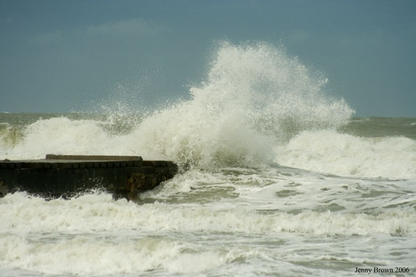
Reged:
Posts: 16
Loc: Bradenton, Florida
|
|
http://www3.dot.state.fl.us/trafficinformation/
--------------------
Jenny
www.bbdigitalphoto.com
|
tornado00
Weather Hobbyist
Reged:
Posts: 85
Loc: Maitland, Florida, USA
|
|
Poetdi, what part of Maitland do you live in? We're probably right under each others noses. 
--------------------
Derek Sutherland
|
Liz
Weather Watcher

Reged:
Posts: 31
Loc: Daytona Beach, Florida
|
|
Unbelievable !!!!! 
I can't begin to imagine what 184 mph will do.
Liz
|
Lysis
User
Reged:
Posts: 451
Loc: Hong Kong
|
|
Yes, everyone is south Florida take a look at the high cirrus clouds overhead, and the increasingly overcast sky. Southern Florida is already being affected by tropical moisture part of 's circulation. The most amazing thing is track something across thousands of miles, and then see part if it at home… so check it out, and stay aware of what is happening around you and how it plays out in the big scheme of things (I suppose some of us will see more than we would like).
--------------------
cheers
|
Katie
Weather Guru
Reged:
Posts: 167
Loc: Winter Haven, FL
|
|
Miss Becky - we just got our second span of rains this afternoon. It came down like cats and dogs and then just as quick as it started - it stopped. And now it is clear again. Pretty breezy too.
|


 Threaded


