pcola
Storm Tracker

Reged:
Posts: 344
Loc: pensacola/gulf breeze
|
|
I saw that on the radar Scott...probably a west wobble....still very close to forecast
--------------------
Erin 95 , Opal 95, Ivan 04, Dennis 05, and that's enough!!!!
|
Rick on boat in Mobile
Weather Drama Guru

Reged:
Posts: 161
|
|
everything realistically still up in the air....isn't it....note this partial post from Accuweather...
There continues to be different ideas on the exact track. The interaction with the higher terrain of Cuba could alter the hurricane's structure and cause it to react differently to the steering currents. The upper-level high pressure ridge has weakened over Florida and the eastern Gulf while a strong upper-level disturbance is now diving into eastern Texas. This will help to maintain a weakness in the upper-level wind flow over the central Gulf and will turn northward ahead of this weakness. If the Atlantic high pressure ridge fails to build farther west could track close to the west coast of Florida. If the upper-level high pressure ridge builds stronger to the west, then will be diverted more toward Louisiana. As far as intensity changes, is a Category 4 and should lose at least some strength over Cuba today and tonight. Once the storm moves back over the southeast Gulf it should regain some strength. It has been pointed out by various sources that the depth of very warm water is less over the eastern Gulf of Mexico and this might prevent from strengthening. However, this is all speculation.
|
Margie
Senior Storm Chaser

Reged:
Posts: 1191
Loc: Twin Cities
|
|
Looks like you are right it was skirting the coast, however some of the eye wall was over land. Now the lastest sat looks like the eye is just to the west of Cienfuegos and on land.
--------------------
Katrina's Surge: http://www.wunderground.com/hurricane/Katrinas_surge_contents.asp
|
rmbjoe1954
Weather Master

Reged:
Posts: 427
Loc: Port Saint Lucie, Florida, USA
|
|
Dennis is generally going the way predicted it would- west Fl will get soaked and windy (up to TS strength) with the threat of tornadoes and flooding; but the panhandle will be under the gun- obviously, it is too early to say where.
--------------------
________2023 Forecast: 20/10/5________
There is little chance that meteorologists can solve the mysteries of weather until they gain an understanding of the mutual attraction of rain and weekends. ~Arnot Sheppard
|
tpratch
Moderator

Reged:
Posts: 339
Loc: Maryland
|
|
Quote:
If you go back to my earlier thread,you will see I said eastern or central Cuba.And it is NOT western Cuba is it?
Sorry I missed your reply earlier.
I believe this shows that it is projected to wrap up the crossing in what is undeniably western cuba. (images from the latest visible and infrared loop with the track coming from actual and forecast points).
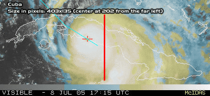
Sorry that it's quick and dirty but back to my question - how does a crossing of Western Cuba support a South Florida hit?
I just want to understand where you're coming from.
|
Lysis
User

Reged:
Posts: 451
Loc: Hong Kong
|
|
Right now I still think that he will come off east of Havana... a little east of the forcast.
--------------------
cheers
|
Jamiewx
Storm Tracker

Reged:
Posts: 371
Loc: Orlando, Florida
|
|
This closer image from RAMSDIS is probably better than the floater.
Tropical RAMSDIS
Edit: Link is fixed
Edited by Jamiewx (Fri Jul 08 2005 06:16 PM)
|
WeatherNLU
Meteorologist

Reged:
Posts: 212
Loc: New Orleans, LA
|
|
Quote:
WeatherNLU: I think that what a lot of people are seeing on the WV loops that are causing them to think that this will go more NW/NNW is the fact that the short wave troughs are digging much deeper into the GOM and you CAN see an erosion of the high pressure system just east of Daytona. Clark has talked about this happening, Ed has talked about this happening and so has JK. This was a possibility all along. I'm not saying it's going to happen, but it's not something we can't totally discount. It was also addressed in the 11AM discussion and some of the models are picking up on this.
I just must be blind. I certainly do not see the high eroding at all, at the worst it's holding it's own.
--------------------
I survived Hurricane Katrina, but nothing I owned did!
|
nccathy
Registered User
Reged:
Posts: 8
|
|
the link doesn't work
|
Baudelaire
Registered User
Reged:
Posts: 8
|
|
Wow I feel bad for those people getting beaten with that near category 5 eyewall right now.
|
StormDrain
Registered User
Reged:
Posts: 2
Loc: Pinellas County FL
|
|
Everyone I've talked to is having issues with the sats loading. It takes a long time, but once you have it up leave it up and hit refresh for newer images. It took 15 minutes for mine to load, but it did come up. Maybe they are experiencing heavy traffic and it's effecting the site
|
jr928
Weather Guru
Reged:
Posts: 101
|
|
Which models predicted and best?
|
VandyBrad
Weather Hobbyist

Reged:
Posts: 80
Loc: Bryan, TX
|
|
Wow, the last images on the sats totally loose the eye. It's almost like the eye got obliterated when it hit Cuba.
--------------------
Brad Shumbera
|
thomas alascio
Registered User

Reged:
Posts: 2
|
|
what is th eadress fro the 6 diff models you can run , Etc.. It allows you to run 24,48, 54 hours ahead of time. Anyone know where that is????? 
|
Liz
Weather Watcher

Reged:
Posts: 31
Loc: Daytona Beach, Florida
|
|
Link is working for me. He is HUGE  Does anyone know how large he is....how many miles across he is? Does anyone know how large he is....how many miles across he is?
Liz
PS....quess I was off about my prediction of the 1st named Hurricane 
|
Storm Hunter
Veteran Storm Chaser

Reged:
Posts: 1370
Loc: Panama City Beach, Fl.
|
|
i have the floater up all morning and saw what i think were two small vortices inside the eye just before landfall....pretty kewl!
right now appears thw whole eye has made landfall
lastest rapid scan vis
http://hadar.cira.colostate.edu/ramsdis/online/data/rmtcrso/131.jpg
--------------------
www.Stormhunter7.com ***see my flight into Hurricane Ike ***
Wx Data: KFLPANAM23 / CW8771
2012== 23/10/9/5 sys/strms/hurr/majh
Edited by Storm Hunter (Fri Jul 08 2005 06:42 PM)
|
doug
Weather Analyst
Reged:
Posts: 1006
Loc: parrish,fl
|
|
the high has become eliptical and is eroding to the east, kind of like a flat tire. use the RAMSDIS 14 k WV loop ...link is on the main page.
--------------------
doug
|
spencercape
Verified CFHC User

Reged:
Posts: 15
Loc: Cape Coral/Matlacha Pass, FL
|
|
http://moe.met.fsu.edu/tcgengifs/
---------
SpencerCape
www.techvr.com/weather.htm
--------------------
---------------------------------------------------
At least the weather here is nice January, February, March and some of April!
|
TDW
Weather Watcher
Reged:
Posts: 37
Loc: Mobile, AL
|
|
I notice the latest UKMET model now has shifted to landfall along the central Mississippi coast. Hadn't it been an outlier, with landfall in LA?
--------------------
"It's time to see the world
It's time to kiss a girl
It's time to cross the wild meridian"
|
Clark
Meteorologist
Reged:
Posts: 1710
Loc:
|
|
New blog posted answering some of the comments about the ridging, its evolution, and the related impacts on the track of ...plus guidance on the model guidance. Hope this helps to clarify any thinking and analysis with regards to the storm at this time.
--------------------
Current Tropical Model Output Plots
(or view them on the main page for any active Atlantic storms!)
|


 Threaded


