MikeC
Admin
Reged:
Posts: 4620
Loc: Orlando, FL
|
|
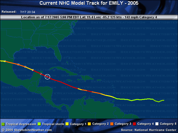
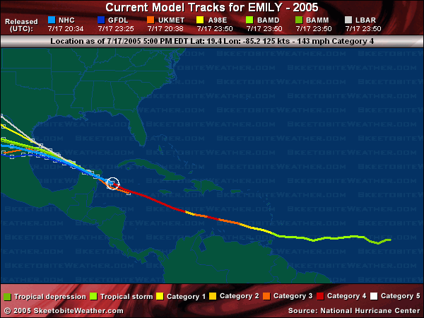
6PM 17.July Update
Emily is nearing the Yucatan this evening, and the eye is viewable on the Cancun radar. The eye was looking ragged earlier, but it looks like its reforming now.
Future track for a second landfall is still into Mexico, with southern Texas still inside the cone.
 
11AM 17.July Update
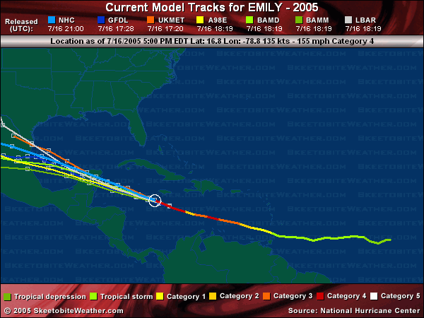
Emily is holding as a strong Category 4 storm, with a relatively small eye. Warnings are up for the Yucatan, and landfall will likely be overnight.
Since it is small it is likely to be weakened considerably by the yucatan so when it re-emerges in the Gulf it will still be a hurricane, but a much weaker one. And depending on how much the storm degrades, it may have a chance to become a major again for a second landfall most likely in Mexico near Tampico.

6PM Update
Hurricane Emily is now a high end Category 4 storm, 1 MPH shy away from Category 5 status. It is possible for it to become a Category 5 briefly still. It is still moving toward the Yucatan, and will likely be category 3 or 4 when it makes landfall along the eastern coast.

It will weaken some over land, and then emerge into the Bay of Camphece. A second landfall is Mexico beyond that is the most likely scenario. Folks up into southern texas will want to watch it as well.
99L is turning out to sea, leaving not much else currently in the tropics after Emily, which will be a welcome break.
Original Update
Hurricane Emily continues to Deepen in the Caribbean, now a category 4 storm, and has a chance at category 5, although if it does I doubt it will hold that extreme very long.
 
Emily is passing south of Jamaica, and the Caymans, but close enough that the Caymans will see strong winds, maybe as high as category 1 strength. Before it has moved on The Yucatan will have to deal with this directly later, and Hurricane watches will likely be up for parts of it later today.
Beyond that, and after it crosses the Yucatan. (Which should knock a lot of the intensity out of ti) it still looks like a Mexico hit or possibly Texas. The more likely of the two is into Mexico..
Event Related Links
StormCarib hurricane reports from observers in the Islands
Caribbean Island Weather Reports
Color Sat of Gulf (Animated)
RAMSDIS high speed visible Floater of Storms
Emily
Flhurricane mirror of cancun radar - Cancun Radar Loop Cancun, MX radar (Overloaded please use mirrors)
Tampico, MX radar
Visible/IR Floater of Emily with storm track Overlays
Animated Model Plot of Emily
Model Plot Graphic from the South Florida Water Management District of Emily
Emily Spaghetti Model from boatus
Weather Underground Model Plots for Emily
QuikScat Image of Emily
Dennis and emily plotted on a google map
Webcams, Video, Audio
Jim Edds/weathervine chasing hurricane Emily in Cancun
Cancun Webcams
Cozumel Webcams
Hurricane City's audio feed, show starts at 11PM EDT
Radio WX
Area east of Emily (99L)
Animated Model Plot of Area East of Emily 99L
Model Plot of Area East of Emily 99L (Graphic from the South Florida Water Management District)
|
SeeSaw03
Unregistered
|
|
Had a question for Clark but it got caught in the last thread. My computer doesnt seem to want to copy and pase this morning, so I'm hoping Clark takes a look at it over there.
Thanks.
|
Margie
Senior Storm Chaser

Reged:
Posts: 1191
Loc: Twin Cities
|
|
OK, visited the new Forecast Lounge forum, ready to make a forecasting fool out of myself! All as a way to provide a learning experience. Not anything happening over there yet so I hope you'll keep advertising the new forums.
Well I think this is the best of everything today - the opportunity to watch a strong storm develop, with no immediate landfall to put many folks in harm's way. Yesterday Emily had it out with that upper level TROF: she strapped on the pistols and announced, "Turn over the warm water, and no one gets hurt!"
--------------------
Katrina's Surge: http://www.wunderground.com/hurricane/Katrinas_surge_contents.asp
Edited by Margie (Sat Jul 16 2005 10:13 AM)
|
CDMOrlando
Weather Hobbyist

Reged:
Posts: 57
Loc: seminole cnty florida
|
|
Quote:
Had a question for Clark but it got caught in the last thread. My computer doesnt seem to want to copy and pase this morning, so I'm hoping Clark takes a look at it over there.
Thanks.
I copy your questions to the new thread.....
Hey Clark--
Given that Emily has ramped up considerably and may intensify a bit more, is there any way that she might steer on a slightly more northerly heading. Nothing significant, just perhaps a subtle change from ~285 to perhaps, say, ~290 or 295. Isn't it possible for very strong storms to eat into ridges a bit? Just was thinking perhaps she might miss the Yucatan that way, and perhaps spin down a bit in the Gulf of Mexico. As it looks now, the Yucatan Peninsula is going to take some serious heat from this thing.
Thanks. Appreciative of your insight, as always.
|
HCW
Storm Tracker

Reged:
Posts: 287
Loc: Mobile,AL
|
|
winds 145 gust 185 943 mb at the 11am adv
--------------------
Over 4,000 members and now on a new server
http://www.hardcoreweather.com
Edited by HCW (Sat Jul 16 2005 10:39 AM)
|
CaneTrackerInSoFl
Storm Tracker

Reged:
Posts: 395
Loc: Israel
|
|
If the storm does get to Texas coast area, there is 90 degree temperature water awaiting her. That could provide the energy for a last hurrah in strengthening if she weakens over a first landfall in the Yucatan.
--------------------
Andrew 1992, Irene 1999, Katrina 2005, Wilma 2005
|
ftlaudbob
Storm Chaser

Reged:
Posts: 829
Loc: Valladolid,Mx
|
|
What is going on with the threads?I am lost. 
--------------------
Survived: 10 hurricanes in Rhode Island,Florida and the Yucatan of Mexico .
|
ftlaudbob
Storm Chaser
Reged:
Posts: 829
Loc: Valladolid,Mx
|
|
Having lived in Playa Del Camen on the Yucatan for 3 years,I have this morning offerd my friends that are there a place to stay here with me.Also I am working with them for flight arrangments to get then out of there.Anyone who has been there knows,there is no place there that is safe,and I mean no where.Many times I used to sit on the beach there and say to myself Ïf a major hurricane ever hit here it would wipe this town out".Well it looks like that is what will happen.For those that have never been there,it is one of the coolest places on this earth.Please pray for all those who can not get out in time.
--------------------
Survived: 10 hurricanes in Rhode Island,Florida and the Yucatan of Mexico .
|
Clark
Meteorologist
Reged:
Posts: 1710
Loc:
|
|
Stronger storms do have a tendency to move a bit further north -- with the upper level flow -- than do weaker storms, but given the current flow pattern, there isn't a lot other than wobbling and the effects of Coriolis to help to move it off towards the north. It might move a little bit more WNW as it nears the Yucutan, but unless the western extent of the subtropical ridge erodes to some degree, it may well turn back moreso towards the west.
--------------------
Current Tropical Model Output Plots
(or view them on the main page for any active Atlantic storms!)
|
SeeSaw03
Unregistered
|
|
Thanks, Clark. I have just one more question. The five-day track takes this thing well into central Mexcico, still as a tropical storm. Any chance any of that rain will reach extreme southern New Mexico/Arizona, or will the storm most likely track over Mexico south of the U.S. (including the Southwest)?
|
Margie
Senior Storm Chaser
Reged:
Posts: 1191
Loc: Twin Cities
|
|
Quote:
What is going on with the threads?I am lost.
Unfortunately, no.
--------------------
Katrina's Surge: http://www.wunderground.com/hurricane/Katrinas_surge_contents.asp
|
recmod
Weather Guru

Reged:
Posts: 188
Loc: Orlando, FL
|
|
Quote:
If Emily reaches Cat 5 intensity, would that make her the earliest Cat 5 storm in history? (have there been others in July?)
The earliest Cat 5 recorded was 1980's Hurricane Allen, which reached Cat 5 intensity on 00Z August 5. At this point ,the storm had winds of 160mph with a central pressure of 911mb.
--Lou
|
Margie
Senior Storm Chaser
Reged:
Posts: 1191
Loc: Twin Cities
|
|
Looks to me like Emily's strengthening is done for now, and she maybe even weaken a little until later this aft/early evng, and then start to strengthen again. However the surface winds could still catch up before this happens, initially to go to 150-155 briefly, but then I am thinking they would fall back down to 145, 140, over the next three hours, then strengthening again.
Eye is very impressive. It has grown quite a bit - what are the implications of this, if any?
--------------------
Katrina's Surge: http://www.wunderground.com/hurricane/Katrinas_surge_contents.asp
|
HanKFranK
User

Reged:
Posts: 1841
Loc: Graniteville, SC
|
|
latest recon fix has the min pressure at 940mb and winds at 150mph.
HF 1655z16july
|
Margie
Senior Storm Chaser
Reged:
Posts: 1191
Loc: Twin Cities
|
|
Quote:
latest recon fix has the min pressure at 940mb and winds at 150mph.
HF 1655z16july
Not surprising considering Discussion 23 "...with 700 mb flight-level
winds as high as 148 kt. This would normally support surface winds
of 130-135 kt."
But look at the cloud tops on the west side the last couple sat photos - not as cold now. Although to Emily's credit she is staying compact.
--------------------
Katrina's Surge: http://www.wunderground.com/hurricane/Katrinas_surge_contents.asp
|
nl
Storm Tracker

Reged:
Posts: 207
Loc: nsb,fl
|
|
there is alot of waves out there which one is gonna be named first? 
|
Rick on boat in Mobile
Weather Drama Guru

Reged:
Posts: 161
|
|
has gotten larger, and is perfect now. I suspect Emily will be a cat 5 storm. Is there any chance that she could begin a more northward turn?....if this storm slips through the Yucatan, and hits NO...it'll be a disaster of monumental proportions.
Anyone on the Yucatan in anything less than a conrete block building....will be in serious danger of losing their lives....when they get to 150+...we all know it's now a question of survival.
HankFrank...watchya think?......could the ridge weaken?...could Emily head more north...?....I wonder....because she "appears" to edging ever so more north than west through the hours....
not wishcasting....I live on a boat, ya know...
no. maybe texas. more likely mexico all the way. -HF
Edited by HanKFranK (Sat Jul 16 2005 01:41 PM)
|
rdcrds
Unregistered
|
|
It is pretty much a given that this storm is headed for Mexico maybe lower teas but Mexico looks like its ending point.
Can you not tell by the lack of posts? since no big doom and gloom for the US its a non event to some.
Anyway as of this ADV little or no chance for NO.
|
52255225
Weather Guru

Reged:
Posts: 166
Loc: Parrish Fl
|
|
looking at the sat imagery if she stays on that northerly track it looks like the keys will get brushed by her.
|
Margie
Senior Storm Chaser
Reged:
Posts: 1191
Loc: Twin Cities
|
|
Don't know if you are reading your PMs...here is a website that shows websites to all the US Embassies and Consulates in Mexico:
http://usembassy.state.gov/
And here is the website for the Mexican ones in the US (note there is one in Boston):
http://www.mexonline.com/consulate.htm
--------------------
Katrina's Surge: http://www.wunderground.com/hurricane/Katrinas_surge_contents.asp
|


 Threaded