ShawnS
Storm Tracker
Reged:
Posts: 226
Loc: Pearland,Tx
|
|
If all this pans out then what kind of effects could I feel here in Pearland, which is only about 20 to 25 miles away from the coast, if that?
|
Steve
Senior Storm Chaser

Reged:
Posts: 1063
Loc: Metairie, LA
|
|
CHECK THIS OUT! We're under a feeder band right now. Look at the Goes 8 IR, and you'll see a little band up here connecting to the west side of the system. Blew my mind when I saw it on IR. Anyway, that makes either 4 or 5 storms that have rained on my house this year - 4 or 5 due to some confusion between what was Eduoard remains and what was Fay. Again, last time this has happened was 4 times precip from storms in 1985 - a bigtime analog year per some forecasters.
BTW, WHO DAT SAY DEY GONNA BEAT DEM SAINTS? 3-0 BABY!
Steve
--------------------
MF'n Super Bowl Champions
|
joepub1
Storm Tracker
Reged:
Posts: 240
Loc: Jacksonville,Fla
|
|
Shawn, your just south of Houston, right. Let me do a little calc real quick and we'll see.
|
Ed Dunham
Former Meteorologist & CFHC Forum Moderator (Ed Passed Away on May 14, 2017)
Reged:
Posts: 2565
Loc: Melbourne, FL
|
|
Thanks! I guess that one of these days I should really look over a little more of the 'stuff' on the site 
ED
|
MikeC
Admin
Reged:
Posts: 4624
Loc: Orlando, FL
|
|
Here's a photo I just want to keep for later...
|
Frank P
Veteran Storm Chaser
Reged:
Posts: 1299
|
|
Steve, Saints are 3-0... no way the hurricane is not going to miss the crescent city, and it's snowing in Hell to right now too I might add.
Funny thing.. Son's ballgame in W. Alabama rained out... so I get to watch the Saints... they get down 20-0... SOS... I think ... so I take my wife to the movie, heck with the game... find out later they win... geesh.... thank goodness for ESPN prime time highlights...
Hard to believe I'll be rooting for the Rams to win... hehe
well I'm ready for whatever comes... there is a lot of hype about the big turn to the NW and N... I'll believe it when I see it.... Not all convinced it will come out of the BOC... but smarter people than me are arguing otherwise... Joe B's assessment very interesting... I am going to ride out the storm regardless of strength on the Beach in Biloxi......... wife and two bassets will evacuate... kids in college... house survived Camille, and I've recently reinforced the entire structure with additional hurricane straps and ties... code requires at least one, I have three on everything.... could be an interesting week to come... most models still take the system quite west, except the ... which has hit every city that borders the GOM... Joe said it quite well earlier... the , along with all the other models are on the Axis of Evil list... I agree...
|
mbfly
Weather Guru

Reged:
Posts: 119
Loc: Mobile, Alabama
|
|
Hey Steve... are you sure that's not just part of the front coming down ? We just got pounded here in Mobile ! Still are as a matter of fact. It looks to me that on http://www.ssd.noaa.gov/PS/TROP/DATA/RT/gmex-ir4-loop.html that it's part of the "stuff" coming down from the north. It also looks to me that Izzy's eye is more on land now than in the water--maybe he's commiting suicide ? I took a 24 hour break from all this madness here this weekend and spent the day listing things to sell on e-bay (user name mbfly in case anyone is interested in old bottle labels ! ) All of this "here it comes" and "there it goes" is making me a nervous wreck. I have the basic hurricane prep box always packed.... batteries, 10yr old spam, water etc....but have done little more. This latest forecast is more than a little concerning. I STILL think there is no way Mobile is going to get 2 in a row ! My DH (Dear Hubby or Dumb Hubby; just depends) insists that he's not gonna board up unless he hears that Jason Kelly says so. Jason ???
|
cappycat
Verified CFHC User
Reged:
Posts: 16
Loc: Raceland, LA
|
|
I have been lurking over the last few days and have enjoyed the discussion and learned a great deal.
We are planning to evacuate if this monster heads towards New Orleans, though we have always stayed before. I am pregnant and concerned about the barometric pressure and pre-term labor. With the pressure being so low at the center of this thing, I figure the best course of action is load up me, the kids and the cats (hubby will join us later) and head north. But, I am curious. How dramatic is the difference in barometric pressure from the eyewall to the outer areas of the storm? I guess I am thinking of the difference of a direct hit vs. a glancing blow by the outer edges of the storm.
Thanks,
monique
|
Marcie
Unregistered
|
|
Hi All! I have been reading the posts here today trying to educate myself quickly. This is the first storm I have followed. My situation is this..I live in Atlanta but have a brand new beach home on Cape San Blas, Fl (25 miles west of Applachicola) We are scheduled to go down Thursday to meet the furniture delivery trucks. Don't really know what to expect or do at this point. The Cape is a little unusual in its shape. It sticks out like a finger and runs north to south. Our home is on the south end facing south. We have the ocean on one side and the bay on the other. Here is a link to an aerial of the Cape. www.c21gcr.com Could a cat 3 or 4 flood the Cape? I would appreciate any and all insight/advice.
Thanks,
Marcie
theparkers@bellsouth.net
|
joepub1
Storm Tracker
Reged:
Posts: 240
Loc: Jacksonville,Fla
|
|
Hey Shawn, it's gonna depend on if their is any NE movement after 72hrs, the didn't go beyond 25N 93W, and didn't say, unless I missed it, anything except that was a little to the east(In their opinion). If he rides 93W straight up he'll be less then 150 miles from you. Anything to the west and you'll tell us all about it from a personal point of view. It looks like Cat1 winds up to 100 miles from the center, TS winds up to 200. Water will be real rough(I had Floyd pass about 100 miles from here, he stirred it up pretty good), I don't think rain will be a huge deal unless he's on you. Keep track as gives more clues about where he's going, don't pay the models too much attention. Hope that helps, and best of luck.
Joe in JAX
|
troy2
Storm Tracker
Reged:
Posts: 227
Loc: cocoa beach
|
|
Marci
I am not sure. But the next storm that kinda sits down there like Izzy; I am heading up to your house to surf!
How close to that point are you??
troy
Edited by troy2 (Sun Sep 22 2002 06:08 PM)
|
Anonymous
Unregistered
|
|
KISS IT GOODBYE !!!! ....There wont be a cape left there.
|
Anonymous
Unregistered
|
|
I TOLD EVERONE THIS MORING SOMETHING WAS COMING THREW TEXAS THAT WOULD CHANGE EVERYTHING HERE IT IS GAME STARS NOW
|
Anonymous
Unregistered
|
|
Troy, we are about a half a mile from that point. Great shelling spot!
Still worried about the Panhandle. Would love some links to look at as I educate myself.
Marcie
|
Steve
Senior Storm Chaser
Reged:
Posts: 1063
Loc: Metairie, LA
|
|
It's both. It's part of the troffiness of the front, but look how it connects to the western side of Isidore. Kinda trippy.
Steve
--------------------
MF'n Super Bowl Champions
|
ShawnS
Storm Tracker
Reged:
Posts: 226
Loc: Pearland,Tx
|
|
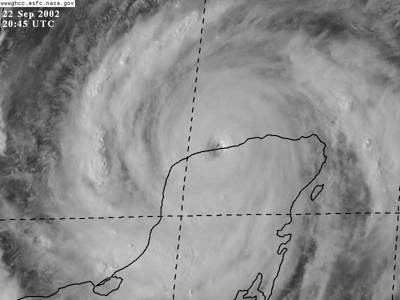
I tell you what, for something that was suppose to pretty much stay offshore, Izzy seems to be plowing inland pretty good. If this trend continues than all bets are off. I was thinking that maybe it was just a wobble but it just keeps going further inland. What do ya'll think?
|
Justin in Miami
Storm Tracker
Reged:
Posts: 269
Loc: Ft. Lauderdale, Florida
|
|
I believe the low pressure and early delivery is a myth. You might want to check out some other official websites that discuss hurricane myths. Someone please correct me if I am wrong. However, because you are pregnant you might want to get out of the effected area anyway. During and after a hurricane IS NOT comfortable, heat, bugs, humidity, and no food and water is not the best environment for someone who is pregnant! Good luck.
|
Justin in Miami
Storm Tracker
Reged:
Posts: 269
Loc: Ft. Lauderdale, Florida
|
|
Marcie,
If the storm does come to your house...look on websites for Hurricane Opal (cat 3) pictures (try the or FL Emerg. Mgmt websites)..homes that were on the barrier islands that had the ocean on one side and the bay on the other had major problems...the water did run over the entire island...is the house elevated? that usually makes the difference...however in a Cat4, who knows. Bottom line...don't stay there if it does come through...you will not have a good time. Hope this helps.
|
joepub1
Storm Tracker
Reged:
Posts: 240
Loc: Jacksonville,Fla
|
|
For the to say it's moving to the west at 8MPH, it does look kind of funny. Looks like a pretty hard SW to me. It's completely(the eye) inland at the moment. Anyone for a loop that takes it back north of the Yucatan? Anyway, it's push to the west has slowed quite a bit. Like Frank said, and I echo the thought, it hasn't turned north yet, and I'll believe it when I see it. It's going to take a Mac truck to pull this thing up. I can just see Izzy getting pulled up to the middle of the GOM and stalling again. Wouldn't that be a nightmare?
|
Kevin
Weather Master

Reged:
Posts: 524
Loc: EC Florida
|
|
Isidore keeps wobbling WSW...but these are just wobbles. Isidore, overall is moving closer to due west than WSW.
As for a NE movement, I believe that this will happen eventually. In the end, I am strongly inclined to think that Isidore will end up making landfall just east of Pensacola. Call me nuts, but I've been saying the highest threat was for the Panhandle. I'm still going with that. But given the large wind radius, the tropical storm winds extend out 200 miles. Quite large. Still thinking New Orleans will get swept by Isidore on his way NE.
TD#13 should be nearing the Bahamas as a hurricane late next week. Is two for one possible? Looks like it may be. We could have our first two-stage tropical "assult" since 1996 (Bertha and Fran).
Kevin
|


 Threaded


