lunkerhunter
Storm Tracker

Reged:
Posts: 248
Loc: Saint Augustine, FL
|
|
Worst Case Scenario
"The worst case is a hurricane moving in from due south of the city," said Suhayda, who has developed a computer simulation of the flooding from such a storm. On that track, winds on the outer edges of a huge storm system would be pushing water in Breton Sound and west of the Chandeleur Islands into the St. Bernard marshes and then Lake Pontchartrain for two days before landfall.
|
MrSpock
Storm Tracker
Reged:
Posts: 296
|
|
One thing that makes me think the westward adjustments should not continue is based on persistence forecasting. Granted, this is not a good way to make accurate forecasts, but can be generally useful. For example, back in 1996 ( I am sure Phil remembers this) any shortwave that moved towards the east coast generated a snow storm, even innocuous looking weaklings. It wanted to snow, and it wanted to snow over my house, and it did to the tune of 66" for the year.
Since last year, the NE GOM has a bullseye on it. Even without tropical systems, rainfall anomalies are in a well-defined pattern. It is illustrated by the drought monitor map at the link below:
http://www.cpc.ncep.noaa.gov/
Recent climatology suggests the biggest impact will be east of the Mississippi. Eventually, this analog will no longer work, but I go with them until they do not. You can pretty much see by that map the mean position of the offshore high. That doesn't mean I think NO is out of the woods, just that I don't expect forecasts to keep shifting west.
Edited by Ed Dunham (Sat Aug 27 2005 10:59 AM)
|
Hugh
Senior Storm Chaser
Reged:
Posts: 1060
Loc: Okaloosa County, Florida
|
|
Quote:
Recent climatology suggests the biggest impact will be east of the Mississippi. Eventually, this analog will no longer work, but I go with them until they do not. You can pretty much see by that map the mean position of the offshore high. That doesn't mean I think NO is out of the woods, just that I don't expect forecasts to keep shifting west.
P.S. to anyone who lives in that area: Try to get Jim Cantore and Stephanie Abrams banned from your towns. Hurricanes only hit where they sit. 
Reminds me of the jokes from last year about Florida. But, it makes good sense.
--------------------
Hugh
Eloise (1975) - Elena and several other near misses (1985) - Erin & Opal (1995) - Ivan (2004)
|
kissy
Verified CFHC User
Reged:
Posts: 20
Loc: Pascagoula, MS
|
|
Well I can honestly say that I didn't get real nervous until I notcied Jim Cantore in Biloxi.
--------------------
Nothing like fishing in the middle of a hurricane! Katrina '06!
|
Jeffmidtown
Weather Guru

Reged:
Posts: 132
Loc: Atlanta, Ga
|
|
Good morning from Atlanta.....
In watching all our local mets and following the many different shifts in computer models, I have to feel 3 things........
1) I still think that the entire Gulf Coast from Galveston to the Big Bend is still in play until starts to make the forecast Northerly turn. With the history of this storm, it seems that Kat does not follow conventional logic or what we are used to with tropical systems. This storm is going to be studied and studied on what caused it to act the way it is. With that being said...If your local EOC tells you to evacuate, then by all means EVACUATE! That's their job to protect and save lives and a little inconvience now could save many lives.
2) I have to call onto the carpet the local TV mets here in Atlanta stating on the 11pm news that we are out of the woods here in Atlanta for any flooding rain or severe weather. Just because Kat did not produce any severe weather in the right front quadrant when she made her inital landfall, DOES NOT mean that it wont happen with the second landfall. The NWS office in Peachtree City is still calling for 4-7 inches of rain and the only thing that has changed from their forecast is the timing of that occurance.
3) I have a nagging question that someone could answer for me.....a) Would it be entirely possible that could just stay on a westerly course and go right into Mexico?
Be vigilant everyone and Thanks....
Jeff in Atlanta
--------------------
You know it's a bad day.....when you wake up and see Jim Cantore and Geraldo Rivera broadcasting from your backyard....literally!
|
Hugh
Senior Storm Chaser
Reged:
Posts: 1060
Loc: Okaloosa County, Florida
|
|
Quote:
3) I have a nagging question that someone could answer for me.....a) Would it be entirely possible that could just stay on a westerly course and go right into Mexico?
Disclaimer: I'm not a MET so this is just my speculation 
Is it possible? Yes, ANYTHING is possible with .
It's not going to happen, though. It might take a week, but a second U.S. landfall seems certain - somewhere between Texas and Key West.
ETA: If there's a MET online, I've got a question for speculation. Could pull an Opal? I mean, head northwest toward New Orleans, but then get swept up and thrown northeast (not NNE, but NE) and hit the Panhandle? Several people are saying a Panhandle landfall isn't out of the question, but what I'm referring to is the storm moving past us here, but then swinging sharply back to the NE, potentially even wrecking havok on N.O. in the process.
--------------------
Hugh
Eloise (1975) - Elena and several other near misses (1985) - Erin & Opal (1995) - Ivan (2004)
Edited by Hugh (Sat Aug 27 2005 09:40 AM)
|
lunkerhunter
Storm Tracker

Reged:
Posts: 248
Loc: Saint Augustine, FL
|
|
Quote:
Hmm, these 2 storms look a lot alike. Don't they?
SirCane, Camille had more of that "buzzsaw" look, even on its feeder bands..
but it is something to ponder as we watch the pressure dropping.
Katrina
21 GMT 08/26/05 24.8N 82.9W 100 965 Category 2 Hurricane
03 GMT 08/27/05 24.6N 83.6W 105 965 Category 2 Hurricane
09 GMT 08/27/05 24.4N 84.4W 115 945 Category 3 Hurricane
12 GMT 08/27/05 24.4N 84.6W 115 940 Category 3 Hurricane
Camille
12 GMT 8/15/69 20.7N 83.8W 100 970 Category 2 Hurricane
18 GMT 8/15/69 21.2N 84.1W 115 964 Category 3 Hurricane
0 GMT 8/16/69 22.3N 84.4W 105 -999 Category 2 Hurricane
6 GMT 8/16/69 23.1N 85.2W 120 -999 Category 3 Hurricane
12 GMT 8/16/69 23.7N 85.9W 140 -999 Category 4 Hurricane
18 GMT 8/16/69 24.2N 86.5W 150 908 Category 4 Hurricane
0 GMT 8/17/69 25.2N 87.2W 160 905 Category 5 Hurricane
6 GMT 8/17/69 26.0N 87.7W 180 -999 Category 5 Hurricane
12 GMT 8/17/69 27.0N 88.2W 185 -999 Category 5 Hurricane
18 GMT 8/17/69 28.3N 88.7W 190 -999 Category 5 Hurricane
0 GMT 8/18/69 29.4N 89.1W 190 909 Category 5 Hurricane
|
Terra
Storm Tracker
Reged:
Posts: 286
Loc: Kingwood, Texas
|
|
Phase 1 evacuation of Plaquemines Parish as of 9AM this morning.
Jefferson Parish is holding a news conference at noon, hopefully with the governor and mayor of NO... They will make recommendations at that time.
Contra-Slow is far off according to Jeff. Parish officials.... They want to give people time to move around. I did hear that because MS will need to evacuate too, that will present a problem for the Contra-Slow plan.
--------------------
Terra Dassau Cahill
Edited by Terra (Sat Aug 27 2005 09:43 AM)
|
CaneTrackerInSoFl
Storm Tracker

Reged:
Posts: 395
Loc: Israel
|
|
I am back. knocked out my power from Thursday to this morning at 510 AM. I took quite a few pics of it from my viewpoint in Kendall:
http://pg.photos.yahoo.com/ph/capefish1/...fish1/my_photos
We had tremendous flooding. I drove through Coral Gables and Coconut Grove afterwards and the amount of trees down was immense. It was unreal all the trees that were down. And many of them were on top of people's homes!
--------------------
Andrew 1992, Irene 1999, Katrina 2005, Wilma 2005
|
Random Chaos
Weather Analyst

Reged:
Posts: 1024
Loc: Maryland
|
|
The last hour or so has seen the eye moving just slightly north of west on IR. The eye itself is looking ragged on both IR and WV, but it is probably just a cycle within the hurricane and in a few hours it will become well defined again. The system itself looks to be pulling itself into a tighter circulation. This isn't good news in my mind.
Waiting for the 11am update.
--RC
|
SirCane
Storm Tracker

Reged:
Posts: 249
Loc: Pensacola, FL
|
|
N.O. lucks out a lot. I remember N.O. evacuating for Georges and then it missed them. They did the same for if I'm not mistaken.
--------------------
Direct Hits:
Hurricane Erin (1995) 100 mph
Hurricane Opal (1995) 115 mph
Hurricane Ivan (2004) 130 mph
Hurricane Dennis (2005) 120 mph
http://www.hardcoreweather.com
|
pcola
Storm Tracker

Reged:
Posts: 344
Loc: pensacola/gulf breeze
|
|
ok..anyone got an explanation for the shift of the morning model runs to the east? I hate shifts to the east...and most models now are east of NO and starting to head for Bama.
--------------------
Erin 95 , Opal 95, Ivan 04, Dennis 05, and that's enough!!!!
|
Hugh
Senior Storm Chaser
Reged:
Posts: 1060
Loc: Okaloosa County, Florida
|
|
Quote:
ok..anyone got an explanation for the shift of the morning model runs to the east? I hate shifts to the east...and most models now are east of NO and starting to head for Bama.
I do NOT like that trend.
My thinking is this: The earlier models were accurate. Then they shifted due to temporary changes, but they over-shifted. I hate it, but it's what I believe is true.
--------------------
Hugh
Eloise (1975) - Elena and several other near misses (1985) - Erin & Opal (1995) - Ivan (2004)
|
MikeC
Admin
Reged:
Posts: 4635
Loc: Orlando, FL
|
|
is still a bit uncertain, yes some parts near New Orleans are beginning to take actions. I'm not exactly sure where it will go. I have more doubts about than most others.
Model consensus from LA to the Western Florida Panhandle is the best guess at the moment.
|
SirCane
Storm Tracker

Reged:
Posts: 249
Loc: Pensacola, FL
|
|
Is it just me or do I see a WNW motion starting?
--------------------
Direct Hits:
Hurricane Erin (1995) 100 mph
Hurricane Opal (1995) 115 mph
Hurricane Ivan (2004) 130 mph
Hurricane Dennis (2005) 120 mph
http://www.hardcoreweather.com
|
Sneakbridge
Verified CFHC User
Reged:
Posts: 20
Loc: Highlands County, Florida
|
|
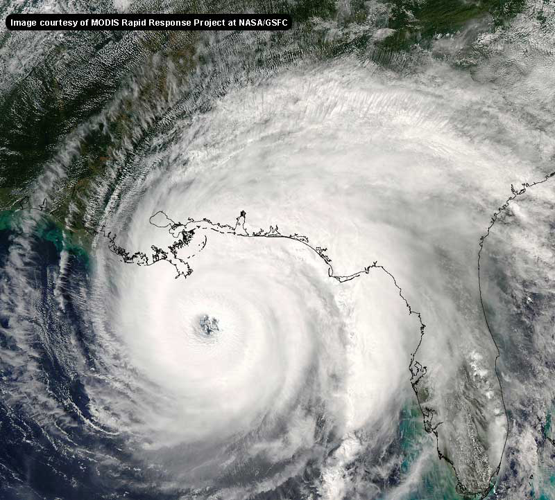
The sat. pictures are impressive. It keeps growing in size. Impressive to see the outer clouds touching Florida, Cuba, and the Yucatan.
This is a very cool site, and I've enjoyed reading the discussions.
Edited by Sneakbridge (Sat Aug 27 2005 10:30 AM)
|
Random Chaos
Weather Analyst

Reged:
Posts: 1024
Loc: Maryland
|
|
Guess what? Navy 's taken their normal track graphic off and stuck up a model track graphic!
http://www.nrlmry.navy.mil/tc_pages/ATL/12L.KATRINA/ssmi/gif/full/Latest.html
They identify the tracks at the ends, and they don't look good for NO. I have to say, there are some models that has put up on the graphic that I've never heard of before. Perhaps internal Navy models?
Edited by Random Chaos (Sat Aug 27 2005 10:26 AM)
|
susieq
Weather Watcher
Reged:
Posts: 49
Loc: Panhandle
|
|
Katrina is surely looking ragged now. Could it be a permanent trend?
--------------------
Gulf Breeze girl still not over Ivan
|
SirCane
Storm Tracker

Reged:
Posts: 249
Loc: Pensacola, FL
|
|
notice how the clouds are starting to be pulled North. Possible that a turn may be taking place?
--------------------
Direct Hits:
Hurricane Erin (1995) 100 mph
Hurricane Opal (1995) 115 mph
Hurricane Ivan (2004) 130 mph
Hurricane Dennis (2005) 120 mph
http://www.hardcoreweather.com
|
FunkyLamb
Registered User

Reged:
Posts: 4
Loc: New Orleans, LA
|
|
The eye is still showing up on Key West long range radar. Two observations.
1) To me, it still looks like its moving 270.
2) Am I crazy, or does it seem like there are two eye walls forming?
11am update will be the deciding factor for metro NO.
--------------------
FunkyLamb
I'm just a simple man trying to make my way in the universe.
|


 Threaded


