Ed Dunham
Former Meteorologist & CFHC Forum Moderator (Ed Passed Away on May 14, 2017)
Reged:
Posts: 2565
Loc: Melbourne, FL
|
|
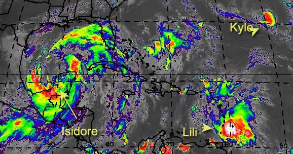
Tropical Storm Isidore spent most of the day completing a cyclonic wobble over the Yucatan but in the past couple of hours he hints at a northeast movement. The overall cloud structure has changed from an east-west orientation to a north-south orientation - which tells me that an eventual movement to the north may slowly get underway. The convective core is long gone and should the cyclone finally get back into the Gulf - and I think that it will - it will take awhile for that core to rebuild. Remember, over water the storm develops the as it grows in intensity. Low pressure doesn't mean instant success - it just means that the system has a better chance of success in the rebuilding process. Isidore may only grow to a shadow of his former self, especially if he starts to speed up, but Cat II certainly seems reasonable. Fast moving tropical cyclones seldom intensify much.
Where will Isidore go? Who knows! Probably further east than originally projected - the atmosphere has changed a bit since Izzy first made landfall. Speaking of projections, the landfall certainly wasn't (except for a crazy looking run which we all ignored). My point is that the models are not the gospel - they certainly missed the southward movement - use them cautiously and listen closely to your local met office or your local broadcast met that you trust (unsolicited plug for Greg and Jason  ) Why hasn't Isidore moved? Easy - zero steering currents. The total circulation envelope of the cyclone is so huge that the only current currents (ah, what a double!) are the cyclones' circulation itself. If it's own upper air pattern alters enough it will likely start an eventual movement to the north - if not, well tropical cyclones do meet their demise over land. ) Why hasn't Isidore moved? Easy - zero steering currents. The total circulation envelope of the cyclone is so huge that the only current currents (ah, what a double!) are the cyclones' circulation itself. If it's own upper air pattern alters enough it will likely start an eventual movement to the north - if not, well tropical cyclones do meet their demise over land.
Tropical Storm Lili - finally! Actually I've had this system at tropical storm strength since about 2pm yesterday afternoon. may have been a little too cautious with this system. Satellite imagery said 'TS', and since a TD was already underway, you can't always wait on an aircraft report - but enough of that. From a meteorological perspective Lili looks like she has gotten her act together. What scares me is that my 72 hour position and the 72hr position match - exactly! St Lucia is next in her sights (one of my favorite Caribbean islands - worth going to if you get a chance).
Where will Lili go? So far, this one is a lot easier than Isidore. Clips Haiti - crosses Cuba - pay attention in south Florida. If it moves further west, then Jamaica could get hit again - they sure don't need that - crosses western Cuba - pay attention in southwest Florida. Expect Lili to reach hurricane strength within 24 hours, and nothing much to weaken it until it hits Cuba. Right now it looks like Puerto Rico is okay, but that does not mean to ignore it. This is a bit of a stretch (timewise), but probably a Sunday event for Florida - more track details later on in the Storm Forum. Keep in mind that Kyle is part of the steering problem. As he slowly intensifies and drifts southwestward, his circulation is helping to reinforce the ridge to his southwest - not much, but a little.
If you live along the Gulf coast or the Southeast coast, keep your eyes on this dynamic duo.
Cancun, Mexico Radar
NRL Monterey Marine Meteorology Division Forecast Track of Active Systems (Good Forecast Track Graphic and Satellite Photos)
NASA GHCC Interactive Satellite images at:
North Atlantic Visible (Daytime Only), Infrared, Water Vapor
Some forecast models:
NGM, AVN, MRF, ETA ECMWF
DoD Weather Models (NOGAPS, AVN, MRF)
AVN, , , , , UKMET
Multi-model plots from WREL
Other commentary at Mike Anderson's East Coast Tropical Weather Center, Robert Lightbown/Crown Weather Tropical Update Accuweather's Joe Bastardi, Hurricane City Weather Audio Broadcast Network - Live Audio from Jim Williams and Barometer Bob , mpittweather , Tropical Weather Watchers.Com (JasonM) Gary Gray's Millennium Weather, Barometer Bob's Hurricane Hollow, Snonut, Ed Dunham and Jason M in our Storm Forum Even more on the links page.
- [ Ed Dunham ]
Edited by MikeC (Mon Sep 23 2002 11:04 PM)
|
mp3reed
Verified CFHC User

Reged:
Posts: 16
Loc: Abilene, Texas USA
|
|
Very thorough SITREP.
|
Anonymous
Unregistered
|
|
I really am having a hard time locating the circulation center of Lili. loops and IR loops show strong convection but i have trouble seeing the low level turning. Seems to me she is getting lifted NW. This could, of course be that she is a small closed ow now. Anyone know the exact location. Izzy getting off Yucatan soon, should follow the prescribed track. has a scary scenario for cuba and Florida as well as Haiti. One rule of thumb i stick to usually. WHere the storm is shown in the models to go, is where it won't. So I feel safe here in East Central Florida....until further notice. Fare thee well on the Northern Gulf Coast!!! God be with you!! Cheers!! Steve H.
|
wxman007
Meteorologist
Reged:
Posts: 617
Loc: Tuscaloosa, AL
|
|
My estimate is about 310-330 motion right now....looks like it is really beginning a move...
--------------------
Jason Kelley
|
Anonymous
Unregistered
|
|
Jason are u talking about Izzy? It needs to move pretty soon if it wants to do any more then just die.
|
Anonymous
Unregistered
|
|
Looking at the latest infra & Wv loops it appears that Lili is moving north, and so is Izzy. What do you think that will do for the forcast of Lili? East Coast maybe??
|
Frank P
Veteran Storm Chaser
Reged:
Posts: 1299
|
|
Models has shifted eastward.... as Jason predicted...
Basically all four models from the have Izzy off the mouth of the MS river in 48 hours.... And guess what, some are predicting a MS coast impact "CAN YOU IMAGINE THAT" and from a Cat 1
http://twister.sbs.ohio-state.edu/text/tropical/atlantic/models/02092400
on a related note, I am selling the Biloxi back bay bridge this weekend... any and all offers will be considered...
|
Justin in Miami
Storm Tracker
Reged:
Posts: 269
Loc: Ft. Lauderdale, Florida
|
|
are there any graphics for the new model runs?
|
Anonymous
Unregistered
|
|
I cant get the loops to work can someone tell me if izzy is starting or is gonna start making a definitve move to the north or wherever.
|
HanKFranK
User

Reged:
Posts: 1841
Loc: Graniteville, SC
|
|
isidore.. not moving much as far as i can tell. i'd still call it quasi stationary. isidore didnt pick the greatest place in the world to stall, for its own sake. another few hours without movement and the center may try to reform. of course there is still plenty to this thing at the mid levels right now and that would be a difficult process.
lili.. youre having a hard time tracking it because the center is outrunning the convection, has been since late this morning. i'd put the center around 63.5w right now. it's trying its damndest to commit suicide. maybe another center will form back under the convection.. as seemed to happen yesterday. i'm still not sold on its survival.
HF 0142z24september
|
joepub1
Storm Tracker
Reged:
Posts: 240
Loc: Jacksonville,Fla
|
|
They show Lili getting tangled up with Haiti/DR and starting to slow.
|
Frank P
Veteran Storm Chaser
Reged:
Posts: 1299
|
|
I just got through watching the IR loop and I couldn't detect any real movement...
|
troy2
Storm Tracker
Reged:
Posts: 227
Loc: cocoa beach
|
|
Frank
I will give you a $.99 Checkers Chicken Sandwich and all the notes to my Mass Media Research Test next Tuesday (dealing with Quantitative and Qualitative research) and one of my (5) 2 liters of Moubtain Dew from my Izzy supplies for that bridge..
let me know! good bridges are hard to come by!
|
Londovir
Weather Guru
Reged:
Posts: 112
Loc: Lakeland, FL
|
|
Justin,
I'm not sure how recent these plots are, or whether they reflect the data everyone's talking about, but it's there for you to check out:
Izzy Model Plots
Jay
--------------------
Londovir
|
Frank P
Veteran Storm Chaser
Reged:
Posts: 1299
|
|
Sold to the highest bidder...... one large bay bridge.... hey, I'll throw in some models runs with it just to sweeten the deal..
Troy, just give me the chicken sandwich and Mountain Dew... you can keep the notes... My college days are over......
|
Anonymous
Unregistered
|
|
IZZY LOOKS TO BE TRYING TO FEED HIM SELF COULD BE VERY CLOSE TO THE GULF I THINK IT WONT TAKE MUCH WHEN HE DOES TO TAKE OFF AND COULD GET STRONG FAST
|
troy2
Storm Tracker
Reged:
Posts: 227
Loc: cocoa beach
|
|
Frank,
Sounds like a deal. Keep the model runs though.
Now a model on a trampoline, thats a different story!
|
troy2
Storm Tracker
Reged:
Posts: 227
Loc: cocoa beach
|
|
HF
a few hours ago I would have agreed with you on Lili. But, I think either a) the LLC has slowed and finally allowed the upper circulation to catch up or b) a new LLC has formed under the mass of convection and upper circ.
On the lasted up close loop i cant make out the circulation at
63.5. What looks like the complete syatem at about 61.5 or so seems to have impressive outflow. Of course recon will paint a more precise picture. When is recon heading there? anyone now?
Troy
Edited by troy2 (Mon Sep 23 2002 10:13 PM)
|
rickinmobile
Unregistered
|
|
cat 3-4 at landfall....
|
Anonymous
Unregistered
|
|
rick when is izzy gonna come back over water? an what about us folks in pensacola what do u have to say?
|


 Threaded


