MikeC
Admin
Reged:
Posts: 4635
Loc: Orlando, FL
|
|
11PM Update
Earlier reports were wrong. Both the 57mph gust... and the NE movement and changing of the hurricane watch.
Navarre is also receiving lots of flooding as is many areas near there.
10:20PM Update
New Orleans reporting winds at NE at 57 mph / 91.7 km/h with gusts to 69MPH.
Earllier mention of motion change in Isidore may be incorrect...
9:30 PM Update
Hurricane Watch extended east to Pensacola... Recon reports isidore moving NE now toward Mobile...
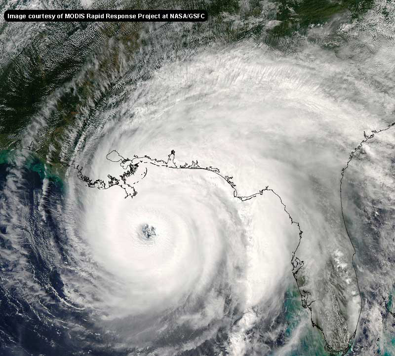
Tropical Storm Isidore shows signs of trying to reorganize near the center now, which may boost it to Cat 1 status before landfall. Folks in the area are getting tremendous flooding rains (and to show you how big this storm is, we are getting rain here in Orlando from it also).
Lili is holding on, despite getting torn up a bit. We'll have to watch this one toward the weekend. And Kyle, now a hurricane still there, will hold probably as a minimal hurricane.
Thanks for those in the Central Gulf for giving us updates on Isidore. Good luck to you all, and stay dry!
Apologies for the front page strangeness. It is getting overloaded with data for the advisories. I haven't found time to rewrite the rather complex system handling it. (I know what the problems are)
NRL Monterey Marine Meteorology Division Forecast Track of Active Systems (Good Forecast Track Graphic and Satellite Photos)
NASA GHCC Interactive Satellite images at:
North Atlantic Visible (Daytime Only), Infrared, Water Vapor
Some forecast models:
NGM, AVN, MRF, ETA ECMWF
DoD Weather Models (NOGAPS, AVN, MRF)
AVN, , , , , UKMET
Multi-model plots from WREL
Other commentary at Mike Anderson's East Coast Tropical Weather Center, Robert Lightbown/Crown Weather Tropical Update Accuweather's Joe Bastardi, Hurricane City Weather Audio Broadcast Network - Live Audio from Jim Williams and Barometer Bob , mpittweather , Tropical Weather Watchers.Com (JasonM) Gary Gray's Millennium Weather, Barometer Bob's Hurricane Hollow, Snonut, Ed Dunham and Jason M in our Storm Forum Even more on the links page.
- [mike@flhurricane.com]
Edited by CFHC (Wed Sep 25 2002 11:14 PM)
|
SirCane
Storm Tracker

Reged:
Posts: 249
Loc: Pensacola, FL
|
|
We've had close to 7 inches of rain. Much more is expected. I must say I haven't seen such downpours since Georges in 1998.
Looking on satellite views, it looks like Isidore's East side is building convection and may just wrap around before landfall. We may just have a Hurricane on our hands tonight.
I think Isidore will come in around Miss./AL line. We'll see a NE turn I predict. Could go as far as Pensacola, depending on how far East he turns. It's also possible that he could come in around New Orleans and then bend NE into Miss/AL/FL for a 3rd landfall. :P
Should be an interesting night. This area has had it bad this year. Bertha, Hanna, and now Isidore.
SirCane
--------------------
Direct Hits:
Hurricane Erin (1995) 100 mph
Hurricane Opal (1995) 115 mph
Hurricane Ivan (2004) 130 mph
Hurricane Dennis (2005) 120 mph
http://www.hardcoreweather.com
|
Steve
Senior Storm Chaser

Reged:
Posts: 1063
Loc: Metairie, LA
|
|
We're having massive street flooding in the City. I'm up on Met. Ridge so I'm about 3' up. But I left work just in time (really too late) today. Many major arteries are shut down, and others are several feet under. You can check on updates from New Orleans at:
fox8live.com (running real slow)
theneworleanschannel.com (WDSU NBC 6)
nolalive.com (Time Picayune)
insideneworleans.com (Cox)
Otherwise, there are numerous mandatory evacuations from Grand Isle to Myrtle Grove. It's pretty incredible, and is the most serious flooding we've had since Tropical Storm in (I think) '88. The difference is there's plenty more to come. Basically everywhere outside the levee protection systems in St. Bernard, Plaquemines, Jefferson, Lafourche and Terrebonne are under orders to leave due to tidal flooding. But it's the rain in Orleans and Jefferson. For the urban areas, it's really a developing situation because they're figuring on another possible 10" of rain tonight. That might be high, but it's not gonna get any better anytime soon.
I'll try to get on later and give an update on the city. I'm high and dry - well not dry cause I got Lotsa [tm] beer. Isadore rules.
Steve
--------------------
MF'n Super Bowl Champions
|
Steve
Senior Storm Chaser

Reged:
Posts: 1063
Loc: Metairie, LA
|
|
http://www.srh.noaa.gov/radar/latest/DS.80stp/si.klix.shtml
This is underdone 
--------------------
MF'n Super Bowl Champions
|
mp3reed
Verified CFHC User

Reged:
Posts: 16
Loc: Abilene, Texas USA
|
|
|
Anonymous
Unregistered
|
|
"I think Isidore will come in around Miss./AL line. We'll see a NE turn I predict. Could go as far as Pensacola, depending on how far East he turns. It's also possible that he could come in around New Orleans and then bend NE into Miss/AL/FL for a 3rd landfall. :P "
And STILL no extension of the hurricane watch area over our way ! Needless to say, if they wait until 2am (or even 11pm) to issue those warnings, it's going to catch a lot of procrastinators off guard. I can't tell you how many people I've talked to today that have done literally NOTHING in preparation because it's "ONLY" a tropical storm warning and not a hurricane watch/warning. Sooooo, I hope that 1) it doesn't strengthen 2) it doesn't turn any to the NE and 3) catch  all the dummies off guard !! all the dummies off guard !!
|
HanKFranK
User

Reged:
Posts: 1841
Loc: Graniteville, SC
|
|
izzy's probably 12 hours from landfall. crunch time, any last minute strengthening could still get it up to minimal hurricane, and break the cycle. there is some convection north of the center, and tons of subsidence cutting around the center from the west. adds to the baroclinic character isidore has been showing. still going with houma, borderline hurricane at most.
lili continues to burst convection and have its center repeatedly jump out to the west and then reform. has been predicting shear to stop mangling the system for about two days now, yet it still keeps ripping away. lili appears to have gained a little latitude today with its jumpy and slower westward motion. if this doesnt kill itself it will end up meandering near florida/cuba/bahamas early next week.
kyle is hurricane, according to the . like i needed them to tell me. official track turns it south and even southeast after 48hrs.. and starts weakening it. low confidence i reckon, should meander after 48 or so, maybe all weekend. still think this will be coming westward next week if it survives.
a small low has formed east of virginia.. with some limited convection. this was a coastal storm represented on models to lead isidore.. doubt it will try anything, but it is over warm enough water in a developing baroclinic environment..
out near 23/41, moving north there is still that old wave that was turned north behind lili. it should turn east beneath the deep low near the azores.. shear is lightening. dont expect anything.. but still keeping an eye on it.
african waves significantly weaker and probably not getting another cape verde system this year.. place shuts down about now usually.
in the long range.. west caribbean and BOC may have frontal tails that get left behind and caught under ridging during the next couple of weeks. it's the time of year for those things to happen.
HF 2240z25september
|
turkeyman
Registered User
Reged:
Posts: 8
Loc: Picayune, MS
|
|
Where did all the people go Steve? Night before last there were bunches of posts. Now it seems everyone is not interested now that LA gets the storm predicted We've had a lot of rain today also. Haven't checked the guage though. My neighbor works for the NWS in the Slidell and keeps an official reading at all times. He's also good on updates and different weather patterns affecting hurricanes. I've been interested since Camille. When you've seen the biggest, these smaller ones just don't meet the mustard. I always keep saying, "Wonder when it's going to get bad?" At any rate, keeping an eye out for them high cloud tops that breed them tornados.
|
Anonymous
Unregistered
|
|
izzy looks to be turning n/e plus lions said last few frames looks to be moving n/e what do you see storm team
|
Southern4sure
Weather Guru

Reged:
Posts: 121
Loc: Land O Lakes, FL
|
|
VERY wet, wind is blowing....streets flooding, lots of area closings. Surf at Gulf Shores reported at 10 ft!
And it is predicted to get worse.
Southern
|
Anonymous
Unregistered
|
|
the tornados are here. jason is tracking 3 and maybe a forth.
|
wxman007
Meteorologist
Reged:
Posts: 617
Loc: Tuscaloosa, AL
|
|
Just a quick update...
We have had at least one confirmed tornado in Walton Co (Destin/Sandestin area) with lots of tree and structure damage...In Santa Rosa Beach a mobile home is lying in the middle of a street, and no one can identify where it came from...We have also had about 4 other possible ones...I have just wrapped up about 2 hours of long-form tornado warning coverage...barely got the Isidore info in the 5 news due to all the local severe weather.
Gonna be a looooooong night here...
--------------------
Jason Kelley
|
andy1tom
Storm Tracker

Reged:
Posts: 309
Loc: Callaway, Florida
|
|
that was me with the post before jason didn't log on
|
Anonymous
Unregistered
|
|
So Jason where do u think the storm will finally make landfall? and how stong do u think it may get or will it stay the same strength it is now? Im here in Gulf Breeze an getting tons of rain. Wonder how strong the winds will be in the morning?
|
RickinMobile
Unregistered
|
|
rain, as much as I have ever seen..probably as much as Hurricane Frederic already...and more to come. Joe B. indicated that the hurricane (not yet, I know) would intensify at landfall...maybe so...at any rate...were it to get it's act together...wouldn't it be interesting...a 100 mph wind possible?....who knows...but gusts to that...sure...and tornadoes.
Lilly is looking to skirt underneath...and be another thrill to watch. Kinda fun to track and learn and talk about these things...with no one getting hurt...
excellent posts, everyone....hang in there...and keep dry...I sure am...looking out my garage with the door open....
gonna be a fun night, i think
|
CFHC

Reged:
Posts: 164
Loc: East Central Florida
|
|
If anyone snaps photos of things going on (with a digital camera or scans, etc) can send them here. I have enabled file attachments to messages, so you can send jpg gif or png image files (up to 3000000 bytes) to share. You need to be logged in to do so, however.
|
wxman007
Meteorologist
Reged:
Posts: 617
Loc: Tuscaloosa, AL
|
|
Really busy...some new local development...really briefly, I find not a lot of reason to quibble with , although I think they are still too far west with landfall...
--------------------
Jason Kelley
|
Anonymous
Unregistered
|
|
jason do you see a n/e turn it looks to be if this thing taps la coast then moves n/e it could stay over the gulf loger what do you see
|
Rick in Mobile
Unregistered
|
|
sure look like a last minute intensification going on...New Orleans may get SUPRISED with this one, ya'll...!!!!!
|
Larry
Weather Watcher
Reged:
Posts: 30
Loc: Raleigh, NC
|
|
Good luck Jason - hope your area has no more tornadoes! We were on the edge the path of one when Fran came through Raleigh..... a 4' diameter oak ended up in our living room. Luckily no one was hurt, although my three daughters were in the room at the time.
Your viewers are lucky to have someone as sharp as you to keep them informed.
|


 Threaded


