typhoon_tip
Meteorologist
Reged:
Posts: 576
|
|
Quote:
We here in Southern Alabama are also under a tornado warning until 6:00 p.m. this evening. The Causeway was becoming overcome with water this morning on my way in to work. The wind is up there also. At least for those of us driving SUVs and such. My parents are off of Dog River and they already had half their huge yard under water this morning. Downstairs from where I work (one-half block off of Water Street) they have sand bags in place. This storm is affecting so many people.
Kimberly, God bless and good luck! You are actually under a tornado "watch", which means conditions are quite favorable for tornadic activity. If you should come under a warning, please heed that! It means a tornado is immanent in your local area. There is a bit of a difference between the intended states of alertness with "watch" vs "warning".
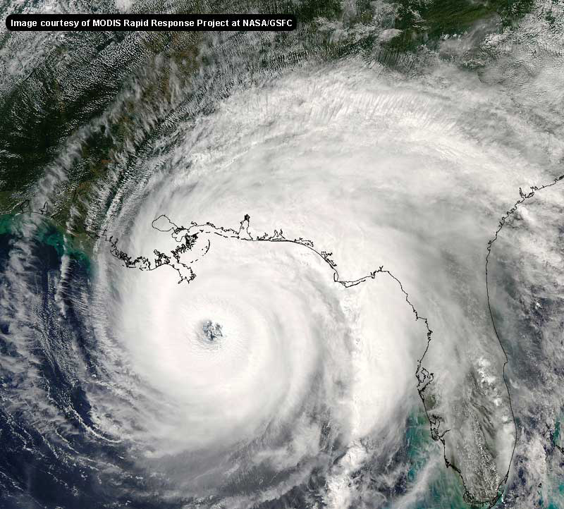
Nevertheless, the entire area of the Upper Gulf Coast, W of the Pensacola is in one way or the other being affected by this tempest. In a way, she is worse for you folks than the prognostics of the earlier days. She's been entraining dry air in gulps over the past 24 hours and this has caused a few mechanical changes in her core..One of which is to expand her wind field to encompass a greater area. This is actually worse for storm weary denizens of New Orleans and other areas of the Louisiana Delta, because otherwise may have meant a storm passing safely SW; close, but still safe. In this situation, (and barring a radical change of heading toward the N which would have to begin right now!), you will still unfortunatley have to contend with tropical storm force wind gust in heavier squalls, which is really akin to pouring salt into a festering wound.
Hopefully you have the ability to stay tuned to your local municipalities and can follow their instructions during the course of this unbelievable indirect attack.
Peace.
|
Rick on boat in Mobile
Weather Drama Guru

Reged:
Posts: 161
|
|
it's a wobble...I think...probably going in where the is saying.
|
rmcinorlando
Verified CFHC User
Reged:
Posts: 14
|
|
Ralphfl - everyone knows that two EYEwitnesses to an event will see things differently. Therefore, other people may see a little differently, depending on what type of map, data, etc. they are viewing. I doubt that you get it right every time. As far as not posting opinions, I don't think that this would be much of a forum if we weren't allowed to do that.
|
ralphfl
Weather Master
Reged:
Posts: 435
|
|
This post was sent to the Hurricane Graveyard
|
pryord1
Weather Watcher
Reged:
Posts: 49
Loc: Navarre, FL
|
|
Look... everyone on this website should know by now that a 1-degree change in any direction makes a 40-50 mile difference in where it goes makes landfall. That shouldn't be news. The point is that we are just trying (key word!) to use our knowledge to discern what MIGHT happen with . Nothing more, nothing less- don't you agree?
--------------------
The key to a good life is higher thought. Challenge yourself, push your personal limits and go for the brass ring!
|
SirCane
Storm Tracker

Reged:
Posts: 249
Loc: Pensacola, FL
|
|
Check out this radar. Definately a jog North taking place.
http://www.srh.noaa.gov/ridge/lix_N0Z_lp.shtml
--------------------
Direct Hits:
Hurricane Erin (1995) 100 mph
Hurricane Opal (1995) 115 mph
Hurricane Ivan (2004) 130 mph
Hurricane Dennis (2005) 120 mph
http://www.hardcoreweather.com
|
tpratch
Moderator

Reged:
Posts: 341
Loc: Maryland
|
|
Ralph, you're starting to be a bit more abrasive. Enhance your calm 
http://www.srh.noaa.gov/ridge/lch_N0Z_lp.shtml
Lake Charles radar is showing an almost perfect 315 degree motion to the eye (due NW). I got out the dry erase markers, my level, my protractor and Everything! 
|
rwjaco19
Registered User

Reged:
Posts: 4
Loc: Charlotte Co., FL
|
|
This post was sent to the Hurricane Graveyard
--------------------
// rwjaco19
|
typhoon_tip
Meteorologist
Reged:
Posts: 576
|
|
Quote:
it's a wobble...I think...probably going in where the is saying.
Hi Rick,
..Of the two technologies, radar will always be clearer as the center of circulation along any given point, and will therefore always be more accurrate in determine true track behavior... pulse and sometimes have mass/fluid dynamical discontinuities which can cause eccentricities as it whirls... Anyway, the following may help clarify some of the "wobble or not" issues as the eye is just coming into range.
http://radar.weather.gov/radar/loop/DS.p20-r/si.klix.shtml
Edited by typhoon_tip (Fri Sep 23 2005 12:37 PM)
|
rmcinorlando
Verified CFHC User
Reged:
Posts: 14
|
|
Yes, I totally agree! Because when it comes down to it, no one really knows exactly where these storms will go. I enjoy reading the various opinions to see if they fall in line with my predictions (which I will keep to myself).
Does anyone know how the evacuations out of Houston are going? I am concerned that some people may become stranded on the road when the storm hits. That would be horrible.
|
Psyber
Storm Tracker

Reged:
Posts: 239
Loc: Ontario, Canada
|
|
Thank god she's slowing down but i fear it held cat 5/4 too long for the storm surge to settle down much. New Orleans is getting an overflow over one of the levees right now but no non-fox generated actual reports of breeching so lets pray they hold!
Edited by RedingtonBeachGuy (Fri Sep 23 2005 01:33 PM)
|
tpratch
Moderator

Reged:
Posts: 341
Loc: Maryland
|
|
http://www.srh.noaa.gov/ridge/lch_N0Z_lp.shtml
The lake charles radar has the entire eye viewable and is likely the better choice (for now) to see the motion. There's one blip of anything approximating N, and even that point is NW of the original one. Give me a moment and I'll show it via graphic.
|
BabyCat
Weather Guru
Reged:
Posts: 150
Loc: New Orleans, La.
|
|
The gov was just on and said the roads have finally cleared enough to drive the speed limit in most places. He also said that in a cpla hours, he is going to ask for copter fly-overs of the evacuated areas to be sure that no one is there who doesn't want to be.
He did get slammed about the failure to open contraflow earlier.
I am in Austin this year (I"m from New Orleans) and the town is at a standstill due to the influx of and now people everywhere.
KHOU does a netcast if you are interested.
|
MadDog
Weather Hobbyist
Reged:
Posts: 51
Loc: DeBary, Florida
|
|
Niel Frank just said that they have not seen the northerly turn that they were expecting. It is still on a NW track.
|
typhoon_tip
Meteorologist
Reged:
Posts: 576
|
|
Quote:
Niel Frank just said that they have not seen the northerly turn that they were expecting. It is still on a NW track.
Which is quite evident by http://radar.weather.gov/radar/loop/DS.p20-r/si.klix.shtml
|
Kimberley Clark
Weather Watcher
Reged:
Posts: 44
Loc: Mobile, Alabama
|
|
And ya know I was trying so carefully to make sure I put "watch" and typed "warning". Sometimes the brain goes into overload. Oh well. Thanks so much for the input. It is sad when you see your neighbors in Bayou La Batre with children still living in tents and being told that they can have their power turned back on only if they sign a waiver that the City is not responsible for loss of life or property. This has been one CRAZY hurricane season. I'm also hoping the tarps on my roof are put back in the correct spot. We lost our home owners' insurance last year after . They gave us $2500 to fix $50,000 + in damages, then let us pay the premium for another several months and sent us a renewal notice saying that unless we had pictures of proof of all the damage fixed, they would not renew. There is no way we could do it. Now, we just have insurance in the Lord. This time, (Katrina) we lost more shingles and more insulation and facier board hanging. We also lost about 7 chestnut trees and two cherry trees in the back yard that broke the water line in three different places and only without power for a week. I consider myself blessed though, truly. I lost no family members and I have a very big family. 13 brothers and sisters and they are all okay. Peace back at ya.
--------------------
Kimberley Clark
Mobile, Alabama
Weather Watcher
|
ralphfl
Weather Master
Reged:
Posts: 435
|
|
This post was sent to the Hurricane Graveyard
|
The Force 2005
Storm Tracker
Reged:
Posts: 299
Loc: Philadelphia
|
|
Psyber,
The levee has breached a 30 ft section of the canal levee. I was just watching on t.v. from CNN Headline News. Water already at waist level in tyhe 9th Ward.
|
ralphfl
Weather Master
Reged:
Posts: 435
|
|
before i go it looks like dry air coming in again to center i hope this drops it below to a cat 3 which no matter where it goes would help alot.the EYE looks very ragged.
|
carolt
Registered User
Reged:
Posts: 5
Loc: Ellaville, FL
|
|
A non_FOX source on levee breeches:
"Our worst fears came true," said Maj. Barry Guidry of the Georgia National Guard.
"We have three significant breaches in the levee and the water is rising rapidly," he said. "At daybreak I found substantial breaks and they've grown larger."
AP report
|


 Threaded


