CFHC

Reged:
Posts: 149
Loc: East Central Florida
|
|
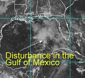
A system...
In the Gulf. Since June 2nd, the tropical weather outlook has mentioned this system in the Gulf, and today, well it still looks as if it won't do much. However, for the time of year it has a fair shot for development.
There are plenty of reasons for it NOT to develop into anything. Definitely not named storm material, but the potential is there to make rain. There will be other opportunities for wave mongering in June. I still don't expect anything to happen until late July. And I'm with Dr. William Gray on the predictions for number of storms.
As to where they will hit. I'm going to say lowest chances are here and the Northeast. Biggest chance is south florida, and the texas coast this year. Middle of the road chances are the central Gulf Coast and the carolinas. Note, this means absolutely nothing!
On my development scale, where is this system?
code: forget it) 0 1 2 3 4 5 6 7 8 9 10 (sure thing)


           [---*------------------]
If it develops, it won't be beyond a depression, and I doubt it'll get that far. It's basically something early to look at to get us warmed up.
Our system for the new is still unfinished, but this i a byproduct of being caught up too much in my day job  . .
NASA GHCC Interactive Satellite images at:
North Atlantic Visible (Daytime Only), Infrared, Water Vapor
Some forecast models:
NGM, AVN, MRF, ETA ECMWF
DoD Weather Models (NOGAPS, AVN, MRF)
AVN, , , , , UKMET
Other commentary at Mike Anderson's East Coast Triopical Weather Center, Accuweather's Joe Bastardi, Hurricane City, Gary Gray's Millennium Weather, Even more on the links page.
- [mac]
|
Steve
Senior Storm Chaser

Reged:
Posts: 1063
Loc: Metairie, LA
|
|
I still think it's 50/50. After I made my prediction, I found that they had done the BAMM/LBAR/ETC model runs last night around 11:30Z. Each of the runs brought the SHIP and DSHP estimates to near TS strength then weakened it by 72 hours back to TD status. In 72 hours, the models went as follows:
BAMD 26.4/91.1(Not far from the initial position of 24.6 90.1)
BAMM 25.9/92.9 (indicated a westerly drift)
A98E 30.7/90.5 (somewhere near Folsom, LA)
LBAR 29.4/91.7 (south of New Iberia)
--------------------
MF'n Super Bowl Champions
|
Greyman
Weather Watcher

Reged:
Posts: 32
Loc: Miami,Fla.
|
|
I could'nt agree with you more,if I had a development scale I would be right on target with yours,and your areas of possible threats to,but I think that the Central Gulf Coast has a better chance that you think,because if a storm threatens South Fla. from east to west those storms usually turn north in the Gulf like an Andrew or Georges type track.
|
ShawnS
Storm Tracker
Reged:
Posts: 226
Loc: Pearland,Tx
|
|
I think everyone along the whole gulf coast needs the rain, so let it come here and everywhere.What I want to know is what needs to happen to make this system come to Texas? We certainly need some action here ,too! 
|
Anonymous
Unregistered
|
|
Tonight looks like a rerun of last night regarding out little disturbed area as the convection apears to be dying down in GOM while it's building some deep convection on the Yucatan Pensula and an area inland just south of the BOC.
Western GOM pressures are just a tad bit lower than that noted in central GOM (1009.5 vs 1010.1). Winds also insignificant tonight in the GOM with max reading of only 17k.
At best we're in a holding pattern with this system. Heck if it hangs around long enough, like till August, it just might develop. 
|
Steve
Senior Storm Chaser
Reged:
Posts: 1063
Loc: Metairie, LA
|
|
Looks like I got fooled by the way things appeared to be coming together earlier yesterday afternoon (- pressure falls). I think the Gulf is still half-way ripe but I doubt anything's going to happen now. Perhaps a system may come together in the EastPac just SW of Mexico, because that seems to be where all the energy is.
Steve
--------------------
MF'n Super Bowl Champions
|
Frank P
Veteran Storm Chaser
Reged:
Posts: 1299
|
|
I forgot to logon last night, post above Steve's was mine. Frank P.
GOM is very quite this morning. Pressures are still a little low in the 1010 to 1011 range, still no wind fields to indicate anything going on .... Guess we'll wait and see if any convection comes back today... Or if the energy in southern mexico and northern central america heads towards the GOM or BOC...
What can I say, its still June....
|
Colleen A.
Moderator

Reged:
Posts: 1432
Loc: Florida
|
|
Morning all! Just took a look at the loops in the Western Atlantic and the GOM. Nothing much going on with the 92L, that's for sure. But it looks as if there is a line of storms from N to S headed into Florida later this afternoon.
A couple of things I noticed also. In the Western Atlantic, just SW of PR and almost due E of Jamaica, there has been a big blow up of convection. I'm not saying anything will become of this, it's just there. Also...Yucatan Channel, there seems to be a lot of twisting and turning there and although the convection has died down somewhat this morning, it was very active earlier. Other storms coming off the Yucatan Peninsula almost drifting due east in the waters.
Whether or not any of these things become "tropical" or not I have no idea of knowing at this point, as I have not yet looked at the shear maps or any other mitigating factors that would inhibit development. Just posting what I see because that's what I do for a living. 
--------------------
You know you're a hurricane freak when you wake up in the morning and hit "REFRESH" on CFHC instead of the Snooze Button.
|
Rich B
British Meteorologist
Reged:
Posts: 498
Loc: Gloucestershire, England, UK
|
|
Ok, the system in the gulf looks pretty poor so far today. Lost alot of its organisation, but there is a 1011 surface low now. It should remain nearly stationary, so with the high temps in the Gulf there is still some potential for this thing to develop. Hoowever, i am not going to be too optimistic with this one, and i dont think we will see anything more than a few disorganised showers and storms.
Rich
StormWarn2000 IWN
--------------------
Rich B
SkyWarn UK
|
Greyman
Weather Watcher
Reged:
Posts: 32
Loc: Miami,Fla.
|
|
Well seems like we are going to have to wait a littlle longer for the first real Tropical Disturbance of the season,that area in the Gulf has really not gotten its act together,allthough conditions should become more favorable during the next couple of days,especially in the western Gulf & Bay of Campeche,but it still a waiting game.
|
Anonymous (HF)
Unregistered
|
|
for what its worth im going to stick with my preseason guess that nothing comes until july. as much as i was doubting it a couple weeks ago, with that big offshore low lighting up the forecast models, its a reasonable bet and probably wont get me into too much trouble. based on how things look right now i would discount any formation in the next four days. of some note is the disturbance south of the gulf of tehuantepec in the eastpac. that could be boris in a day or two.
as for the part about beavers: forget all the cute cartoon images you have in your mind about the varmints. i spent yesterday afternoon in the biggest disgusting mire hacking up three beaverdams that are choking up a creek on the hunting club i belong to, making the pond below it an algal blooming mess. drought and dirty mucky water dont do good things for gamefish populations. also of note: dont walk on quivering sphagnum moss and submerged peat with methane bubbles coming out vigorously; there is nothing but cold water below and when you punch through it doesnt want to let you back up. thanks to some evil beavers i discovered this bit of trivia, as well as gaining an uncanny resemblance to swampthing.
|
Anonymous
Unregistered
|
|
CHeck the BOC this morning. Swirl of convection heading WNW....looks like its trying to spin up.....will head towards Mexico. Caribbean (central) to the Leewards also looks juicy. I hate the early season teases...has me checking out everything! Cheers!! Steve H.
|
Greyman
Weather Watcher
Reged:
Posts: 32
Loc: Miami,Fla.
|
|
|
Weather Witch
Unregistered
|
|
 I thought there wasn't a EL NINO this year. I thought there wasn't a EL NINO this year. 
|
Greyman
Weather Watcher
Reged:
Posts: 32
Loc: Miami,Fla.
|
|
Well there is, its been developing slowly since November of last year.Not expected to be a big one,but never the less its there.
|
Anonymous
Unregistered
|
|
Appears to be a weak circulation around Jamaica. Any thoughts?
|
Steve
Senior Storm Chaser
Reged:
Posts: 1063
Loc: Metairie, LA
|
|
According to some of the models @ PSU's Tropical Genesis potential, South Florida appears to be the next trouble spot.
AVN has some action over the southern tip @ 120 hours.
MM5-135km & -45km have something over Cuba @ 72.
Good luck!
Steve
--------------------
MF'n Super Bowl Champions
|
Greyman
Weather Watcher
Reged:
Posts: 32
Loc: Miami,Fla.
|
|
Yes Steve,the AVN sure does indicate that there is some kind of low pressure over the souther tip of Fla. thru the 120 hr. period and there does appear to be a cirrculation near Jamaica accompanied by a blow up of showers & T-Storms,it will be interesting to see what happens over the next few days.
|
Steve
Senior Storm Chaser
Reged:
Posts: 1063
Loc: Metairie, LA
|
|
Greyman,
It sure will be. That's a nice little Blob of Convection [tm]. But the Gulf is currently ringed with what appears to be an Upper Level High. Storms were in South LA wrapping all the way around FL today. I don't know where this high might be headed because it's just kind of materialized after the ULL moved out mid-week.
Steve
--------------------
MF'n Super Bowl Champions
|
Anonymous (HF)
Unregistered
|
|
far as i can tell the spin in the caribbean is an upper low with plenty of surface convection nearby. nothing that menacing in the basin tonight. the models as usual are feeding us cause to wave monger. still a lot of shear out there.
over in the eastpac there is less hesitation for development.. a pretty good disturbance is moving along the mexican riviera. pretty good odds it will be boris over the weekend, and with its slow progress it is a flood threat. be interested to know what the normal pattern is during a neutral to slightly warm year when the eastpac season kicks off in earnest.
|


 Threaded


