Local
Unregistered
|
|
aka: Beach
Like I said yesterday morning.
It wouldn't suprise me if passes Jamacia to the North
cutting through Central or Eastern Cuba.
|
Wxwatcher2
Storm Tracker

Reged:
Posts: 337
Loc:
|
|
Judging from the Satellite pictures only, I agree that is staying on the Northern edge of the forecast track. I'm not sure what this means a few days out but I would make a future track noticably more to the East if a weakening in the ridge should occur.
Glad to see everyone onboard and monitoring this one. Let's see where we are Monday morning. I think we'll know a lot more by then.
|
SirCane
Storm Tracker

Reged:
Posts: 249
Loc: Pensacola, FL
|
|
Go Auburn!  I'm just hoping stays a smaller storm no matter how strong it gets. I don't want to see another or that hurts a large area. was a small Hurricane so the damage was limited to a smaller area. That would be better. I'm just hoping stays a smaller storm no matter how strong it gets. I don't want to see another or that hurts a large area. was a small Hurricane so the damage was limited to a smaller area. That would be better.
--------------------
Direct Hits:
Hurricane Erin (1995) 100 mph
Hurricane Opal (1995) 115 mph
Hurricane Ivan (2004) 130 mph
Hurricane Dennis (2005) 120 mph
http://www.hardcoreweather.com
|
RevUp
Weather Guru
Reged:
Posts: 181
Loc:
|
|
Yesterday I suspected that #5 (Ernesto) would be a lot worse off - it's held together remarkably well. That being said, any speculation about the Gulf is just that. Jamaica is under the gun once again and west Cuba after that. As exhibited in the changes since yesterday, there is still a lot of variability in the model output once this thing reaches the Gulf (could even stall in the central Gulf for a couple days!). It's going to be one wild ride over the next week.
--------------------
"Let tomorrow worry about itself. Each day has enough trouble of its own."
|
nc_tropical_wx79
Weather Guru

Reged:
Posts: 123
|
|
from looking at the short wave loop it would almost appear that the COC has reformed further E in the heart of the
This is possible in response to the shear impinging the W flank
Anyone have a view on this ??
--------------------
W.D. Duncan
|
TampaRand
Weather Hobbyist

Reged:
Posts: 76
Loc: Tampa FL
|
|
From my first blog this morning:
Ernesto has survived and strengthened during the night. The system faced heavy shearing winds and those winds are now in retrograde from an Upper Level Low to the west, which is now moving west. The last model runs are indicating a CAT 3-4 event with eventual landfall somewhere around Panama City FL to Pensacola. The official track remains substantially unchanged from last night. The track usually exhibits errors around 220nm per day, so I would not get to interested in the "where" at this point. The trending for recurvature is something I commented on a while back, seeing a lessening of a ridge of High Pressure that will move ENE late in the forecast. I still believe that to be true and the models are responding to that also. I was seeing this trend looking at some of the 192 hour models and see no reason to change that right now. The convection in the storm appears to be wrapping around the LLC and central pressure is dropping now to 997 Mb, but there is still a moderate level of shear to the west of the system preventing it from a full wrapup of convection. When that happens the central core of the storm will develop rapidly. Yesterday at this time the Center of Low Pressure was outrunning the convection due to the shear, but that is lots less pronounced today. Make no mistake, the northern Gulf Coast is at great risk, especially the panhandle of FL to New Iberia, LA. There are still some challenges this storm faces like a possible move across the Cuban mountains and other land interactions, but when it enters the Gulf, the only thing it will face is extremely warm water to throw gas on the fire. Needless to say, TODAY is no better day to make early preparations if you believe yourself to be at risk. There is time to prepare. Stay aware and prepare!
--------------------
Amateur Weather Prognosticator and Cane Junkie.
www.hurricanewx.net
|
madmumbler
Storm Tracker

Reged:
Posts: 324
Loc: SWFL
|
|
Quote:
ALthough Tampa Bay usually does not end up in the cone of insanity, I am already ready. I have three bags of Cat littler in my car trunk, and I plan to get gasoline this week before the prices sky=rocket next week. I will have to drive conservatively in order to maintain a 3/4 tank so that I can go most any place in Florida without having to find gasoline. The shelves have been stocked and I found out what my family likes out of the first set of supplies I bought, *they can not refrain from trying them out each season, so I learned to bring home a little and then if they like it, go buy more and hide it.*
So I really need to buy one more small animal carrier to accomodate the six cats who are placed in the carriers when our County is under hurricane warning within 3-4 hours. It makes life more comforting for them and me. So praying that the ULL gets it and brings on a summer shower only. This is the last post I will make on this subject so that the experts can bring us the most important information.
Cone of insanity -- hand't heard that one, but I like it!
It's still too soon to tell how this will turn. So far, the path hasn't been creeping closer to FL, but that can obviously change. I'm hoping it's going to stay west of the west coast, which isn't good news for everyone else, but as you said would just bring us gusty wind and rain, nothing major. It could however, depending on how close to the coast it comes, bring us higher than normal tides, possibly tornados.
Again, it's still too soon to tell.
--------------------
Lesli in SWFL.
Friends help you move. Real friends help you move bodies.
|
madmumbler
Storm Tracker

Reged:
Posts: 324
Loc: SWFL
|
|
Quote:
Not sure what to make of my observation; Since at least 30 hours ago, the official location of the storm has been at the northern most model prediction point for that update, or just north of all the animated model plots, each and every time. Is it fair to extrapolate this to the future path, and stick to the models that favor a right bias to the storm path? Something like, the storm crossing Cuba not at the west tip, but more east, and bending towards Florida. Well, just an observation, and question. Any way you cut it, looks like this storm will bring problems to too many folks, just a matter of who, and that SU-KS!
It will bounce back and forth for a while. Until it gets to around Cuba, the path is going to be hard to tell. taught us that. Even then if it's close to FL, it could be hard to tell.
The larger it gets, the easier it will be to tell where it's going at that point, because the smaller storms get buffeted around more easily, or sucked up harbors (aka *LOL*). The bad thing is, it would be a larger storm.
I have a feeling from what I'm seeing that it may get to be a larger storm.unless the shear can hold out long enough to keep knocking it back. Which I don't think is going to happen.
--------------------
Lesli in SWFL.
Friends help you move. Real friends help you move bodies.
|
TampaRand
Weather Hobbyist

Reged:
Posts: 76
Loc: Tampa FL
|
|
Yes, the shear is defintely receding from the ULL movement west. This storm is starting to really get it's act together. I was just looking at the shortwave imagery and water vapor. It's actually a pretty good looking storm right now and I don't see much to impede it's progress now. It appears to be wrapping up it's convection and has decent outflow, except in the SW quad, which appears to be under some very moderate shear-nothing like yesterday.
--------------------
Amateur Weather Prognosticator and Cane Junkie.
www.hurricanewx.net
|
madmumbler
Storm Tracker

Reged:
Posts: 324
Loc: SWFL
|
|
I was just running through all the GOES floater views, and is it me or does it look like it's pushing a little northward? I'm not sure where the COC is, but that sw-ne flow in front of it, is it bouncing it further north?
I do realize that they will bobble. I'm NOT panicking. *LOL* What I'm trying to determine is this just normal "squishing" of the storm and it's not effecting the track, or is it a wobble, or is it a movement trend starting, OR am I just reading the satellite views incorrectly?
--------------------
Lesli in SWFL.
Friends help you move. Real friends help you move bodies.
|
Hugh
Senior Storm Chaser
Reged:
Posts: 1060
Loc: Okaloosa County, Florida
|
|
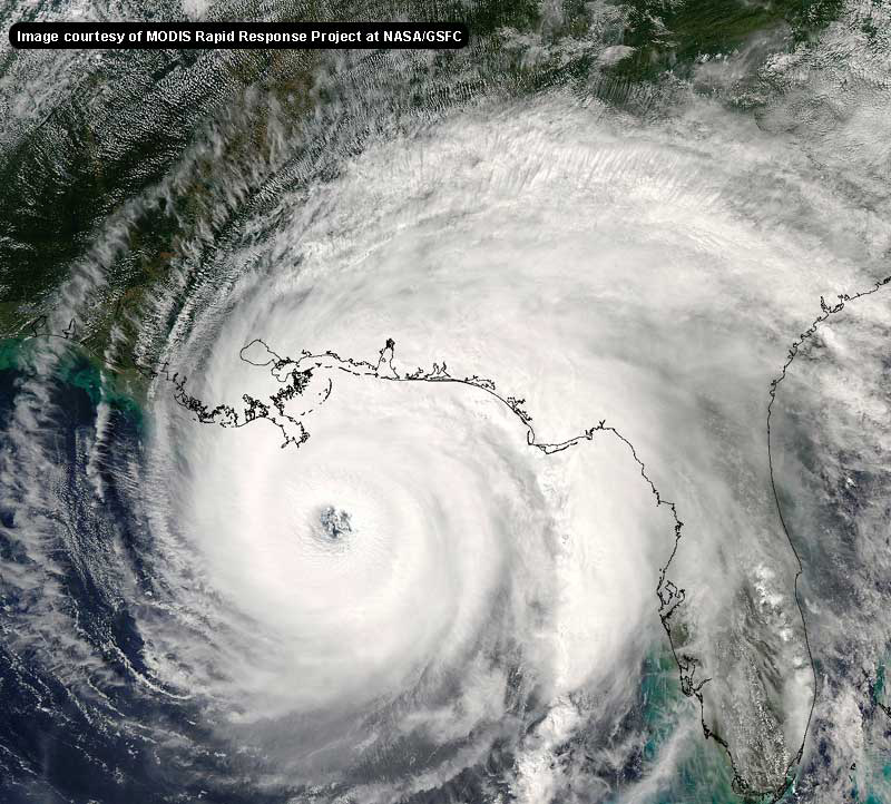
11am Advisory is out... What I consider a significant change in the forecast track in Day 4/5.... whereas at 5am the track was headed west of New Orleans toward Grand Isle (to my eye, anyway), the new track has a decidely -like look to it... with the bullseye on New Orleans.
--------------------
Hugh
Eloise (1975) - Elena and several other near misses (1985) - Erin & Opal (1995) - Ivan (2004)
|
EugeneF
Registered User
Reged:
Posts: 9
|
|
New 11am EDT advisory up 20 minutes early...
Note that this information can be found on the Main Page...
Edited by Storm Cooper (Sat Aug 26 2006 02:48 PM)
|
zacros
Weather Hobbyist

Reged:
Posts: 57
Loc: Johns Island, SC
|
|
Interesting low pressure forming off of the SC/GA coast today. Weather in Charleston has been rainy for the past two days, not it looks like a low is forming. May not amount to much, but the water in the area of the low is in the upper 80s. Looks like the low is forming along the frontal boundary that extends out toward Bermuda. Swirl is clearly evident on the Long Range Rader and on the visible satellite loop. Will anything develop out of this?
|
TampaRand
Weather Hobbyist

Reged:
Posts: 76
Loc: Tampa FL
|
|
Not only that, but there is an anticyclonic ridge beginning to form above This does not bode well for any lessening of this system. It's looking very favorable for a major cane at this point.
The storm off SC is a feature I have been keeping an eye on, but not excited yet. Also Africa shot off another pretty good looking wave in the last 12 hours, but that is way early to get excited about.
--------------------
Amateur Weather Prognosticator and Cane Junkie.
www.hurricanewx.net
Edited by TampaRand (Sat Aug 26 2006 02:56 PM)
|
pcola
Storm Tracker

Reged:
Posts: 344
Loc: pensacola/gulf breeze
|
|
NHC is buying into the global models..and moving the track 5 days out farther east...looking more and more like the central and eastern gulf will be under the gun..Dr Lyons made this observation this morning also..hope things chank..i would like to get Clarks take on the globals and the weakness in the ridge
--------------------
Erin 95 , Opal 95, Ivan 04, Dennis 05, and that's enough!!!!
|
TampaRand
Weather Hobbyist

Reged:
Posts: 76
Loc: Tampa FL
|
|
Yep, with good reason. I think there's some early convergence that's very good,but started trending that early and responded also. Look at that ridge about 96 -120 hours and you'll see what I've been saying and the models have been trending.
--------------------
Amateur Weather Prognosticator and Cane Junkie.
www.hurricanewx.net
|
Lysis
User

Reged:
Posts: 451
Loc: Hong Kong
|
|
The variability here is already stifling... as usual!
Forgive my ingnorance, but a quick question: How does intensity (that is, intensity of the cyclone, not the ridge) translate into the eventual track of as it begins to recurve? Just in terms of simple interaction, a stronger storm bodes worse for those in the east?..west?
Thanks.
Edited by Lysis (Sat Aug 26 2006 03:11 PM)
|
Kevin
Weather Master

Reged:
Posts: 524
Loc: EC Florida
|
|
Quote:
The variability here is already stifling... as usual!
Forgive my ingnorance, but a quick question: How does intensity (that is, intensity of the cyclone, not the ridge) translate into the eventual track of as it begins to recurve? A stronger storm bodes worse for those in the east?
Thanks.
On a very basic level, stronger storms tend to "feel" more of what is going on in the upper-levels of the atmosphere. So, stronger storms (tropical cyclones) are more susceptible to changes in steering patterns. Changes in the upper-levels tend to be more pronounced for strong hurricanes than for week ones. If was forecast to remain a weak tropical storm thorugh the forecast, it is unlikely that any official forecast would show it making a sharp curve.
Clark could offer you a more precise, technical description.
|
Kevin
Weather Master

Reged:
Posts: 524
Loc: EC Florida
|
|
Quote:
NHC is buying into the global models..and moving the track 5 days out farther east...looking more and more like the central and eastern gulf will be under the gun..Dr Lyons made this observation this morning also..hope things chank..i would like to get Clarks take on the globals and the weakness in the ridge
The is still a good deal left of the global consensus. If the agreement between the global models continues, then will need to shift the track even more the right.
|
Mike Gaynor
Unregistered
|
|
Deleted by Moderator
Edited by Storm Cooper (Sat Aug 26 2006 04:02 PM)
|


 Threaded


 I'm just hoping


