TS2
Verified CFHC User
Reged:
Posts: 19
Loc: Orlando, Florida
|
|
I will be posting info on the Cyclones that i think were most Notable.
Here is my 1st entry: Super Typhoon Tip
Typhoon Tip is considered to be the most intense and largest tropical cyclone ever recorded. The cyclone formed on October 5, and after moving into a very favorable environment for development, quickly strengthened into Super Typhoon Tip on the 11th. On the 12th, Super Typhoon Tip continued to intensify, with winds at 190 miles per hour and central pressure at 870 millibars, the lowest barometric pressure ever recorded from a tropical cyclone. Tip ultimately hit Japan, causing 68 deaths and moderate damage. It dissipated on October 19.

Super Typhoon Tip at peak size and strength.
As a result of very favorable conditions for development, Typhoon Tip rapidly intensified in the open waters of the western Pacific Ocean. Late on October 10, the typhoon attained the equivalence of a Category 4 hurricane on the Saffir-Simpson Scale, and the next day it became a super typhoon. The central pressure dropped 92 mbar (hPa) from October 9 to 11, during which the circulation pattern of Typhoon Tip increased to a record diameter of 2220 km (1380 mi). The typhoon continued to intensify further, and early on October 12 Reconnaissance Aircraft recorded a world record-low pressure of 870 mbar (hPa) with winds of 305 km/h (190 mph) while located about 840 km (520 mi) west-northwest of Guam. At the time of its peak strength, its eye was 15 km (9.3 mi) wide.
After peaking in intensity, Tip weakened to a 230 km/h (145 mph) typhoon and remained at that intensity for several days as it continued west-northwestward. For five days after reaching its peak strength, the average radius of winds stronger than 55 km/h (35 mph) extended over 1100 km (685 mi). On October 17, Tip began to steadily weaken as its size reduced, and the next day it began recurving northeastward under the influence of a mid-level trough.
After passing about 65 km (45 mi) east of Okinawa, it accelerated its forward motion to 75 km/h (46 mph), and on October 19 Tip made landfall on the Japanese island of Honshu with winds of about 130 km/h (80 mph). The typhoon continued rapidly northeastward through the country and became an cyclone over northern Honshū a few hours after moving ashore. The remnant of Tip continued to the northeastward before losing its identity on October 21 to the east of the Kamchatka Peninsula.
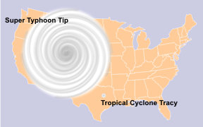
Typhoon Tip was the largest tropical cyclone on record with a diameter of 1380 miles (2220 km), almost double the previous record set by Typhoon Marge in August of 1951. It was also the most intense tropical cyclone on record with a pressure of 870 mbar (hPa), 6 mbar lower than previous record set by Super Typhoon June in 1975.

The relative sizes of the United States, Typhoon Tip and Cyclone Tracy.
--------------------
Dr. Joe Smith
Substitute Teacher at University of Central Florida
GreatWeatherForums
|
|


 Threaded


