TS2
Verified CFHC User
Reged:
Posts: 19
Loc: Orlando, Florida
|
|
Here is my second entry:
Hurricane Mitch (1998)
Hurricane Mitch was one of the deadliest and most powerful hurricanes on record in the Atlantic basin, with maximum sustained winds of 180 mph (290 km/h). The storm was the thirteenth tropical storm, ninth hurricane, and third major hurricane of the 1998 Atlantic hurricane season. At the time, Mitch was the strongest Atlantic hurricane ever observed in the month of October, though it has since been surpassed by Hurricane of the 2005 season. The hurricane also tied for the fourth most intense Atlantic hurricane in recorded history, but it has since dropped to seventh.
Mitch formed in the western Caribbean Sea on October 22, and after drifting through extremely favorable conditions, it rapidly strengthened to peak at Category 5 status, the highest possible rating on the Saffir-Simpson Hurricane Scale. After drifting southwestward and weakening, the hurricane hit Honduras as a minimal hurricane. It drifted through Central America, reformed in the Bay of Campeche, and ultimately struck Florida as a strong tropical storm.

Figure 1: The track of Hurricane Mitch.
The origin of Hurricane Mitch can be traced to a tropical wave that moved off the coast of Africa on October 10. It moved westward across the shear-ridden Atlantic Ocean, and remained disorganized until entering the Caribbean Sea on October 18. Upon entering the western Caribbean Sea, convection steadily increased, and on October 22, the wave organized into Tropical Depression Thirteen while 415 miles (670 km) south of Kingston, Jamaica. Under weak steering currents, it drifted westward and intensified into a tropical storm on October 23 while 260 miles (420 km) east-southeast of San Andres Island
Initially, intensification was limited due to an upper-level low causing vertical wind shear over Tropical Storm Mitch. As the storm executed a small loop to the north, the shear weakened, allowing the system to strengthen. Mitch attained hurricane status on October 24 while 295 miles (475 km) south of Jamaica, and with warm water temperatures and well-defined outflow, the hurricane rapidly strengthened. During a 24-hour period from October 24 to the 25th, the central pressure dropped 52 mbar, and on October 26, Mitch reached peak intensity with 180 mph (290 km/h) winds and a pressure of 905 mbar, one of the lowest pressures ever recorded in an Atlantic Hurricane

Figure 2: IR Image of Hurricane Mitch at peak intensity (155 knots, 906 hPa)
Mitch at Peak Intensity Loop
Figure 3: IR Loop of Hurricane Mitch at peak intensity recorded 26th October.
Because of the hurricane's destruction in Central America and elsewhere in North America, the World Meteorological Organization retired the name Mitch in the spring of 1999; it will never again be used for an Atlantic hurricane. The name was replaced with Matthew in the 2004 season.
My next entry will be tomorrow and it will cover Hurricane (2005)
--------------------
Dr. Joe Smith
Substitute Teacher at University of Central Florida
GreatWeatherForums
Edited by danielw (Sun May 20 2007 08:42 PM)
|
Lysis
User

Reged:
Posts: 451
Loc: Hong Kong
|
|
Well done, and fascinating.
If you would do one on Andrew, I would be most obliged.
--------------------
cheers
|
Hurricane29
Weather Guru

Reged:
Posts: 148
Loc: Miami Florida
|
|
(Hurricane Andrew)
Hurricane Andrew caused an estimated $26 billion damage in the United States making it the most expensive natural disaster in United States history. At landfall in southern Dade County, Florida, the central pressure was 922 millibars, which is the third lowest this century (after the 1935 Florida Keys Labor Day storm and Hurricane Camille in 1969) for a landfalling hurricane in the U.S.
As with many of the worst Atlantic hurricanes, Andrew was born as a result of a tropical wave which moved off the west coast of Africa wave and passed south of the Cape Verde Islands. It became a tropical storm on August 17, 1992 and moved uneventfully west northwestward across the Atlantic. Significant changes occurred in the large-scale environment of Andrew on August 21 as a deep high pressure center developed over the southeast U.S. and extended eastward to north of the tropical storm. In response to the much more favorable environment, Tropical Storm Andrew strengthened rapidly and turned westward.
Andrew became a hurricane on August 22 and strengthened to a strong category 4 hurricane the next day. As it moved westward, it weakened to 941 millibars as it passed over Great Bahama Bank on the 24th, but rapidly re-intensified as it moved over the Gulfstream on its approach to Florida. In fact, the deepening trend continued up to and slightly inland of the coast. (Eye temperatures as measured by reconnaissance aircraft suggest that convection in the eyewall and associated vertical circulation became more vigorous as the storm moved ashore). The storm devastated Dade County where it caused an estimated $25 billion in damage. After striking Florida, Andrew moved northwest across the Gulf of Mexico to make a second landfall in a sparsely populated area of south-central Louisiana as a Category 3 storm on August 26. In total, Andrew directly caused 23 deaths in the U.S. and indirectly caused 38 more. The number of homes destroyed was 25,524 and 101,241 were damaged.
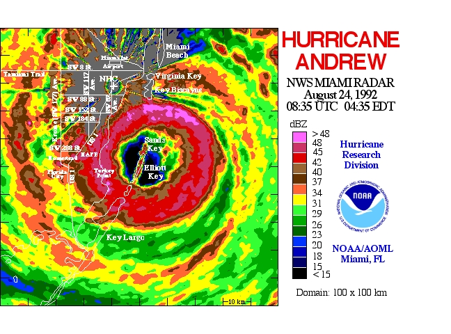
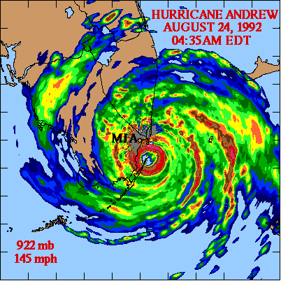
Here are a couple of images of Andrew....
Andrew's eyewall on NWS Miami Doppler Radar-

Radar image at landfall-

Hurricane Andrew on its way to south florida-

Visible image at landfall-

Edited by Hurricane29 (Sun May 20 2007 07:57 PM)
|
|


 Threaded


