Ed Dunham
Former Meteorologist & CFHC Forum Moderator (Ed Passed Away on May 14, 2017)
Reged:
Posts: 2565
Loc: Melbourne, FL
|
|
2AM EDT Update 21 July 2008
Dolly's center has been readjusted and it is now located over Cancun Mexico, which is a good shift (half a degree latitude) north from earlier center fixes. This means it will be over land only very briefly before moving into the Gulf of Mexico. Those in Texas and Northern Mexico need to watch Dolly very closely. 5AM forecast track may be adjusted.
Earlier Update
At 1545Z upgraded Invest 94L directly to Tropical Storm Dolly in the western Caribbean Sea. Dolly is 230 miles southeast of Cozumel, Mexico moving to the northwest at 15 knots with sustained winds of 45mph and a central pressure of 1008MB. Tropical Storm Warnings are up for the east coast of the Yucatan peninsula.

Additional slow strengthening is anticipated before landfall Monday morning in the Cozumel area. The longer range forecast places Dolly at the Texas/Mexican border near Brownsville on Thursday morning as a strong Tropical Storm. Those folks in the northern Mexico - Central and Southern Texas area need to monitor the progress of Dolly closely.
What do you think Dolly will do, the Dolly lounge is now open.
Tropical Storm Cristobal continues to drift slowly northeastward just off the North Carolina coast. Maximum sustained winds remain at 50mph and the central pressure is at 1007MB. Cristobal remained unchanged during the night, however some slight additional intensification is expected. Cristobal should remain just offshore as he heads toward Nova Scotia and gets absorbed by a trough moving off the east coast - in about four days.

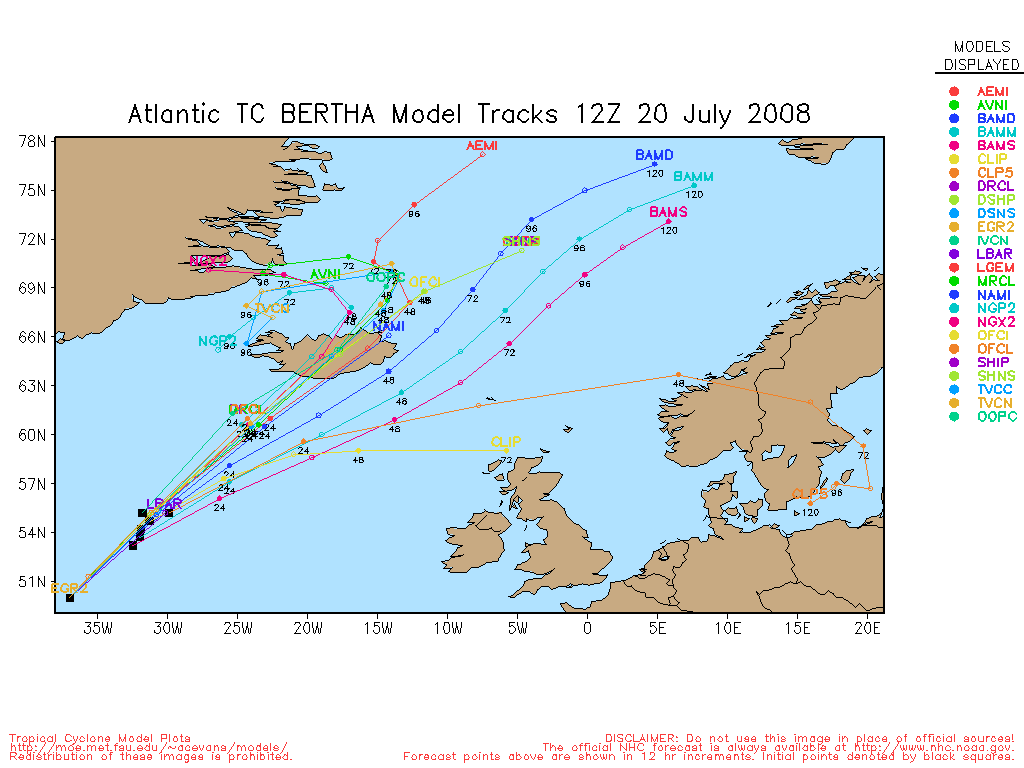
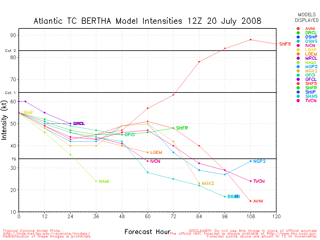
Bertha is now as she races northeastward toward the southern shores of Iceland as a strong gale. The issued its final bulletin on Bertha at 15Z.
A strong tropical wave will move off the coast of west Africa this evening and is worth monitoring for potential development next week.
ED
Event Related Links
Cozumel Weather
Cancun Radar Cancun Radar Loop (Flhurricane long term recording)
Long Term Radar Recording of TD#3 HCWX Level 3 Radar Recording/TD#3
Southeast Radar Composite (loop)
Edited by MikeC (Mon Jul 21 2008 06:06 AM)
|
typhoon_tip
Meteorologist
Reged:
Posts: 576
|
|
RE Cristobal: I mentioned this upon Cristobal's designation that nearby continental dry air mass may become a hindrance should Cristobal attempt to strengthen. believes that to have been the case. In the earlier stages of this system's development, it's circulation field was not as expansive... But as that took place, the dry air at low and mid levels was ingested and that has prevented this system from sustaining deep convection.
John
Edited by typhoon_tip (Sun Jul 20 2008 04:45 PM)
|
danielw
Moderator

Reged:
Posts: 3525
Loc: Hattiesburg,MS (31.3N 89.3W)
|
|
Image below is the JSL enhancement. Notice the white fingers/ fringe around the periphery of Dolly.
This appears to indicate very little wind shear at the upper levels. Which could permit Dolly to strengthen rapidly.
Early morning, 12Z, upper air charts show an upper level high center over the GOM at 200mb or 38000 feet.

|
typhoon_tip
Meteorologist
Reged:
Posts: 576
|
|
RE Dolly: There is a interfering with the deep layer wind profiles, causing some "denting" in an otherwise decent outflow. This is causing a bit of asymmetry in the cloud pattern, as well as preventing a uniform intensification. Until this feature finally disconnects from Dolly's outflow levels, this will likely prevent any period of more profound intensification. That, and Dolly's interaction with the Yucatan Peninsula will keep Dolly from becoming very strong. However, post clearing the peninsula, most large scale dynamical models predict an anticyclone over the BOC/western Gulf, and with amply warm waters in the Gulf there will be opportunity for more discerned development. Of course...none of this is intended to state that Dolly can't become stronger, just that the environment at this time suggests holding her own. Persons along the TX and Mexico coast certainly need to monitor the progress of this system.
Edited by typhoon_tip (Sun Jul 20 2008 05:10 PM)
|
weatherguy08
Weather Hobbyist
Reged:
Posts: 60
Loc: Miami, Fla.
|
|
RE: Tropical Storm Dolly
Check this out: http://www.ssd.noaa.gov/goes/flt/t2/loop-wv.html
It looks like the center could be trying to relocate farther north. In the first advisory, the had the center near 18.4, -82.2. In the loop, look around 20, -83.
|
scottsvb
Weather Master
Reged:
Posts: 1184
Loc: fl
|
|
Your seeing a midlevel vortex from last nights blow up.....it happens every time a area of convection collapses...and this has happend about a dozen times during the last 5 days. LLC is still down by 18.7N and 84.6W
|
cieldumort
Moderator

Reged:
Posts: 2305
Loc: Austin, Tx
|
|
Quote:
Check this out: http://www.ssd.noaa.gov/goes/flt/t2/loop-wv.html
It looks like the center could be trying to relocate farther north. In the first advisory, the had the center near 18.4, -82.2. In the loop, look around 20, -83.
I believe what you are picking up on is merely a lull in convective activity that has looped around some, as the ULL scoots off to the southwest, and as such, the fanning of those thunderstorms starts to come to an end, for now. The votice that is evident around 20N 83W is likely a decaying mid-level MCV that had been embedded in that previously mentioned, and now decaying, thunderstorm complex.
As a side note, using water vapor loops to determine where a surface circulation exists is not usually recommended. Water vapor images pick up on mid to upper level features, but almost always miss or mislead any activity that is at the surface.
|
typhoon_tip
Meteorologist
Reged:
Posts: 576
|
|
Quote:
RE: Tropical Storm Dolly
Check this out: http://www.ssd.noaa.gov/goes/flt/t2/loop-wv.html
It looks like the center could be trying to relocate farther north. In the first advisory, the had the center near 18.4, -82.2. In the loop, look around 20, -83.
Not really sure I'm seeing evidence of that given this particular product, but what this product is very proficient in demonstrating is the whirling across the Yucatan. There seems to be more torque energy to that feature than Dolly.
There's a couple of schools of thought on that.. One, if the continues to move off, it could actually excite an outflow channel along the western periphery of Dolly's upper levels... However, if Dolly continues to move WNW/NW in tandem with the 's west displacement, then the net will be positive shear. It seems when looking at the deeper layer, at least for time being, the latter is taking place. But the situation obviously is continuously evolving so who knows where we will be with this overall construct 12 hours from now.
Having said all that...none of it really matters much until the interaction of Dolly with Yucatan can be accurately assessed. If Dolly does indeed pass over the land mass, what are we talking about then. Kind of makes much of this moot at that point 
|
Random Chaos
Weather Analyst

Reged:
Posts: 1024
Loc: Maryland
|
|
Watching IR and VW loops, you can see a lot of convection firing up SE of the old strong convective core. I think I'm starting to understand this system a bit more than earlier today.
What it seems we have is a very broad, very diffuse system that, due to it's size, is taking a lot of work to consolidate.
Think of past storms: the giant storms always take longer go gain strength and longer to dissipate. Compare that to tiny storms, such as or Andrew, that blew up from a TD to a Category 5 in a matter of a couple days.
As Dolly is so large, it's going to have a bear of a time getting organized enough to strengthen. but once it does, it's going to take a lot to slow it down (aka interaction with land).
I think the real questions is going to be weather she misses the Yucatan or not. The steering currents are heading mostly westward around tip of Cuba, which should pull her into the Yucatan even if she does try and thread the needle, assuming the steering currents don't change. Given how the shear changed over the past 24 hours, I don't put anything past the winds down there.
For reference, came across this site with a radar loop from western Cuba. It shows the outer bands of Dolly: http://www.cancunweathertoday.com/radar.php
|
Hugh
Senior Storm Chaser
Reged:
Posts: 1060
Loc: Okaloosa County, Florida
|
|
I agree that it appears to be an extremely broad LLC. As far as the tiny vs. large storms goes, was HUGE I believe - http://en.wikipedia.org/wiki/Image:HurricaneWilma20Oct2005.jpg shows a satellite image of at its peak intensity (185+mph). Not small by my definition.
As far as Andrew... it took 10 years for it to reach Cat 5 intensity (posthumously)! LOL
I agree that it's far too early to say whether Dolly misses the Yucatan, or where it goes from there regardless of if it misses or not. My own thinking is that the LLC will just make it through the Yucatan Channel, remaining mostly over water, but it wouldn't surprise me if it crossed land.
--------------------
Hugh
Eloise (1975) - Elena and several other near misses (1985) - Erin & Opal (1995) - Ivan (2004)
|
Random Chaos
Weather Analyst
Reged:
Posts: 1024
Loc: Maryland
|
|
A very different view of Dolly, courtesy of CMISS's advanced technique site. It really shows off CoC and how the convection is placed in relation to it.

|
Storm Hunter
Veteran Storm Chaser

Reged:
Posts: 1370
Loc: Panama City Beach, Fl.
|
|
good to see a lot of recon planes up... NOAA9 and two AF planes! Gulfstream IV-SP (G-IV) (Reg. Num. N49RF)
AKA... Gonza is flying just south of Cuba
Air Force Aircraft (Last 3 digits of the tail number are 308) is almost due east of Myrtle beach, SC.. flying southeast
--------------------
www.Stormhunter7.com ***see my flight into Hurricane Ike ***
Wx Data: KFLPANAM23 / CW8771
2012== 23/10/9/5 sys/strms/hurr/majh
Edited by Storm Hunter (Sun Jul 20 2008 07:35 PM)
|
WeatherNut
Weather Master
Reged:
Posts: 412
Loc: Atlanta, GA
|
|
Is it possible that this latest burst of convection east of the LLC could pull the LLC underneath it? It looks as if the centers are trying to become vertically aligned. Looking at the last 2 or 3 frames on the visible sat. the low level swirl that was barely evident before under the convection seems to be pulled underneath this latest burst
--------------------
Born into Cleo (64)...been stuck on em ever since
|
ftlaudbob
Storm Chaser

Reged:
Posts: 829
Loc: Valladolid,Mx
|
|
Quote:
Is it possible that this latest burst of convection east of the LLC could pull the LLC underneath it? It looks as if the centers are trying to become vertically aligned. Looking at the last 2 or 3 frames on the visible sat. the low level swirl that was barely evident before under the convection seems to be pulled underneath this latest burst
I am watching that also.That is an impressive burst,I hope that doesn't mean she is getting stronger,need to do some more research.Maybe someone can chime in on that.
--------------------
Survived: 10 hurricanes in Rhode Island,Florida and the Yucatan of Mexico .
|
metwannabe
Weather Hobbyist

Reged:
Posts: 92
Loc: NC
|
|
water vapor loop shows a "surge" of moisture northwestard from Yucatan Channel towards southern tip of La. Could this be some indication of a continued movement to the NW? If so, it sure looks like the center would have to make a westward jog to actually cross land tonight.
--------------------
Fran, Bertha, Dennis & Floyd (Tag Team)
|
MikeC
Admin
Reged:
Posts: 4544
Loc: Orlando, FL
|
|
Quote:
water vapor loop shows a "surge" of moisture northwestard from Yucatan Channel towards southern tip of La. Could this be some indication of a continued movement to the NW? If so, it sure looks like the center would have to make a westward jog to actually cross land tonight.
This is a danger with the system not really as full developed as it should be. 94L has been "almost forming" for about a week now, and now that it seemingly has its still having some of that old behavior. I believe it will go pretty much on track for the next 24 hours or so, the suspense moment this evening is if something wild like forming closer to the Mid-Level Circulation, which more convection is firing at right now. Since recon really didn't get a good handle on the track, watching this closely in the evening will be interesting.
That said the entire cone needs to be watching this one. I dislike storms that haven't completely formed less than fully developed ones because it's a bit of a wildcard for track forecasting in certain situations, and this is one of them. Last year was the land of westward ho for these Caribbean storms, this year I'm not wagering on a repeat.
However, the ridge to the north should keep it from moving too far to the north, so I think the Hurricane Center's forecast is pretty reasonable.
Edited by Ed Dunham (Sun Jul 20 2008 10:36 PM)
|
MikeC
Admin
Reged:
Posts: 4544
Loc: Orlando, FL
|
|
I'm now recording a long term loop of Cancun's radar Cancun Radar Loop (Flhurricane long term recording)
|
WeatherNut
Weather Master
Reged:
Posts: 412
Loc: Atlanta, GA
|
|
Have been checking recon on google earth and the lowest pressure thus far has been 1006 millibars at 20.6 86.35 which might indicate the LLC is shifting a bit more north. Also a pressure of 1006.7 at 19.9/ 86.15 with pressures rising as the plane heads south
--------------------
Born into Cleo (64)...been stuck on em ever since
Edited by WeatherNut (Sun Jul 20 2008 10:24 PM)
|
Random Chaos
Weather Analyst
Reged:
Posts: 1024
Loc: Maryland
|
|
I think there are several confusing things about forecasting the track of the storm. The first is the water vapor and IR loops. If you take a look at the region WV loop, you can see that the burst of convection near the core has actually started rotating about the core, and has flipped from earlier today being aligned more toward the SW quadrant to moving almost to the E quadrant. Further, this rotation does not align with the surface fixes by recon, which were on the SW edge of this convection back when the convection was on the SW quadrant of its rotational axis. In addition to the latest convection burst, what appeared this morning to be the principle convective burst over Grand Cayman died down and has begun wrapping itself around the CoC under the more recent convective burst. This makes following any track on IR/Water Vapor almost impossible right now.
Second, the steering winds (via CMISS) are continually pointing westward, and even slightly WSW, not at all the direction the system is (or has been) moving. That this storm seems to be paying less attention to steering currents than normal makes forecasting potential tracks extremely unpredictable.
Therefore, I'd not focus too much on any particular track. Once Dolly gets her act together with a strong core and easily identifiable core, we should have a much better handle on where its headed.
|
Storm Hunter
Veteran Storm Chaser
Reged:
Posts: 1370
Loc: Panama City Beach, Fl.
|
|
just a side note.. recon has just passed through Dolly
see image attached
Something i find interesting... i think this was the first time... NOAA49 actually passed really close to the CoC on dolly during its mission earlier this afternoon... when i talked to a Flight Dir. for Kermit.... they FAA was giving approval for the new doppler on the tail of the Gonzo back in the spring while it was out in Oklahoma for installation.... and based on data sets from the flight.. they dropped an GPS Dropsonde within 75 miles of the center... 
Edited by Ed Dunham (Sun Jul 20 2008 11:07 PM)
|


 Threaded


