scottsvb
Weather Master
Reged:
Posts: 1184
Loc: fl
|
|
Fay Forecast:
I'll go out on a limb and give my landfall forecast for Fay. (about 24-36hrs) from landfall as midnight Monday morning.
The models have been left and right. Only real model ( I hate to say ) that has been closest to being right is the but along with the . The was first to say it would pass south of Hisapiola, then the followed. The has been left and right along with the rest of the guidance and the has been usually too far left (showing a weaker system generally). The was most of the time on right side of the guidance for Florida, been next closest to it then the with the rest of the spread generally along the west coast or in the eastern GOM. 0z data suggests more of a weakness in the northern gulf as a trough digs down. Also water vapor imagery also shows this, with a 2nd trough swinging in later tonight (Mondaynight), taking anything NE., and this will then discount the model and shallow tropical model suites. The suggest though along with the that this trough will lift NE by Weds trapping FAY off the coast of Jacksonville then moving it back west later this week.
My forecast has to show a landfall from Marco island north to Sarasota.Although Fay does have a slight chance to make it closer to TampaBay the chance is less than 30%. Tampa will be forecasted to be brushed and get only a Tropical Storm warning.... another miss for this area.( Hurricane Wise)
Fay is still forecasted to become a hurricane but how strong it is matters on time over water and shear. I dont think the shear will be a major problem as she will move intandem with the shear zone. Most of the weather with Fay will be around and east of her. The water is very warm around 86-87F and I expect moderate strengthning Monday night into Tuesday approaching 85-95mph, could be more or less due to where it makes landfall and if it moves slow enough to be over the SE GOM for at least 24hrs.
After that being said.. that is my forecast for Fay and with anyone blogging info, take the forecast over me or anyone else is who you go by.
Fay will move NNE-NE and exit later Tuesday night-Weds off Daytona-Jacksonville slowdown then from there its too early to say. As a ""guess"" ..Really folks it could wobble SE then S and West back towards NE Florida,GA going inland or even extreme NE Big Bend of the GOM later this week-weekend.
|
danielw
Moderator

Reged:
Posts: 3527
Loc: Hattiesburg,MS (31.3N 89.3W)
|
|
While I am not a MET.
I will attach the radar image that was being questioned as to whether it is a feeder band moving into the Ft Myers area at 2215Z Sunday.
http://i.flhurricane.com/images/BYX.N0Z.0808172213.912x684.none..70.gif
|
StrmTrckrMiami
Weather Guru

Reged:
Posts: 148
Loc: Manchester, NH
|
|
Thank you for this, but where is Fay?
--------------------
Tracking Storms Since 2004
Miami, Cocoa, Fort Myers and Jacksonville
Currently Reside in New England
|
allan
Weather Master

Reged:
Posts: 468
Loc: Palm Coast, Florida
|
|
My forecast (at times, I do feel I'm overpowering it, yet I look at the past storms that have went through this area)
However, scottvbs forecast is good to.. yet he brings Fay right over me lol 
--------------------
Allan Reed - 18,9,5
|
StrmTrckrMiami
Weather Guru
Reged:
Posts: 148
Loc: Manchester, NH
|
|
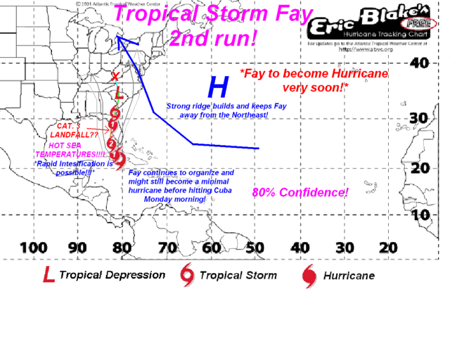
Does that say Cat 3 making landfall?
--------------------
Tracking Storms Since 2004
Miami, Cocoa, Fort Myers and Jacksonville
Currently Reside in New England
|
scottsvb
Weather Master
Reged:
Posts: 1184
Loc: fl
|
|
That is his forcasted... Dont take mine , his or anyone elses over the ...
|
allan
Weather Master
Reged:
Posts: 468
Loc: Palm Coast, Florida
|
|
Like I said earlier, I might be overdoing the strength, so scottsvb is right, don't take mine for granted but I guess look at it like a model for right now.
--------------------
Allan Reed - 18,9,5
|
ftlaudbob
Storm Chaser

Reged:
Posts: 829
Loc: Valladolid,Mx
|
|
Just when I thought I was out of the woods.We should be back in the cone at 8:00,and the forecast track should shift even farther east.
Looks like Tampa misses another one.
--------------------
Survived: 10 hurricanes in Rhode Island,Florida and the Yucatan of Mexico .
Edited by ftlaudbob (Mon Aug 18 2008 06:55 AM)
|
MichaelA
Weather Analyst

Reged:
Posts: 952
Loc: Pinellas Park, FL
|
|
Until we get a reliable fix on Fay's location and strength, the models and forecast track/strength are going to be variable. I don't see a consensus developing until later today. I'm still leaning toward a NE or NNE track with landfall south of Tampa Bay. Of course, that's just my guess.
--------------------
Michael
PWS
|
ftlaudbob
Storm Chaser
Reged:
Posts: 829
Loc: Valladolid,Mx
|
|
On the 5:00 am update it has movement at NNW,so to me it looks like it's making that turn earlier than expected.
--------------------
Survived: 10 hurricanes in Rhode Island,Florida and the Yucatan of Mexico .
|
willw
Weather Watcher
Reged:
Posts: 32
|
|
If you're watching...
http://radar.weather.gov/ridge/radar.php?rid=BYX&product=N0Z&overlay=11101111&loop=yes
or
http://www.wunderground.com/wundermap/?l...ur=0&fire=0
that's nnw ? If that's the eye coming off cuba.It looks NORTHWEST to me. But that's my naked eye opinion..
|
Ed in Va
Weather Master
Reged:
Posts: 489
Loc:
|
|
Lot of convection SE of Miami. Think there's any chance that the center will reform there?
--------------------
Survived Carol and Edna '54 in Maine. Guess this kind of dates me!
|
JMII
Weather Master

Reged:
Posts: 546
Loc: Cape Coral & Margate, FL
|
|
Fay got ripped apart, all the activity is NE of the center. She's got a very small window to get her act together, water vapor shows she is trying to wrap up but the squeeze play is on. Still not sure what the models were seeing yesterday that caused them to move west as the High in the Atlantic is breaking down, looks like she'll wobble or reform slightly NW of her current position then arch to the NNE. Landfall in the same area as as Cat 1 is my call too. The structure is just not there (yet) for anything that strong. Plus the worst of the weather will be east over the FL Keys and Miami area regardless.
--------------------
South FL Native... experienced many tropical systems, put up the panels for:
David 79 - Floyd 87 - Andrew 92 - Georges 98 - Frances 04 - Wilma 05 - Matthew 16 - Irma 17
Lost our St James City rental property to Ian 22
|
JMII
Weather Master
Reged:
Posts: 546
Loc: Cape Coral & Margate, FL
|
|
Looks like Fay is NE of the projections. At this point she looks to go slight east of Key West (thru Big Pine Key maybe), then make landfall around Naples as TS. Personally I don't think we'll even get to Cat 1 levels as currently the wind is only blowing at 40 mph in Key West. Just doesn't seem like she's got the time or upper level environment to build up to 75 mph within the next 24 hours.
Hope everyone remains un-FAY-zed by this sloppy storm 
--------------------
South FL Native... experienced many tropical systems, put up the panels for:
David 79 - Floyd 87 - Andrew 92 - Georges 98 - Frances 04 - Wilma 05 - Matthew 16 - Irma 17
Lost our St James City rental property to Ian 22
|
Ed in Va
Weather Master
Reged:
Posts: 489
Loc:
|
|
Agreed. I think the only chance Fay has to to strengthen significantly is to get to the Atlantic. Looks like the continued land interaction in the Gulf will not give any time for development.
We seem to have lost the graphics on 94L, but it's coming together. Looks more organized than Fay at this point:
http://www.ssd.noaa.gov/goes/flt/t2/loop-vis.html
--------------------
Survived Carol and Edna '54 in Maine. Guess this kind of dates me!
|
WeatherNut
Weather Master
Reged:
Posts: 412
Loc: Atlanta, GA
|
|
I'd say this one 94L will be a TD very shortly if the convection that fired over the center can maintain with all the dry air in the area
--------------------
Born into Cleo (64)...been stuck on em ever since
|
StrmTrckrMiami
Weather Guru
Reged:
Posts: 148
Loc: Manchester, NH
|
|
Quote:
I'd say this one 94L will be a TD very shortly if the convection that fired over the center can maintain with all the dry air in the area
Where is 94L?
--------------------
Tracking Storms Since 2004
Miami, Cocoa, Fort Myers and Jacksonville
Currently Reside in New England
|
gatorman
Verified CFHC User
Reged:
Posts: 23
Loc:
|
|
am i alone, it looks from radar that there isnt an eye yet(which would make this easier to spot) but looks to me Fay has almost a northwest movement?? maybe its wishful thinking, but see what yall think???
|
tampaboy26
Unregistered
|
|
94L looks like it gettin its act together... its beginning to twist
|
JMII
Weather Master
Reged:
Posts: 546
Loc: Cape Coral & Margate, FL
|
|
Fay is moving north and getting more organized. I predict a Naples landfall as a minimal Cat 1 around 5AM tomorrow. Just my $.02 which doesn't buy much these days 
--------------------
South FL Native... experienced many tropical systems, put up the panels for:
David 79 - Floyd 87 - Andrew 92 - Georges 98 - Frances 04 - Wilma 05 - Matthew 16 - Irma 17
Lost our St James City rental property to Ian 22
|


 Threaded


